 ">
">
20 of the Top Day Hikes in New Hampshire
When most people think of mountains, their minds often turn to images of jagged, bare, glaciated peaks soaring high in the sky. They think of the Alps or the Rockies; Alaska or Nepal. But we on the East Coast of the United States know that just because the mountains here aren’t big, that doesn’t mean they aren’t beautiful. Nor does it mean that climbing them won’t thoroughly kick your ass, as evidenced by these top day hikes in New Hampshire.
New Hampshire is home to the majestic White Mountains, as well as the Belknap and Monadnock ranges, where hikers can find stunning views, challenging climbs, and one of the oldest and most well-established trail systems in the country. The following list is a mere sampling of the outdoor adventure to be found in the Granite State. Use this article to get started, and then do yourself a favor and purchase a copy of the AMC White Mountain Guide for information on the hundreds of amazing hikes that this tiny New England state has to offer the outdoor enthusiast.
Some trailhead parking requires a day use fee, and hikers have the option of purchasing a White Mountain National Forest recreation pass.
Happy hiking, and stay safe out there!
Listed from easiest to hardest (roughly).
The Top Day Hikes in New Hampshire
1. Diana’s Baths
Length: 1.2 miles round trip
Difficulty: Easy
Trailhead location: 2.3 miles west of downtown North Conway, on River Road.

A rare shot of Diana’s Baths without the crowds.
If you want a short, scenic hike that is accessible and fun for people ages two to 102, Diana’s Baths definitely fits the bill. Walk .6 miles down a wide and very mildly graded woodland path to a series of waterfalls and swimming holes that epitomize White Mountain summer fun. Be advised that during the height of tourist season on a hot day, the crowds are enormous and the parking situation can easily lengthen your walk by a half mile or more. Consider checking out this location during the off-season when the hordes of swimmers have vanished.
2. Artist’s Bluff
Length: 1.6 miles round trip
Difficulty: Easy
Trailhead location: Just west of exit 34C on the Franconia Notch Parkway (I-93) in a gravel parking lot for Cannon Mountain.

View of Cannon from Artist’s Bluff.
This short, popular hike includes the summit of Bald Mountain and the cliff known as Artist’s Bluff. The small elevation gain yields big rewards with spectacular views of Echo Lake, the slopes of Cannon, and the high peaks of Franconia Notch. Pro tip: grab your microspikes and head here in the winter to avoid the summer crowds and to watch the skiers make their way down Bode Miller’s home mountain across the street.
3. Franconia Falls
Length: About 6.5 to seven miles round trip
Difficulty: Easy
Trailhead location: Lincoln Woods parking lot off the Kancamagus Highway (Rt. 112) East of Lincoln, NH.

Water as beautiful as it is freezing.
If you’re looking for waterfalls and swimming holes but don’t want to deal with the crowds at Diana’s Baths, you might want to check out Franconia Falls. The Franconia Falls Trail can be reached by walking three miles along the wide, flat old rail trail known as the Lincoln Woods Trail. Eventually you will reach a bridge. Before crossing the bridge, you will notice the Franconia Falls Trail branching off to the left. The trail extends for about .5 miles. Keep walking until you find the perfect spot to set up your picnic lunch and enjoy a plunge in the ice cold water.
4. Mount Major
Length: Three miles round trip
Difficulty: Moderate
Trailhead location: South of Lake Winnipesaukee on NH Rt. 11 about four miles west of Alton Bay.
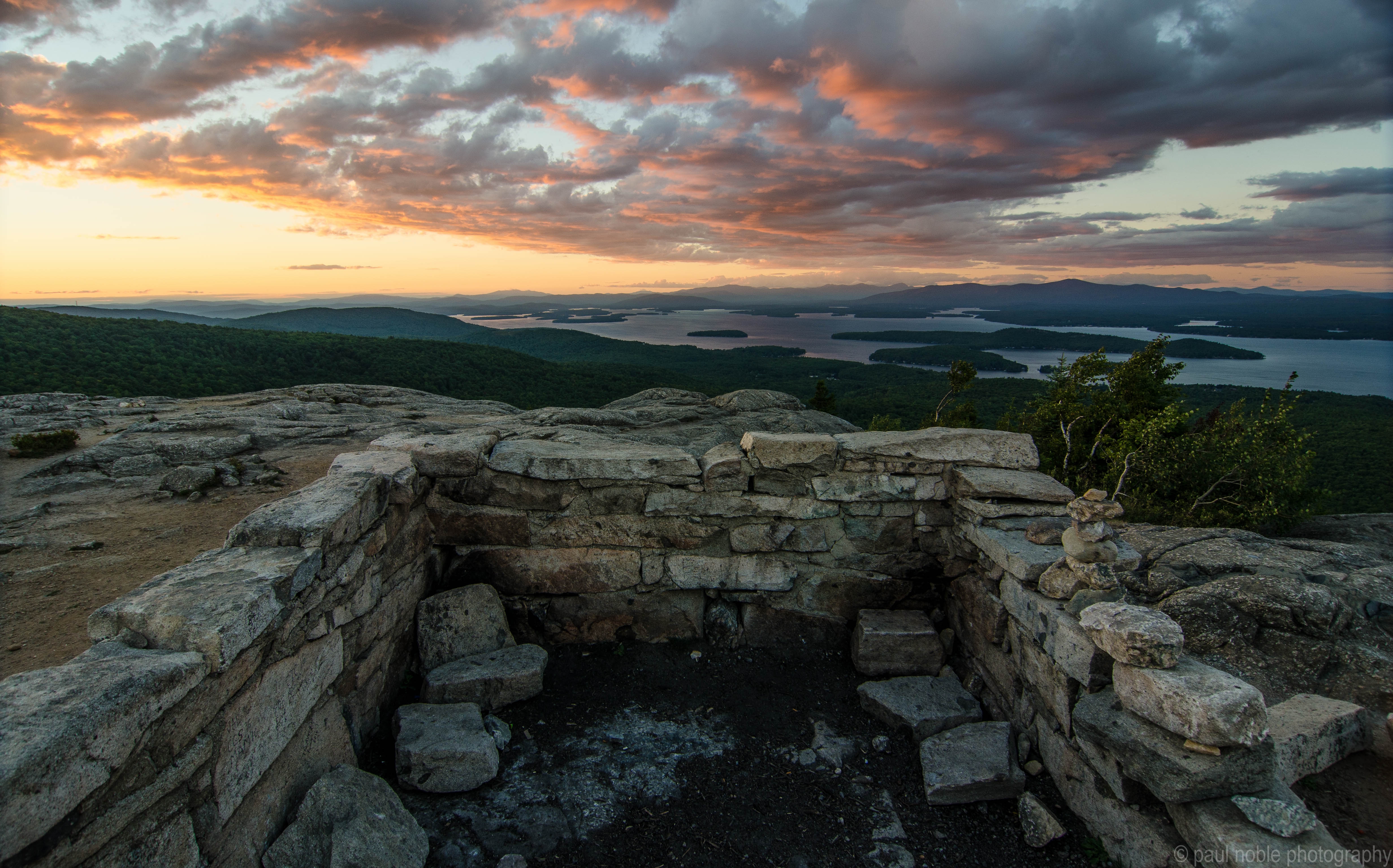
Ruins of the hut on top of Mount Major
Ask any resident of New Hampshire if they have climbed Mount Major and I guarantee that no matter their experience level or enthusiasm for the outdoors, the answer will be yes. Like Diana’s Baths, Mount Major hosts some truly massive crowds during the summer, but make the trip up this little peak and you will understand why. A half mile walk from the parking lot to the trail, followed by a surprisingly persistent (and occasionally quite steep) mile to the top is rewarded with stunning views of Alton Bay from a wide, bare, rocky summit. A great place to take kids, as well as friends who are new to hiking.
5. Lonesome Lake
Length: Three miles round trip
Difficulty: Moderate
Trailhead location: Lafayette Place Campground off Franconia Notch Parkway (I-93).

View from the dock at the Lonesome Lake Hut.
This short but very persistent hike leads up to a pretty alpine lake with stunning views of Franconia Ridge. Stop in at the AMC hut to chat with the caretakers and enjoy some baked goods, go for a swim, and take a leisurely stroll around the perimeter before heading back down.
6. Morgan and Percival
Length: 5.5 miles round trip
Difficulty: Moderate
Trailhead location: Rt. 113A in Holderness, just a few miles north of Squam Lake.

Small peaks, big views.
This hike could very well be the definition of fun-for-the-whole-family. While it is probably too long and challenging for very small children, the caves, cliffs, ladders, and epic views of Squam Lake will certainly be enough to hold the attention of those who ride without training wheels and swim without water wings. Pro tip: hit up the general store at the junction of Rt. 3 and 113A a couple miles south of the trailhead for some amazing sandwiches to eat at the top.
7. Mount Chocorua via the Champney Brook Trail
Length: 7.3 miles round trip
Difficulty: Moderate
Trailhead location: About ten miles west of Rt. 16 on the Kancamagus Highway (Rt. 112)
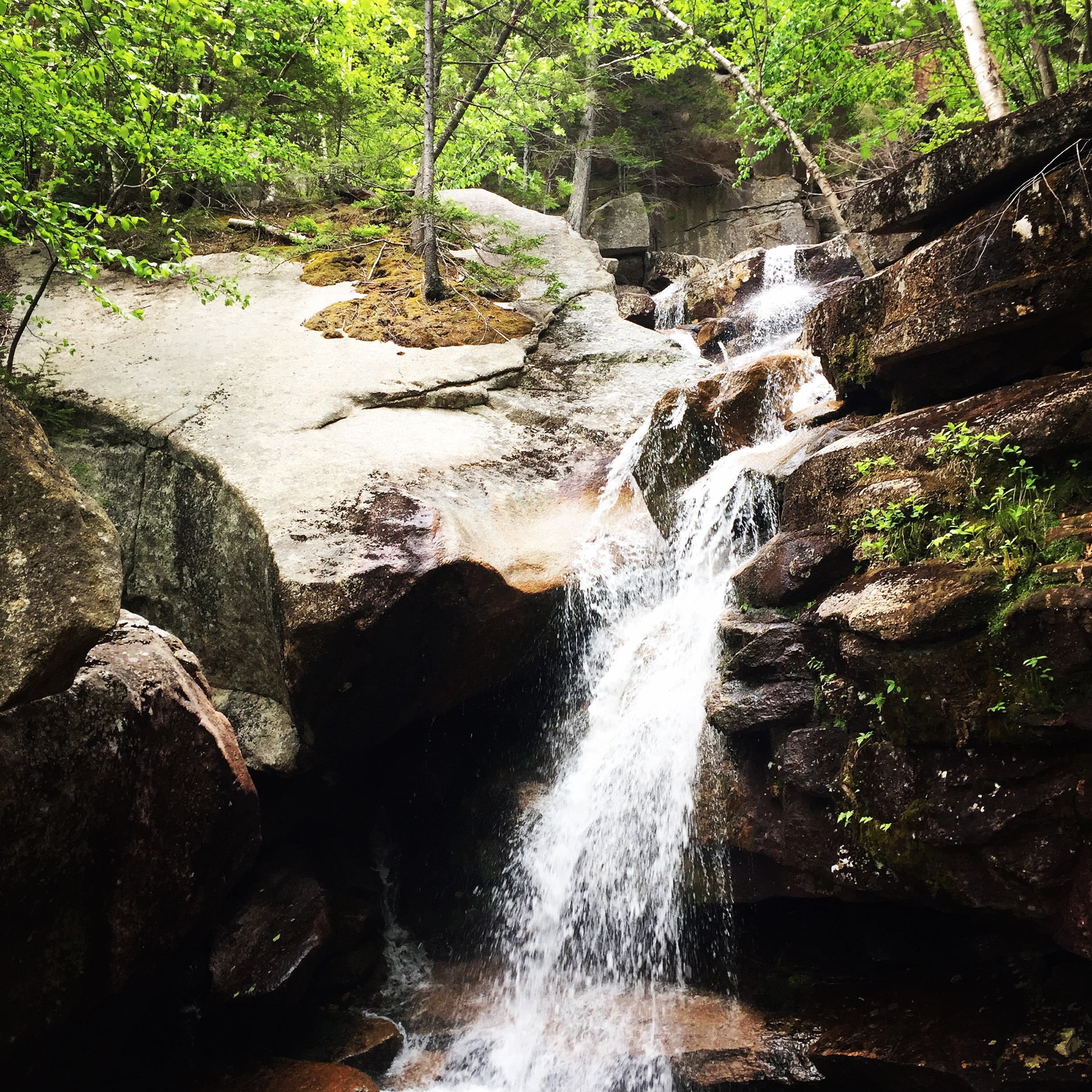
One of the many cascades on the Champney Falls Trail.
The more popular route up Chocorua is probably the Piper Trail right off of Rt. 16, but I have never understood why because if you simply drive north and then west for another 25 minutes you can get the same incredible views from Chocorua’s bald, bouldered summit and experience a series of beautiful cascades on the way up and down. The Champney Brook Trail is only slightly steeper than the Piper Trail, with a fair chunk of it consisting of gentle switchbacks. As with all trails leading up this mountain, the hardest part is finding your way to the very top.
8. Mount Monadnock via the Pumpelly Trail
Length: Nine miles round trip
Difficulty: Moderate
Trailhead location: Lake Road off Rt. 101 in Dublin.

Monadnock on a hazy day
There are approximately nine million ways to get up Mount Monadnock, but if you want to make it a longer and more challenging hike with lots of exposure and lots of views, the Pumpelly Trail is a great option. The trail starts out as a fairly easy ramble along a wooded path past private homes before taking a turn and heading uphill, first through the woods and then along a series of rocky ledges (some might call them false summits) to the top. Make sure you pay attention to the direction you came from and the blazes you are following. There are many trails on Monadnock and it is very easy to start following the wrong one on the way down.
9. Mount Carrigain
Length: Ten miles round trip
Difficulty: Moderate
Trailhead location: About two miles up Sawyer River Road (a dirt road) off Rt. 302 near the southern end of Crawford Notch State Park.

View of Signal Ridge from the lookout tower.
Mount Carrigain and the Signal Ridge Trail have some of the best views in the Whites. The trail starts out flat and then gently ascends Carrigain via a series of switchbacks (something so rare in these parts) until you come out to an exposed ridgeline with dramatic views on either side. The trail then heads back into the woods and takes you up to the summit of Carrigain, where there is a lookout tower with even more views, including an incredible one of the ridge you just traversed.
10. Franconia Ridge Loop
Length: Eight miles round trip
Difficulty: Moderate to hard
Trailhead location: Exit for Falling Waters Trail/Old Bridle Path off Franconia Notch Parkway (I-93).

Nothing like a clear day on Franconia Ridge.
I don’t have any solid numbers in front of me, but based on personal experience I would say that this might be the most popular hike in the White Mountains. The trailhead is easy to access and the views are breathtaking. Even if you don’t happen to catch it on a clear day, the fog rolling over the ridge will make you feel like you’ve stepped right into the Lord of the Rings. Pro tip: take the Old Bridle Path up Lafayette and the Falling Waters Trail down Little Haystack so that you get the biggest climb over with in the beginning and have a series of beautiful waterfalls to look forward to at the end.
11. Webster and Jackson
Length: 6.5 miles round trip
Difficulty: Hard
Trailhead location: Rt. 302 near the northern end of Crawford Notch State Park.

Crawford Notch=amazing.
A unique hike with a huge payoff. This tough but rewarding loop takes you to the summits of Mounts Webster and Jackson, which are connected by a ridge that features a series of cliffs with absolutely stunning views of Crawford Notch and the Presidential Range.
12. North Moat Mountain
Length: 8.9 miles round trip
Difficulty: Hard
Trailhead location: Park at the Diana’s Baths trailhead 2.3 miles west of downtown North Conway on River Road.
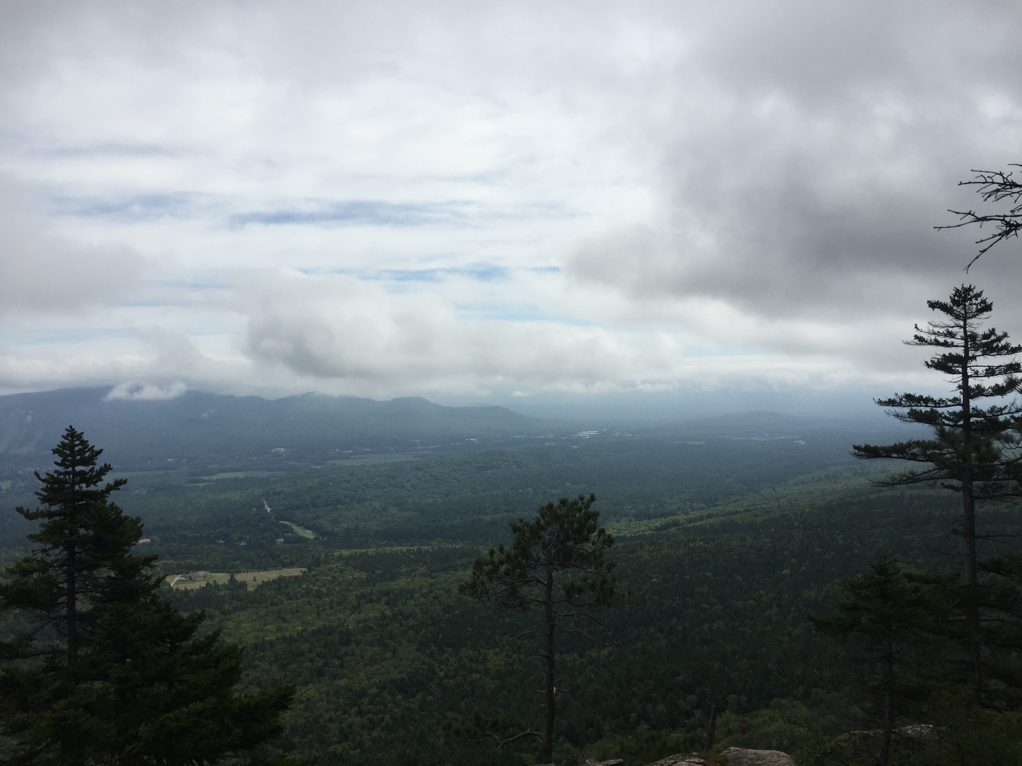
Even on a cloudy day you can still see a lo.t
Driving along Rt. 16 through North Conway, it is pretty much impossible to miss the Moat range west of town. Home to Whitehorse Ledge, Cathedral Ledge, and Diana’s Baths, this area offers visitors quite the adventure. One of the best ways to experience it is by passing through Diana’s Baths and heading toward Red Ridge to climb Moat’s north peak, which offers sweeping views from a bald summit covered in short, scrubby pines and a pretty killer workout.
13. Mount Whiteface via the Blueberry Ledge Trail
Length: 7.4 miles round trip
Difficulty: Hard
Trailhead location: Ferncroft parking area off Rt. 113A.

Mmmm, blueberries.
Located in the typically mellow Waterville Valley region, hikers may be surprised to find that this is actually quite a technical trail. Parts of it are extremely steep and require a bit of rock scrambling. The Blueberry Ledge Trail, however, is well worth the effort. The trail is incredibly scenic–even the parking lot has stunning views–and if you hike it in July or August you will almost certainly get to enjoy the delicious wild blueberries for which the trail is named.
14. Carter Dome and Mount Hight
Length: 10.2 miles round trip
Difficulty: Hard
Trailhead location: 19 Mile Brook Trail parking area on Rt. 16 approximately four miles north of the Pinkham Notch Visitor Center.

View of Wildcat and Carter Lake from halfway up Carter Dome.
Think of everything you want out of a hike in the White Mountains–a gentle walk along a mountain stream, a beautiful alpine lake, a rugged climb to a summit with jaw-dropping views, the opportunity to bag a 4,000 foot peak, an AMC hut with snacks and hot chocolate–and then buckle up because this hike has it all. Take the 19 Mile Brook Trail for 3.8 miles all the way to the Carter Notch Hut and Carter Lake, then take the Carter-Moriah Trail up to the summit of Carter Dome to bag your 4K, follow the trail over to Mount Hight for the 360-degree views, and then make your way back down via the Carter Dome Trail. You can do the loop in reverse so that you wind up hitting the hut on your way back, but just keep in mind that the one-mile section between the summit of Carter Dome and the Carter Notch Hut is very steep.
15. Mount Moosilauke via the Beaver Brook Trail
Length: 7.6 miles round trip
Difficulty: Hard
Trailhead location: Beaver Brook parking area about six miles west of exit 32 off I-93 on Rt. 112.

View on the way up the Beaver Brook Trail, nbd.
Mount Moosilauke is a classic White Mountains hike with classic White Mountain views on a classic granite White Mountains summit. The Beaver Brook Trail may be the most treacherous way to get up this beauty, but it is by far the most exciting. The whole way up, you will be treated to a series of spectacular waterfalls, while the whole way down you will be able to see tremendous views of the Kinsman range to the east. Take your time and watch your step and you should be just fine.
16. Baldface Circle Trail
Length: 9.8 miles round trip
Difficulty: Strenuous
Trailhead location: Right along the NH/ME border on Rt. 113 about 15 miles north of Conway, NH.

Looking from the north peak of Baldface to the south peak.
The crazy thing about the Baldface Circle Trail is that even though a lot of people seem to know about it and even though it is one of the most epic hikes in the White Mountains, no one ever seems to be hiking it. Perhaps that is because it is just far enough away from everything else, but if you are looking to have an incredible trail all to yourself, Baldface is definitely your best bet. Do it on a clear day for two reasons: 1) the views are spectacular and 2) you do not want to hike this trail when it’s wet (you will see what I mean). Be sure and check out the Emerald Pool on your way back to the trailhead. Pro tip: whatever you do, make sure you go up the south side. Trust me, that is not the way you want to go down.
17. Flume and Liberty
Length: Ten miles round trip
Difficulty: Strenuous
Trailhead location: Look for the sign that says Appalachian Trail near the Flume Gorge Visitor Center on Rt. 3 right before it merges with I-93 north.

Summit of Mount Flume.
The slightly less visited southern portion of Franconia Ridge is a frickin’ bear of a hike no matter how you decide to do it, but for the ultimate experience, you simply have to include an ascent up the Flume Slide Trail. Beware that this trail is not for the faint of heart and should not be used in the winter, on the descent, with a heavy pack, or by people who are really scared of heights. But if you don’t mind a challenge and like a little rock scrambling, the slide trail is a ton of fun. Your efforts will be rewarded with the epic rocky summits of Flume and Liberty. Descend down the steep but far less treacherous Liberty Spring Trail to return safely to your vehicle.
18. Bonds Traverse from Lincoln Woods
Length: 22.6 miles round trip
Difficulty: Strenuous
Trailhead location: Lincoln Woods parking lot off the Kancamagus Highway (Rt. 112) east of Lincoln, NH.

View of Bondcliff heading south.
The Bonds are some of the most spectacular peaks in White Mountain National Forest. They are also some of the most remote. If you look at a map you will note that there are several ways to get to the Bonds, but none of them are quick or easy. Still, for perhaps the easiest and most direct route, take the Lincoln Woods Trail to the Bondcliff Trail, make the steep ascent up Bondcliff and Mount Bond, and then head over to the West Bond spur to bag all three peaks in one day hike. Return the same way. It is a long, hard day on the trail, but you better believe that what you see will be worth it.
19. The Presidential Traverse
Length: 17.5 miles end-to-end
Difficulty: Very strenuous
Trailhead location: Northern end: Appalachia parking area off Rt. 2 near Randolph, NH; southern end: Crawford Path parking area off Rt. 302 across the street from the AMC Highland Center.

This view contains not even half of the Presidential Traverse.
If you don’t shy away from long days full of relentless exposure, high winds, steep climbs, loose jagged rocks, and unpredictable weather, this is the hike for you. If you’re into fabulous views and bagging peak after peak after peak, this is also the hike for you. Enlist a friend or two and park one car in Crawford Notch, then drive up to the Appalachia parking lot and start the very steep ascent up Mount Madison via the Valley Way Trail. Get the two biggest climbs up Madison and Adams out of the way, then head to Jefferson, Washington, Monroe, Eisenhower, and Pierce, and then make your way back down Crawford Path. Pro tip: if you get way too tired after the first few peaks, you can always just stay on Crawford path and avoid the spur trails to the summits (you will still get killer views).
20. The Pemi Loop
Length: About 33 miles round trip
Difficulty: Superhuman
Trailhead location: Lincoln Woods parking lot off the Kancamagus Highway (Rt. 112) east of Lincoln, NH.

How much are you really suffering if the trail looks like this the whole way?
The Pemi Loop has been called the second-hardest day hike in the United States, and for good reason. Whether you choose to go clockwise or counterclockwise, you can expect around 18,000 feet of elevation gain over technical terrain. Why endure all that punishment? Well, the Pemi Loop happens to string together a large number of the White Mountains’ best hikes, and once you get above treeline, the whole loop is visible almost the entire way, making this a truly unique experience. Most who do the Pemi Loop turn it into a nice two to three day backpacking trip, but for those who are simply a different breed of human altogether, the Pemi Loop offers the ultimate single day challenge.
What are your favorite New Hampshire day hikes? Let us know in the comments!

This website contains affiliate links, which means The Trek may receive a percentage of any product or service you purchase using the links in the articles or advertisements. The buyer pays the same price as they would otherwise, and your purchase helps to support The Trek's ongoing goal to serve you quality backpacking advice and information. Thanks for your support!
To learn more, please visit the About This Site page.

Comments 7
Thank you ! Lots of great ideas, love it !! tony clifton taxi
These are indeed great hikes in beautiful places. However, as a resident of the Granite State I would like to encourage hikers, bloggers, writers and all those that enjoy and care about the outdoors to think differently about how we publicize our favorite hikes. Many of the hikes in this post are exceptionally crowded most of the year. I drive by Mount Major every day going to work. From Memorial Day to Labor Day the parking lot is full, cars are lined up and down Route 11, and there were so many busses the state banned them from the parking lot. I have seen Franconia Ridge when it looks like a scene on Chilkoot Pass during the Klondike gold rush. We all want to share our experiences, and we want to encourage others to enjoy the experiences that we cherish. But unfortunately our planet is too crowded and we have to begin to think differently. I encourage you at The Trek to consider how to balance our need for wilderness with the reality of overcrowding on the most popular trails. The AT and most of the White Mountains are overcrowded, overused, and show the effects. Large sections of the AT are deeply eroded, campsites are everywhere – most within the limits of where camping is banned, and the signs of overuse are increasing. I avoid AT trails whenever possible because these sections often belong on the Morning Traffic Report.
So my proposal is to encourage hikers to appreciate the less well known trails. I often hike alone. I am not young and my contemporaries are often shocked when I describe trips alone into places I have never been before. But its the uncertainty, the fear in the back of my mind, the little lump in my throat that makes it so much fun. Doing things you know you can do has limited appeal. Doing things you never dreamed you were capable of is the stuff of self-satisfaction. Long distance hiking is only one way to accomplish this. Another is to hike out of the way places, maybe do a little bushwhacking, by yourself with nothing but a bag o junk and your wits and skills to keep you safe. Try it – and try to avoid the trails that feel like suburban commuter routes.
You wonder why this guy hikes alone? What a hero
I disagree,his points are more than valid,as a Native New Hampshireite ,its true the trails are taking a beating,AMC does a great job but i think there is a respect issue for OUR Wilderness
You mean our wilderness? As far as I can tell, the vast majority of these trails are in the White Mountain NATIONAL Forest.
Great points you make…I agree completely!
People need to be taught how to hike and camp responsibly. These places are popular for a reason – easy to access and for many of us in NH and even MA they’re doable in a day. I used to hike a lot in the Adirondaks back in the 90s and I’m just getting back into it after moving to NH. I think it is important to engage with the hikers we see out on the mountains and help them understand the importance of Leave No Trace, carry in carry out, and to leave the mountains better than we found them. It doesn’t help to sling insults and call each other names on someone’s blog. Personally, the only hike on the list I’ve done is the Franconia Ridge Loop and I look forward to getting out and doing the rest of the hikes on this list along with finding the trails less traveled.