 ">
">
9 Long Trails That Belong on Your Bucket List
Good news: There are more trails in the world than we can ever hope to hike in our lifetime.
Bad news: There are more trails in the world than we can ever hope to hike in our lifetime.
Now that we’ve established that you (probably) won’t be able to see every mile of every trail around the world, here’s a head start to your bucket list. The following are five incredible trails explored and explained by experienced backpacking enthusiasts who want nothing more than to share the joy of the trail with you. Whether you’re in the mood for desert, tropics, mountains, or open balds- a weekend getaway or extended adventure- take your pick and start planning.
The below descriptions are meant only to wet your whistle- click on the links of each post to diver deeper down the rabbit hole.
1) The Wonderland Trail
Location: Washington
Distance: 93 miles

The Wonderland Trail is unique in many ways, least of all that it circumnavigates the imposing Mt. Rainier, exposing hikers to the incredible ecosystem around the peak. Expect exposed bridges, lots of wildlife, and a Rainier beer at the finish. This trail requires a permit, so get on it. Read more here.

2) The John Muir Trail
Location: California
Distance: 211 miles
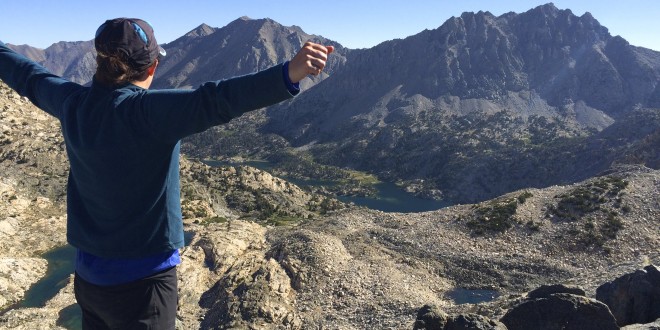
While we hold the entire PCT close to our hearts, this section is commonly considered the crown jewel of the PCT. Don’t expect to thru-hike the JMT on your first permit attempt: due to high demand, ~90% of all permit requests are denied. Don’t give up though! Not a mile of this trail is anything less than jaw-droppingly gorgeous. If you can’t thru-hike the JMT, pretty much anything in the Sierras/Northern California is a safe bet for an A+ backpacking trip. Read more here.
3) The Oregon Desert Trail
Location: Oregon
Distance: 750 miles

Who’s ready for a challenge? This newly established trail won’t give you much in the way of signs or fellow hiker trash, and you’ve got to be confident with a map/compass/GPS. For those who fit the bill, exploring the high desert of Oregon (did you even know Oregon had a high desert?) is something to aim for. You’ll see herds of pronghorn and miles upon miles of wide open sky. You’ll also get the designation of being one of the first badasses to thru-hike the ODT. Put that on a resume. Read more here.
4) The Kalalau Trail
Location: Hawaii
Distance: 22 miles
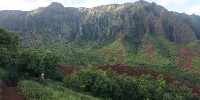
When hiking nuts take a trip to Hawaii, you better believe they aren’t sitting on a beach sipping fluorescent drinks all day. This trail has the adventure not normally associated with a Hawaiian vacation, including exposed cliff-side tread, potential for flash floods, and hordes of feral goats. You’ll also get to see remote, wild beauty, lush foliage, and stunning waterfalls. Read more here.
5) Irish Coast-to-Coast Walk
Location: Ireland
Distance: 370 miles

Take a jaunt overseas to explore this traverse of Ireland. Hikers experience everything from jagged peaks to the pounding ocean, historic towns to remote open plains. The majority of the trail crosses over balds, making sure you’re getting 360-degrees of photo opportunities every day. There are several sections of the Irish Coast-to-Coast Walk, so take your pick. Or hike all of them. We won’t stop you. Read more here.
6) The Long Trail
Location: Vermont
Distance: 272 miles
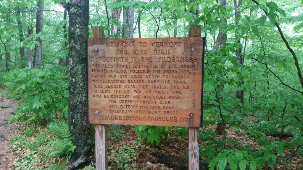
By the time NOBO AT hikers get to Vermont, many are a little tired of hiking. That, plus the notorious mud for the 100 miles of Vermont that the AT traverses might give the Green Mountain State a bad rap, but the Long Trail is one of the oldest and most rugged long-distance trails in the country, and most people agree the northern half is > than the southern half. So AT thru-hikers- you’ve already hiked half of the Long Trail. Might as well go finish it up. Read more here.
7) The Ice Age Trail
Location: Wisconsin
Distance: 1,200 miles

Did you know there’s a long-distance trail through Wisconsin? Did you know it’s over 1,000 miles long? The fact that half of it is blazed and half is unmarked connecting trails make this even more fun. The most recent period of the Ice Age (the Wisconsin Glaciation) ended about 10,000 years ago and left behind unique, fascinating terrain throughout the state. The Ice Age Trail passes along fens, potholes (not the kind found on bad roads), swales, dells, and more. Guess you’ll have to hike it to see what the heck those all look like. Read more here.
8) Mountains to Sea Trail
Location: North Carolina
Distance: 1,150 miles

North Carolina: Another state we bet you didn’t know had a long-distance trail. North Carolina is know equally for its incredible coastline and gorgeous mountains. This trail gives you the best that the state has to offer, including completed hiking sections (some miles will look familiar to AT hikers), bicycle sections, and even a ferry-hop to officially complete the trail. The Mountains to Sea Trail also offers a multitude of day hiking and shorter trip options whether you’re near the coast or in the mountains. Read more here.
9) Foothills Trail
Location: North Carolina & South Carolina
Distance: 77 miles

Sometimes it’s not all about getting to the highest peak in sight. The foothills of many mountain ranges offer their own network of trails with equally satisfying beauty as their larger counterparts. This trail is incredibly well-maintained with well-placed signage, smartly planned sections, and dedicated trail crews keeping it smooth and clear. This is a versatile trail, as it can be done in just a few days for fast-packers, or up to a week or more if you’re taking your time. Get ready for challenging elevation gain, waterfalls every day, and sandy riverside beaches. Read more here.
Many more trail features to come. Which would you like to learn more about? What’s on your bucket list. Let us know in the comments below.

This website contains affiliate links, which means The Trek may receive a percentage of any product or service you purchase using the links in the articles or advertisements. The buyer pays the same price as they would otherwise, and your purchase helps to support The Trek's ongoing goal to serve you quality backpacking advice and information. Thanks for your support!
To learn more, please visit the About This Site page.

Comments 9
North Country Trail? Superior Hiking Trail? Border Route Trail? Kekakabic Trail? PowWow Trail? Sioux Hustler Trail?
You must have something against Minnesota…
GR5/GR10/Gr20 in France? GTA in the Alpes ? Tre Araroa NZ?
You must have something against the non-US part of the world i guess 😉
Exactly my thoughts as well.
Currently without a name, but in 10 years, it may be called the New England Trail, the Greater New England Trail, or the Ghost Trail. It consists of several current, on the ground trail but with a relatively small gap of road walking.
2) The current New England Trail, a protected National Scenic Trail from Long Island Sound at Guilford,CT to Mt Monadnock in Jaffrey,NH.
2) The Monadnock-Sunapee Greenway to Mt Sunapee.
3) Short Trails to Mt Keaksarge in Warner,NH.
4) The GAP: A few possible road routes to Welch-Dickey.
5) Welch-Dickey, Tecumseh to the top of Waterville Valley..
6) Mad River Notch (Greely Ponds) to the lower hairpin of the Kancamagus Highway. Road walk to the upper hairpin, enter the Pemigewassett Wilderness.
7) Several routes in the Pemi, but the most expedient is Hancock Notch, down Sawyer River to Rt.302, and about 2-3 miles on the road to the base of the COHOS Trail. The Reds expedient route is either Cedar Brook Trail to the AT, or Hancock & Carrigain Notches to the AT, then the AT to RT.302 and a road walk south to the base of the COHOS Trail.
8) The COHOS Trail to the Canadian border.
9) The Fonteniers Trail to Mt. Megantic, in the PQ.
The International Appalachian Trail from the Togue Pond entrance at Baxter State Park to the end of the Gaspe Penninsula, another 600 miles.
However: the legal route requires a road-walk around and outside of the southern limits of the Baxter State Park. This is unacceptable.
What is obviously “Appalachian” is from Baxter Peak, either the Knife Edge to Roaring Brook, Russel Pond, and exit the BSP via the Traveler Mountains – or – from Baxter Peak, Hamlin Peak, the Howe Peaks to Russell Pond, and exit the BSP via the Traveler Mountains.
This exit from The BSP via The Travelers is currently illegal. The IAT will need federal protection via National Scenic Trail designation, or to be intergrated into the pre-existing NST protected AT. The BSP Authority has been somewhat restrictive to AT thru-hikers over the years. They are unlikely to accommodate the IAT exit route over the Travelers without the supremacy of federal law (National Scenic Trails Act) vs state law (BSP charter).
The East Coast Trail in eastern Newfoundland, Canada!
That’s a particularly nice one. More info here:
ectthruhike.com
Superior Hiking Trail – I am from MN and my mother just bought a cabin a few miles away from it
Colorado Trail – or the whole CDT
Te Araora
Kungsleden
Kumano Kodo and Nakasendo Trail in Japan
The central mountain range in Taiwan – lived here for 7 years
European Peace Walk – don’t know much about this but I want to visit these countries
Probably a few others but first I need to save up a lot of money and get myself back into thru-hiking shape
My bucket list has more than 9 on it!