 ">
">
A Lesser Known Thru-Hike: The Scottish National Trail
The Scottish National Trail is 470 miles (756km) of tracks, footpaths and sometimes just a line on a map that links up established trails into one long end-to-end hike across Scotland. Most people hike northbound, starting in the Borders region, as the trek steadily gets harder and more scenic as you advance higher up the country. In September my friend, Zyg, and I decided to hike southbound on the SNT as we wanted to tag on the Pennine Way in order to walk home to Sheffield.
The first week
It began with a long journey north by train to Thurso, Britain’s most northerly town, and then west by bus across the beautiful northern coast to Durness. The trail started at the Cape Wrath lighthouse, but the cape is a Ministry of Defence training area, and we couldn’t get to the lighthouse on the day we started— Sundays are the only day without live firing outside of summer. Instead, we bought an OS map in Thurso and hiked off-path through bog to get to Sandwood Bay. We hadn’t heard of anyone else doing this, but I think it is a genuine option if you need to avoid the danger area further north.
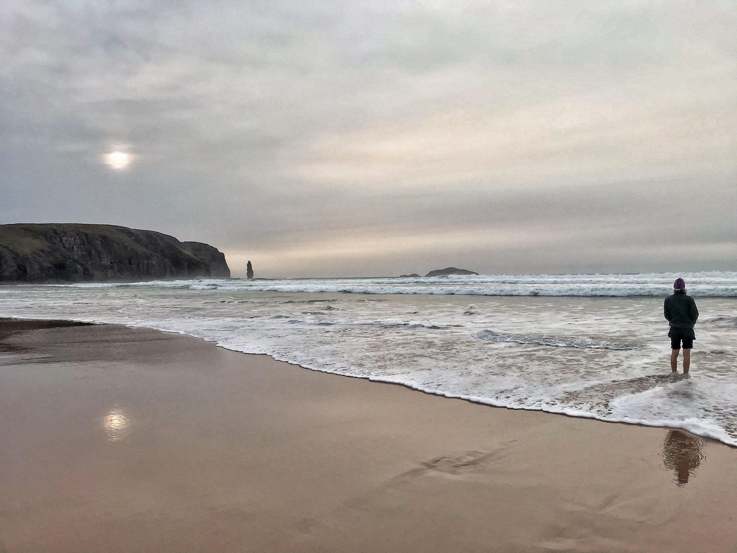
At Sandwood Bay, we enjoyed our first spectacular views and awe-inspiring atmosphere of the hike. It’s an equally intimidating and peaceful place, the sort of place that would feel romantic in different company. We camped on a grassy patch overlooking the beach, ourselves overlooked by tall black cliffs.
September is a perfect month for hiking in Scotland. The infamous midges didn’t bother us at all as it was already too cold for them, yet the temperatures weren’t so low that it killed us off too. September always seems to be fairly dry in the UK, and this year there wasn’t a breath of wind for the majority of the month— it was in October that the weather became more testing. As we hiked further south and we remembered what trees were, there was the bonus of the autumn colours creating some beautiful scenes. Whether going northbound or southbound, I would recommend hiking in September.
After a lengthy road walk from Kinlochbervie, we dived onto a narrow footpath heading inland. We walked along a loch for a while before it started to rain, at which point we hurriedly looked around for a place to camp. The hillside rose steeply from the bank of the loch, and we scrambled up it in search of flatter, more sheltered ground. The result was definitely the worst campsite of my life. The patch was sloping, lumpy and only just out of the direct wind. That night taught me that tents can withstand a lot of abuse and that if you dive inside and try to ignore the flapping, you will most likely be safe, even if you don’t sleep much. It gave me confidence that every subsequent night would be much more pleasant.
The wildlife
The next morning we were rewarded with a brilliant wildlife moment as we saw two stags close to the trail and seemingly unafraid of us. They looked quite young and small, and they were drinking from the loch. Autumn is the rutting season for stags in Scotland and almost every night we heard roaring coming from high up on the mountainsides. Although red deer are majestic animals, their numbers have to be carefully managed as they are considered a nuisance in the Highlands. Deer love to eat young saplings and the bark off trees, meaning that existing trees die and young ones cannot grow. Fences can be erected around areas of trees, but the deer have to culled too because they have no natural predators. Both culling and reintroducing natural predators like wolves and lynx are hotly debated topics in Scotland.
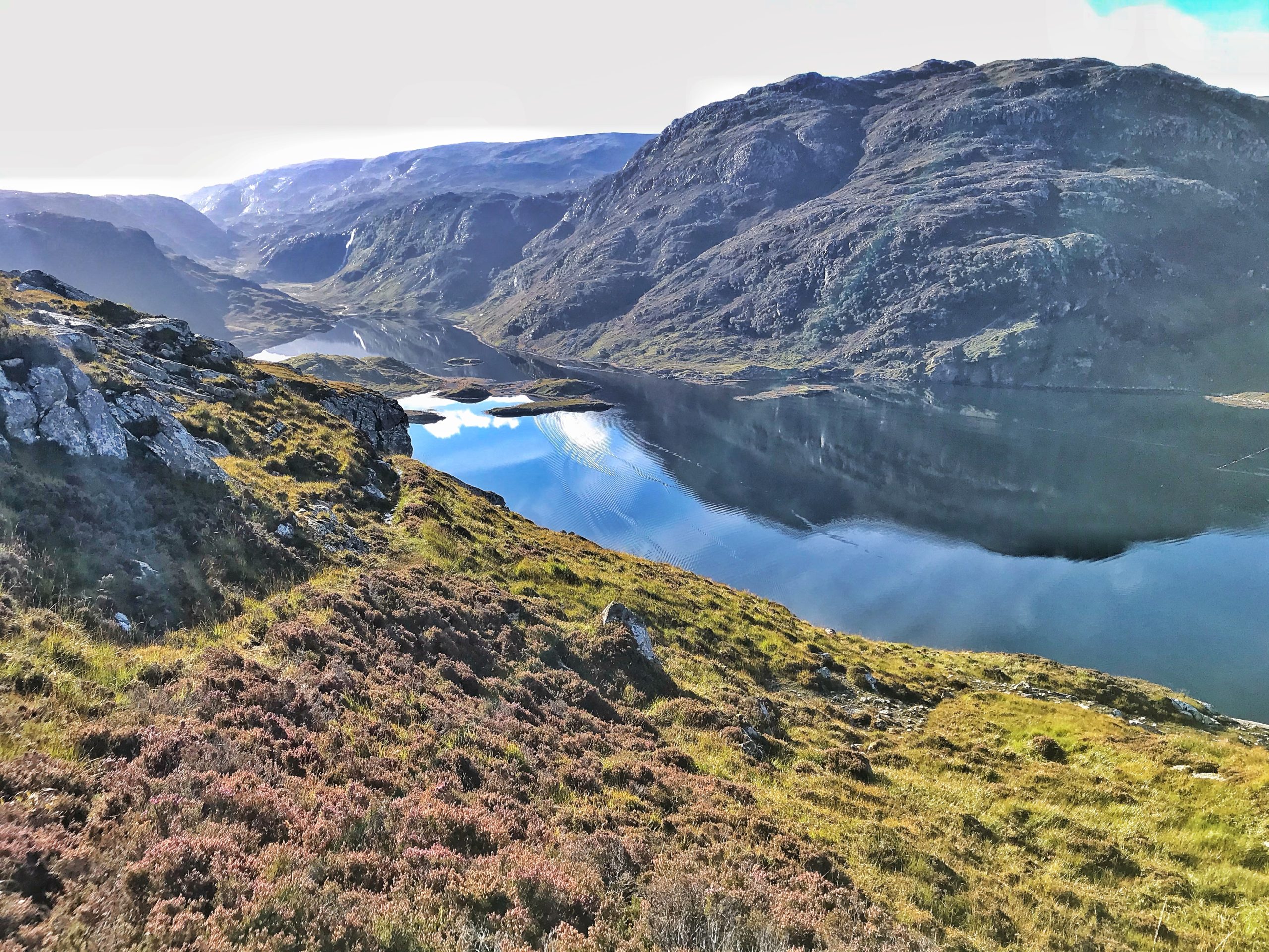
The most dramatic scenery and best views were in the Highlands. Around Glencoul the sea lochs were breathtaking, and Ben More Assynt provided the earliest exciting mountain terrain. The first view of An Teallach ridge was amazing— a high and jagged silhouette in the distance. We skirted around the equally magnificent Ben Eighe.
The Cape Wrath Trail is a brilliant two-week thru-hike in its own right, and I would recommend it to anyone who is time-limited. We continued along the Scottish national trail and joined the Caledonian canal up to Fort Augustus. This famous canal joins up several lochs along the great glen, including Loch Ness, to allow passage through the centre of Scotland. It was important in WW2 for moving munitions, but now it is used only for tourist trips.
Along the canal Zyg showed me just how easy it is to forage food in the UK— there was an abundance of hazel trees, sloes, blackberries, mushrooms. It made us wonder about the food we were eating, and a quick glimpse at the packets confirmed what we feared; palm oil is found in almost all the convenient foods that hikers fuel themselves with. We are both nature lovers, and this trail helped us get in touch with that, so why are we contributing to deforestation on the other side of the world even as we hike through and marvel at our own native forests?
After the Cape Wrath trail
After Fort Augustus, we followed an old military road over the mountains that was built in 1715 for moving armies around the Highlands during the Jacobite revolution. It was exciting to be walking in the footsteps of soldiers, but the road itself was just like any normal 4×4 track, and a line of massive pylons to our right made it a bit less atmospheric.
We entered the Cairngorms via Glen Feshie where we shared a glass of Prosecco with a trail angel at a glamorous bothy. The building was revamped as part of the Glen Feshie estate owned by Anders Povlson, the billionaire owner of Asos. Povlson is the largest private landowner in Scotland with 220,000 acres and 12 estates, and he is a passionate conservationist who uses his money to help rewild the countryside. The glass of Prosecco from his caretaker at the bothy was for reaching halfway on the Scottish National trail, and the friendly old man also promised he would plant a tree for us.
From Fort Augustus onwards, we had started to notice the changing of the trees for Autumn. We declared ourselves amateur naturalists and downloaded an app to help identify trees. We were pleasantly surprised to see an abundance of elm and ash trees that we thought were rare. The animals we saw included seals, red squirrels, hundreds of red and roe deer, grouse and buzzards. For me, this trip helped me appreciate the nature of my country more than ever before.


After the delightful forests, we started on the more urban setting of the central belt canal walks. There are around 45 miles (72km) of tarmac towpath which is completely flat and fairly dull. The view varied little, and the towns along the way were uninspiring, not helped by the inevitable steady rain. With the exception of the impressive Falkirk Wheel, the world’s only rotating boat lift, the canal was, unfortunately, a drag. We found two tennis balls, one significantly more dog-eaten than the other, and took turns kicking them up the towpath in front of us, and fetching them from the overgrown margins. This broke up the monotony for a few hours.
We had a rest day in Edinburgh and walked up Arthur’s Seat, an extinct volcano that dominates the city. It was a relief to walk without the weight of a backpack, but we found ourselves suddenly very tired in Edinburgh. The weather had been terrible on the canal, and the forecast was for more rain. Zyg tentatively touted the idea that we would end early but, once voiced, it was actually an easy decision, and I didn’t even pretend to feel regretful. From Edinburgh, we had a week left, and we would finish at the border town of Kirk Yetholm instead of tagging on the Pennine Way. Regardless, we had both walked the Pennine Way before.
The last week
The route out of Edinburgh was poor in our joint opinion. We felt as though there were more exciting routes through the Pentland hills and on towards Peebles, but instead, there was a fairly long road walk and only a short dash over the hills. If I hiked the trail again, I would choose my own route through the Pentland hills. We tried camping in the public park in West Linton, a village we had cycled through numerous times and that we thought would be quiet and safe, but after dinner, in the dark, the local kids came out and took too close an interest in our tents. Zyg remarked disappointedly that he has camped all around the world yet a small town in Scotland is the only place he has felt uncomfortable. We walked just 2km out of town and found a field to sleep in instead. Apart from this experience, we had no problem with wild camping as it is totally legal in Scotland, as long as you adhere to leave no trace principles.

The last few days were an undulating mix of muddy paths, fields and towns. The landscape felt gentle, but the weather worsened, turning consistently cold. The trail followed established routes through typical British countryside, and we enjoyed the excellent waymarking. In particular, the St. Cuthbert’s way was brilliantly signposted and flowed through a lovely mixture of deciduous trees and cultivated fields.
After climbing the last hill in the Cheviots, we walked into sleepy and deserted Kirk Yetholm and had a meal at the pub. A couple of buses took us to Berwick-upon-Tweed where we changed onto a train, and we were home that evening, relieved, weather-beaten and tired but with the wholesome glow of adventure still inside.
In summary
The Scottish National Trail is a varied, exciting and challenging trail. It took us six weeks to complete. The route features mountain terrain, deciduous and coniferous forests, river walks, rolling fields, ancient roads and bogs, unforgettably. Wild camping is free and legal allowing for some great memories but we were also grateful for nights spent in bothies in the Highlands. As the Scottish National trail is mostly wild and beautiful, the most valuable thing I have taken out of the hike is my increased interest in nature, foraging and conservation.

This website contains affiliate links, which means The Trek may receive a percentage of any product or service you purchase using the links in the articles or advertisements. The buyer pays the same price as they would otherwise, and your purchase helps to support The Trek's ongoing goal to serve you quality backpacking advice and information. Thanks for your support!
To learn more, please visit the About This Site page.

Comments 9
Alex — Really great well written trail article and fantastic photographs of the trek! Makes me want to fly over and do it now (though it would be cold).
I hiked the first section of the Pennine Way in the Peak District a decade ago (Edale to the border with Yorkshire) and still remember it fondly!
Thanks for the kind words! I don’t think I would recommend it for this time of year! Although, the friend I hiked with did the Pennine Way in winter last year and had snow on the ground everyday. He loved it.
Great overview of your trip Alex, I can really imagine it and it makes me want to share and explore. Hope to get over there in 2021!