 ">
">
The Foothills Trail: 77 Miles Through South and North Carolina
The Foothills Trail runs from Oconee State Park to Table Rock State Park, both in South Carolina. In between, the path meanders through Sumter National Forest, Nantahala National Forest, land protected by Duke Energy Corporation, and Gorges State Park in North Carolina. While the “hills” aren’t as high as some of the Appalachian Mountains, they are often just as steep. The elevations encountered run from just over 1,000 feet to the highest point in South Carolina, the peak of Mount Sassafras at 3,554 feet.
Foothills Trail Overview
Length: 77 miles
Location: North and South Carolina
Trail Type: End to end
Scenery: Eastern mountains with plenty of river and waterfall views

Every year thousands of people start hiking north from Springer Mountain with every intention of walking to Maine. Sadly, most do not make it. Amazingly, a significant portion quit the trail in the first 100 miles. Some were woefully unprepared and some didn’t realize that thru-hiker life just wasn’t for them. For these folks, a solid “shakedown” hike may have saved their AT attempt or, at least given them the knowledge to not disrupt their life for a walk in the woods that only lasted a week or so.
Part of my background involves being certified as both a personal trainer and a running coach. One of the more useful concepts I took away from that education was the Specificity Principle. Basically, the concept is that the most useful training is directly tied to your goals. Do you want to be a marathon runner? Your base training should be mostly running long. Want to be a better hitter in baseball? Worry less about lifting weights and spend more time in the batting cage. It’s a pretty simple concept but one that best prepares both your body and mind for your goal task.
Based on this principle, what would be the best training for a long backpacking trip on the AT? Why that would be a not quite so long backpacking trip. Specifically, what type of backpacking trip? Why one that in many ways mimics the AT. To that end, I would suggest trying the Foothills Trail that runs mostly in South Carolina with some time spent in North Carolina.
With COVID-19 issue making an AT thru-hike impossible for most in 2020, the Foothills Trail can be considered for a back-up hike once restrictions are lifted. The scenery is reminiscent of the southern AT, but with the lower elevations, the hike is possible at any time of the year. Between the climate, a distance that doesn’t require a resupply and no shelters to congregate in, this trail would be a good, possibly “safer” choice, no matter when life starts getting back to normal.
Why Hike the Foothills Trail?

The Foothills Trail is a great hike for a number of reasons. The southern Appalachians are scenic, with plenty of rivers, waterfalls, and some great views. In many regards, much of the hiking is indeed reminiscent of the southern AT. This shorter hike can very much help prepare you for the conditions to come on the AT and let you see what the challenges are, before making that life changing commitment to thru-hike. The 77-mile length is a great test that took me five days to complete, hiking in late February/early March.
Terrain
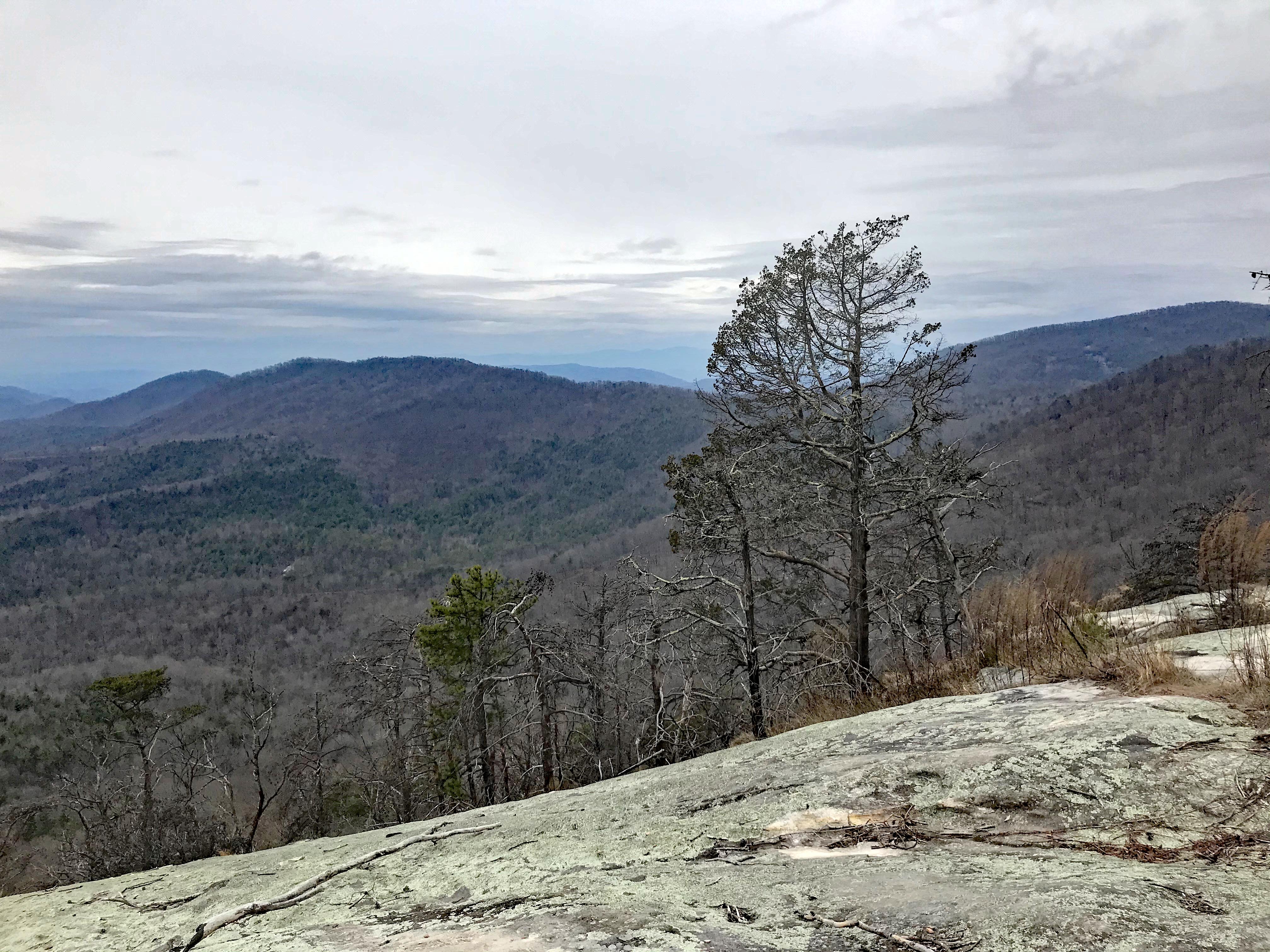
Do not let the lower elevations fool you; this trail is not easy. Per my GPS watch, I covered a total of 78.8 miles between the trail, a short detour, and wandering around campsites. Walking from Oconee to Table Rock State Parks, elevation gain was 15,433 feet and loss was 14,913. This worked out to an average change in elevation of 385 feet/mile. The AT, as a whole, averages a change of 237 feet/mile. At one point “Heartbreak Hill” climbed at a rate of 1,600 feet/mile. For me, the real heartbreak was giving all that climb back over the next half mile, then doing it all again. That is some great training for the PUDS (pointless up and downs) on the AT.
The footpath itself is well constructed and well maintained. The occasional flattish stretches are a joy to walk, but there is no getting around the power of gravity on the hills.
Even in the damp spring, I was able to rock hop any creek that wasn’t already bridged.
Getting There
The trail can be hiked in either direction, though starting at Oconee State Park puts off the biggest and steepest hills until the food bag has lost much of its weight.
Oconee State Park from Atlanta: take I-85N to US 76W to US 28W to State Park Road.
Table Rock State Park from Ashville: take I-26S to US 25S to SC-11S to park entrance.
Shuttles can be arranged through both local outfitters and a list of volunteer drivers. Both can be found at the Foothills Trail website. Overnight parking is available at either end by paying a $5/night parking fee.
Water

Like much of the southern AT, water is plentiful. There are numerous streams, impressive waterfalls and a large lake along the route. The Foothills Trail Guidebook points out all water options and I rarely carried more than a liter at a time. As always, filter any water before drinking it.
Climate and Weather

First wildflower of the season – March 2.
The Foothills Trail is not significantly farther north and generally stays 1,000 feet or more lower than the AT does through Georgia. Nearby Pickens, South Carolina, averages a low of 30 and high of 52 in January. By watching the weather, the trail can be hiked in late fall, early spring and even through the winter; perfect for that decision-making tune-up hike. Rainfall totals 53 inches annually and is spread evenly through the year. Snow is rare and typically doesn’t last. Even on Mount Sassafras, less than 9 inches of snow falls in a typical winter.
During my hike, there was a cold snap that brought nighttime temperatures down near 20. Even with that, the days were pleasant.
On the other hand, summer hiking can be hot, humid, and buggy.
Camping

Overlooking the upper reaches of Lake Jocassee.
This is one area where the Foothills Trail and the AT differ significantly. There are 262 shelters on the AT. Other than one small “emergency” cave, there are none on the Foothills Trail. Bring the tent or hammock. There are a number of great spots to camp, though, many designed and built as Eagle Scout projects. Nearly all have flat spots for tents, a fire ring, and a nearby water source. Quite a few have benches and provisions to bear bag your food. I hit the jackpot camping along Lake Jocassee. Gorges State Park maintains campsites with sand tent pads, grills, and picnic tables. Within the national forests, camping is permitted throughout and there were no fees at any of the locations I camped.
The other main difference is that in early spring the Foothills Trail is not crowded with campers. I camped alone at 3 of 4 locations and actually went two full days without seeing another person.
Resupply Options
As a training hike, be prepared to carry all the food needed for the trip. It is possible to cache supplies near a road crossing, but it complicates logistics significantly. Think of the trail as a “short” 100-Mile Wilderness.
Summary

If you’re not sure if you really want to hike the AT, consider the Foothills Trail as a test. If you want to train for an upcoming AT attempt, keep the principle of specificity in mind and try a training hike on the Foothills Trail. Or, if you just want to get out in a beautiful natural area for an early or late season hike you can complete in a week, try the Foothills Trail.
Plan on spending 4-7 days on a well-designed, well-maintained, well-marked trail through some gorgeous, yet challenging terrain. The hike is not unlike the southern AT. The difficulty is similar. The surrounding forests and streams will seem familiar. The white blazes are typically easy to follow. The main difference I found was the lack of other hikers. If you finish this trail wanting more, there’s a good chance a successful AT thru-hike could be in your future.
Of course, for me, the best part of the trail was the seclusion and lack of shelters, so I’ll continue to hold off on the AT for now.
For additional planning information, check out the Foothills Trail Conservancy. In addition to a helpful website, they have created the official map of the Foothills Trail and a Foothills guidebook. At 7 ounces, the guidebook is a tad heavy, but includes maps and turn-by-turn directions in both directions.

This website contains affiliate links, which means The Trek may receive a percentage of any product or service you purchase using the links in the articles or advertisements. The buyer pays the same price as they would otherwise, and your purchase helps to support The Trek's ongoing goal to serve you quality backpacking advice and information. Thanks for your support!
To learn more, please visit the About This Site page.

Comments 15
The Foothills trail slammed full of people is no safer than the AT slammed full of folks. They’ve had a heck of a time keeping people out of the parks and forests as it is. Please don’t promote this as a safe alternative.
Brian,
Bless your heart…perhaps a new pair of spectacles could be appropriate?
Brian,
I agree with you 100% and was not promoting the trail as a hike to take now. In fact, to be clear: both endpoints and several other access points are now closed. This is NOT a hike to attempt until restrictions are lifted. As I stated in the article, it is a shorter hike to consider “once restrictions are lifted.” I only mentioned it being a “safer” choice “when life starts getting back to normal.”
Many readers of this website have cancelled hikes on the AT, PCT, or CDT. Even if things get back to normal in the most optimistic time-frame, it will probably be too late for them to take a 2,000 mile hike this year. My thought process was they might be looking for options to consider for a shorter hiking experience (again) “once restrictions are lifted.” At that point, The Foothills Trail would remain a good option to train for or simulate an AT thru-hike; even if that thru-hike is pushed off to 2021.
Try the Foothills/Conservation Trail in New York State. From the Hudson River west to Erie,PA. It basicaly follows US Rt. 86. along the old toll road which along the bottom of the the many Finger Lakes. You’ll love it. Very beautiful.
Sounds like one to check out, thanks.
Is this different than the finger lakes trail?
I believe a portion of the Conservation Trail is also considered to be part of the Finger Lakes Trail
Jim:
Your point is clear to me. I hiked this trail last April and it is indeed a great choice. I found the section from Lake Jocassee to Upper Whitewater Falls to be very enjoyable and challenging. And, as you indicated water is plentiful. I never carried more than liter. Plus, great campsites along the trail.
I wasn’t expecting so many great campsite options, so that was nice plus to the hike.
Hi Jim – great article and I love to see the Foothills Trail get some attention! I first found out about the trail more than 10 years ago and am part of a group that runs it – I’ve had many life changing experiences on it. Great advice to folks about hiking this trail as an alternative or training hike for the AT. And in all the times I’ve been on it, aside from areas around the parks and other major access points (Sassafras and Whitewater Falls), you rarely see more than a handful of other hikers because it’s so secluded. Thanks!
Thanks for the comments. It was a great hike while being challenging and secluded.
Good article about an excellent trail. Thanks to Jim for writing about it, and thanks to Charles for being a part of the group that takes care of it. Some buddies and I hiked the Foothills Trail last year in late spring. It was challenging and fun. There’s just no downside to it, and I’ll go back to it again in a year or two once the current mess abates. This is one that should be on everyone’s list if you live in the southeastern US.
Good article. Just finished section hiking the AT. The Foothills Trail sounds great.
Thanks, it’s definitively worth checking out if you like the AT.
Great article. The Make a Wish organization holds their Trailblazer Challenge along the last 28 miles (from Whitewater Falls to Oconee State Park) several times a year. I’ve definitely enjoyed my time there.