 ">
">
A Modern Day Threat to the AT: The Proposed Mountain Valley Pipeline
I was driving down my country road recently to go check out hiking trails just south of the Appalachian Trail near Blacksburg, Virginia and enjoy the fall colors. On my way I passed multiple large signs along the sides of the road stating “Entering Blasting Zone” and “Exiting Blasting Zone” – evidence of my community fighting back against the Mountain Valley Pipeline (MVP), a proposed $3.5 billion dollar pipeline that would extend 301 miles from West Virginia through northwestern and central Virginia.
Seconds later I passed a group of surveyors doing their job for MVP – analyzing private land where the proposed Mountain Valley Pipeline would run through my neighbors’ property. I knew many of the facts concerning the proposed pipeline but seeing the work already in action (even prior to approval of the pipeline by the Federal Energy Regulatory Commission) and the surveyors there in the flesh made my heart drop and tears form in my eyes. The possibilities of ecological devastation, blighted viewsheds, and contaminated water sources in this beautiful area of rural southwestern Virginia was real.
This is my home. This is where I grew up in one of the most gorgeous areas of Virginia. This is the home of the iconic “Triple Crown” of Virginia – Dragon’s Tooth, McAfee’s Knob and Tinker Cliffs – all of which are significant overlooks on the Appalachian Trail. This is a place rich in resources, Appalachian settlers history, and an area through which thousands of hikers pass each year; the Roanoke Appalachian Trail Club estimates that over 76,000 hikers and backpackers hike McAfee’s Knob annually. If approved, this pipeline has the potential to forever scar over 100 miles of land on or within sight of the Appalachian Trail where it would run over Peters Mountain and cross the AT.
View from Angel’s Rest – red arrow points to the location of the proposed Mountain Valley Pipeline on Peters Mountain
The proposed pipeline crossing also fails to meet numerous criteria in the Appalachian Trail Conservancy’s 2015 Policy on pipeline crossings. So far, Mountain Valley Pipeline has disregarded the recommendations from the Appalachian Trail Conservancy (ATC) with regard to the least damaging route across this unique national park. MVP’s lack of respectful cooperation is unprecedented in the history of the ATC; according to the ATC, FERC has issued a “severely deficient” Draft Environmental Impact Statement (DEIS) for the pipeline’s impact on the Appalachian Trail and must be revised.
Those of us who love the AT know about these places and have likely taken a photo on McAfee’s Knob or gorged ourselves silly at the Home Place just down the road. The proposed route for this pipeline would cross the AT near Pearisburg, Virginia but it doesn’t mean that Pearisburg could be the only town potentially affected. As lovers of the trail I hope to share with you some information regarding this pipeline so you can come to your own conclusions and Take Action.
What is the Mountain Valley Pipeline?
The Mountain Valley Pipeline is a proposed high pressure natural gas pipeline that would run from Wetzel county, West Virginia to a processing station in Pittsylvania County, Virginia spanning 301 miles of public and private land. Mountain Valley Pipeline, LLC has been contracted to do this work for various energy companies including EQT Midstream Partners, NextEra US Gas Assets, WGL Midstream, and Vega Midstream MVP. The company has the power (issued by the federal government) to use eminent domain to allow construction on both private and public land. The pipeline has not been officially approved just yet with the Federal Energy Regulatory Commission (FERC) having the last say in the approval process. However, this decision is scheduled to happen early in 2017. Although the energy companies are touting an increase in jobs and gas supplies for the region to secure the welfare of the public, developers and financers of Mountain Valley Pipeline have already indicated that some of this fracked gas will be exported to foreign countries, all of which provides profits for private investors.

Why is this a concern for the Appalachian Trail?
- Ruined Viewsheds
The Mountain Valley Pipeline is proposed to cross the Appalachian Trail near Pearisburg, Virginia on Peters Mountain. There are many popular hiking spots on the Appalachian Trail near Pearisburg including Angel’s Rest, Rice Field Shelter and Kelly’s Knob. There are 19 potential locations on the AT where the Mountain Valley Pipeline corridor could be seen including as far south as Angel’s Rest all the way to Dragon’s Tooth and even McAfee’s Knob. The Federal Energy Regulatory Commission (FERC) which is in charge of assessing the environmental impact of the pipeline has proposed amendments to the Land and Resource Management Plan for the Jefferson National Forest to allow for pipeline construction and future expansion. One such amendment proposes that the Scenic Integrity Objective for the Appalachian National Scenic Trail be reduced from High to Moderate in this area.

Visibility Study on the Appalachian Trail for the MVP.
Red = up to 15.6 miles visible; yellow = a mile or less.
Black = pipeline route
Green = Appalachian Trail - Fragmentation of Forest Habitat
Mountain Valley Pipeline could end up being part of a proposed 500 ft wide “utility corridor” containing multiple fuel pipelines, as well as other utilities – almost 2 football fields wide. This threat is contained in a proposed amendment to the Jefferson National Forest LRMP (Land and Resource Management Plan) presented in the Federal Register/vol.81, No.199/Friday, October 14, 2016/ Notices. What this portends for the AT is currently unknown, but very worrisome given the very close proximity of the AT to the section of Forest Service land addressed in the amendment. These proposed amendments can be accessed Here from the Federal Register.The utility corridor is an area where all trees will be removed to allow for the pipeline and many access roads will be built near to allow for construction and maintenance. This could also mean an increase in noise disturbance for areas surrounding the construction sites including the AT. There is also an area of old growth forest the pipeline would be crossing and current Forest Service rules do not allow the removal of old growth forest; however, Mountain Valley Pipeline has proposed this as an amendment to the forest plan to allow for construction. As stated by the Appalachian Trail Conservancy guidelines, a proposed pipeline can only cross the AT at a “point already subject to significant impact”. The ATC points out that the current proposed crossing is a location of “unbroken wild landscape” of forest, rocky outcroppings, and grassy balds with no previous impact making this an unsuitable area for the pipeline to cross the AT.
A simulation of the 500 ft corridor proposed by the Mountain Valley Pipeline in Giles County, VA. Credit: Roanoke Valley Cool Cities Coalition
- Contamination of Watersheds
The Appalachian mountains boast a rich and diverse ecology of forests, streams and farmland and is an area rich in karst terrain – a landscape formed by the dissolving of limestone creating numerous caves, channels and sinkholes beneath the ground. The proposed corridor of the Mountain Valley Pipeline passes through a significant area of this unstable karst. The resulting underground waterways end up being very interconnected which means that any disruption, pollution or sedimentation in one area can be easily transferred to another distant area by the means of this underground network. Tracer dye studies done on deep wells in this section of Virginia prove that large areas, including multiple counties, are linked by this fragile subterranean system.A leak is so dangerous for a watershed such as ours because of the nature of fracked gas and the chemicals used to extract it. In-pipe contaminants may include: hydrocarbon condensates; lead which may deposit as radioactive 210Pb, a transitional product of radon (222Rn) decay with a half-life of 22 years; heavy metals (such as mercury and arsenic); other naturally occurring radioactive elements; and unidentified fracking chemicals that companies legally do not have to report. The gas is also transported under intense pressure (1,400 to 1,500 pounds per square inch) which means leaks are serious and after the pipeline is abandoned, it will begin to corrode and slowly release this toxic sludge into the ground. The proposed Mountain Valley Pipeline is 42 inches in diameter, which means it is on par with large lines being built in the midwest and has much more surface area for leaks and corrosion.
Representation of a 42″ diameter pipeline. Credit: Roanoke Valley Sierra Club
Moutain Valley Pipeline has secured a 20 year contract for this pipeline from it’s energy partners, however, it is unclear whether MVP can maintain this supply of natural gas. Natural gas is a finite resource and there have been multiple studies recently that indicate signifcant uncertainties regarding the lasting production of natural gas in the Marcellus shale region. Furthermore, Mountain Valley Pipeline currently has no plan for post-abandonment closure or hazard mitigation. The Virginia Chapter of the Sierra Club recently wrote to FERC addressing their concern in the lack of post-production maintenance considering the eventual closure or possible abandonment of the project. Without an accurate plan for post-production, corrosion of pipes and possible leaks is of great concern. It is unclear how such contamination would affect the water used by hikers in the area but given the interconnectedness of this special terrain it is highly likely that a small spill (even of diesel fuel during construction) in one area could have a far reaching impact on AT water sources.
- Erosion and Landscape DisruptionNot only does karst link underground waterways, it is also a very fragile landscape to build upon as it is both unstable and unpredictable. Both surface and subsurface environment is more easily degraded in karst than in most other terrains, especially in the mountains, and Appalachian karst poses a significantly greater hazard than other lower topographic areas. A study published on July 3, 2015 (“An Expert Report on Geologic Hazards in the Karst Regions of Virginia and West Virginia” by Ernst Kastning, a recognized expert on karst geology) concluded that the route proposed by Mountain Valley Pipeline should be considered a “no-build” zone based on it’s karst dominated terrain.

Erosion from a 12″ pipeline in Giles County, VA
This area is also located near the center of the Giles County Seismic Zone, the scene of the largest earthquake in Virginia history and is still considered an active zone. The ridges and slopes of the mountains where construction will happen are also at grades exceeding 40% and even 60% meaning they will be prone to disruption and erosion. According to Mountain Valley Pipeline, 225 miles of the 301 mile route has landslide potential. The current plan is also allowing the violation of existing Forest Service standards regarding soil and riparian (river) conditions for Mountain Valley Pipeline.
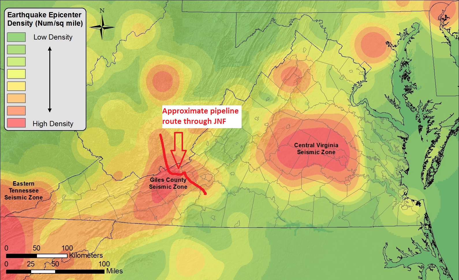
Virginia Seismic Zone and Proposed Mountain Valley Pipeline route
- Safety Hazard for HikersThe Roanoke Appalachian Trail Club has stated that the proposed crossing on Peters Mountain would “present a significant safety hazard to AT hikers” citing the highly volatile natural gas under pressure and the karst topography and seismic zone for the region. The “blast zone” for the proposed pipeline is 1,000 feet on each side and a minimum “Evacuation Zone” is 3,600 feet. AT hikers on Peters Mountain would need to walk miles on steep terrain to evacuate to the closest road which is Pocahontas road, however, this route would actually take hikers closer to the pipeline rather than away from it. The Groundhog Trail, which provides access to the West Virginia side, is over a mile way creating no sensible evacuation route. If a serious accident were to occur during construction or after implementation, the risks are many including severe burns from fire or chemicals. Presently there has been no consideration for hiker safety in selecting the location of this pipeline.
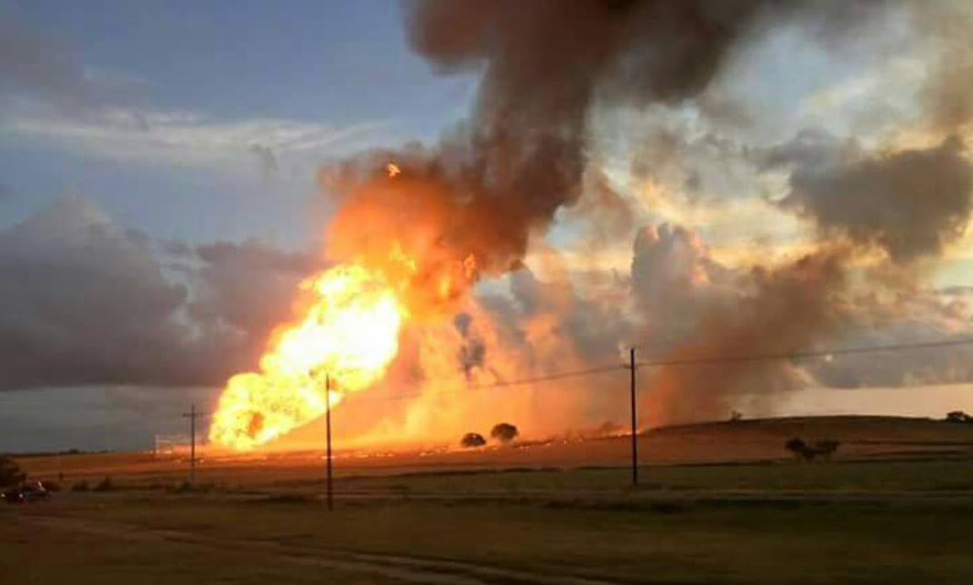
42-inch natural gas pipeline explosion in Cuero, TX on June 14, 2015.
What Can You Do?
The most important thing is to Educate Yourself. If you decide that you oppose this pipeline – please Take Action and go to the ATC’s page on the Mountain Valley Pipeline and follow the steps they have outlined. The ATC has provided the clearest means of action that citizens can do at this time, including submitting a letter directly to the Federal Energy Regulatory Commission and others steps for action.
Here are other important resources for information and community organizations that need your help:
- Preserve Montgomery County VA
- Appalachian Mountain Advocates
- Protect our Water Heritage and Rights
- Roanoke Appalachian Trail Club
- Preserve the New River Valley
- Roanoke Valley Cool Cities Coalition
It is also critically important to review information given by Mountain Valley Pipeline and hear the other side. Here are a few resources regarding this multi-billion dollar project:
- Mountain Valley Pipeline
- The Federal Energy Regulatory Commission’s Draft Environmental Impact Statement for Mountain Valley Pipeline
- Amendments to the Land and Resource Management Plan for the Jefferson National Forest
It goes without saying that pipelines are a hot issue right now and the Mountain Valley Pipeline shares similarities with other proposed fracked gas and fossil fuel pipelines across the nation. We are seeing how problems with these pipelines are constant – explosions, leaks, fires – and are continuing to wreak havoc on small towns, rural and urban areas, watersheds and air quality. These issues are not going to simply go away and with the current political climate concerning the environment, we do not know what the future holds.
As a lover of the Appalachian Trail and former thru-hiker I am deeply concerned about the potential impacts that this pipeline could have for the small towns the AT helps to support in southwestern Virginia. It is also very concerning for future hikers. If you’ve thru-hiked the AT or done most of the Pennsylvania section you will probably remember the Superfund site up near Palmerton, PA, a former zinc smelting site. In AWOL’s guide you are given warning about possible high metal content in the streams nearby. Many of us probably thought that would be the only time we walk through a Superfund site on the AT and how I wish that could continue to be a truth. However, with ten different pipelines being proposed to potentially cross the AT in 2015 alone according to the ATC, the safety of this beautiful trail is in a very vulnerable position and could ultimately be jeopardized.
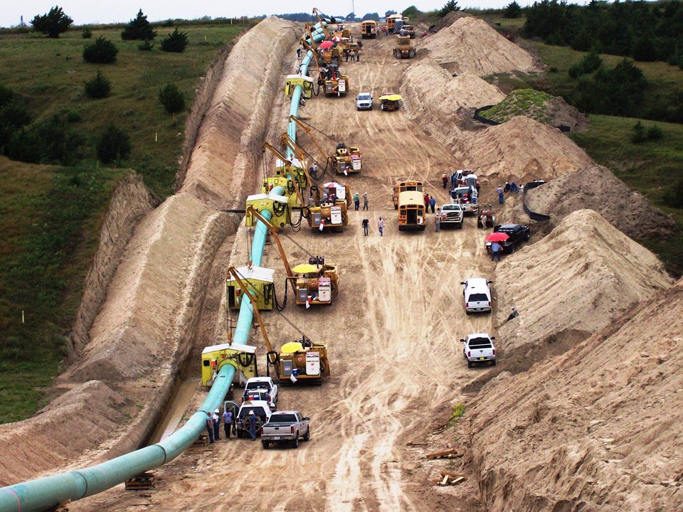
Construction of a 42″ diameter pipeline in Nebraska.
I urge you to do the research yourself, come to your own conclusions and take the appropriate steps to voice your opinion. The ATC has outlined the clearest way to take action at this time if you do not want this pipeline to be built on Peters Mountain. They also have set up a space for comments, concerns and questions on their webpage. Putting our effort into fighting this pipeline might be one of the greatest acts of trail magic we could perform to help our future hikers. We must all do our part to ensure that the Appalachian Trail is a rewarding experience for everyone and continue to protect this trail we love so much.

This website contains affiliate links, which means The Trek may receive a percentage of any product or service you purchase using the links in the articles or advertisements. The buyer pays the same price as they would otherwise, and your purchase helps to support The Trek's ongoing goal to serve you quality backpacking advice and information. Thanks for your support!
To learn more, please visit the About This Site page.

Comments 4
I have been involved in #noDAPL.
I recommend photos of burst oil pipelines.
These oil pipelines were signed off by Obama, witout local environmental and fish and game reports, in violation of our law.
The oil is forced out of the ground, by fracking, and the natural gas and gasoline that floats on the oil deposits is burned off, unused.
These oil pipelines are not Trump “energy independence” for USA.
The oil is quickly removed to ports, and exported.
The oil pipelines move heated oil under pressure, and burst.
There is no provision for detecting pressure loss at intervals, with cut-off valves, to protect the environment.
This is true for DAPL. This is true in Arkansas.
I would be surprised if this isn’t true here.
I suggest write Trump. This is not “energy independence” for USA.
It is extraction of our oil as rapidly as possible, and our U.S. Navy is the biggest end-user of gas and oil.
These oil pipelines are a plan that will leave us high-and-dry.
Connie – this proposal is for a gas pipeline not oil. Your post confuses the issues. I am against this pipeline but for other reasons than what you are stating.
[email protected]