 ">
">
Albert Mountain and the First Hundred Miles
I won’t lie, hitting the 100-mile milestone was a natural and literal high.
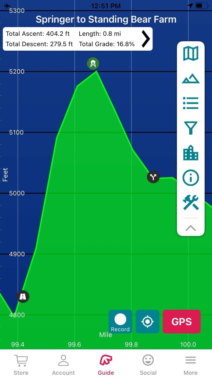
From the FarOut app, this graphic put some serious fear into my soul.
The day I climbed Albert Mountain, el. 5,200 feet, I awoke to a steady rain on my tent.
Great. I don’t want to do this climb in the rain. What now?
Frustrated, I texted my husband. I needed to vent. This climb is iconic and I didn’t want to bypass it.
I grabbed my AWOL guide and noticed a bad weather alternate route around the summit. As much as I wanted to climb Albert Mountain, I also didn’t want to end my hike due to an injury on the steep, rocky ascent.
I made a mental note about the bypass trail and decided to reassess when I arrived at the decision point.
As I climbed out of Mooney Gap, the forest of rhododendron (not yet in bloom) opened occasionally to reveal views of neighboring mountains. The rain stopped. Thick fog that enveloped the gap began to give way to occasional shafts of sunlight.
At the very moment I arrived at the bad weather bypass, a breeze picked up and the sun shone on the mountain.
Well, there’s my sign.
I texted my husband one word: Climbing.
While the trail maintainers had done a great job installing “steps,” logs and rocks strategically placed to aid in the climb, the challenges came when scaling boulders the size of a compact car.

I know the photo doesn’t really show how steep this climb is. Check out the white blaze on the boulder at about 11 o’clock.
Is this really the trail?
Yep, the white blaze on the boulder confirmed it.
What the heck is this ladder-like thing?

Albert Mountain “ladder”
Set on an angle, it spans an un-climb-able section. Chicken wire on the rungs kept my boots from slipping.
At long last, I emerged onto a less steep section of trail bordered by small bushes. Then, the summit!
The summit is actually about a half mile shy of 100 miles, but that didn’t stop someone from writing on the fire tower, nor does it stop every thru-hiker from taking a photo there.

Every hiker takes this same photo, but that doesn’t make it any less meaningful.
I dropped my pack and climbed the tower.
Unfortunately, the former-live in quarters at the top of the tower were locked, but the tower’s metal stairs and lower landings were open. I went as high as possible and enjoyed exceptional views in all directions.
A little further down the trail, I came to two 100-mile markers—one in sticks and one in stones. Because the trail distance changes slightly each year, the 100-mile marker moves as well. According to the FarOut app, the marker of sticks was right on the 100 miles.

100 miles in sticks

100 miles in stones
Here’s to reaching triple digits and knocking off one more milestone!

This website contains affiliate links, which means The Trek may receive a percentage of any product or service you purchase using the links in the articles or advertisements. The buyer pays the same price as they would otherwise, and your purchase helps to support The Trek's ongoing goal to serve you quality backpacking advice and information. Thanks for your support!
To learn more, please visit the About This Site page.

Comments 2
Carol is from my hometown and everyone is pulling for her to get to Maine. I envy her tenacity in just doing this to start with……..! Be careful out their !
Thanks, Carlos!