Appalachian Trail State Profile: Virginia
At over 550 trail miles, Virginia is the longest state on the Appalachian Trail. Hikers reach the state line at mile 466, three miles before Damascus, and most will be in Virginia for a month before reaching the West Virginia border at mile 1,007. For hikers who have become accustomed to checking off state lines as milestones in their journey, Virginia can be somewhat of a buzzkill. The Virginia Blues are less attributed to the state, and more where many hikers land in their relationship to the trail. The honeymoon phase is over, but NOBO hikers have well over 1,000 miles left in their journey. It can be a lag time, but keep a good attitude and enjoy all this state has to offer. But if you change your mind-set from crossing state lines to just enjoying the varied landscape and dozens of landmarks, this state is unforgettable.
Terrain
Well, it’s not flat. Virginia’s terrain can be broken up by region, and it varies from one end to the other. Southern Virginia is challenging, characterized by long, steep climbs and descents over ridge lines. Shenandoah National Park is one of the most gentle, rolling sections of trail, and northern Virginia is filled with farmland and rolling hills. 
Highlights
Mile 469: Damascus
Known for its hiker-friendly atmosphere, the AT passes right through this charming hub. Home to the legendary hiker festival of Trail Days, during which hikers either aim for Damascus or try to get as far away as possible.
Mile 469: Mt. Rogers Outfitters
Friendly local outfitter with full-service goods, including food, fuel, and gear
Mile 469: Woodchuck Hostel
Voted one of the 2016 best hostels on the Appalachian Trail, Woodchuck is dog-friendly, runs a daily shuttle to the grocery store, and has all the amenities a dirty hiker could want.
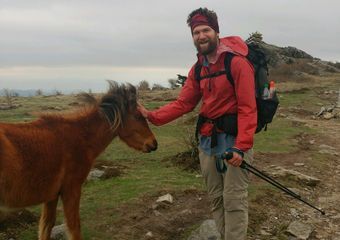
Mile 500-504: Grayson Highlands

Photo: Kylie Torrence
Grayson Highlands State Park is best known for the friendly wild ponies that roam freely within its boundaries. Lucky hikers will get close encounters with these little horses and perhaps a foal or two.
Mile 542: Settlers Museum
This open-air museum is set on 67 acres, and the AT passes right next to the one-room Lindamood School from the late 1800s.
Mile 545: The Barn Restaurant
Right off the trail in Rural Retreat, Va., this restaurant serves a 16-ounce Hiker Burger. Who could say no to that?
Mile 569: Chestnut Knob Shelter
This fully enclosed stone shelter will protect from the wind while being a prime location to view sunset and sunrise.
Mile 611: Dismal Falls

Image via
Take a lunch break at this peaceful cascading waterfall. This is a popular location for local day hikers.
Mile 678: Keffer Oak

Photo: Mischa Egolf
The second-largest tree on the Appalachian Trail, second only to the Dover Oak. The Keffer Oak is 20 feet around and 300 feet tall.
Mile 701: Dragon’s Tooth
Rocky monolith just a short side trail from the AT. Intrepid hikers can climb to the top and look out over the valley.
Mile 703: Four Pines Hostel
Voted one of AT hikers’ favorite hostels two years in a row, this donation-based hostel is just over a quarter-mile from from the Newport Road crossing, in a retrofitted three-bay brick garage with bunks and showers.
Mile 709: Homeplace Restaurant
Voted one of the best restaurants on the AT, this restaurant serves homemade meals family-style. Heaping platters won’t let a hiker leave hungry at this Catawba staple.
Mile 713: McAfee Knob

Photo: Pete Bromen
One of the most iconic spots on the Appalachian Trail, this rock feature stretches out over the valley and is the most photographed spot on the entire trail
Mile 718: Tinker Cliffs
Amazing views abound during this half-mile stretch along the edge of the cliffs. This is the third leg in the “Triple Crown” of views from this section of Virginia, preceded by Dragon’s Tooth and McAfee Knob.
Mile 785: James River Footbridge

Photo: Maggie Slepian
The longest footbridge on the AT. Some hikers choose to jump from the bridge into the James River as a classic AT bucket-list challenge
Mile 824: Spy Rock
One of the best campsites in Virginia, scattered with trees and close to incredible panoramic views for an epic sunset and sunrise.
Mile 828: The Priest
A challenging ascent in the Three Ridges Wilderness. This climb brings hikers to over 4,000 feet, followed by a 3,000-foot descent to the Tye River Suspension Bridge.
Mile 863: Rockfish Gap -> Waynesboro
Just a few miles off-trail, Waynesboro is home to Stanimal’s Hostel and Ming’s, a wildly popular AYCE Chinese food buffet.
Mile 863: Rockfish Gap Outfitter
Full-service outfitter located between Rockfish Gap on the AT and Waynesboro.
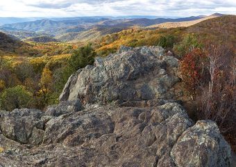
Mile 864-967: Shenandoah National Park

Photo: Ken Nail
Hikers enjoy mellow terrain with numerous crossings of Skyline Drive. You won’t have to carry much food through this section if you plan to stop at Waysides where you’ll find burgers, hot meals, and the famous blackberry milkshakes. Be bear aware through here. The bears are accustomed to hikers and might be looking for a snack from your food bag. Some hikers choose to aquablaze through this section.
Mile 970: Front Royal
A larger town full of restaurants, resupply options, and a natural-foods store. Hiker-friendly Pave Mint restaurant has all the large-portion options a hiker could want.
1004: Bears Den Hostel

Image via
Camping and bunk options, operated by the amazing Potomac Appalachian Trail Club (PATC). They sell a selection of food (including ice cream) and the stone lodge is a real stunner.
Mile 995-1008: Virginia Roller Coaster
13.5 miles of intense ascents and descents. This section is not to be underestimated, but hikers will appreciate the welcome reprieve of the Blackburn Trail Center afterward.
Mile 1012: Blackburn Trail Center
This beautiful establishment is also run by the PATC and is a low-cost place to stay for weary hikers finishing the Roller Coaster. Run seasonally by caretakers, they occasionally serve a donation-based dinner, and hikers can camp on the lovely center grounds.
See Virginia for Yourself
Video: Ashley Hill
Straight from the Thru-Hikers
Virginia has amazing sunsets and sunrises if you are willing to catch them. The state offers rolling hills and some challenging climbs. -Ashley (Savage)
Long as balls, but slightly easier than what NOBOs have become accustomed to. Were I to do it again, I’d absolutely road walk Skyline Drive. The Shennies are great, and I’d looked forward to them for weeks, but by the time I got there all I wanted to do was get through and take a zero or two with my friends in Front Royal. Also, the road is flatter and has better views. Hitting the 500-mile marker (written in pony poop) was a turning point for me. I stopped thinking about the difficulty of the trail, life off trail, and the miles left to hike and just kinda got into the swing of things. Less Virginia Blues and more Virginia Change of Perspective. -Rhys Hora
It is not flat, but it is unbelievably gorgeous. The rolling hills and green acres of old farmlands are almost too idyllic to be real. –Jessica “Ruby Cosmo”
It really is as long as everyone says. You have to divide it up into separates “states” to stay sane. We were SOBO, and did 1) Shenandoah, 2) Rockfish Gap to Pearisburg, and 3) Pearisburg to Damascus. -Keckeley “Scrunchie” Habel
Virginia Dispatches
Additional Info
Related
Thanks to Ashley (Savage), Rhys Hora, Jessica “Ruby Cosmo,”Keckeley “Scrunchie” Habel, “Turtle Traxx,” and “Soggy” for their input
This website contains affiliate links, which means The Trek may receive a percentage of any product or service you purchase using the links in the articles or advertisements. The buyer pays the same price as they would otherwise, and your purchase helps to support The Trek's ongoing goal to serve you quality backpacking advice and information. Thanks for your support!
To learn more, please visit the About This Site page.


Comments 2
Oh, lordy. Before I reached New Hampshire and Maine, Virginia was hands-down my favorite state. It’s still a solid No. 3.
Such varied terrain, so many unusual features and cool places to stay and eat and swim….
I think you nicely hit on all the highlights. But I would add Wood’s Hole, Stanimal’s and Quarter Way Inn hostels.
Thanks for the memories.
~Pony AT’16
Some responses:
Agree with Clay on Woods Hole. And Woodchuck is under new ownership since that 2016 survey – it may still be great, though. I loved staying there and getting to know Chuck when he owned it.
It is illegal to jump from the James River Foot Bridge, and police patrol it.
The description in The Priest has incorrect geography. Northbound, the AT descends from The Priest to the Tye River and then climbs to the summit of Three Ridges. The Priest itself is not “a challenging ascent in Three Ridges.”
Should add the Devil’s Backbone Brewery just north of Three Ridges – every thru-hiker I encountered hiking in the area in 2019 planned to camp there for the night and they provide shuttles. Then a long day to Waynesboro.