 ">
">
AT Day 94 – Made It To Maine
Androscoggin River to Mahoosuc Notch
General Tso Mosquito Camp to Dinner By Lightning Light Camp
AT miles: 18.4
Total miles: 1923.1
Elevation change: 6857ft gain, 5610ft loss
Aaaaall the way back, on Day 1 of this little adventure, a bearded man had yelled “MAKE IT TO MAINE” as Rooster, Crunchberry, and I disappeared into the mist after our lunch break at the hut on Springer Mountain. A few other randos had offered the same pep talk on my hike north, the most recent coming in Dalton (I can’t even remember what state that was in). At first it had seemed like a strange motto. Make it to Maine? Psht, I’m making it to Katahdin. However, the closer to Maine that I hiked, the more I felt the significance of merely reaching the final state of a northbound AT thru-hike. One can’t reach Katahdin without first making it to Maine, after all. And finally, as my pace slowed in the gloriously punishing White Mountains of New Hampshire, making it to Maine really did start to feel like the ultimate goal. It almost felt impossibly distant as I struggled up and over Moosulauke, the Kinsmans, Franconia, the Presidentials, Wildcat, Carter, and Moriah. Well, now I am here. I made it to Maine. And what does that mean, what does that feel like? The goal post has moved north, and once again stands planted on Katahdin. Besides that, I’ve learned that making it to Maine has really just earned me the biggest butt-kicking of my hiking career. And you thought The Whites were tough…
The morning routine got underway early in the peaceful protection of the van body. I was literally on trail, but somehow not until I stepped outside for the first time to pack my stuff. I looked up into a hazy sky, not sure if it was gray with cloud or with the monochrome of pre-dawn. Of course, pre-dawn had come and gone, I wasn’t starting that early, so it must have been a haze. The forecast was calling for a hot one, like 90F down in the lowlands, so I was eager to get back on trail and climb high into the relative cool if the mountains.

After a cup of coffee and the final mouthfuls of last night’s dinner, SpiceRack and I turned in the opposite direction of the trail, and started walking down a paved country road. There was still no update on the Centennial fire closure, so this was the alternate route that I had put together. For about a mile, we sniffed lilac and listened to the birds between songs that had been stuck in our heads for days. Then, next to a secluded home, a trail sign pointed me into the woods up the Peabody Brook Trail. I said goodbye to Spice, and dove in.

The Peabody trail was in great shape, and followed the brook up through tall pine, then vibrant beech, then dense spruce as it climbed to meet the Mahoosuc Trail on top of the ridge at Dream Lake. I made good time up the gentle slope at first, before slowing to my practiced White Mountain grind as the grade steepened without even considering a switchback. The morning was still relatively cool, but the dense humid air of the choked forest did little to evaporate my dripping sweat. I was soggy in no time.
I rejoined the AT proper at an unassuming junction. It was a relief to step foot back on the trail, my home, for I knew that it would take me where I was trying to go. It might not always play nice, but the AT runs from Springer to Katahdin, from Katahdin to Springer, as sure as anything else in this wild world. My alternate had been four pleasant miles, and bypassed nine miles of official trail. I’m no purist, although I strive to maintain a continuous footpath, but I did feel a little guilty about cutting some miles. But that’s what it takes on a thru-hike of this length. We do the best we can.
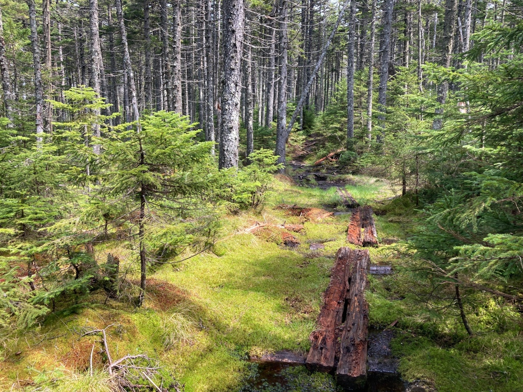
The trail from there wasn’t steep at all, but it was immediately challenging. Hidden in the smooth elevation profile were short boulder scrambles, slippery boardwalks, and deep mud holes. Each step was important and demanded conscious placement. Each one threatened to slip more or plunge deeper than I expected. But the forest was beautiful and full of life. Dense conifers, short and tall, cast deep shade, and I often couldn’t see the ground other than the trail for the needles and grabbing branches. Where there were gaps, thick mats of moss colored the floor different shades of fuzzy green, just asking to be touched. I enjoyed this hiking despite the slowness, but it was not a place that I would want to call home. To closed, not enough air.

The first big climb put me on the wide summit ridge of Mount Success. Open slabs finally allowed the slight breeze to cool my dripping sweat as I wondered at the first view of the day. It was a satisfying look back at the biggest mountains of The Whites, seeming more distant than they should have through the miles of humid sky. I recognized the shapes of many of them, but the details were buffed out like a watercolor painting. I sat on a particularly comfortable patch of granite and pulled food from my backpack. This was a good a spot as any for lunch as long as I used my umbrella to block the brutal heat of the sun.

Next stop, Maine. Two treacherous miles of bog and boulders did their best to extend my stay in New Hampshire to a life sentence, but I was having none of that. A slow section of cliffs and ice preceded a curiously easy wooden ladder, then I was there. At least that’s what the sign said. The spot was nothing special, except for the larger than average piles of moose scat, but the sun shone brightly and my spirit soared. Make it to Maine? Oh yeah, I made it to Maine. After a few minutes of fruitless contemplation and saying farewell to The Whites, I revved myself up, and charged into the final state, straight into a blowdown across the trail. It was an omen.
Difficult doesn’t even begin to describe the first afternoon in Maine. It was total mayhem. All the challenges previously described, the boulders, roots, mud, slabs, were present and amplified somehow. I was frequently faced with 5-10ft cliffs that all but brought me to a halt while I examined the face for enough texture to give my soles purchase on the weeping rock. I used my hands as much as my poles, and all were essential to keeping my butt off the rock and my face out of the mud. Even the short flat sections in between the slabby steeps were minefields of goo, eager to suck and slurp the shoes from my feet. Unless there was an actual rock to step on, there were no guarantees that my foot wouldn’t sink into two feet of ooze. Along the slippery boardwalks across the alpine bogs, the mud pits had no bottom. Each step was consequential, each pole tip placement carefully chosen. Slips were to be avoided. Slips were guaranteed.

A particularly cliffy section of trail provided iron rungs to reach the ridge of Goose Eye Peak. The trail was almost easy from there for about 100 yards before clambering up the next of the Goose Eye’s. From the open summit slabs, I took a breather to eat a bar, catch the breeze, and look around. I was in it now, standing in the middle of the long line of forested summits undulating from Mount Washington in the hazy distance to Old Speck ahead. There could have been smooth trail under the covering of trees, but I now knew better. Under this green blanket lay the most horrendous obstacle course of all time. However, I was surprised to notice that I didn’t hate it. Perhaps it was because I had been warned that Southern Maine was a bear. Perhaps it was the abundant sunshine. I would groan each time I saw another cliff in my path, yet I was indifferent to the whole experience. It was hard, and I noticed that without taking it personally.

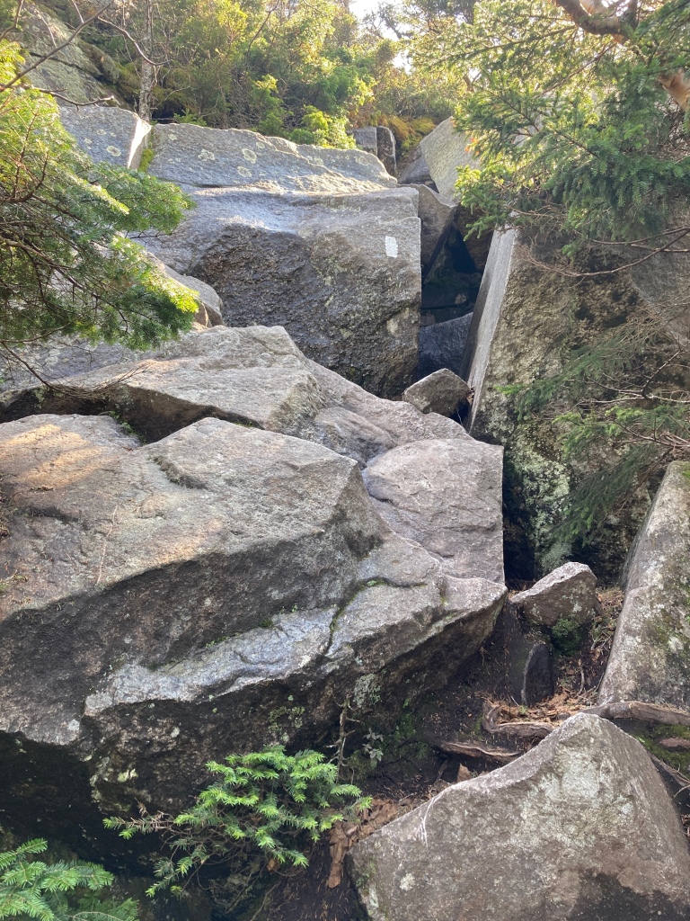
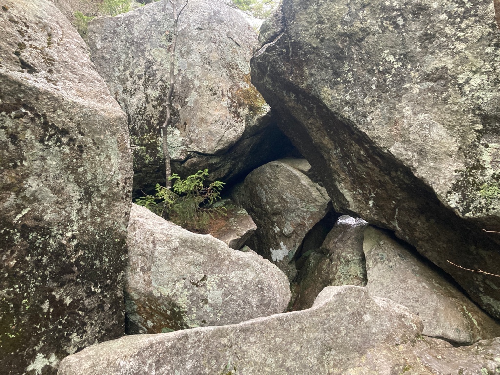
My fatigue grew close to my limit as I pushed across and over the North Goose Eye Peak. I was still grinding hard, hoping to make it through the notorious Mahoosuc Notch by nightfall before tomorrow’s rain could make it even more challenging. A long, quad-ripping descent deposited me at the bottom of the cleft between two huge cliff faces. Humongous boulders, up to the size of small homes, had come to rest in this mile-long narrow, and of course, the AT went straight through it.
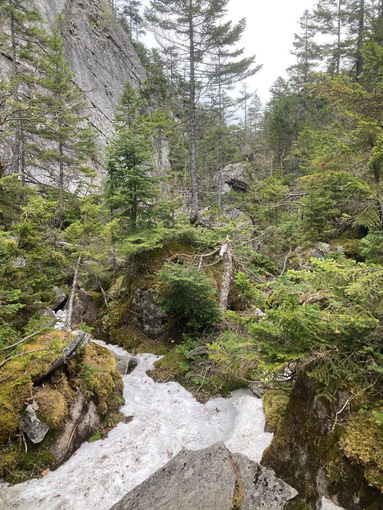
Tired, alone, and with darkness coming on, I was heading in against all better wisdom, but it was worth it to me to have dry rock. The temperature dropped 20 degrees instantly at the bottom, and it was easy to see why. Snow and ice still filled the gaps between the boulders. It was cold and supportive, and so might have actually aided my passage where it lay even though it was unsettling not to know if there was rock or air below. Only once did I almost slip into the narrow gap under a large boulder. The rest of the time, fun rock hopping and mild scrambling kept all four of my limbs engaged, and tested my balance. I felt good, practiced at this kind of thing at this point, and let the meditative concentration wipe away my conscious thought. I filtered water, and pushed my pack ahead of me through an icy tunnel or two. Then, an hour after entering the miracle mile of Mahoosuc Notch, I exited back into the warm evening, giving myself a pat on the back. Crushed it.
Flat camping was just a short distance further, and I pitched my tent not five minutes before the first rumble of thunder drifted to my ears. I hastily tossed all my gear inside as the first drops of rain began to splash. Just in the nickle time. I devoured a mixture of ramen and couscous as lighting flashed almost constantly for the next hour. Most of it produced no thunder, but the few claps that did rip the air were deafening. The rain came in waves, thrumming on my tent canopy like a drumroll. I’d never felt so tired and alive at the same time in my life, and I lay back, keeping my eyes open to the flickering of the storm long after it had moved from earshot. There was no place I would have rather been. This was Maine, this was home.
This post was originally published on my blog hikefordays.com. Check it out for trip reports from my other hikes including the CDT and Sierra High Route.

This website contains affiliate links, which means The Trek may receive a percentage of any product or service you purchase using the links in the articles or advertisements. The buyer pays the same price as they would otherwise, and your purchase helps to support The Trek's ongoing goal to serve you quality backpacking advice and information. Thanks for your support!
To learn more, please visit the About This Site page.

Comments 4
Dude, you are crushing those miles! You must be on track to complete in 4 months, that’s amazeballs! And your optimism, and realism, is always a breath of fresh air. Love reading your posts, perhaps someday I will see you out there! You should come back and do the whole Long Trail, after the Whites it would be a walk in the park! Happy hiking!
Following you via Trek to Maine has been inspiring, informational, educational and overall entertaining! It’s a shame you’re so fast!
Enjoy the rest of ME Owen the worst is behind you. Except the black flies.
Again dinner invite when Spicerack hikes SOBO.
Dalton, well, one Dalton is in Georgia. But probably not that one. It is west of Springer Mountain.
Awesome that you are in Maine.