 ">
">
AT Day 97 – Welcome To The Jungle
Sawyer Brook to Sabbath Day Pond Shelter
Big Time Beech Camp to Loon No Moon Camp
AT miles: 19.8
Total miles: 1967.5
Elevation change: 7175ft gain, 5771ft loss
Maine is a jungle. The forest is dense with life at every level, from the floor to the treetops, from moss to needle with leaf and flower in between. It is also a jungle gym at times, with varied terrain up the wazoo. The trail over the past two days has mellowed out considerably when compared with the Mahoosuc madness, but there are still dense thickets or woven roots to navigate and even iron bars to aid in the ascent or descent of the steeps. Maine has just been a crazy state so far. I never know what I’m going to get. A mile could be as easy as any, across flat stone slabs, or it could be the hardest yet as it wriggles up a thousand feet or more in seemingly zero distance. To match this craziness, the state feels wild and remote. It is clear now that as I hike further north, I leave behind the dense population centers of the East. I’ve moved beyond the human-dominated areas where people have shaped the landscape for generations, and where our influence is felt if not seen. The spirit senses this and comes alive to match the wildness of the northern wilderness. I see more moose tracks than boot prints, more mysterious peaks than homes. Even with a map, I feel like I’m walking off the edge of one. Maine is something else, the vibe is different, and I love it.
The snoozing was easy even in the bright sunshine of the early morning. I have little concept of when sunrise occurs these days, but it is certainly earlier than I want to be awake. I pulled my beanie over my eyes and rolled to face away from the glowing beech forest surrounding my tent. When I did rise to meet the day, not much had changed except that my belly rumbled and my bowls churned. Those were the ultimate alarm clocks. I knew better than to snooze those two sensations.
I was hiking by 8:45 a.m. and immediately took a wrong turn after crossing Sawyer Brook. It’s harder to see the white blazes through all the leaves, and it took some wallowing through bushes before I found the right path. There, all my morning enthusiasm ran smack dab into one of those steepest of the steep climbs. I worked my way up and up, fighting for each step, thinking that this was no way to start a day. At least it was cool under the dense shade of the beech leaves. The completeness of the sunblock was a new phenomenon, finally coming into its own after a month of budding potential. The morning was cool and my pack light, so I had a lot going for me. Still, the climb was a toughy.
Upon reaching the top of Moody Mountain, the trail tumbled right back down the other side. Again steep, again I moved slower than expected. However, waiting at the bottom for me were SpiceRack and Tango, who were worth the knee crunching. After a tricky river crossing, I dropped my pack and joined them inside Blackbird, where Spice loaded me up with a tremendous second breakfast of quesadilla, beans, avocado, salsa, and tea. It hit the spot but left me much too full to hike, so I lingered there, on the sunny side of the road, gathering my resupply and lounging in the sun like a lizard.
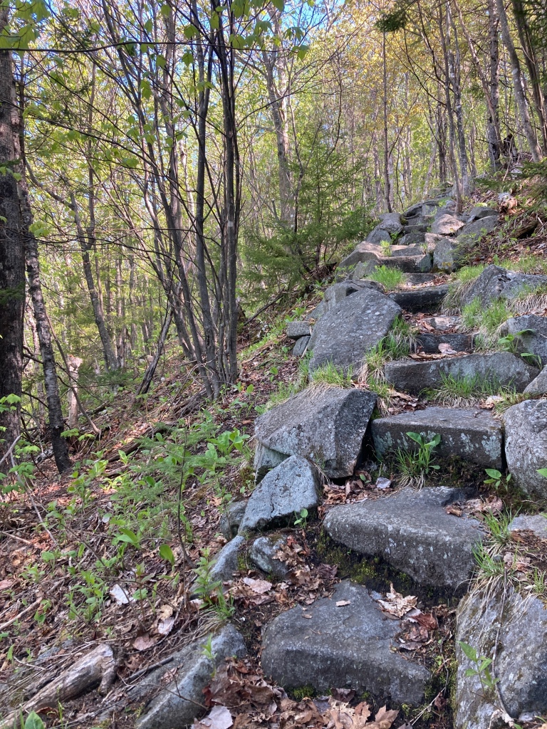
At 11:30 a.m., it was now or never. I broke free of the vortex, bidding farewell to the others and putting feet back on the AT. And guess what, another vertical ascent was waiting for me. This time, I sweated up Old Blue, moving slowly under a refreshed burden on steep steps and the occasional iron rung. A mile interlude of muddy flat divided the climb once the beech had changed to spruce, but then the up resumed, as steep as it was before. The trees shrunk as I climbed higher, and on the rounded summit, they were just short enough to afford a limited view back to Mount Washington, and everything in between. Was it worth it? Sure, why not.

A grueling mile later, I pulled over at a random bench with a view for lunch on the sloping lump of Elephant Mountain. The beans were wearing off and I needed something new to fuel my farts. It was a good sit in the perfect mixture of sun and shade, and I ate the perfect mixture of junk and healthy foods. My feet dried and my legs rested.
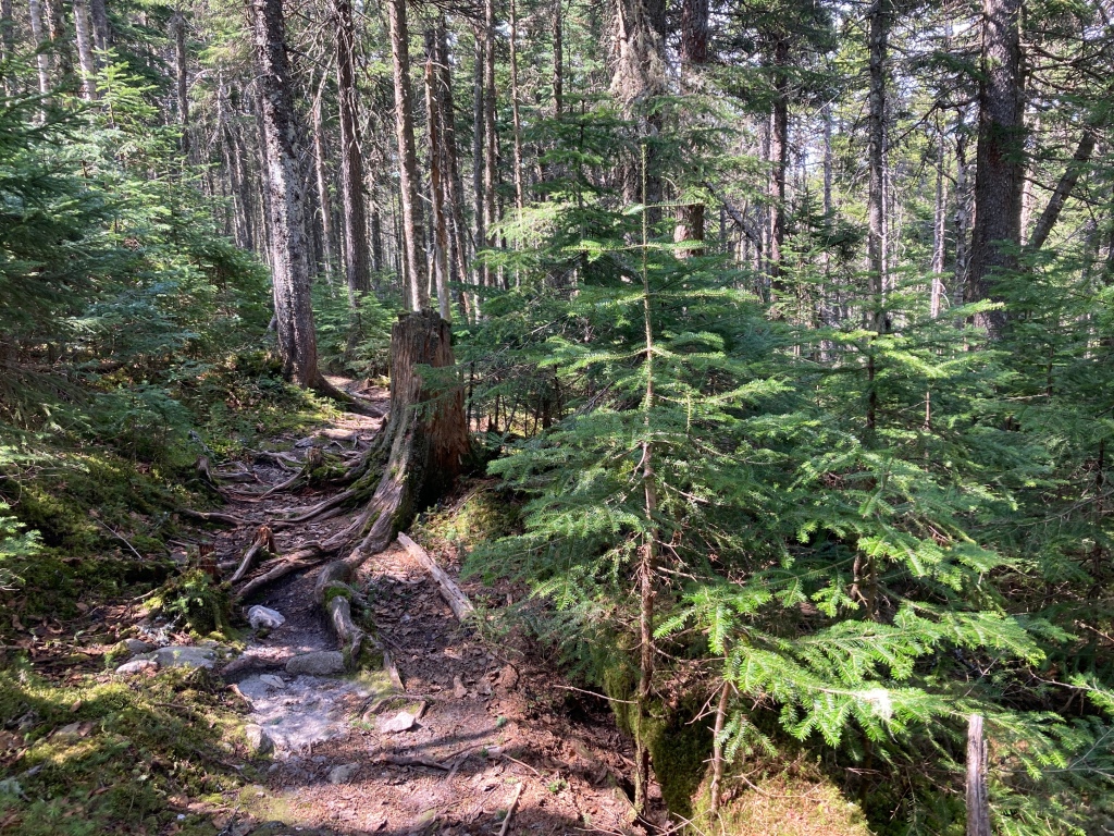
When I continued, it was through a narrow hallway of conifers and moss. It reminded me of a hedge or cornfield maze, and I was grateful for there being just one path to follow. It dipped and turned around unseen obstacles and folds in the earth, eventually bringing me up to the top Bemis Mountain. There were no views to speak of, just a sign telling me where I was, so I didn’t linger. I plunged back into the trees, dodging mud holes and ankle twisters with careful steps and mindful concentration. My ankles made it safe, but I dunked in more than my fair share of mud.

The second peak of the Bemis massif, was more air than tree. Cairns guided me along a sidewalk of exposed granite amid bald slabs and stunted pine rising out of ghostly white moss. Brief views peaked at me, but I was enjoying the speed of easy walking so much that I didn’t pay them much mind at first. However, a particularly open section gave me pause. The green mosaic extended as far as the eye could see, and only a single road betrayed the presence of humans, though I could hear that there were others. Engines roar louder than moose. Continuing down, I dipped back into the beechy lows, leaving the Bemisy highs behind.
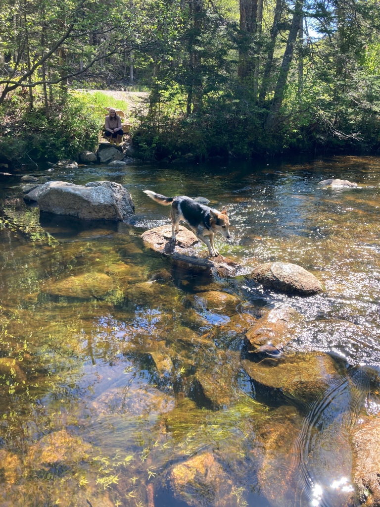
At the bottom, I just about kept my feet dry after an epic rock hop across a wide river. I was proud of the circuitous route and my balance until the second to last rock rolled over, leaving me shin deep. I was happy to be standing rather than sitting, but my feet were going to be wet for the rest of the day. I was so close to making it a whole day without a total soaking. Was I in Vermont the last time that happened?

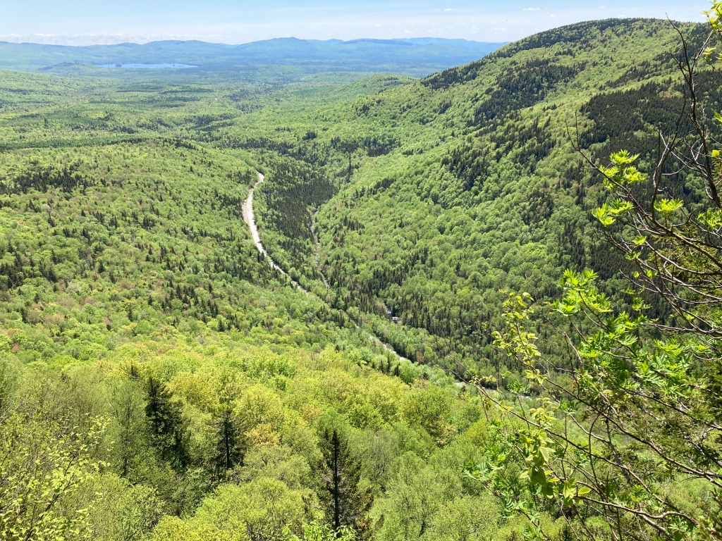
Another steep up followed, with more iron bars to help me up a short slab. Then I reached that road that I had seen from Bemis. Route 17 had a wonderful view of the southern mountains and Richardson Lakes. Not just that, but there was also a choice bench on which to perch while I gazed and caught my breath. The lowering sun hid behind some high clouds, which cast dark shadows on both sky and ground. The light was dramatic and wild, just like the landscape. I ate a bar, viewing, considering.

The final few miles around Long Pond were the easiest of the day. One might almost call them easy, although the footing was still treacherous at times with slippery bog logs and steep stone steps. I sniffed a campfire on the breeze and so was not surprised to find some campers at Sabbath Day Pond Shelter. Three generations were out for the night, and I chatted with the friendly Mainers until the last of dusk was fading to night. Quickly, I set up camp and filtered water by red headlamp, then got into bed, cradling my jar of soaking beans. Loons hooted their haunting call as what was left of the fire crackled and popped. It was an oddly comforting sound, and another point for Wild Maine. I might hear engines by day, but the loons and other creatures of the forest ruled by night. It was their time now. I rolled over and gladly let them have it.
This post was originally published on my blog hikefordays.com. Check it out for trip reports from my other hikes including the CDT and Sierra High Route.

This website contains affiliate links, which means The Trek may receive a percentage of any product or service you purchase using the links in the articles or advertisements. The buyer pays the same price as they would otherwise, and your purchase helps to support The Trek's ongoing goal to serve you quality backpacking advice and information. Thanks for your support!
To learn more, please visit the About This Site page.

Comments 5
Superb
Awesome ! Congratulations on your progress. Your personal insights and photos from the trail are truly inspiring. To look up into tthe trees and down on the clouds from above reminds us of the incredible beauty that is out there when we move beyond our comfort zones and challenge ourselves to see new horizons . I bow to your sagacity and thank you.
How do you check yourself for ticks. Like on your back and other places you can’t see?
Scenic AF is called the Height of the Land. And Long Pond is where several moose walked past my snoozing bivy at 5 am into the pond .. Was the canoe there?