 ">
">
AT Days 28-31: High Road Hits High Gear!
My enthusiasm continued to build as I moved into the New York section of the trail that would take me across the Hudson River towards Connecticut. My daily mileage also hit a four day high of 72 miles as I was really getting into a solid daily routine. Here’s the summary of these four days:
Day 28: Wildcat Shelter to William Brien Shelter (20 miles)
Day 29: William Brien Shelter to Graymoor Spiritual Life Center Pavilion (16 miles)
Day 30: Graymoor Spiritual Life Center Pavilion to RPH Shelter (19 miles)
Day 31: RPH Shelter to Telephone Pioneers Shelter (17 miles)
Going Big Towards Bear Mountain
I woke groggily after a not-so-great sleeping night on Day 28. You’re surprised? You shouldn’t be — after all, this was the night that followed a bear traipsing by my hammock as I described in my prior blog post. As my fellow shelter mates emerged that morning, I asked each of them if they had heard me yell “Go Away!” at 10:30 the prior night. Not a single one had – so I guess they all slept like rocks. Ah well, the downside of being a light trail sleeper. No wonder so many of them had no issue sleeping shoulder to shoulder each night in a wooden shelter.
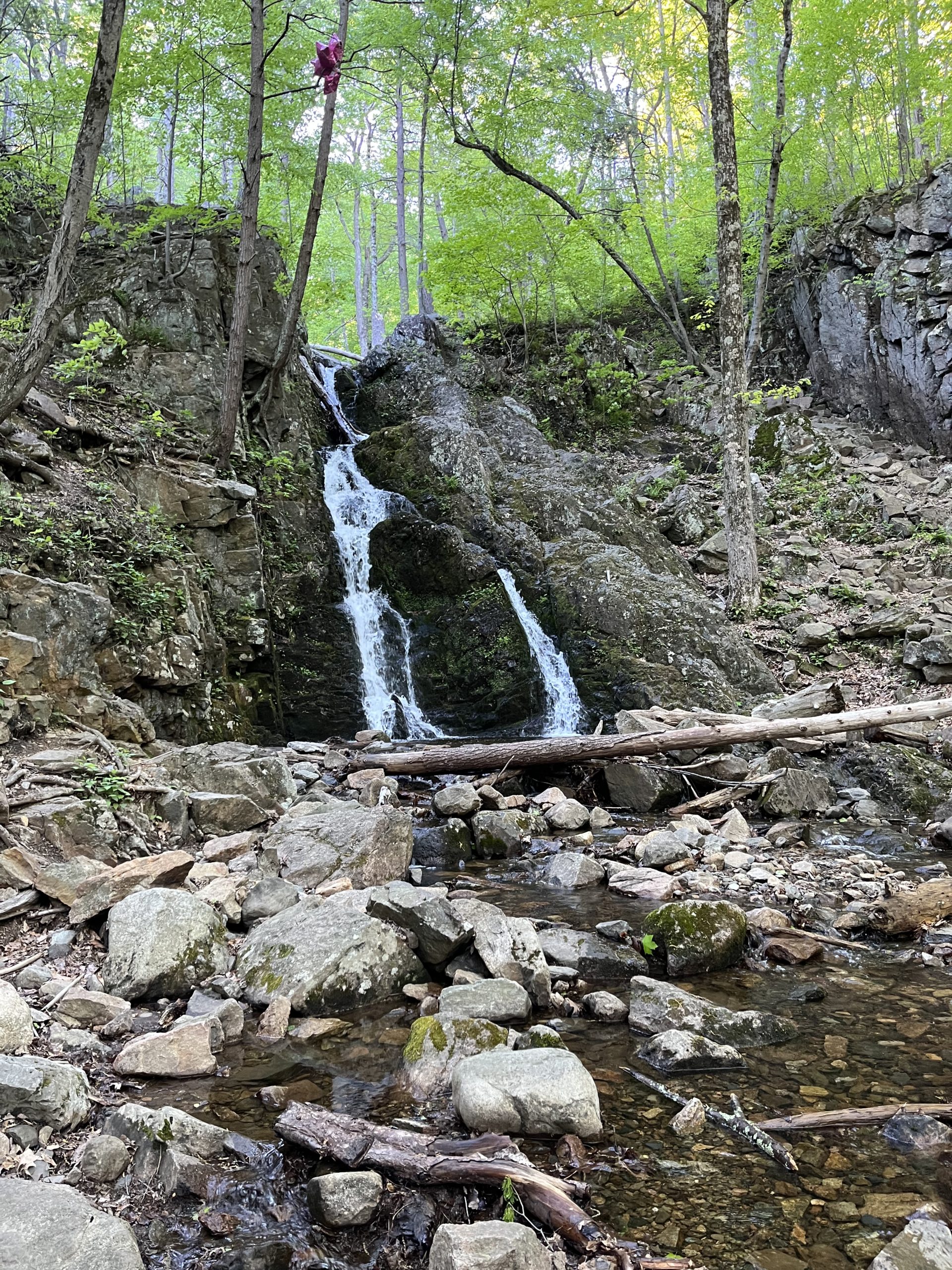
I don’t know if the bear incidents helped push me, but I really wanted to start putting in some big days. I’d logged three 12 mile days in a row due to resupply and weather concerns, and that was below my target mileage of 15-16 per day. Shooting for the Brien shelter would be a 20 mile day, so I went for it. The morning was cool and breezy – great hiking weather! I cranked out a really fast first six miles and was on my way. The nicest waterfall of my trip thus far was the Day 28 MMM – Most Memorable Moment:
I then encountered some fairly difficult rock scrambles, which New York seemed to have plenty of. But in some ways, it’s a bit of fun to go hand to foot up some impossible looking one hundred foot pile of huge boulders.
A whole catalog of head music was in full effect on Day 28:
- Godsmack’s “I’m Doing the Best I Can” kept rattling through because of my “Go Away!” command to the intruding bear the prior night.
- Bad Company’s “Movin’ On” rang in as I pushed to make my miles.
- And – out of nowhere – REO Speedwagon’s “Roll With the Changes” urged me to “Keep on Rolling”.
And I’m not sure exactly who the drunken sailor was that cut the trail between Wildcat Shelter and Harriman State Park, but it seemed to twist and turn without logic. Worse than that, it seems that a second drunkard was put in charge of painting white tree blazes along the same stretch. It was poorer blazemanship than I can ever remember seeing. (Is blazemanship a word? It should be …. in the same vein as “marksmanship” and “penmanship”, right?) You’d get two or three appropriately placed blazes, then begin a stop and peer around guessing game to find the next. My guess is the drunkard with the can of white paint was taking a swig from a hip flask at about that frequency. Numerous other hikers told me they had lost the trail multiple times in that stretch.
When I descended to the road to cross into Harriman State Park, trail magic happened to me for the first time in my trek! To explain to you non-hikers, this is when some wonderful person provides you food, beverage and other helpful supplies along the way. Fred, a volunteer member of the NY-NJ Trail Chapter, was there in person to give me a Gatorade, a delicious freshly made Ghirardelli brownie, and several much-needed Ziploc bags. He also provided some history of the park and its namesake. It was the Day 29 MMM! Here he is below. Thanks Fred and all of you others who provide trail magic!

Once into Harriman State Park, the trail and its markings were much improved. It was a beautiful day for hiking, as it was sunny but pleasantly breezy and cool.

I recognized that both Terrapin and Big Easy likely weren’t going more than fifteen miles today, so it didn’t surprise me that I was the only hiker staying at the Brien Shelter that night. Actually, it was a plus because the area surrounding the old stone structure had no good hammock trees, and some significant rain was on its way. So I stayed inside on a wooden bunk:

After a rainy night in the shelter, the morning was foggy with drizzle. I would be reaching the summit of Bear Mountain around midday, but the weather wouldn’t be ideal. When I started the final ascent, I actually entered low clouds. The trail cleverly leads hikers around all edges of the peak to various view points, but they were all in a deep mist. In fact, the conditions were so poor there were no cars at the top, and the observation tower was locked up! And this was at a location that other thru-hikers had described to me as “a complete zoo”!

The only hikers I’d meet heading up or down Bear Mountain would be two groups of about fifty boys each from a Judaic school. But the weather didn’t stop their excitement! Each group chattered like a group of five hundred kids! Additional school groups engulfed the park at the foot of the Bear Mountain Bridge, playing baseball and other field games.
Crossing the Hudson River
After running into Cosmo, a fellow flip-flopper that I had dinner with on Day 0 in Harper’s Ferry, I crossed the Hudson River on this seemingly endless bridge. Like my other road walks, it was not fun – especially with the added element of a several hundred foot drop to water below.

Another foggy morning hit on Day 30 as I departed the Graymoor Center’s baseball field and pavilion, which is available for thru-hiker camping. As I got back on the trail, I found that the evil Pennsylvania pointy rocks had returned (noooo!) in full force for the first four miles. However, then the Day 30 MMM showed up that morning in a very unexpected way.
I was crossing a small asphalt back road, and spotted a plaque about 30 feet off the trail. Upon inspection it was about George Washington during the American Revolution! An old foundation of about 100 square feet sat next to it. Who knew that Americans were doing inoculations against a potential epidemic back at the time of the revolution? I thought disease prevention of this type came into being later in history, but this article confirms the plaque’s statement. Wonder if they all had to mask up too?

The remainder of that hiking day was fairly rough. In part because the pointy rocks reappeared frequently throughout the day, but also because of a hugely disappointing hike around Lake Canopus. On the prior day, a local I met at a deli said “oh, you are in for a treat tomorrow, the trail goes around Lake Canopus.” Now I’m not sure if that guy actually ever hiked that route because he was dead wrong.
Most trails that encircle a body of water will give you regular views as well as at least a few shoreline visits. This trail did neither of those, staying far away from the lake – which was practically invisible through thick trees. I had held off my lunch break until I reached the lake route, expecting to find a spot quickly. Instead, after 1.8 miles around a poorly designed, rough ridge trail I finally reached the only view point of the route at the far end of the lake. Maybe this is a good time to discuss my thoughts on trail design / building in general.
Trail Design and Building – a few thoughts
I’ve hiked enough in my lifetime to know that the overall design of a trail can really impact a hiker’s experience and overall enjoyment. A well-designed trail is really more art than science. (Although I do realize that trail maintainability and erosion planning are pieces of the process.) So why isn’t this aspect of hiking more visible and celebrated? If you look at the parallels to the world of golf, the designers who do their best to take a natural environment and apply manmade sculpting are known and celebrated: Pete Dye, Robert Trent Jones, etc. Why don’t the designers of hiking trails get at least a plaque with their name on it? If not more – a little fame and fortune!
A couple of recent examples from my hike stick out, both good and bad:
- On Day 27, I traversed a four mile stretch of ridgeline between Wawayanda Shelter and the side trail to Greenwood Lake that was frustrating and arduous. My notes said “unimaginative trail design”, and it certainly was. The ridge had a series of large rock formations, and somehow the trail was built to go directly over the center of each one, then down the other side. Over and over. Ugh.
- I also described my fog-filled day on Bear Mountain above. However, here the trail design was exceptional, and catered to the hiker experience. Despite the fact that the mountain has an asphalt road that supports cars driving to the top, a hiker never sees or crosses that road in the whole distance up or down.
- And on Day 31, the AT exiting RPH Shelter displayed exceptional design as it wound its way up hillsides gently and in synch with the surrounding terrain. It was so pleasurable to ascend a difficult slope with relative ease thanks to the thought of the trail designer!
Trail Design and Building – a silly dream!
Maybe if trail designers start getting some credit for their excellent work we can have a discussion like this someday over tea at the Mount Washington Hotel:
Me: Ah, I had such an exhilarating hike yesterday on that Jacques Parkman designed route up Mount Eisenhower!
You: Yes, I can understand why — I’ve done many of his routes in New England. He’s got such great touch with a ravine route!
Me: Mmm … kind of like the work that Bertelli has recently done in the Green Mountains.
You: Hey, did you hear that Knute Gustafsson has just been awarded the contract for a trail up Mount Kancamagus?
Me: You mean the “Sweet Swede” will be designing in New Hampshire?
You: Yes, the trail should be done next year. I’ll call a few people, see if I can get you a sneak preview hike!
The heat hits the trail for the first time so far!
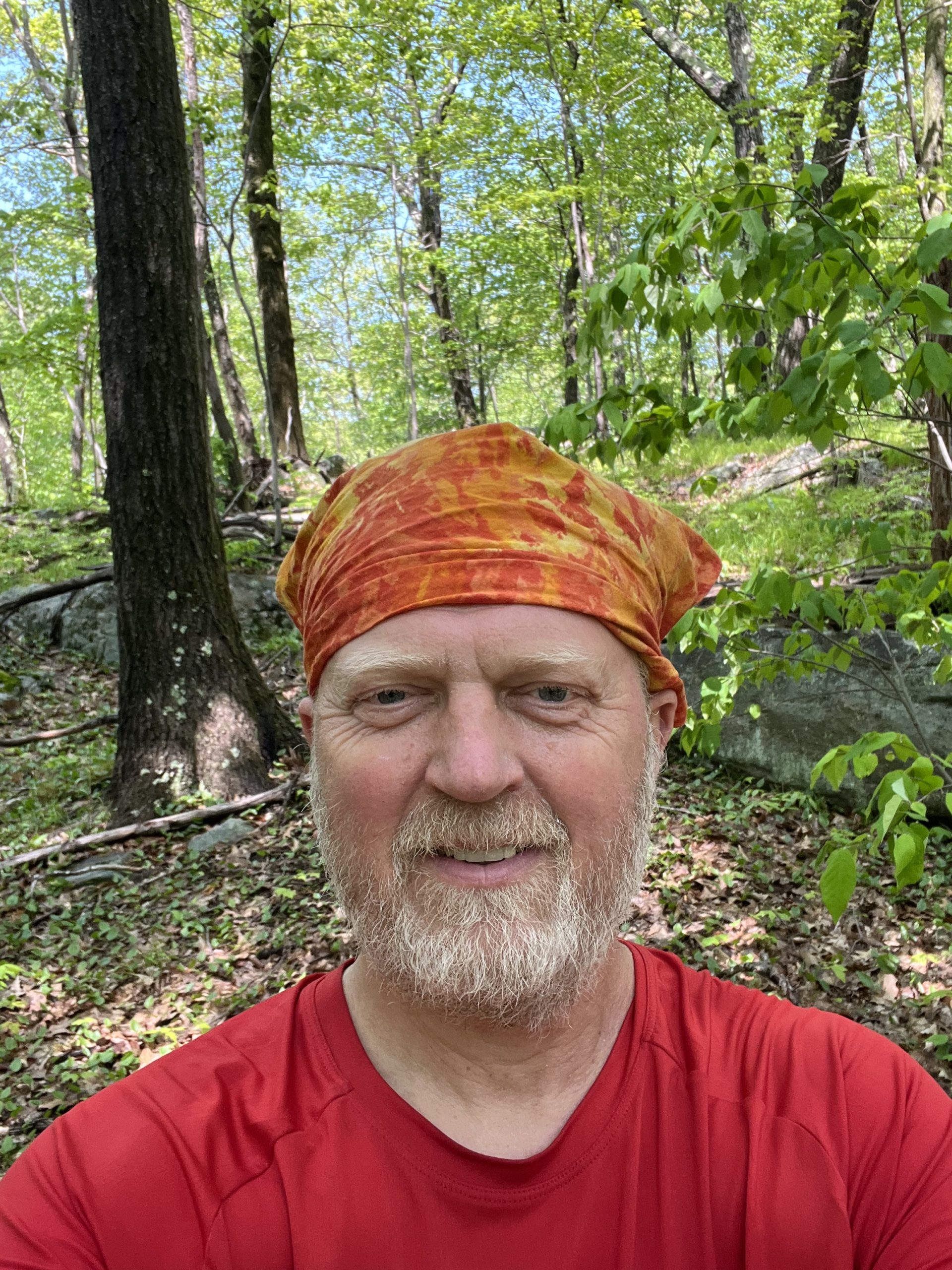
I’ve noted that generally during this first month of my hike that the weather has been very hiker-friendly. Temperatures have generally been in the 60’s or 70’s, and if rain has fallen it has mostly occurred at night. All of that would change on Day 31, as the mercury would rise into the 90’s for two straight days. So I needed to take emergency measures, putting my “blaze” bandana fully over my head. I’d drench it periodically from the cold mountain streams – it seemed to work great!
And that, of course led my non-stop music playing brain to launch into Kansas’s “Fight Fire with Fire”. Even I’ll admit that’s a mediocre song, but I hear it enough when I decide to spin Kansas’s greatest hits album. I never thought that John Elefante was going to be able to lead that band — former vocalist Steve Walsh was just too good. It’s too bad he couldn’t work out those “artistic differences” with Kerry Livgren — they could have made a lot more great music. And I know many of you may know the band for their great singles “Dust in the Wind” and “Carry On My Wayward Son” (and deservedly so), but I love Kansas’s prog rock side. If you haven’t heard “Closet Chronicles” or “The Wall” give those great tunes a listen.
I’d manage 17 miles on that first hot day, and the Day 31 MMM was finding a beautiful rushing river in the shade for my lunch spot. As an added bonus, I ran into Lampshade for the first time in about 10 days on the trail. It was great to catch up!
An update on Shingo
Many of you will recall I spent four days traveling with a Japanese hiker named Shingo. Several hikers gave me an update that he was found disoriented several days ago, wearing his flip-flops, with his hiking gear miles away at another shelter. I’ve since learned that he was taken to get care at a hostel by some thoughtful hikers, and the Japanese consulate was contacted so his family could be reached. I share this cautionary tale because it is so important to take care of your body out here with proper liquid and diet.
Get better Shingo, I hope to see you back on the trail again soon!


This website contains affiliate links, which means The Trek may receive a percentage of any product or service you purchase using the links in the articles or advertisements. The buyer pays the same price as they would otherwise, and your purchase helps to support The Trek's ongoing goal to serve you quality backpacking advice and information. Thanks for your support!
To learn more, please visit the About This Site page.

Comments 5
Great playlist
052622 really enjoyed your blog about going through Harriman Park. That’s my local area we ran into Cosmo on 518 at Bear mountain.
I’m sorry you weren’t in Harriman when it got hot because there’s some beautiful lakes there. The New York New Jersey trail conference does an excellent job of marking the trails. Fred is an old hiker who does trail magic right on route 17 near the elk pen. He does a great job. Wishing you well on the rest of your journey
High Road! Enjoy your time home. Thanks for the good company last night. I said it then and I’ll say it again, that was some great timing with my arrival at N. Wilcox. The new shelter at S. Wilcox was pristine, and I had it to myself. I’m home now, and already itching to get back out there.
Boom — I’m enjoying it immensely, just as I enjoyed our conversation at N. Wilcox Shelter during the rainstorm. Best of luck in your future hiking endeavors!
High Road
I certainly know what you mean about trail design! I always found the WMNF trails in New Hampshire to be especially good. That, of course, is getting ahead of the story, but i really like your “conversation” about the premier trail designers.