 ">
">
Day 54: Adjusting to a Middle State
Things have felt different since the third-way point in Daleville. The mountains are lower and rounder, the trees are greener, the trail feels less buried in the mountain fastnesses of the South. Almost every day is warm, and the bubble of northbound thru-hikers has all but disappeared. The natural world around me is newly familiar, a homecoming to the northern Blue Ridge I knew growing up in Maryland. Between all that and the fact that I’ve changed out gear, I have the sense of starting a whole new hike.
Southwest Virginia is different from the rest of the state. Sure, Virginia is part of the South, but there’s a reason it’s often included in the Mid-Atlantic. In its northern half and throughout its larger cities, the sharper cultural lines have blurred, and this is true all the way down to Roanoke. Even before, the people east of the mountains were never the same as the hill people, deep in those ‘mountain fastnesses’. The fierce, ramshackle self-reliance that you feel west of the Divide gives way in the east to a more mainstream kind of culture.

As the season’s changing, flowers like this orchis are popping up all over the place.
I may not have crossed a state line, but for the first time I find myself truly in a middle state. Midway between the Deep South and New England, Springer and Katahdin; midway between winter and summer, cold and heat. By the time I leave the ‘Middle States’, winding my way into Connecticut, I will have completed another third of the trail. It will be the dog days of summer, and a distinctive regional accent will start creeping back into the locals’ speech. Everyone likes to talk about the halfway point, but I think the trail is best thought of in thirds.
1. An oasis on the interstate
Daleville really surprised me. I expected it to be a little whistle stop on the side of the road, with a truck stop and a few beat-up motels. Instead I found the Super 8 to be a tidy, comfortable, clean hotel, so hiker-friendly it felt almost like a hostel. The Mexican restaurant next door had excellent food, and a short walk down the road led to a strip mall with a coffee shop, grocery store, and outfitter. What more could you need?

My ‘cheap motel room’ in Daleville.
I spent my zero day lounging around, enjoying my private room, and walking back and forth to the shopping center. I switched out my winter quilt for a 40-degree one, and bought a new pair of shoes since my soles had worn out (more on both of those later). Since my old one had sprung a leak, I also bought a new CNOC bag, and I replaced my heavier cargo shorts with lightweight running shorts. At the Kroger, I shopped for fancy snacks and cheeses to my heart’s content, coming out with three avocados and a hunk of gruyere for the trail.
The next morning I had breakfast at the hotel before heading out to cross I-81 for the second time. The first crossing is 200 miles back, and the last two are way up in Pennsylvania. This second one is special, though — it’s the exact one-third point of the trail. Mile 731.4, a third of the way from Springer to Katahdin. And then I followed a gentle gravel path up into the Blue Ridge.

One third of the trail down, two thirds left to go!!!
2. New Shoes
The first few miles up felt great, but on the downhill I noticed that something felt off. My toes kept bumping into the front of my new shoes. They were the same model I’d been wearing before, only a half size smaller — 11 instead of 11.5. I thought this would help improve the fit, since I was suffering from pain in the balls of my feet, but now I had created a new problem! My mind was filled all day with thoughts of blackened, rotting toenails, and eventually I caved and called the outfitter. Was there anything they could do?
It turns out there was. To my surprise, the owner offered to meet me on the trail the following day, on his way back home to Roanoke from Lynchburg. He didn’t have the same shoes in 11.5, but he’d bring a few options for me to try on. And sure enough, there he was at 5pm at an overlook on the Blue Ridge Parkway, the trunk of his car packed with shoeboxes.

Before I changed my shoes, I hit the 800 mile mark!
I can’t stress enough how great this outfitter was, or how good he was at communicating with his customers about issues with their gear. It’s also absolutely amazing that he was willing to take time out of his Sunday to meet me on the Parkway to try on shoes. So if you’re ever in Daleville or Lynchburg (where they also have a store), check out Outdoor Trails. They’re great.
I tried on a few pairs of trail runners and boots — Merrells, Hokas, Topos — and took them a few hundred feet down the trail on a rocky slope. None of them felt quite right, and then I found my Goldilocks shoe. It had a rock solid build, with a grippy sole, firm arch support, yet none of the clunkiness of a boot. I could break into a run if I wanted to, or clamber up a rock face off trail. And so I am now the proud owner of a pair of La Sportiva trail runners, a brand I’d never even heard of before last week.
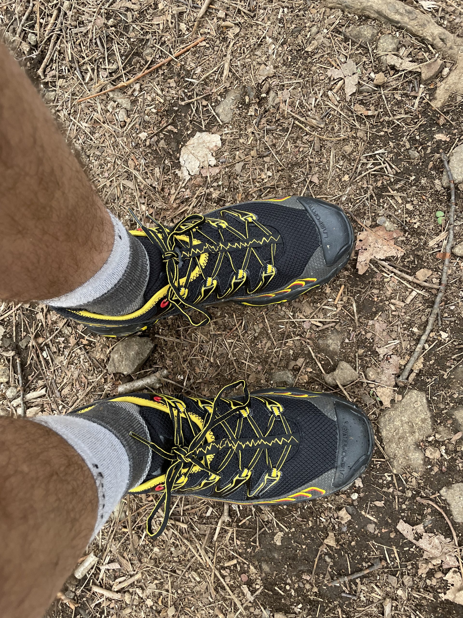
My sporty new pair of La Sportivas.
John (that’s the owner’s name) also gave me a pack shakedown before he left, teaching me a better way to adjust my straps and suggesting that I pile my things into a tall cylinder by packing them in the top of my food bag. It was definitely good advice, and I’ve adjusted my routine a little moving forward. My clothes now go under my food instead of on top, and I have fewer little loose objects to fish out when I empty my pack. But habits change hard, and all these changes have taken a lot of getting used to. It strengthens that feeling I already had that I’m starting a brand new hike.
3. Bridge over the James River
This section of the trail, when it’s not following the Blue Ridge, runs steeply up and down between ridgetops and deep valleys. At Jennings Creek, a tributary of the James, the trail dips below 1000 feet elevation for the first time. And on my third day out from Daleville, I reached the lowest point yet, where the trail crosses the James River at 654 feet above sea level. An improbably long foot bridge (appropriately dedicated to William T. Foot) spans the river, and the south end of the bridge is a popular swimming spot. Despite the many signs prohibiting jumping from the bridge, at least a dozen young people were doing just that when I got there.

Those girls are far braver than I! I jumped in from one of the lower steps of the piling.
It was a hot afternoon and I badly wanted to swim, but I crossed the river and hurried over to the parking lot. I’d had a box sent to the hostel in Glasgow, Virginia, where I’d originally planned to spend the night. But the town was small and two miles off trail, and the guy at the hostel had places to be. So we agreed that he’d just bring the box to me at the trailhead on his way out, and I’d grab my stuff there and move on.
I thought he’d be there at 2:15, but something held him up. I’m a bit high-strung — it’s part of why I chose a squirrel-themed trail name — and I started to panic as I waited in the lot, tired, hungry, and hot, with no cell service. By the time he arrived at 2:45, I was really freaking out, though relieved to finally have my stuff. We had a rushed exchange, and he sped off down the road, probably shaking his head at ‘kids these days’.

Hanging out by the James River
After that, I crossed back over the river and took a deep breath. I made myself lunch and dove into the water while it cooked, swimming back and forth in the deep current of the river. There’s an earthy, watery smell to big rivers that I love, and it felt amazing to plunge into the cool water on this hot sunny day. Meanwhile the kids were hanging out on the bridge, daring each other to jump off, playing music and having a good time. It felt like a little piece of summer vacation that I’d happily stumbled across along my way.
4. Priests and Spies
All good things come to an end, and by late afternoon I was huffing and puffing up another steep climb. That night I stayed on top of Bluff Mountain, a 3300-foot knob with expansive views. I forgot to put my trash in my bear bag, and some creature tore it up in the night, confirming that it really does pay off to hang your stuff in a tree. I’d heard a faint growling in the bushes where my trash was being picked over, but I still have no idea if it was a bear. Personally, I think it was a raccoon.
The trail went down to the tiny Pedlar River the next day, and stayed down in its valley for a while. I loved the leafy smell of the moist forest air, the beech trees spreading out over the brooks and the multicolored flowers pushing up along the path. One section of trail was fringed with irises, another with geraniums. The upper slopes looked like fields of trillium. Everything was a bright, almost fluorescent, spring green.

The springtime woods down by Brown Mountain Creek.
And yet the cold at night was a little too much for my new quilt. The lower ten degrees of a sleeping bag’s rating are less than comfortable, and I started to shiver in my wool base layers around fifty degrees. I anxiously looked at the forecast, seeing lows in the mid 40s for next week. Maybe I’d been hasty in declaring the cold season over.
The next day, I was back on the ridgetop and headed to the last 4,000-foot mountain till Vermont. It’s called The Priest, though nobody quite knows why. It has a distinctive inclined profile rising up from the surrounding peaks, reminding me in a way of Standing Indian. I crossed a roller coaster of smaller knobs on my way up, the last of which, Spy Rock, has a bare rock summit with commanding views of the surrounding countryside. Someone told me it was used by literal spies on both sides of the Civil War, as the best reconnaissance point for miles around.
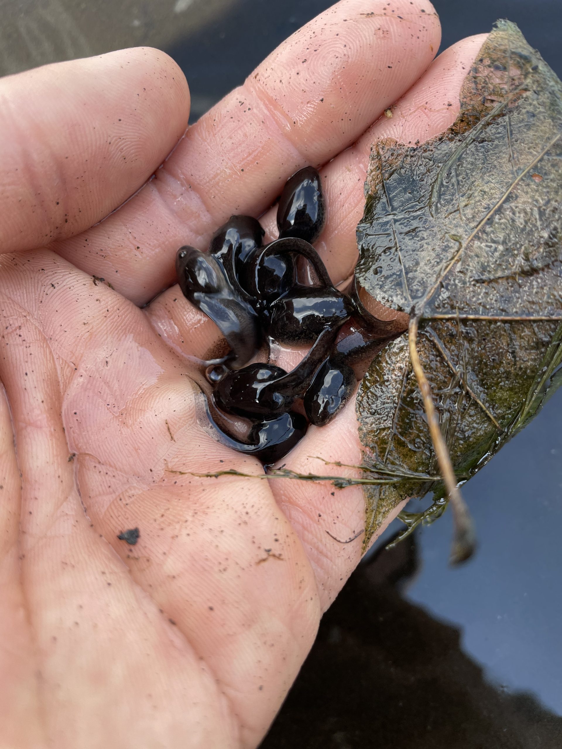
A handful of tadpoles on Spy Rock.
After the rain, there were pools of water on the summit of Spy Rock, and they were filled to the brim with wriggling tadpoles. I could scoop my hand in and come up holding four or five. Crowded together and trapped on this rocky outcrop, how many of these can hope to reach adulthood? And yet, if some mother frog made it up here from the water, maybe they too can grow legs and hop down to a stream.
The Priest had great views on the summit, and a standing rock formation that felt like a guardian stone. I was anxious, though, about the deep gorge that followed, the 3000-foot drop to the Tye river and 3000-foot climb on the other side. So I didn’t, perhaps, take the time I should have on the peak, exploring the high point and admiring the views. Instead, I wound my way downhill and took a long break at the little river, preparing myself for the evening climb.

Looking back at The Priest from across the valley.
When it came, I took it slow and steady, and it wasn’t so bad. By nightfall I’d reached the top of Three Ridges and set up camp, while deer crashed all around me in the dark.
5. Welcome to Waynesboro
Yesterday was a good day for walking. The air was humid but cool, with the sun peeking out from behind thin clouds. The trail tended mostly downhill, finding its way down the ridge to Rockfish Gap.
I’d decided I needed to do something about the quilt. It was wonderfully lightweight, but if I didn’t sleep well at 49 degrees, how would I feel at 41? I called my partner, Andrea (check out her artwork!), and asked her if she could send my winter quilt to Waynesboro by next-day mail. After talking it over for a while, she decided to drive down and meet me there instead! I’d walked so far along the trail that I was only a three-hour drive from home.
And I could tell. By mid-afternoon, the overlooks were showing me views of the Shenandoah Valley, Massanutten Mountain rising up in the distance like the keel of a great ship. I started meeting more section hikers from Maryland than I could put down to random chance. I realized with some surprise that I’m less than 200 miles from the town where I grew up. All that trekking through the wildernesses of the South has, improbably, brought me home.

Admiring the view north from Humpback Rocks.
I waited for Andrea to pick me up at the trailhead, sitting at a picnic table next to a burned-out motel while swallows careened above in the darkening sky. We drove the four miles into Waynesboro and checked in at our AirBNB, which, by pure coincidence, has the same management as the hiker hostel. There was a Salvadoran restaurant next door — for those who don’t know, that’s a very DC-area thing — where we had a late dinner of platanos and pupusas before they closed.
I’m somewhere in the middle of my journey, headed home.

Andrea painting this morning, in the Waynesboro coffee shop where I was writing this post!

This website contains affiliate links, which means The Trek may receive a percentage of any product or service you purchase using the links in the articles or advertisements. The buyer pays the same price as they would otherwise, and your purchase helps to support The Trek's ongoing goal to serve you quality backpacking advice and information. Thanks for your support!
To learn more, please visit the About This Site page.

Comments 1
I love your colorful, descriptive, pictorial writing!
There is a market for this type of writing!
Aaron, thank you for your beautiful pictures and sharing your AT journey.
Love, Catherine Marcoux