 ">
">
Hiking in Baxter State Park
Most AT guidebooks have a decent description of Baxter State Park’s Regulations and accommodations. But as my trail family got closer to the park and the end of our thru hike, we were a bit confused with some of the rules. In an effort to help you end your trip with the least amount of stress possible, I put together a quick play-by-play of the options you have for your last 15 miles on trail :
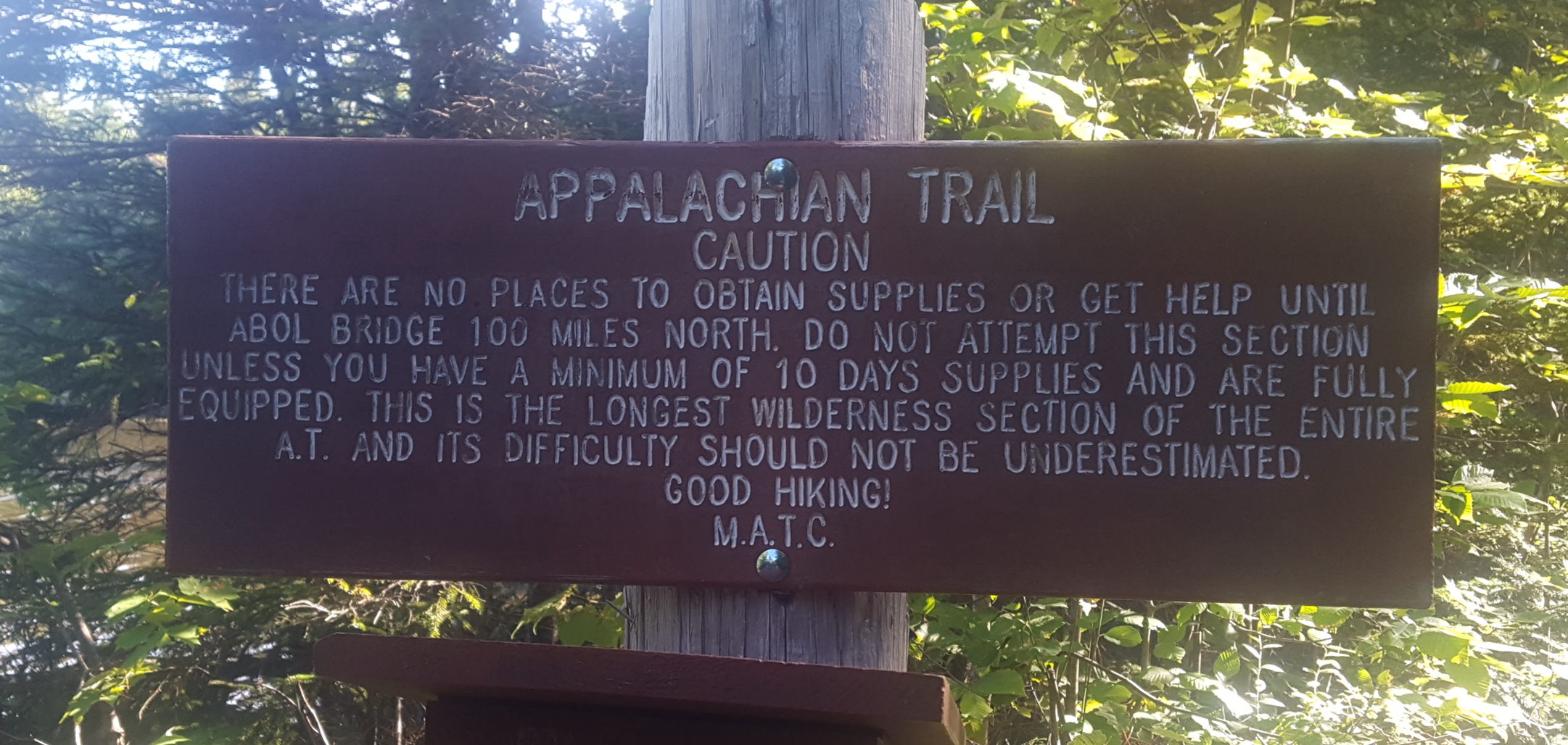
You just exited the 100 mile wilderness and there are only 15 miles separating you from Mount Katahdin! Starving and tired, you only have to walk 0.5 more miles until you hit Abol Bridge Campground and Store. Considering you only have 1 or 2 days left on trail, the resupply isn’t too bad. The camp store and restaurant are both overpriced (They make it known that the property is powered by a diesel generator, which is reflected in their prices). They also have beer, wine, and a free buffet breakfast if you pay to stay at one of their campsites.
0.5 miles north of Abol Bridge Campground is Baxter State Park’s boundary. There are a few scattered stealth spots in the last 0.2 miles before the boundary. There is also a large group stealth spot in the woods 0.3 miles south of Abol Bridge Campsite.
You are not allowed to stealth camp in Baxter State Park so you have four main options for summiting Katahdin: hike the 15 miles in from Abol Bridge, hike 10 miles in and stay at the base of the mountain at the Birches Campsite, hike 10 miles into Baxter to the parking lot and hitchhike into Millinocket for the night, or reserve a lean-to at Katahdin Streams Campsite.
Each of these options have pros and cons:
Hiking from Abol Bridge to Katahdin’s Summit
Pros:
- you don’t draw out the anticipation any longer! Get up early, smash out the 15 miles, and bask in the glory of Katahdin!
- If you get up early enough and start your ascend before 6 you will beat the day hikers up the mountain (gates open at 6).
Cons:
- 15 miles up Katahdin + 5 miles down Katahdin = a very hard 20 mile day. Although 10 of those miles are pretty much a cake walk leading up to the mountain, it should not be overstated that the climbs up and down the mountain are hard.
- The first 10 miles of the hike are also crazy scenic. Not to mention how insane the ascend and view atop Mt. Katahdin are. In my opinion doing a 20 that day doesn’t allow you to take in just how beautiful the end of the trail is.

The signup for The Birches campsite is only 0.5 miles north of Abol Bridge Campground/restaurant
Staying at the Birches
Pros:
- you get an easy 10 mile day to take in the beauty of Baxter. And it really is beautiful.
- Gates open at 6am for the public, if you get up before that you can beat the traffic and enjoy the summit with less foot traffic.
- It makes for a manageable summit day: 5 mile ascend and 5 mile descend.
Cons:
- there are only 12 spots available at the birches. The signup is located on the AT 0.5 miles north of Abol Bridge (the entrance to Baxter), so you will know if it is full before you hike the 10 miles in.
- there is a $10 fee per hiker (pay at the ranger station in the park)
Hitchhiking into Millinocket for the night
Pros:
- You shorten your summit day to only 10 miles: summitting and getting back to camp.
- You get a full meal from town to prep you for your ascend.
- You get to meet up with everyone that summitted that day and say goodbye one last time before they leave for the real world.
- Hitching to town is easy in the afternoon and you can arrange a shuttle back into Baxter with the hostel.
Cons:
- getting a car ride back into Baxter means you will be hiking up with the masses. Cars are usually lined up for the 6am entrance because if they don’t make it in by 7 they lose their parking reservation.
Reserve a lean-to at either Katahdin Stream Campground or Abol Campground
**(this is confusing but Abol Bridge Campground and Abol Campground are two separate entities. Abol Campground is located 2 miles away from the Birches, Whereas Abol Bridge Campground is located 10 miles south of the birches)**
Pros:
- you can reserve the lean-to as early as you want. You don’t need to worry about being the first to the sign up sheet that day like at the birches.
- It’s cheaper. Most of the lean-tos cost $30 and can hold 4 campers.
- Your summit day is only 5 miles up, 5 miles down.
Cons:
- your best chance at snagging a lean-to requires you to reserve early which is hard for thru hikers who only know how to plan 3 days into the future.
Knowing these options, there are a few other points to take into consideration:
- There is an ATC visitor center in Monson where you can preregister for your summit day. At the moment, the registration doesn’t actually do much for you. It does help the Park Rangers in Baxter get an idea of bubbles that are heading towards them, and gives them time to to get extra spots ready if they think birches will fill up fast. Extra spots are not guaranteed.
- The Park Rangers in Baxter are kickass. They understand the number of thru hikers coming into Baxter outnumbers the amount of spots available for them. They do everything in their power to accommodate everyone. But it is not assured. With only 12 firm spots available, there is a chance the rest of the campgrounds are filled and you will be forced to either hitch into Millinocket or summit that day.
- The ranger station has slack packs available for you. You aren’t forced to slack pack up the mountain (I chose to keep my regular pack weight) but some of the climbing gets a little gnarly and slacking does help alleviate some of the difficulty.
- There is no cell reception at the base of Katahdin! Verizon has decent reception in good weather at the summit. None of my friends with AT&T had service.
- There are a lot of people that visit Baxter every day. Gates open at 6 and if they don’t get in by 7, they lose their parking permit. So that ensures that if you don’t get up and hiking by 6 you will either be run over by herds of day hikers or stuck in a traffic jam halfway up the mountain.
- There are only a certain amount of parking permits available for the park every day. If you have someone meeting you to hike make sure they make a reservation for their day parking permit and get in by 7 so they don’t lose it. There are different parking lots also,
- Be ready for any kind of weather. The day before we summitted, the mountain looked beautiful. But we learned there were 50 mph wind gusts and crazy fog.
- Unless there is a hazardous weather incident, they do not turn hikers away from climbing Baxter. If you hear someone got turned away in Baxter, it is referring to camping at Birches, not hiking up the mountain.
- Hitchhiking out of Baxter is not hard. The groups usually leave in waves, so there are down times in the parking lots with less vehicles, but most people leaving the park are heading past Millinocket. Millinocket is about 25 miles away from Katahdin, so don’t plan on walking. And as mentioned before, there is no cell reception in camp, so don’t rely on calling a shuttle.
- Don’t be a dick. The mountain is for everyone: whether you have been on the trail for 6 months or 6 hours. Be courteous to others. Don’t stay on the phone for long at the summit if its just to shoot shit with your friends about your accomplishment. Don’t give day hikers attitude if they ask you to take a picture of them. We don’t need to give the park any more ammunition about how rude we are.
- I mentioned before that getting there early gives you the chance to enjoy the end of the journey without day hikers around. I summitted at 4:55AM with a friend and stayed at the summit until about 9 waiting for the rest of my group to get there. We made coffee, had breakfast, watched the sunrise, took our summit pictures and even dropped our packs under a rock and took a victory lap over Knife’s Edge and back…and only had 1 group pass by that wasn’t thru hikers!
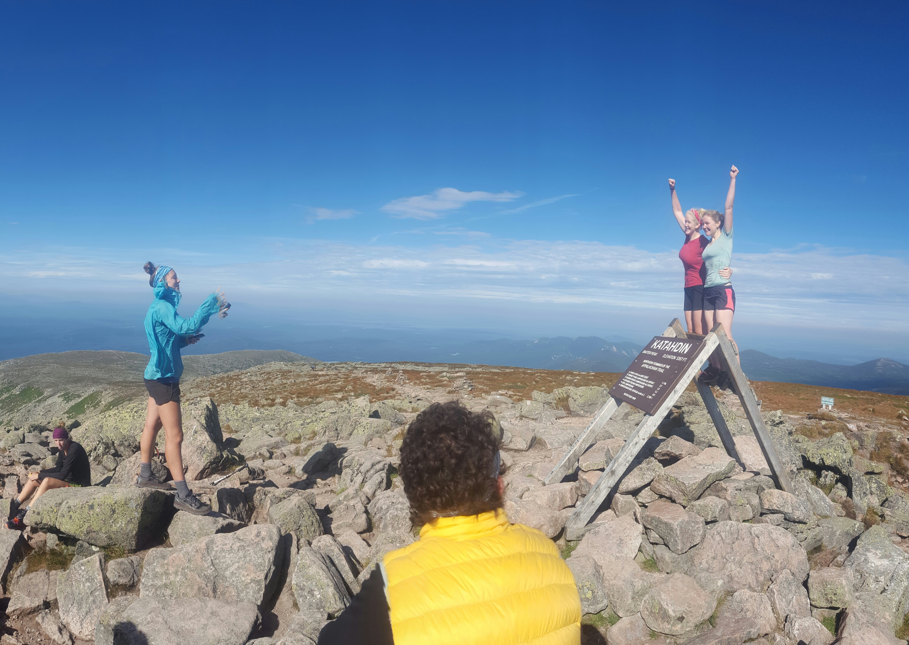
Its more fun taking pictures when theres no crowd
Finally: The Permit System
Baxter state Park has issued a well written statement on the new permit system (implemented in 2016). For the time being, you should not be worried about this disrupting your hike. The easiest way to acquire a permit card is to go to the ranger station (the closest one is right off the AT in Katahdin Stream Campground) and see if a ranger is present. If you can’t find a ranger and are staying at The Birches, he’ll visit the campsite eventually. As mentioned before, the Rangers are kickass. Here is a link to Baxter’s explanation of the permit system:
https://www.baxterstateparkauthority.com/pdf/hiking/ATHikerRegistrationCardAnnounce_Final.pdf

I hope that this info helps make your final days on trail as easy as as possible. The trail provides, and although the regulations set in place are a little sticky, things will work out.


This website contains affiliate links, which means The Trek may receive a percentage of any product or service you purchase using the links in the articles or advertisements. The buyer pays the same price as they would otherwise, and your purchase helps to support The Trek's ongoing goal to serve you quality backpacking advice and information. Thanks for your support!
To learn more, please visit the About This Site page.

Comments 5
Congrats on your strong finish. We are very proud of you.
In a recent Trail Journal post the author stated the folks at the visitor center in Monson had little knowledge of all of this or of hiking. That’s a shame because I think the purpose of the visitor center was to help educate hikers of the rules and process. Hopefully this will help!
1.1 miles from Katahdin Stream campground at the intersection with the Owl Trail and before Katahdin Falls I picked up a signal using a Tracfone (Verizon) and called home. You might call that the base of the mountain.
Stealth site? What’s a stealth site? Stealth camping is when you are far from the trail in a location that cannot be seen. New hikers and there running shoes I tell ya.
Don’t even get me started on how the like to speed hike. Amirite? Gosh darn it things were better back in the day