 ">
">
How to Train With No Mountains: An Austinite’s Guide
So, I’ve declared that I will be hiking the Appalachian Trail in 2016. My friends know, my family knows, my job knows, the world knows through this blog, so now all I have to do is prepare myself. As a full-time employee of a great company, I can’t very well take two weeks off to go on a long shakedown hike. That’s okay, right? I’ll just go on many day hikes and a few weekend hikes. There’s only one small problem. I live in Austin, Texas.
The only mountain that exists in Austin is Mt. Bonnell. It has about 120 steps to reach the top, which make up the bulk of its .3 total trail miles. So. How do I train for hiking the Appalachian mountains when I have no mountains to hike? Luckily Austin (and the surrounding area) has some amazing hikes available. You won’t gain much in the way of elevation, but you’ll see some beautiful natural sights (and sites), and if you combine your hikes with some gradual pack weight and a few hours on the incline treadmill or stair-stepper a few times a week, you’ll be well on your way. Below are some of my favorite hikes in and around Austin.
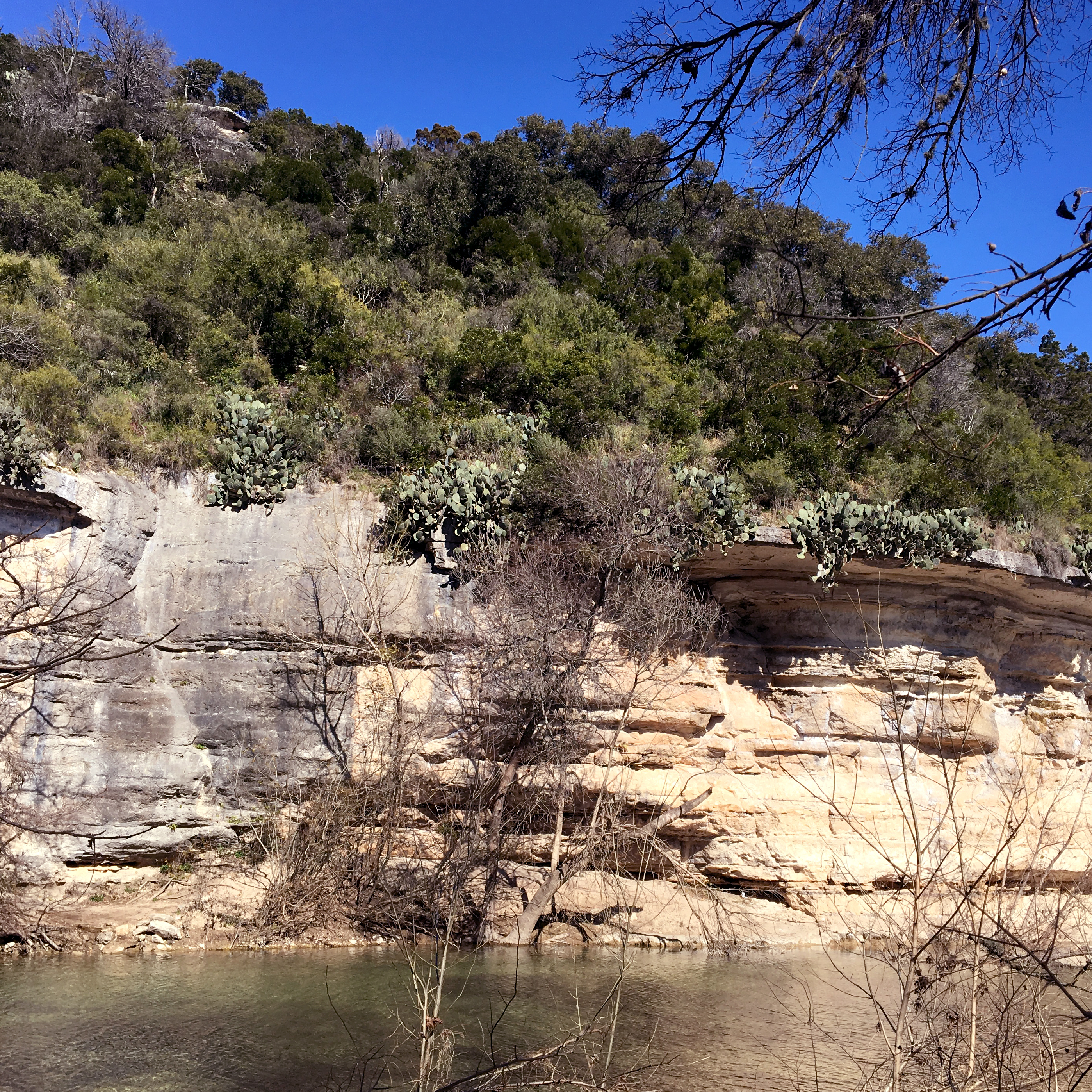
Cliffside cacti on the Barton Creek Greenbelt.
Barton Creek Greenbelt/Violet Crown Trail
Plan Your Visit || Day Hike || Located in Austin: 10 minutes from downtown
The Violet Crown Trail has been my lifeblood in terms of preparation. In its current state, it’s just under 12 miles round-trip. It’s a great half-day hike, running along Barton Creek for most of its length. There are a few water crossings if you choose to follow the exact path of the trail, but most of them can be avoided if you choose, as there are trails blazed along both sides of the creek. On your way you’ll see joggers, hikers, mountain bikers (and one mountain unicyclist!!), and meet many new canine friends. One of the best things about the Greenbelt is that, as soon as you’re in it, you no longer feel like you’re in the middle of a city. You can’t even see the Austin “skyline” from the majority (if not all) of the trail.
Favorite Entrances: The Greenbelt and Violet Crown Trail have many entrances. When I hike the whole length, I usually start at Zilker Park (more parking) and hike to the 290 entrance. My favorite entrance, though, is the Gus Fruh entrance. If you don’t follow the VCT and cross the river, there’s a great hike up a side trail to the top of a cliff, which gives you an amazing bird’s-eye view of Barton Creek and the Greenbelt.
Palo Duro Canyon State Park
Plan Your Visit || Long Weekend || Distance from Austin: 7.5 hours, not including stops
Palo Duro Canyon claims to be the second-largest canyon in the United States, after the Grand Canyon. It resides in the Texas Panhandle, and is virtually invisible in the flat landscape until you’re right on top of it. It features beautiful rock formations with amazing colors from yellow to red to purple. There are many different ways to enjoy the Canyon. It can be explored by foot, mountain bike, horse, or car. We stayed at the Fortress Cliff Camp area, which had good access to the majority of the trails we wanted to do. There are also Backpacking sites available if you wish to be a little further from civilization. We broke the drive into 2 days on the way to Palo Duro, and stayed at Abilene State Park on the way.
Favorite Trails: Lighthouse Trail; Givens, Spicer, and Lowry Trail; Rock Garden Trail
The Lighthouse Trail is a must-do for anyone visiting Palo Duro, it’s an easy, flat trail that takes you to the rock formation known as the “Lighthouse,” which is the most recognizable formation in the park, and even makes it into the logo for the park itself. The Givens, Spicer, and Lowry Trail is a long, flat, winding trail that takes you through some of the most breathtaking high-desert scenery in the park. Connect it with the Little Fox Canyon trail and the Paseo Del Rio Trail to extend your hike. The Rock Garden Trail is a lesser-hiked gem of a trail that ascends the canyon wall and which, along its way and at the top, offers beautiful views of the canyon itself. Continue hiking the Fortress Cliff Trail along the rim to extend your hike.

A view of Enchanted Rock.
Enchanted Rock State Natural Area
Plan Your Visit || Day Hike || Distance from Austin: 1.5 hours, not including stops
Enchanted Rock is a super-neat natural formation. It’s a completely bald pink granite dome that offers a strenuous hike to the top, and a flat, easy hike circling its base. There are even caves and canyons to explore. Overnight camping is permitted on sites and with a reservation, but the park closes at 10pm, so even though the sky is dark enough to see a beautiful expanse of stars, don’t get caught inside the locked gates! Be sure to visit Pieous Pizza or Jester King Brewery on your way to or from Enchanted Rock. both are out-of-the-way gems.
Big Bend National Park
Plan Your Visit || Long Weekend || Distance from Austin: 8 hours, not including stops
Admittedly, I have not been to Big Bend. It’s one of my biggest regrets of my time in Austin that I never seemed to have the time to visit. However, it still deserves a place on this list, so I’ve enlisted the help of friends who have visited. While I’m typing this blog post, we’re having a conversation about Big Bend, and this is the best quote from their five-star review: “I have to say at this point, Big Bend is one of my top favorite national parks I’ve ever been to.” If you have the time, stop in Marfa on your drive in. The quirky little town is worth a visit. Or, if stars are more your thing, catch a Star party at McDonald Observatory, UT-Austin’s home of Astronomy, star-gazing, and giant telescopes.
Definitely consider carefully the time of year for your trip. By May, the park is already very hot, though the temperature can vary by up to 20 degrees depending on what part of the park you’re in. Overall, there is very little shade, so bring a hat and lots of sunscreen. Also, keep in mind that, being a desert the park does get cold at night. There are many different options for campsites, and all amazing. The Chisos Basin Campground is surrounded by beautiful mountains and cliffs, and has access to some of the best trails.
Favorite Trails: Window Trail, South Rim Trail
Both trails offer stunning views, though the South Rim Trail is significantly longer and more strenuous. The Window Trail is 5.6 miles round-trip, and travels down through the Oak Creek Canyon to the “window” which frames a beautiful desert landscape. The South Rim Trail gains 2,000 feet over its length, and offers stunning views of the canyon. There are a couple of different routes to take that vary in their strenuousness.
Pedernales Falls State Park
Plan Your Visit || Day Hike || Distance from Austin: 1 hour, not including stops
A gem of a park outside of Austin, Pedernales offers great day hikes and some overnight camping as well. The Falls are a must-see. Often they are a series of calm pools tucked between massive slabs of limestone, but if there has been any rain recently, they can turn into a spectacular series of falls. Be alert for flash floods if you decide to swim.
Favorite Trails: 5.5 Mile Loop Trail, Wolf Mountain Trail
The 5.5 Mile Loop Trail is a nice trail with some beautiful views, a water crossing, and a scenic overlook. It’s especially nice because it’s customizable. Want a shorter hike? Take the cut-through. Want a longer hike? Add the Spur Trail. The Wolf Mountain Trail is a well-rounded trail that showcases many of the best parts of the natural area at Pedernales. For a much longer trek (15+ miles), connect the Wolf Mountain Trail and the Juniper Trail.
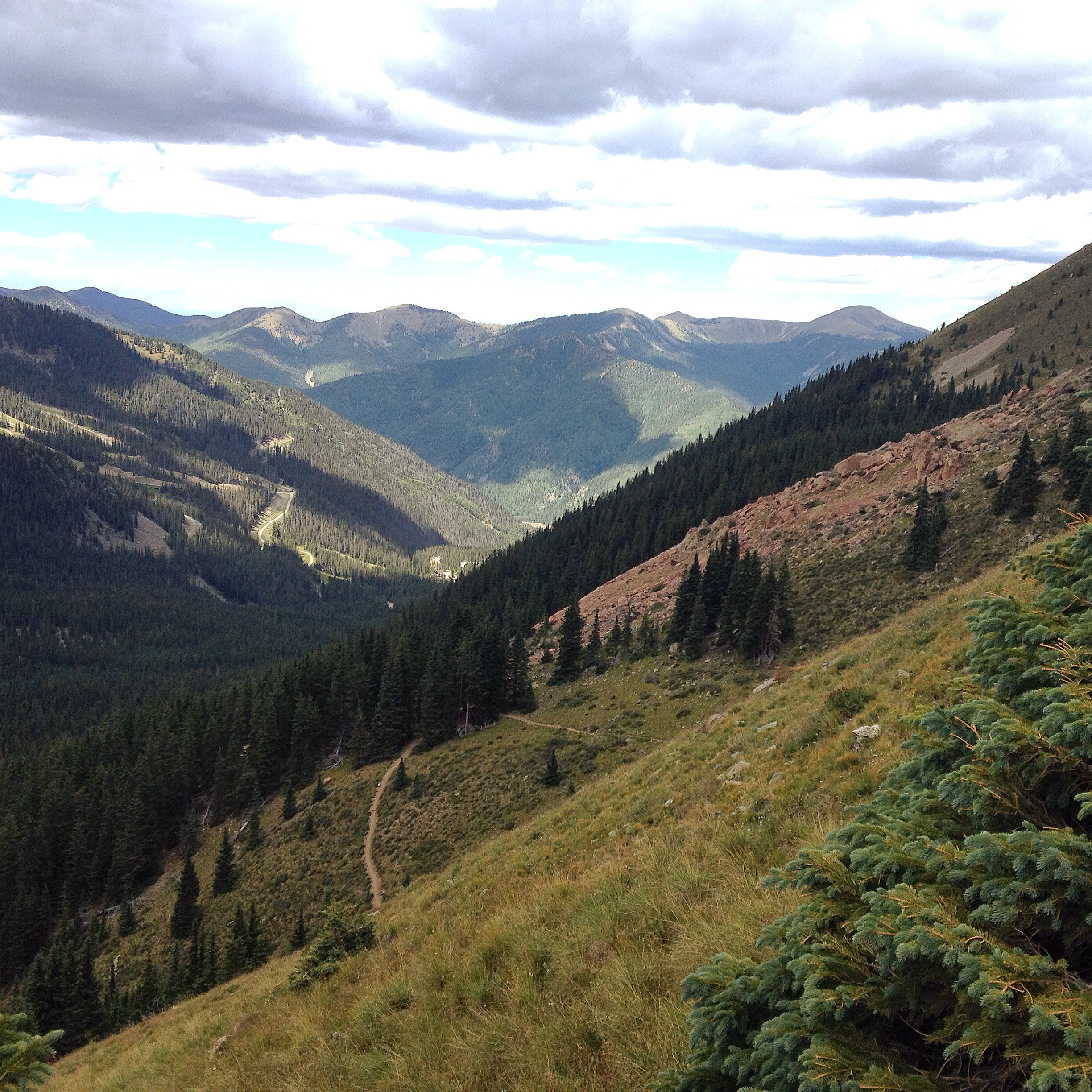
A view from halfway to the Wheeler Peak summit.
Carson National Forest/Wheeler Peak Wilderness (Taos, NM)
Plan Your Visit || Long Weekend || Distance from Austin: 12 hours, not including stops
Finally, mountains! This one is a long drive or a short flight, but is one of my favorite hikes that I’ve done since being in Austin. I went in early September, and the weather was beautiful. In the winter, the area is used for skiing and snow sports, but if you’re into cross-country skiing or snowshoeing, I’m sure the views will still be amazing. We didn’t camp during our stay, but Carson National Forest does offer many options for campgrounds. Be sure to stop in Roswell, NM on your drive. Maybe you’ll see some aliens.
Favorite Trails: Wheeler Peak Summit Trail (#67), Williams Lake Trail (#62)
These two trails run together for a while. Eventually the trailhead for the Summit Trail will be on your left, but it’s worth it to continue the short distance to Williams Lake. The Williams Lake Trail offers a chance to relax by the lake, and a couple of small bluffs to climb to get better views of the surrounding area. The Wheeler Peak Summit Trail offers what it promises, breathtaking views the whole way up, a variety of landscapes, and an amazing hike to the summit. Beware of changing weather in the afternoons on the summit.
Did I miss any of your favorite trails around Austin? Let me know in the comments!

This website contains affiliate links, which means The Trek may receive a percentage of any product or service you purchase using the links in the articles or advertisements. The buyer pays the same price as they would otherwise, and your purchase helps to support The Trek's ongoing goal to serve you quality backpacking advice and information. Thanks for your support!
To learn more, please visit the About This Site page.

Comments 10
If you include Big Bend, you should definitely check out the Guadalupe Mountains. They are a barrier reef back in the day. The western face is a sheer 5,000 foot drop and golden eagles love to hang out there. Since there is no water, you need to carry it all up hill. Spend the night on the western side, I think it is called the bench. Cowboy camp one night and come down the next. You can thank me later.
Thanks for the suggestion, George! When I’m back in Texas after the Appalachian Trail, I’ll definitely check the Guadalupe Mountains out.
Try to go when the golden eagles mating. You just don’t see that every day!
True! Sounds like a crazy but wonderful sight to see.
Another Austinite doing the AT. Cool! I’ve got a buddy (also from Austin) hiking this year as well (BevoHi is his trail name). I hiked the AT in 2013. I used Barton Creek Greenbelt as a training place as well. I’d do about an 8-mile trek 1 or 2 times a week in conjunction with my normal fitness routine (running, lifting, etc). I’d use some Scout hiking trips (Big Bend, Lost Maples – really nice state park -, and Grand Canyon) to get ready for my AT hike. In fact, I did the Grand Canyon the week prior to leaving to GA. 3000′ climbs on the AT didn’t frighten me after climbing out of the Grand Canyon. I’ll leave my actual hiking itinerary in the website below (w/ hiking times & other data; a good reference for planning). I finished my hike in 152 days (just shy of my 59th birthday for reference).
Thanks, Carl! Super useful information. I’ll say hi to your friend if I see him! We can swap Austin stories. I’ve always wanted to hike the Grand Canyon, but never have. Maybe I’ll follow your example and fit it in right before I leave.
Hmmm. Don’t know if the itinerary posted or not. I’ll add it here as well. https://docs.google.com/spreadsheets/d/1Vq3wfR_I1vBnCQkuIrKKB_Kx0xdti_I8Tf37jA3gt1M/edit#gid=0
Thank you. I live in Miami, Florida which Is entirely at sea level with no inclines. I have basically been training the same way that you have, except in the summer I did do some small section hikes on the AT. Hope to see you out there this season.
Wow, I think Miami might be even flatter than Austin! Though, I guess that those of us who are intent on the AT will always find a way to train. Best of luck, and please say hi if you see me out on the trail!