 ">
">
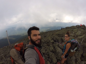
Journal Through the Whites
The Whites are no joke…
I thought I’d depart from the mass-mileage update and do a day by day journal through the White Mountains. Let me start by saying that going into “The Whites,” you hear a lot about them. How hard they are. How slow you’ll go. How unpredictable the weather is. As with most of the trail, you start to assume that people are really playing it up, using the extremes as an example. WRONG! WAY WRONG!! For probably the first time on the trail, the stories have lived up to their hype; let me amend that—the hype has not done justice to reality. To say that The Whites are no joke is itself a joke—the mother of all understatements. Let it be noted, I am writing this update at a point 20 miles shy of the end of the White Mountains section, and admittedly, we are beat down physically, mentally, and emotionally. Read on to find out why, and then you can genuinely cry along with us. The following reflections are those penned at the end of each day, edited very little to preserve the raw and true emotion of the day, except for several foul words that I took out for the sake of our mothers and other sensitive readers.
Through the White Mountains
First up is an overview of the AT through the White Mountains. The trail goes through the White Mountain National Forest for about 100 miles, roughly from Glencliff to Gorham, NH. The Whites are notorious for their steep climbs and descents, rocky terrain, and unpredictable weather. Even though, at this point in the journey, we have made it through twelve states and over 1800 miles, the Whites are known to be the start of the toughest part of the trail. For us NoBo hikers, it has been extremely disorienting to have to break our routine of the 18-25 mile days to which we have become accustomed. As reality has set in, scaling back our daily mileage goals is more a necessity than an option, as the majority of us thru-hikers have found once encountering the Whites. It’s simply not possible to go fast over the rugged terrain. The other complicating factor in the Whites is trying to plan out mileage that jives with the White’s camping regulations. In the Whites, you can’t camp above the tree-line, which would be fine, except that it’s almost impossible to know what above tree-line is until you’re there.
Other trail anomalies exist, among them are the Huts scattered throughout the Whites. Huts are hike-in only bunkhouses that are fully equipped with kitchens and staff that can be reserved for the night– for a hefty price, ranging from $100-$150 a night per person. Huts are not there for thru-hikers and don’t cater to our kind; they are more so there for day and weekend hikers. However, Huts can be very accommodating to thru-hikers if you hit them at the right time. The Huts take a couple of hikers a day on a work-for-stay basis, but that status is not determined until late in the afternoon, between 4-5pm. Some hikers try to plan their days around the hope of being able to avail themselves of the coveted work-for-stay option, but it is anything but guaranteed. Thankfully, even If you aren’t hitting a Hut for a work-for-stay, you can pop in and ask for leftovers. Hut crews have to hike everything in and out, so offering to take a few pounds of food off of their hands is a win-win for all involved. In short, the Whites require a lot of planning flexibility as almost any plan is likely to be derailed.
Day 1: Jeffers Brook Shelter to Eliza Brook Shelter “Mousilake Day”
What just happened? Like, actually what was that? If this is a taste of the Whites, God help me. Today is a tale of two hikes. The first goes like this: we left Jeffers this morning, geared up and ready to ascend into the Whites, with Mt. Mousilake our first victim. Little did we know that we, the victors, would turn victims before day’s end. Although not officially in the White Mountain National Forest, Mt. Mousilake is considered the first big undertaking for thru-hikers and the first climb of the Whites section. I had built up anxiety about it for days, so it was actually a relief to wake up and know that when we went to bed, we’d be over said mountain. We started out slow but steady and I was surprised at how okay I was during the climb. It was steeper and more sustained than anything we’d done in a while, but certainly not unmanageable. Don’t get me wrong. We went slow. Very slow. Nevertheless, we chugged along and before long emerged above the tree-line, following the ridge up to the summit.
Today was a beautiful sunny day. The wind was blowing, but the skies were clear. The summit was great, and we spent about an hour up there, eating and relaxing. We knew we wanted to get to Eliza Brook by the end of the day. Having heard about the steep descent on the back side of Mousilake, we started to make our way down. If I had thought we went slow on the way up, I was in for a rude awakening on the way down. The “trail” was rocky, slippery, and slow. We followed a waterfall down, but there were times where it was impossible to distinguish one from the other: the waterfall and the trail appeared to be one and the same. Every step had to analyzed, every movement confident and purposeful. It was so slow, so very, very slow. In several sections, the trail was only made traversable by rebar and wooden steps attached to rock faces. When we got down, we took a break at the road, seven miles from the shelter. Feeling good, we figured we just had a couple of hours left in our day. Unfortunately, this is where our day took a turn for the worse.
The second part of our story goes like this: Our map pages had gotten soaked hundreds of miles ago, and when we went to tear them away from each other, the very ends of each page were ripped off. Essentially, we couldn’t tell what the trail map said at either the top or bottom of any of the pages. So… today, while we knew there was a climb out of the notch we were at, we had no way of telling how steep it was. Painfully, it was much steeper and much longer than we thought; basically, we crawled. We really started feeling our legs and the effects of the exertion expended during the previous nine miles. Fast forward four, yes, four hours later, and we were limping into camp. To reiterate, we had been told that it would be slow-going through the Whites, but four hours to cover seven miles, with only one climb, seemed insane. So now, at day’s end, we’re at camp, scared out of our minds at what’s to come and rethinking our whole mileage plan for this section. To make matters worse, there is talk of rain and thunderstorms all day tomorrow, and we go up to a ridge above the tree-line, hiking through rockfields, for a good part of the day… . Can’t wait to see how that goes. Trying to stay optimistic.


Day 2: ZERO
Yes, you read that right. Today is a zero day. In a shelter…on the trail…without cell signal or electricity, with nothing to occupy our minds except listening for footsteps amidst the downpours to see if anyone is coming. We awoke and packed up this morning, fully intending to hike. Before setting out, we decided to go into the shelter and make a pot of coffee while waiting to see if it would start raining. Surprise! Rain it did. And it continued to rain. Fast forward three pots of coffee and hours later, and we are still here and not moving.
Thankfully, we factored in some flex time to compensate for inclement weather and for being without laundry facilities—in other words, for days exactly such as this. Obviously, Rico is much more comfortable chilling out than I am. I’ve already swept the shelter twice. I also got caught up on our daily mileage log, which was a couple weeks behind. I reread our daily journal. Now I’m starting to twitch from boredom. Luckily, a SoBo hiker came and he entertained us for a spell. Then another SoBo-er came, having done a 19 mile day in this weather. Total beast mode. I feel like a total pansy not hiking today, but then again, Rico keeps rolling his eyes and telling me to RELAX. So here I am, trying to relax, but incredibly ready to just get the torture of the Whites over with.

Waiting out the rain
Day 3: Eliza Brook Shelter to stealth site on backside of Lafayette, “Happy Anniversary?”
What did I do to deserve this? Seriously. It’s actually hard to write this as I stare at my screen through freshly tearing eyes. I’d like to claim that my eyes are just sweating, but I can’t even muster my morale enough to lie with any conviction. Again, today is a tale of two hikes. The first goes like this: We left the shelter today in good spirits, super energized from our day of doing nothing. The first several miles went well, although not quick because nothing goes quickly out here. It’s amazing how we’ve had to shift our frame of reference. We used to be able to figure on doing 2-2.5 miles an hour for a stretch, usually succeeding in beating our “time.” Today, we had to mentally prepare for 1-1.5 miles an hour, and then we’d look at the time, chagrined to find we were only roughly on pace, if not slightly behind (!!). So, the first part of today didn’t’ go fast, but we chatted through the morning until we got to the first Hut, Lonesome Lake.
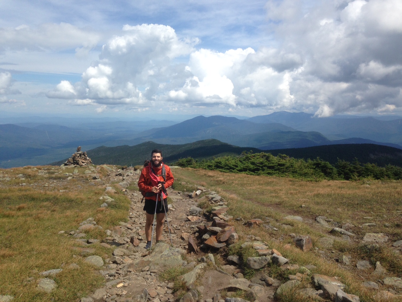
We popped in the Hut and asked if they had any leftovers. We were thrilled to be treated to all we could eat pulled pork, lasagna, and cornbread in exchange for five minutes of doing dishes. Never thought I’d say this… but yay for dishes! Having arrived late morning, work-for-stay wasn’t an option, nor did it sync with our timeline, so eat we did, and on we marched. After the Hut, we descended and then started ascending towards Franconia Ridge, a popular and often talked about section of the Whites. This section of trail is known for its exposed ridgeline and killer views if you hit it on a good day– or should I say, on a good 20 minute stretch. As we got closer to the top, the clouds were low, so we expected to be doomed to another ridgeline with no views. We hadn’t gotten any views as we went along Kinsman this morning– did I mention that? Yep, we did crazy rock climbing to get up to the ridge, only to have it fully engulfed in clouds. Rico and I sarcastically declared, “Oh, wow, this view is gorgeous,” as we looked out into a sea of white. Anyway, we got up onto Franconia Ridge in a whiteout and then the clouds started to break. Rays of sun started filtering through, exposing the expansive and breathtaking 360 degree views. For about 20 minutes, it was incredible. Stunning. The reason you hike the Whites is for views and experiences like this. We could see the trail snake its way on top of the mountains for miles ahead as we cheerily headed north. As if on cue, the clouds rolled back in, and we were once again in whiteout conditions–not a snow whiteout, but one formed by clouds. The wind started whipping—furiously. The clouds were damp, so my glasses kept fogging up and the wind was strong enough to blow my pole back when I lifted it up. To make matters worse, we had made much slower time getting to the ridge in the first place, so we were now racing the clock to get down below the tree-line to find a campsite before dark. Capping off the sordid state of affairs, we were exhausted. Our legs were fatigued, our muscles burning. The rocks took their toll and every step down was like a baseball bat to the knee. Given these less than ideal conditions and after more than a few missteps and slideouts on sheer rock faces as we headed down, I lost it. Tears rolling down my face, I screamed, ” I hate the GD F*ing trail”. All Rico could do was continue hiking and let me have my moment–which turned out to be more like two hours.
The last part of today sucked the life out of me physically and emotionally. It’s exhausting contemplating every step, terrified that one wrong foot placement could send you sliding down a rock embankment. It’s scary to roll your ankle a dozen times a day, praying that that last one isn’t the one where the bone finally gives out from the toll exacted by hundreds of miles of hiking. Topping the list of sad-face factors, who wants to be cold, damp, tired, hungry, and emotionally exhausted on their anniversary? We finally got down under tree cover and found a very damp but suitable stealth site in the trees. Did I mention it was cold, the coldest it has been since North Carolina? My only solace was that Rico let me eat dinner in the tent, tucked into my sleeping bag. Truth be told, Rico had no choice because I had already informed him that all I was going to do when we got to camp was get in my sleeping bag and eat my sour gummies (courtesy of John, Hillary and Mike– thanks!). They were the only things that kept me going today. Thank God for gummies…and my husband—both trail gold!
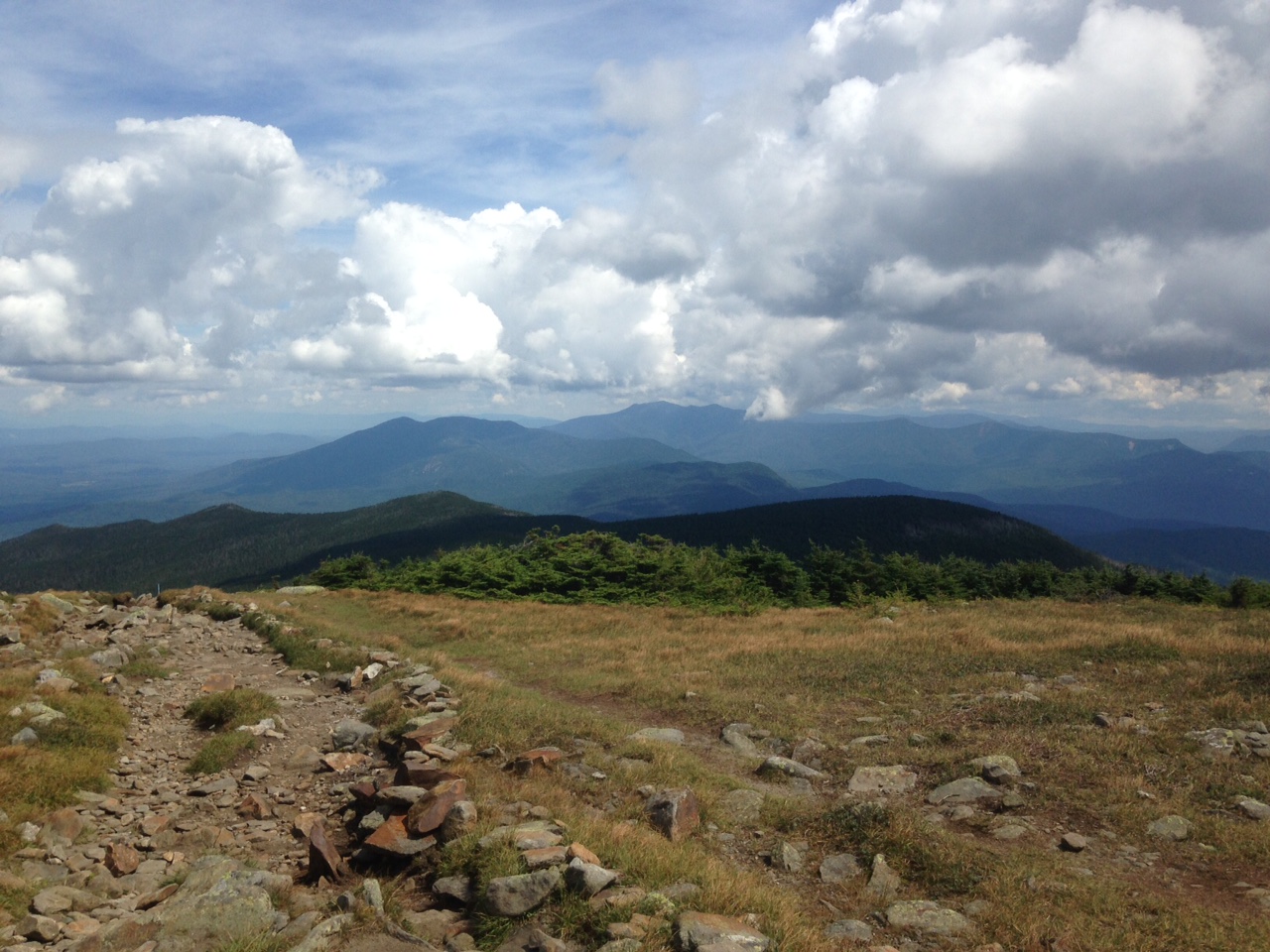


Franconia Ridge
Day 4: Stealth site to other stealth site by Ethan Pond Shelter
Okay, I admit that I’m writing this post in hindsight by a couple of days. Frankly, I nearly forgot that we even did this day. What I remember from today is that I took a nasty spill in mud, in front of amused SoBos no less. Then, on a subsequent fall, I snapped my hiking pole in half. So, now I’m down one pole. That’s literally all I remember about today, except that there were more climbs, we had lunch at a hut, and we hiked some more. Glory days on the AT—or not.
Day 5: stealth site to campsite at Mizpah Shelter
Today was a good day. What? Yes, you read that right. Today was actually a good day. We woke up with the excitement of Christmas morning, knowing that we were getting our resupply of food and a chance at being at a real building for a couple of hours. A jaunt of five miles to the road has never gone quicker– we literally jogged. One very quick hitchhike later and we were at the AMC Highland Center, waiting for the restaurant to open at 11 for lunch and for charging access for our electronic devices. It had been days since we had had service, so it felt like sheer luxury to be in communication with family and friends, though admittedly, there wasn’t much good cheer coming from my end of the phone.
After resting and resupplying, it took us almost a mile of road walking to get a hitch back to the trail, but we left ourselves plenty of time and started back up to Webster Cliffs. The sun was shining and it was HOT, but we actually felt pretty strong as we ascended. The views from Webster Cliffs were awesome, and the subsequent miles were borderline fun. We had to do a good bit of climbing, stowing poles, and using all limbs to hoist ourselves up, but it was a nice change of pace from marching up an endless rockpile. We hit Mizpah Hut in the evening and tried our luck at work-for-stay, which was a no-go, but they told us to try the campsite just two hundred yards away. The Whites also charge for tent sites at sanctioned spots, $8 a person, so we were hoping to work out a deal to do a little bit of work for a waived fee. Luckily, the caretaker accepted our offer and for a two foot tent platform we raked shit—for real– for 30 minutes. To clarify, we raked bark that contributed to the composting privy, but the bark was once covered in shit, so my previous statement stands. We did the job in short order, chatting with the caretaker the whole time, so we didn’t mind the task. Plus, camping that closely to the hut meant we had potable water that evening and the next—oh, life’s luxuries on the trail. Mount Washington is tomorrow. God help me.

You can see how strong the wind is from my sweat rag blowing in the wind.

The “trail”

Shoveling shit….
Day 6: Mizpah Hut campsite to Osgood campsite “Mt. Washington”—officially dubbed our most disappointing accomplishment.
Where is the emergency exit on the trail when I need it? This is the most sullen hiking I’ve ever done in my entire life. To make matters worse, Rico has now jumped aboard the train of despair I have been driving since we entered the Whites. Normally, when I get downtrodden out here, I rely on him to stay upbeat, or at least to not engage with my mood. But now, he’s just as down and sullen as I am, and we are a very sorry sight to behold. Officially accruing more tears cried than smiles cracked in the Whites, we are hurting, and hurting bad. Saddest of all, today wasn’t really that bad until the very end. We started the day strong, and dare I say fast, doing the first five miles from our hut to the Lakes in the Clouds Hut, at the base of Mount Washington, faster than anticipated.
We traversed a good part of the Presidential range that morning, not summiting every mountain, but making our way around them. We were above the tree-line the whole morning, and even though it was rocky, the terrain was manageable. A surprise of leftover pancakes and eggs energized us to get up to Mt. Washington to celebrate our accomplishment. Washington is the second highest peak on the AT (after Clingsman Dome), but I think it’s more exciting because the climb is definitely more challenging than Clingsman. Mt. Washington also boasts the most severe weather in America, once clocking a record wind speed of 234 mph. As if our stress levels weren’t high enough, we passed a warning sign that read: PEOPLE HAVE DIED on the way up. All told, arriving at the top of Mt. Washington should have given us a heightened sense of accomplishment. We marched up the steep 1.2 mile rocks from the Hut to the summit and the whole time I imagined how exciting it would be to finally reach the top.
The trail was crowded, but we received tons of encouragement from several hikers who took one look at us and asked “Oh, are you thru-hikers?” And then we reached the summit… and it was a sight to behold, unfortunately, far from pleasant. In one word, it was horrible. The weather was fine, but cloudy, obscuring the view (not a huge shocker there)—overall, it was a freaking zoo. There is a road that goes right up to the top and we so happened to be there on a Saturday–big mistake on our part. To top it off, there was a bike race up to the summit. So, there we were, used to summiting mountains in the solace of nature, now smack dab in the middle of mountain Disneyland. There was a DJ. There were porta-potties and one million people. As if that weren’t disconcerting enough, THERE WAS A LINE TO TAKE A PICTURE AT THE SUMMIT SIGN.
I could’ve cried. I didn’t, but I wanted to. After standing in lane for approximately five minutes, the whole scene was just too much for us and we said “screw it” and continued on. We know we got there, and we were damn proud. But, we were also hugely disappointed that such a milestone for us was ruined by people who literally walked 500 feet from the parking lot and then posed at the sign like they had walked 1860 miles to get there. Obviously, I’m a little bitter about the whole thing. We made our way down from the summit and kept our eye on Madison Hut with the hopes of getting a work-for-stay, thinking we’d hit it at just the right time, late afternoon. The next several miles dragged and were draining–nothing too steep, up or down, but there were several rock fields. It felt like we were back in Pennsylvania.
This is when Rico started declining. I don’t think we ate enough, and the long trudge around and over the rocks started getting the best of us. Adding to our anxiety, everyone was telling us there were thunderstorms rolling in, probably severe, so we were on edge to get down below the tree-line. We got to Madison Hut around 3 or so and asked about work-for-stay, citing the incoming storms in hopes that that would work in our favor. Unfortunately, those hopes were dashed because they were saving space for hikers who would get there later than us and would probably be in more dire need of a place to stay. This meant we had three more miles to go, up a steep climb to Mt. Madison and then down to a campsite. Truthfully, we had no desire to hike another step. We were done for the day. However, with no other option, we headed out.
The next three miles were by far the worst and slowest miles of the whole trail. While we knew we’d be slow getting up the steep climb to the top of Mt. Madison, we were not prepared for the even slower-going pace required to navigate the backside of the mountains. The rocks were jagged and misshapen, each step requiring extra effort. On top of that, there was no apparent or reasonable trail down. We’d go ten feet to the right, only to go ten feet to the left, in order to merely drop down three feet. Repeat for two miles and two thousand feet and we were understandably toast. We literally looked like we had been sentenced to walk for the rest of our lives. Needless to say, there were more tears—steady and plentiful. We limped into camp, both of us with crazy rubbing-induced blisters on both of our feet, knees shot, and our joy for life significantly diminished, if not lost for the duration. Serious business, guys. We’re hurtin’! ONE MORE FULL DAY. Can we even make it?

The solace of Mount Washington…….. or not.
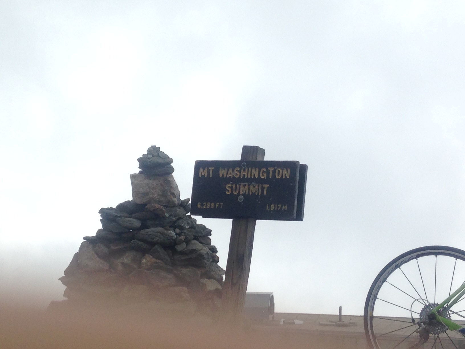
This is our epic Mt. Washington picture…..


Coming down Madison. I am not amused.


Day 7: Osgood Campsite to Pinkham Notch “ Emergency Button”
We couldn’t do it. We couldn’t get ourselves to hike another ten miles today, past the notch to a stealth site and then into Gorham the following day. Waking up today, we were both still toast—dark brown, if not black. As we started walking, we knew we couldn’t drag our tired bodies and broken souls up through the Wildcat Mountain range today. So, we hobbled to Pinkham Notch, called the hostel at which we had arranged to stay Monday and Tuesday nights and asked if we could get in tonight and just take a breather. Even though the hostel was supposed to be totally booked, somehow, we got in, and we are here, healing our wounds, physical and emotional, and desperately trying to get back into a head space that will allow for us to continue on. Lest any of you are pushing the panic button with us, please don’t. We just needed a day or two and some good space to vent. Done and done! We can’t quit now, even though we may want to. Not allowing ourselves an “out” probably makes these “hitting the wall times” more severe, but being the troopers we are, we fully intend to finish. We just have to pick ourselves up and do it. And we will. For today, I am enjoying being clean and in clean clothes for the first time in nine days– a record for us out here.
Day 8: Zero at White Mountain Hostel “Regaining Our Sanity”
We spent most of today doing what we usually do on zero days– not much of anything. We woke up with the intention of trying the 21 mile slack pack from Pinkham Notch back to here, but everyone kept saying how hard it was and how long it would take, so I was pretty worked up about it. So, when we woke up this morning, I just told Rico I needed a day of rest and that we could try it tomorrow. Lots of Netflix and hot tea ensued. It was a much needed day of not hiking.
Day 9: Pinkham Notch to White Mountain Hostel “Victory is Ours”
We’ve done it. We’ve made it through the Whites. Better yet, we finished the Whites with a big day and still finished before dark. We are feeling really energized– and by energized, I mean we are totally exhausted, but slightly encouraged. Everyone kept warning us about how hard today’s slack pack would be and how gnarly the climb up Wildcat was and how it was just a really intense day. So, we set out with 21 miles and 12 hours of daylight ahead of us, fully intending to have to hike into the night to get back to the hostel. The first climb up was hard, in fact during it I wondered if we had bitten off more than we could chew and if this wasn’t just a huge mistake. But, we got up and over the several Wildcat peaks and by the time we got to the Carter Notch Hut, our first water break, we realized we weren’t doing too bad on time. Hiking without full pack really does make a world of difference. For better or worse, we also left our map for the day back at the hostel, so we weren’t quite sure what the terrain or mile markers were throughout the day. Normally, this would have driven me crazy, but it was actually nice to not have the temptation to check the map and our progress every hour. We just knew that we had to hike back to the hostel and that we’d get there when we got there.
The second tough climb of the day went slow but steady and then pretty soon, we found ourselves moving at a pretty good clip. Of course, I mean for the Whites that is, which essentially means we were moving in a continuous fashion for more than ten consecutive steps. We finally ran into a couple of our NoBo counterparts around 2 and looked at their map to check our progress. We were thrilled to learn we were more than halfway done with the day with the hardest section behind us. Fast forward 10 more miles and we were surprised and relieved and elated to get tot eh road and back to the hostel before 7:30, a far cry from dark here. For those keeping track, I had two nasty falls today. One, I tried so hard to catch myself and it took so long from the time I lost balance to the time I hit the rocks that Rico could actually turn around and watch the whole thing. He likened it to watching a giraffe fall because I stiffened up and then slowly tipped over. I scraped the right side of my body pretty good, but such is life. The second came about a mile from the end of the day, because why wouldn’t it? I slipped on a rock and went feet first into a stream. It was a fitting end to this section of the trail– one more fall just to remind me that I am completely at the mercy of the elements out here.
We are back at the hostel, showered, starting to stiffen up which is going to be most unpleasant tomorrow, but so very excited to have conquered the day. For the first time all week, today was incredibly over-hyped and wasn’t nearly as hard as most of the stuff we had already done through this section. I’m so excited to get into Maine and start the next “hardest, most rugged section of the trail”. Bring it on and may the weather, terrain and temperature have mercy on us.

This website contains affiliate links, which means The Trek may receive a percentage of any product or service you purchase using the links in the articles or advertisements. The buyer pays the same price as they would otherwise, and your purchase helps to support The Trek's ongoing goal to serve you quality backpacking advice and information. Thanks for your support!
To learn more, please visit the About This Site page.

Comments 1
very good report on your whites section. first ice heard of leftovers. the fatigue is familiar to hikers and brings back some memories of my own.