 ">
">
Month Two (Part 2)
Here’s the next set of trail updates. Enjoy!
Day 46 – Roan High Knob Shelter to Doll Flats
Miles: 13.3
Boy, was I right! Last night was the coldest night I’ve had on trail since the Smokies. But thankfully, I didn’t freeze… sure wish I had an insulated sleeping pad, though! Today was a beautiful day. The sun was out, the temps were comfortable, and the hiking, while never easy, wasn’t as hard as I thought it was going to be when looking at the profiles. There were a lot of climbs today – something I am realizing is a common occurrence – but the views were amazing! We stopped for lunch at Overmountain Shelter, the famed “barn shelter”. And I see why it’s so famous! The structure is a beautiful renovated barn from the Civil War era, made into a monsterous shelter that officially sleeps twenty people, although we’re pretty sure you could squeeze 30 or more into the two-level space. The views from the shelter are simply amazing, too. After a long lunch, it was extremely difficult to strap the packs back on and walk away. I would have LOVED to see the sunset and sunrise from this vantage point, and have already made plans to come back for a quick weekend trip next summer. After leaving Overmountain Shelter, we started the trek up and over “the Humps” – Little Hump and Hump Mountain. Each of them left my lungs burning, my legs spent, and my lunch almost alongside the trail. They were TOUGH climbs that seemingly went on forever, especially with Hump Mountain’s “several false summits”, as the AWOL Guide describes it. I stumbled into Doll Flats, with it’s semi-flat campsites, just as the sun was starting to set, marking my official exit from North Carolina. The others followed behind shortly, and we made quick order of camp chores and headed to bed. While eating dinner, a section hiker named RJ came over and handed me half of his cigar. This morning, he had walked through the campsite and I had commented on how much I missed my cigars back home, and since he is headed home tomorrow, he wanted to share his last cigar. I thanked him profusely and stashed it away, planning to smoke it tomorrow while we watch the sunrise. I am slightly disappointed with how winded the uphill sections are still making me. I would’ve thought my lungs would be in better shape by now, but I am still losing air before I summit. Hopefully, my body adapts quicker in the future.

The view from Overmountain Shelter.

Overmountain Shelter.

Little Hump Mountain.
Walking in to Doll Flats.
Day 47 – Doll Flats to Mountaineer Shelter
Miles: 11.8
All good plans get smashed at some point. We woke to a drizzle, and no sunrise, so my cigar is still stashed away. I quickly broke camp and hiked out with Bookie and Star, until we reached Mountain Harbour Hiker Hostel. Just as we started to walk, the rain picked up, quickly wetting our clothes and spirits, but the rain seemed to fade off as we walked into the hostel. We waited there for Older Dog and Rikki Tikki to catch up, and once there, Rikki informed us he planned to stay at the hostel. Older Dog walked out with us, as the rain started to sprinkle down again. Thankfully, the rain stopped about 1, and the sun was out by 2, drying everything and turning it into an ok day. About mid-afternoon, we came upon a small blue blaze sign that signified where Jones Falls was. Someone had hand-written a message saying “totally worth it!” over the blue blaze, so we walked the 0.1 miles to the falls. And was the note ever correct! We sat at the falls for over an hour, admiring the sheer beauty and impressive power of the water rushing over the rocks. By far, this is my favorite waterfall on trail. We met back up with Trail Chef when we reached Mountaineer Shelter. He had pushed past Doll Flats to the Hostel last night, and had good things to say about the breakfast. Perhaps Rikki Tikki had the right idea? Naa… today was a good day.
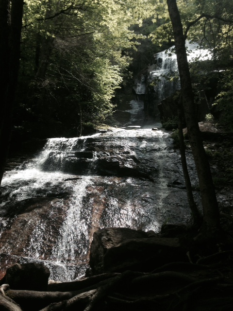
Jones Falls. Totally worth the extra walk.
The view from on our way up to Mountaineer Shelter.
Day 48 – Mountaineer Shelter to Laurel Fork Shelter
Miles: 17.8
Today was a long day, but mostly mentally. Even though we kept a good pace all day, I found myself growing irritable. The mental game is definitely harder than the physical aspects of the trail, and while I prepared as best as I could, today was a struggle for me. One item I have noticed contributing to that is that cell service has been absent the past two days. When I was able to get a few text messages through to people back home at lunch, my mood immediately changed for the better. Apparently, I am more connected to a few people than I thought I was! In fact, I was in such a good mood, the afternoon seemed to slip away from me, until we hit the treacherous downhill rockslide that leads to Laurel Falls. But the falls were beautiful. Not as good as Jones Falls, in my opinion, but some of that may be because we were rushed by darkness and a crowd of people behind us, so the shadows had set in and the mood was a little less wonderful than it might have been in full daylight. We walked on to Laurel Fork Shelter, which left a lot to be desired. We were the only ones there, but even so, it was hard to find two tent spaces at this shelter. Bookie ended up setting her tent up inside the shelter.

Laurel Falls.
Day 49 – Laurel Fork Shelter to Hampton to side trail crossing
Miles: 0.8 (6 miles off trail…)
Today was a nero day, but a long, hot one at that. Older Dog, Bookie and Star and I walked into Hampton, to get some resupply boxes from the post office and to resupply. We stopped for some breakfast at a small diner called Lon and Teresa’s Grill, which provided wonderful food. We stopped at the dollar store for extra resupply items, hit up McDonald’s to use some WIFI and charge a few batteries, and then Subway for lunch. It was a long boring day but good for the joints to rest, too. I was able to call home and check in, too, which always helps the mental game. We walked back to the trial and were at camp by 6, with Trail Chef waiting for us there. Since we weren’t able to shower in town, we took the extra evening time to bath in the stream. It was cold and not great cleaning, but it certainly felt good to wipe away some of the trail grime from the previous few days.
Day 50 – side trail crossing from Hampton to Vandeventer Shelter
Miles: 15
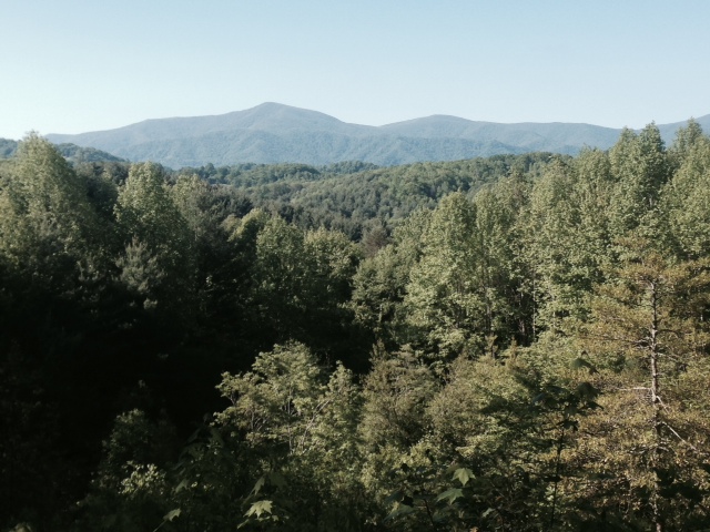
As always, today started with an uphill. And not just any uphill, but a long, 1,722-foot elevation gain hill, leading to Pond Flats. By the time we reached the Recreation Area three hours in, I was nearly spent. Thankfully, we had agreed to take a longer lunch break there, as it was Memorial Day weekend and we wanted to relax a little. Trail Chef was having some knee issues, so Older Dog hung back with him, while Bookie, Star and I hiked on at our normal speed. Sitting in the rec area for two hours, watching the families having cookouts, the boats, the kids swimming, really made me homesick for Michigan summers. It has made me realize how much I love having lakes and rivers around, something Maryland is lacking in. After lunch, we had another big uphill (1,600+ -foot elevation gain) to reach the shelter. When we got there, the shelter and tent spaces were full, but we had learned from Rikki Tikki (who yellow-blazed after the hostel and was now one day ahead of us…) that there was a nice campsite halfway down the steep blue blaze trail for water. Bookie ran down (literally, asthma attack and all…) and checked it out, verifying it would work great if we were ok with the steep hill. We left Trail Chef up top, taking his empty water bottles so we could fill them for him, and the other three of us camped down the blue blaze trail. Today was a long, difficult day, leaving my right knee pretty sore from all of the steep uphills. Hopefully, the hills don’t kill me before I make it to Maine.

Watauga Lake.
Day 51 – Vandeventer Shelter to Double Springs Shelter
Miles: 14.4
Today was another long day, albeit one with good views. Trail Chef’s knee was still bothering him, and towards the end of the day, he decided his time was up. He made arrangements with Miss Janet to get back to town tomorrow, and is headed home to rehab his knee again. Just before the handicap access trail at TN-91, we came upon G-Hippie and his Westy serving trail magic at the road crossing. He hot dogs, soda, beer, chips and carrots, which made for an amazing afternoon snack. We hiked the last three miles with full bellies, got to camp, set up, ate a small dinner since we were all still full from the trail magic, and headed to bed. Bookie was starting to have more shin pain today, and is worried about what it will mean for her hike. Today, I also had the realization that I don’t roll my ankles much anymore. Whereas it used to be a daily thing, I can’t remember the last time I did roll an ankle, and that small improvement made me smile a little. Out here, it is certainly the small items that you need to celebrate.

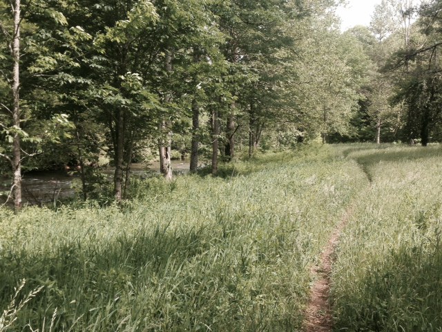
The fields just past TN-91.
Day 52 – Double Spring Shelter to unnamed campsite
Miles: Approx. 13
It started raining about 4am, which always makes me cringe at the extra mess and weight of the wet gear, but it stopped by 8:30 or so, and was sunny by 10, but very humid. I had very low energy today, the result of my small dinner last night, I am sure. I know I should’ve eaten, and will have to force myself to do so in the future, even if I’m not hungry. We took a long lunch at Abingdon Gap Shelter due to a quick rain shower. There was no single bad hill today, but the series of quick ups and downs all day wears me out just the same. Bookie’s leg was hurting bad by mid-afternoon, so we stopped early at an unnamed campsite along the trail. It seems we have hit a point where everyone’s mood and enthusiasm is starting to degrade, along with our beaten bodies. But I know we will be in town tomorrow, so I am not too worried… for now.
Day 53 – Campsite to Damascus
Miles: 6.6
It was a quick walk into town today. Quickly, we passed into Virginia! Another state down. Bookie has a friend from New Hampshire, Annie, that recently moved to Damascus and was kind enough to let us set up tents in her back yard. We went into town and got breakfast, did our post office pickups, got showers, went back into town for lunch, and then went to the grocery store for our resupply. Annie made us a wonderful spaghetti dinner, which we ate on the back lawn under a big tree. Town days are never as productive as you plan them to be, but even so, I still was able to get a lot done, just not all of it (like writing this blog!).

Finally into Virginia!
Day 54 – Damascus to campsite
Miles: 4
I must admit, it’s hard to sleep in a backyard in the middle of a town when you are used to woods! There were lights and cars and noises and dogs barking and all the normal town noises… but boy, was it hard to sleep through! I woke up this morning to a semi-flat sleeping pad. Again. Stress #1. Annie took us to Abington, to do laundry, since Damascus doesn’t have a Laundromat and her washing machine hasn’t been delivered yet. But all New Hampshirians must like to talk a lot (Bookie is the same way!), so we were half an hour later to leave than planned. Stress #2. Laundry went quick, and we decided to treat Annie to breakfast while we were there. Back at her house, we packed up our bags, did a quick post office drop, and I walked ahead to Sundog Outfitters, to get my sleeping pad replaced. Shout out to Sundog for the easy and quick replacement! As is usual for a town day, we got a late start – Stress #3 – and didn’t leave town until almost 2pm. So walking out of town, I was already in a bad mood. And the uphill immediately out of town didn’t help matters for me. We got about two hours into the hike, where we reached a stream crossing, and as we filtered water, the skies got dark and thunder started to rumble. We also noticed a detour sign just past the stream. Wasn’t aware the trail could have a detour, but apparently, it can. We decided to find the next available campsite and make camp, hopefully before the rain started to fall. Thankfully, we found one about fifty yards down the detour trail. We quickly set up camp just as the rain started. Once again, we hid in our tents for about an hour while it rained. I took the opportunity to read my kindle, trying to unwind and de-stress. It worked, mostly, although the stress made me a little irritable for the remainder of the day. Dinner was a wet affair, as the trees dripped on us, but the rain held off until we were back in the tents for the night.
Day 55 – Campsite to Whitetop Mountain Road
Miles: 16.5
We were all slow to get moving in the morning, with the rain still drizzling down on us, but eventually the rain moved on as we walked along. The morning was an unremarkable hike, but the day turned sunny and warm, at least for a little while. We reached the Virginia Creeper Trail crossing and had lunch at Trestle #34, right next to a stream. Bookie went for a quick dip in the stream, while I just waded in a little to soak my feet. Before we left, Rikki Tikki played a little flute music for us. After lunch, there was a long uphill climb to the campsite, with a 2,000-foot elevation gain. Which means we were all exhausted when we reached camp, with both of my knees sore. Thankfully, there was a decent view just before the campsite, and a great water source to filter from. We set up camp, ate dinner and headed to bed.

Trestle #34 along the VA Creeper Trail
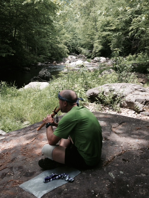
Rikki Tikki playing his wooden flute
Day 56 – Whitetop Mountain Road to Grayson Highlands State Park (northern boundary)
Miles: 11.9
I woke this morning with stiff knees, something that is becoming a normal occurrence for me. But I wasn’t alone today, as everyone seemed to be moving slower than normal. Rikki Tikki graced us with some wooden flute music as the sun rose in the sky, which always makes us pause to listen. The walk today was slower than normal, due to the trail being very rocky. We had lunch on the summit of Mt. Rogers, which I must say was a tad underwhelmed. The highest point in Virginia, and there wasn’t a view, or even a decent clearing, just a boulder in the middle of the woods with a USGS marker on it. After lunch, we entered the Grayson Highlands, anticipating the ponies there. Unfortunately, the first set of ponies we saw were chased by a day hiker’s dog and ran off, kicking the dog in the head in the process. Star was on best behavior, thankfully. I know I shouldn’t be surprised that people would have an untrained dog unleashed, but it was sad that the dog had to get kicked for the owner to realize maybe the leash would be a good idea. Thankfully, the dog showed no immediate signs of injury, although we discussed the potential for future issues. AS we continued to walk, we came across a pony with her young colt standing immediately off the edge of the trail. We watched them for a while, waiting for them to move on. And as if today didn’t have enough excitement, we passed the 500 mile marker! Bookie let out a loud scream, startling a group of day hikers in the process. We took the obligatory pictures with the stone numbers, then moved on. But the rocks were starting to take a toll on our feet, and we ended up cutting our day short by a few miles. We found a beautiful campsite just outside the “no camping” zone of the State Park, and set up camp with a few other thru hikers. My knees did feel better as the day went on, but any large “stair steps” were tough to navigate. All in all, though, it was a good day. There was a large stream near the campsite, and while filtering water, a husband/wife team walked across the bridge with their two young daughters. Bookie and I had about a ten minute conversation with them, and found out the two parents are teachers. They have decided to spend their summer vacation doing section hikes of the A.T. and other trails along the Eastern Seaboard. The girls weren’t carrying any gear, which allowed them to explore and be infected with the love of nature, and I could already see it brewing! I made sure to mention to them both that they are doing a wonderful job of parenting, as I watched the girls jumping around the rocks and exploring the paddle bugs on the water’s surface. It brought a smile to my face, and my soul, to see two young children with an obvious love for the world. I think that’s what this world needs more of.

The Grayson Highlands

The Grayson Highlands

500 Miles!
Day 57 – Grayson Highlands State Park (northern boundary) to Trimpi Shelter
Miles: 19.1
Knowing we had miles to make up, we got up early for a planned long day. I hiked mostly with Bookie and Star, although Rikki Tikki and Older Dog were close behind. Shortly after leaving camp, Bookie and I came across the family from last night as they were finishing their packing up. We stopped to chat for a few minutes, and engaged both of the girls in some more excited nature talk. They were so enthusiastic over the smallest discoveries. What an amazing experience these parents are giving their daughters. A+ job, for sure. But having a long day planned, we hiked on. There were a couple big hills but the trail was decent otherwise. Well, except for the rocks. The rocks under foot were horrible, causing you to either stare at the ground constantly or risk a twisted ankle or knee. We saw another foal and momma pony, this time at a longer distance away. But what a long day it turned out to be! My right hip became sore from the odd angles it took to maneuver around the rocks, and both feet were sore. My knees seemed to be ok, with regards to pain, but they were both tired by the end of the day. To make matters worse, it started raining about 3, and while it let up just long enough to set up our tents, it started back up and didn’t let up at all until later in the night. We made it to camp exhausted, set up tents quickly, ate dinner in the rain, and were quick to get into our tents. I tried to read for a little while, but sleep seems the better option.

Foal and momma
Day 58 – Trimpi Shelter to Mt Rogers Visitor Center (Marion, VA)
Miles: 9.9
While it seemed like a shorter day due to the mileage we had planned, the longer day yesterday took its toll on us today. We got up and out of camp at a pretty decent time, and kept a steady pace, albeit seemingly slower than normal. It started to rain a little about 11, but not bad enough to really worry us. We got to the Visitor Center and called for a shuttle, but knew it wouldn’t be there for a while. While waiting, Whiz Bang and Shine On came up, having just hitched back from town. We hadn’t seen Whiz Bang since Trail Days, so it was great to see her! Shine On is a fellow Michigander than I met at Trail Days, and while I didn’t get to talk to her much, I know she’s the type of person I would get along with. Shortly later, it started pouring rain, making Whiz Bang and her group pause before heading back on trail. During this pause, Whiz realized she had left her cell phone at the post office in town. She immediately dismissed it as a lost cause, but we said we would check when we got into town. The shuttle finally arrived, and we made our way into Marion. We got a hotel room, went to the post office (where we all forgot to look for the cell phone!), got showers, and went to dinner. During dinner, I received a Facetime call from my niece, which always puts a smile on my face! We stopped at Wally World on the way back from dinner, to resupply, and then I made calls home and repacked my bag. Needless to say, it turned into an extremely late night, especially for hikers! Older Dog informed us tonight that he intends to increase his daily mileages, with a goal of being our of Virginia by the end of June, which means he won’t be hiking with us anymore. One by one, the group gets smaller.
Day 59 – Mt Rogers Visitor Center to Chatfield Shelter
Miles: 6.6
Knowing we needed to make mail drops at the post office this morning, we were able to sleep in a little. We all went to breakfast together, and then walked to the post office – where I found Whiz Bang’s found sitting on a brick ledge! I immediately texted Shine On, to let them all know, and stashed the phone in my pack with the intentions of catching up and getting it to her. I stopped at Verizon quickly to buy a Lifeproof case for my cell phone. I am tired of having to stash my cell phone away whenever it rains, and missing out on lots of good pictures. Then we caught the shuttle back to the Visitor Center. Doing our last minute packing at the Visitor Center, Bookie realized she had left Star’s dog collar on the shuttle. She made a phone call to them, and they said they would bring it back up on the next scheduled stop. Unfortunately, that meant a three hour wait. Older Dog and Rikki Tikki hiked on, while I waited at the Visitor Center with Bookie, utilizing the down time to try to catch up my journal. With the longer miles and later days we have been pulling, I have neglected my journal in exchange for more sleep. Once we started hiking (uphill, as always), we made decent time. Bookie and I had lots of good conversation, which helped the hike go quickly. It rained on us for about two hours while we hiked, but had mostly stopped by the time we got to camp. And we had our first two true river crossings today, where you had no choice but to wade in to get across. Thankfully, the water was only mid-calf muscle deep, as the rain had turned the rivers into raging torrents of water! But it was fun, nonetheless, bringing out the inner child in me as I splashed and stomped my way through the water and mud. The rain did make for a cooler evening, though, so I was quick to eat and get into my dry clothes and warm sleeping bag.

Random AT sign
Day 60 – Chatfield Shelter to VA-42
Miles: 16.7
It rained on and off most of the night, but had pretty much stopped by morning, although the trees were still dripping for a while. We all had a slow start due to the wetness and the chill in the air. Bookie, Star and I started out ahead of Older Dog and Rikki Tikki, but that only lasted about an hour, when we reached the Lindamood School at the Settlers Museum. This historic single-room school house is maintained by the park service now, but inside, they allow trail magic to be left for hikers. While we were enjoying some of the fruits of the magic (and trying to warm up from the cold, wet weather…), an SUV pulled up outside. We looked outside, and were met with friendly smiles and warm greetings, as the trail angels in charge of the school’s offering came in to resupply the gifts. Through discussion, we discovered we had met two of the trail angels, Rick and Carol Lindamood, at the Visitors Center two days prior, when they offered us a ride down the mountain. They only had room for two people, and since our group had four plus the dog, we had passed the offer to another hiker. We all helped them move the groceries from the SUV to the school house, and then engaged in a long conversation about the trail, about trail magic, and then about the school house itself. Rick’s grandfather, as it turns out, used to be the teacher in this very school house – hence the name, Lindamood! He gave us some history about the area, and the school, about how the family had donated it to the museum, which was then taken over by the park service. It was absolutely amazing to actually meet the angels responsible for the trail magic, and even better was the historical connection to the school house! We all left with a skip to our step. We continued our hike into Atkins, where we stopped for lunch at The Barn Restaurant. While the food wasn’t truly anything out of the ordinary, it was hot, delicious, and relatively inexpensive. They even brought out some bread and gravy for Star! We left Atkins with dryer weather, and hiked through fields and cow pastures. We could see a storm building and the clouds chased us across a few fields, but the storm never truly hit. Small blessings. We got to camp a lot later than we had hoped, and had to set up tents and cook dinner in the dark. But it was worth the later finish to spend some time at the school house and to get a hot meal in town.
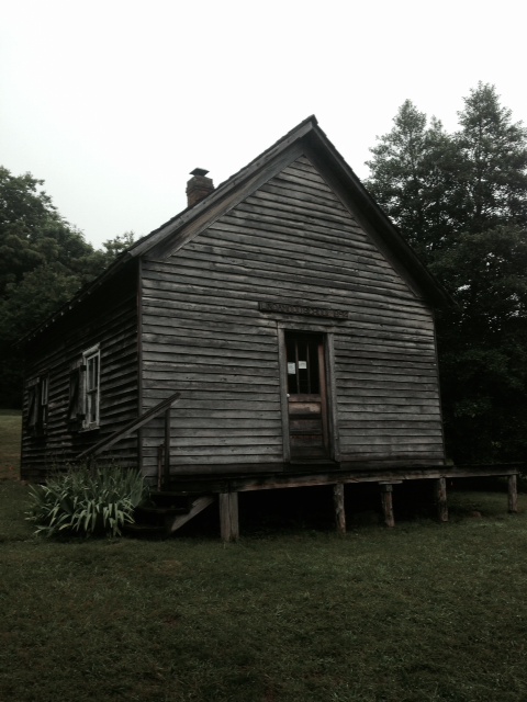
The Lindamood School House

Inside the school house

Trail angels: (L to R) Carol and Rick Lindamood, Wanda and Ralph Brewer, with grandson Cash Brewer.
That’s it for now. Promise to keep the updates flowing as fast as I can find internet! Until then, remember to Spin the Compass.

This website contains affiliate links, which means The Trek may receive a percentage of any product or service you purchase using the links in the articles or advertisements. The buyer pays the same price as they would otherwise, and your purchase helps to support The Trek's ongoing goal to serve you quality backpacking advice and information. Thanks for your support!
To learn more, please visit the About This Site page.
