 ">
">
Rain, Rain, and Rain: A Look at Weather on the AT
Despite our best efforts, we’ve all found ourselves caught unprepared when the weather had a change of heart. “But the App said it wasn’t going to rain!” you protest to the sky. Of course, the sky can’t hear you. It doesn’t have ears. What it lacks in auditory appendages it makes up for in fury, lashing you with sideways rain and deafening thunder.
If this sounds familiar, you hopefully learned an important truth from it and came away none the worse. If this doesn’t sound familiar, if you’re thinking, “That won’t happen to me!” I’ve got news for you. Despite what you may think, you don’t know better, you’re not smarter, and it will, without a single doubt, happen to you eventually.
The reality is, weather is exceedingly hard to predict. According to the National Oceanic and Atmospheric Administration (NOAA), the typical five-day forecast is roughly 80 percent accurate, while the typical 10-day forecast is about 50 percent accurate. Beyond that time frame, the reliability drops off precipitously.
Even with advancements in meteorology, accurate forecasting is still a challenge. Add the volatility of mountain weather and a lack of reliable cell service through which to receive forecast updates, and you can imagine how easy it is for a hiker to be caught unprepared.
With that in mind, let’s take a look at why the weather is such an unpredictable factor on the Appalachian Trail.
Author’s Disclaimer: I am not a meteorologist. My knowledge of this subject comes from a combination of my Master’s in geography, experience as a backpacker and Search and Rescue team member, and sheer passion for the subject.
The Big Picture
Most weather patterns in the Lower 48 travel roughly west-to-east and are relatively easy to forecast. They’re often the product of pressure systems. You may hear meteorologists talk about “low-pressure systems” and “fronts.” Air wants to move from areas of high pressure to those of low, but due to the Coriolis effect, they can’t move straight there. Instead, the air spins around, slowly moving toward the low-pressure center. It’s like the water emptying from a toilet bowl, just spinning on a massive scale.

Basic diagram of a low-pressure system showing the movement of different air masses around it. (Courtesy: National Weather Service.)
These large-scale systems are what move cold and warm air around. Cold, dry air from Canada and the Arctic gets pulled down and around the low-pressure system as the whole thing rotates. At the same time, the system pulls warmer moist air from the south. It’s these rotating masses of cold and warm air and their interactions that generate the weather we experience on the surface.
Cold fronts and warm fronts generate most of the weather that significantly affects us. As a mass of cold air moves around the system, it will eventually collide with warmer air ahead. The colder, heavier air acts like a wedge and pushes the warmer air up as it passes. When the warmer air is forced up by the cold front, it develops into powerful storms and can produce severe weather.
Warm fronts, by comparison, are much gentler in their process. Because the air of a warm front is less dense than the colder air it is overtaking, it is a slow process that generates clouds for hundreds of miles and lighter, steady rain as it passes.
Under Cloud Nine: Understanding Clouds
I’m not going to dive very deep into reading clouds here, mostly because this is an article, not a book. But also because for the purpose of reading the skies you only need to know a few types of clouds and how to identify the cloud base height.
There are a total of 10 primary cloud types, often named for a combination of characteristics.
Cirro- as a prefix indicates high-elevation clouds (cirrus, cirrostratus, etc.) and these clouds don’t tell us much about the weather by themselves. They’re so high in the atmosphere that they’re actually made of ice crystals rather than water vapor.
Alto- clouds are the mid-level clouds. Like their upstairs neighbor, cirro-clouds, they don’t tell us much by themselves. It’s the upward or downward movement of the alto-cloud base that tells us what we need to know as hikers. If the cloud base is descending, it’s usually a sign that rain is on the way.
The clouds that we need to worry the most about are all found closest to the ground.
Nimbostratus clouds are the wide sheets that produce lighter but more consistent rain, possibly over a broad area.
Cumulus are the puffy clouds we know and love. The ones we spent our childhoods looking for shapes in. But when the atmosphere becomes unstable due to temperature and pressure changes these unassuming clouds grow and coalesce into larger and larger clouds until they form towering cumulonimbus clouds.
Cumulonimbus clouds are the original “cloud nine.” When the clouds were first given their names, the giant cumulonimbus clouds were the ninth cloud. To be happy, or elated, became know as being on “cloud nine” because you felt as though you were at the top of the tallest clouds.
When Clouds Come Down to Play
The frontal systems we talked about earlier are responsible for changes in the elevation of cloud base. As a warm front comes rolling in, clouds form at the altitude at which the air masses are interacting. Warm air, being lighter than the cold air ahead of it, starts off higher up and filters down—and so do the clouds. They start off as wispy high-altitude clouds and descend slowly as the front approaches. Eventually resulting in rainy stratus clouds.

Eight of the most common cloud types and their relative elevations. (Courtesy: National Weather Service.)
The opposite happens with cold fronts. The clouds that produce weather are found at the leading edge. As the cold front hits the warm air cumulonimbus clouds form. As the cold air advances and the boundary between it and the warm air rises higher the clouds rise with it before eventually fading altogether.
Bottom line: if the cloud base drops during the day, expect rain. If it’s climbing, you can likely expect improving conditions. If the cumulus clouds start to grow, especially vertically, storms will likely follow in the next few hours. Start planning for shelter.
Up and Over: Weather in the Mountains
Predicting the weather on the trail wouldn’t be so difficult if all you had to worry about were frontal systems. But along the ridges and down in the gaps of the Appalachian Mountains, you have to factor in the topography and relative location.
There’s Cold up in Them There Hills!
Let’s start with one of the constant effects of topography. No matter if it’s rain or shine, the temperature is influenced by the mountains. If you’ve ever hiked before, you’ve no doubt noticed how much colder it can get at the top of a mountain. This is due, like many aspects of weather, to atmospheric pressure.
Our atmosphere is often compared to an ocean of air above us. Like an ocean, the pressure is highest at the bottom. As you climb to the summit of a peak the air is thinner, the pressure is lower, and thus the amount of heat transfer is reduced. This drop in temperature actually happens at a very consistent rate of roughly 3.5°F for every 1000 feet you climb. So if it’s 60 °F in the valley at 1000 feet, then the summit, at 5000 feet would be roughly 46°F.
Rain for Every Occasion
“No pain, no rain, no Maine.” There is a reason for rain to be included in the saying right up there with pain. The AT sits in a meteorological sweet spot for much of its length. As I mentioned above, topography plays a huge role. But it’s two specific elements of that topography that create the meteorological conditions we love to hate along the trail. Look at the map below and you may spot the two common features of the trail: height and relative isolation.
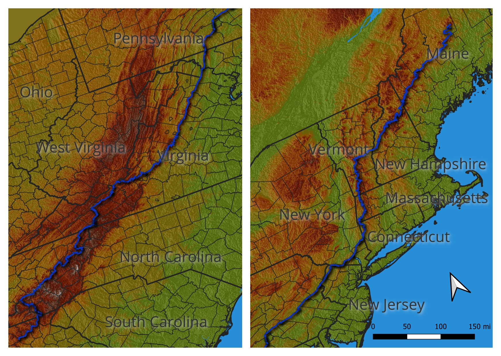
This map shows the route of the AT and the relative elevation profile along its length. (Map by: Geoff Hutton)
First, it’s where the height is. As air moves across the mountains, it has to climb over them just like you and I do (a process known as orographic lift). The air cools as climbs, and as it cools, it will eventually reach what’s known as the dew point: the temperature at which no more water vapor can be supported by the air. This forces water vapor to condense into clouds and possibly precipitation. If the air is lifted violently enough, it can even produce storms.
It’s this orographic lift that makes the weather so unpredictable in the mountains. Warm air may pass over the lower elevations without a single cloud forming. But when it hits the ridges, suddenly clouds burst forth and rain pours down.
By the time that same mass of air descends the other side of the mountain, it will have lost a portion of its original moisture, and the clouds and any precipitation will disappear. The far side (leeward side) of a mountain range gets less rain than the “windward” side (the side the storms approach from). Meteorologists refer to this region of less rain as a rain shadow.
The relative isolation of the ridges the trail follows also plays a part in the conditions. Of course, many parts of the AT are deep in the wilderness, especially from the view of hikers. But from a broader geographic perspective, the Appalachian mountain range is relatively narrow. The Blue Ridge Mountains, where the trail spends a lot of time from northern Georgia through southern Pennsylvania, are even more so.
Some mountain ranges are so vast that rain shadows exist within the range itself or are so dominant that they create full-on desert conditions on the leeward side. The Sierra Nevada’s enormous rain shadow, for example, is largely responsible for the desert conditions found in Nevada.
In contrast, the smaller stature of the Appalachian Mountains creates a much midler rain shadow effect. Shenandoah Valley is technically in a rain shadow. However, it still allows enough moisture through that Shenandoah National Park, sitting is still subject to rain from both directions. Gulf moisture from the west and Atlantic moisture from the east both condense into clouds and precipitation when they hit the mountains thanks to orographic lift.
Yet even in the Appalachians, ridges get more rain. The average annual precipitation for Gatlinburg, TN from 2006 to 2020 was a respectable 58.4 inches. Yet Mount Le Conte, a scant six miles away, but 5000 feet higher, receives an average of 80.5 inches of precipitation every year. It’s all in the elevation.

When the Sky Gets Angry
Sometimes, orographic lift is strong enough that it doesn’t just create clouds and rain; it creates storms. Storms are the true danger for hikers. Sure, rain has its own risks, but they’re not difficult to mitigate. But the high winds, hail, and most importantly, lightning that can come with storms are much harder to protect yourself from when caught unawares.
Updrafts, which occur when warm air is lifted rapidly—either by orographic lift in mountains or by frontal movements—can generate the towering cumulonimbus clouds mentioned earlier. At high altitude, that warm air will eventually cool enough to sink again. And as it falls back to the surface, it spreads outward, generating the strong winds associated with storms.
Sometimes these winds can be enhanced by cold air behind the storm, forming powerful systems known as derechos. These can travel vast distances and produce winds in excess of 120 mph.

In 2012 this Derecho tore across several states (and a large swath of the AT) over the course of just ten hours. (Courtesy: National Weather Service.)
These powerful updrafts can also create hail. If the upward winds are strong enough, they will catch ice crystals falling from the top of the storm and send them back up. As they rise, more ice will accumulate around them. They will continue this process of falling, lifting, growing, and falling again until the weight of the hailstones is too much for the updraft. The stronger the updraft, the larger the hail.
Thunderclouds
A sign of a strong updraft is the height of the storm. Of course you won’t be able to tell the height of the clouds once they’re on top of you. But if you see a towering thundercloud in the distance heading toward you, it’s possible to gauge the strength by whether or not the iconic “anvil” shape has formed.
The classic anvil develops when the updraft collides with the tropopause—a level of the atmosphere at which the temperature no longer drops with increased altitude. The air has a stable temperature at the tropopause. When you look out at thunderclouds and see that distinctive anvil shape, you’re also seeing the boundary between two levels of the atmosphere: the troposphere and the stratosphere.
More importantly, you’re seeing a sign of an extremely powerful storm, and you need to start looking for shelter immediately.
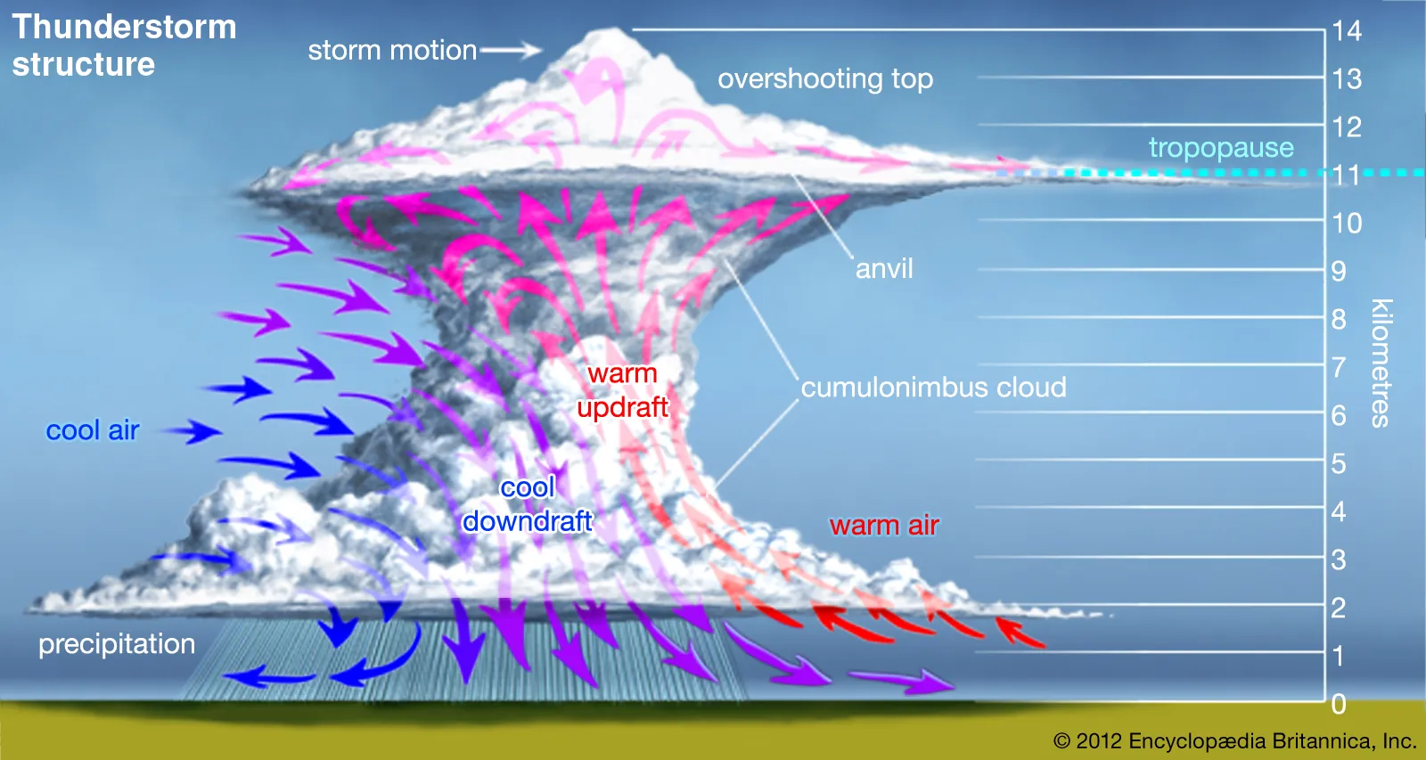
Depiction of a classic thunderstorm showing the flow of the updraft and downdrafts within. (Courtesy: Encyclopædia Britannica.)
The movement of frozen water molecules within the cloud creates static electricity. This electricity builds and builds until the negatively charged molecules attempt to balance themselves by reaching out for an area of positive charge. Usually it finds this within the cloud structure, never reaching the ground. This type of lightning is called cloud-to-cloud lightning.
But for every four cloud-to-cloud lightning bolts, one will strike the ground to connect with the positive charge found there.
A further note on anvil clouds and strong thunderstorms: when a storm is strong enough that the cloud has reached the anvil stage, lightning can strike far ahead of the storm. The National Weather Service (NWS) states that it can travel 10-12 miles. Other sources suggest that it’s not unheard of for lightning to strike 30 miles out.
When faced with an approaching storm, don’t be complacent because it seems far away. The term “a bolt from the blue” refers to lightning that appears to come from a blue sky because it has traveled so far ahead of a storm before striking the ground.
Lightning Safety Tips
Lightning is far and away the deadliest, most unpredictable aspect of a thunderstorm. Deaths attributed to rain, wind, and hail are relatively rare. Lightning, on the other hand, kills 10% of people struck. If you’re lucky enough to survive, there is a good chance of long-term injuries and trauma. With that in mind, I want to leave you with some important safety tips when a storm approaches.
If you can see lightning and hear thunder, count how many seconds it takes for the thunder to arrive after a flash. Dividing this number by five should give you the rough number of miles the storm is from you. More importantly, if you keep doing this, you can gauge whether a storm is moving toward or away from you.
Most thunderstorms develop in the afternoon after three p.m. Plan accordingly if storms are in the forecast.
Lightning takes the path of least resistance and likes to strike taller objects. This doesn’t mean you’re safe just because you’re in a forest. The charge is so great in lightning that it can still jump from the tree to you on its way down. Try to move downhill, into gaps or depressions so that there is more terrain above you.
If all else fails, assume the “lightning position.” Stand with your feet together, arms close by your sides. If you or something close by is struck by lightning, this allows the current to pass through you as quickly as possible. Conventional wisdom says to crouch down in this position, but the benefits are debated. Whatever you do, don’t lay down flat on the ground. That increases the chances of a close strike electrocuting you through the ground.
Parting Words
I hope this information can make you better informed and better prepared for your next excursion onto the trail. Whether it’s a thru-hike, a day hike, or something in between, we’re all at the mercy of the weather. Check the forecast before you head out, but be prepared for anything.
Some subjects were omitted for length and specificity. Of course snow, ice, heat, and any number of other weather phenomena are possible on the trail depending on latitude and season. I chose to focus this article on the most common issues, the ones that affect the largest proportion of AT hikers in a given year.
If you wish to learn more, I highly recommend the NWS education page (found here). They provide free videos, classes, articles, infographics, and more that explain nearly all aspects of weather. It’s a tremendous, and overlooked, resource.
References / Further Reading
Ahrens, C. D. & Henson, R. (2017) Essentials of Meteorology: An invitation to the atmosphere (8th ed.). Cengage Learning.
Henning, R. (2019) Field guide to the weather: Learn to identify clouds and storms, forecast the weather, and stay safe. Adventure Publications.
Krider, E. P. (2020, October 29). Thunderstorm. Encyclopedia Britannica. https://www.britannica.com/science/thunderstorm
Lockhart, G (1988) The weather companion: An album of meteorological history, science, legend, and folklore. Stephen Kippur.
National Oceanic and Atmospheric Administration. (2022) How reliable are weather forecasts? NOAA SciJinks. https://scijinks.gov/forecast-reliability/#:~:text=The%20Short%20Answer%3A,90%20percent%20of%20the%20time.
Pretor-Pinney, G. (2007) The Cloudspotter’s Guide: The science, history, and culture of clouds. Tarcher Perigee.
Walker, G. (2007) An ocean of air: Why the wind blows and other mysteries of the atmosphere. Houghton Mifflin Harcourt Publishing Company.

This website contains affiliate links, which means The Trek may receive a percentage of any product or service you purchase using the links in the articles or advertisements. The buyer pays the same price as they would otherwise, and your purchase helps to support The Trek's ongoing goal to serve you quality backpacking advice and information. Thanks for your support!
To learn more, please visit the About This Site page.

Comments 2
Great info, nice detail! My husband & I hike and also long-distance canoe camping. Weather & reading the sky/clouds very important on the different bodies of water.
Your info will come in handy for all our trips, thanks so much,
“.com”
I am completely surprised that you did not mention that one needs to collapse their hiking poles and put them away in thunderstorm conditions. The man who has been struck by lightening more than any other was a forest ranger who traveled the ridges in national parks. He carried a rifle the entire time. While he survived, he was struck because he carried a lighting rod with him!
If you can see the lightening or hear it, put away anything that could attract the charge. Also remember that the charge is actually FROM THE GROUND UP, not the sky down. You may feel your hair rise or otherwise feel the chart BEFORE it happens. This might give enough time to save your life. I Know that I felt it on two separate occasions on the trail. Once when I was in a tree!