 ">
">
Reflections on My AT Thru-Hike
Summary
I started my southbound (sobo) thru hike at Mt. Katahdin in Maine on June 1, 2017 and finished at Springer Mountain, Georgia on November 26, 2017. Based on 179 days and 2190 miles, my overall average was 12.3 miles per day. I took 15 zero days, so for the days that I actually hiked, I averaged 13.3 miles per day. A marathon is a bit more than 26 miles, so think about averaging half marathons over mountainous terrain almost every day for close to six months. Most of those days I was carrying a pack that weighted 25 – 30 pounds (with food and water). The fewest miles in a hiking day was 1.4 and the most was 23.6. In Maine and New Hampshire, I averaged about 9.6 miles per day (not including zeros). After leaving New Hampshire, I averaged 14.8 miles per day (not including zeros).

Day 1
Health and Hygiene
After I returned home I was asked if I ever got sick during the nearly six months on the AT. The answer is no. I do not know why. My hygiene was not particularly good. I used hand sanitizer after every visit to the privy, but I never washed my hands with soap unless I was in town. I did not habitually clean or sanitize my hands before eating. Washing dishes was not an issue because I just heated water and poured it into a plastic bag for the food to rehydrate. If I had coffee or hot chocolate, I rinsed the cup and drank the rinse water. I licked my spoon clean before putting it with my kit.
I did meet people who previously had giardiasis or cryptosporidiosis. For thru hikers, it is generally not socially acceptable to shake hands. A fist bump usually sufficed when meeting someone or seeing someone off. There were only a few times when I did not filter water. This was only from piped springs; I always filtered water from lakes and streams. During a drought in Virginia many of the streams were not flowing and I had to get water out of remaining puddles. In these instances, I filtered and chlorinated the water.
I also met people who said they had suffered from lyme disease. During my time on the trail, I only saw one tick. It was on my leg after walking through a grassy area while still in Maine. I do not think it had been on me very long. It was one of the larger ticks and not the little deer tick that carries lyme disease. Starting out, I wore long sleeved shirts and long pants. I had treated my clothes with permethrin before leaving home. On July 21, I got new clothes (short sleeved shirt and pants with zip off lower legs) in Hanover, NH and I treated them with permethrin. I did not re-treat again after that. I wore the pants as shorts most of the time until the weather turned cool. The weather became very dry and the tick problem seemed to abate.
I used a head net when pestered by black flies (June in Maine), mosquitoes, and gnats. Insect repellent with deet helped when mosquitoes were bad.
Food
My weight dropped about 25 pounds during the first eight weeks, then stabilized – I actually regained about 5 pounds during the last two months. Since getting home, I regained about ten pounds. Occasionally I still experience hiker hunger.
Starting out, I planned to not cook. For breakfast I ate granola cereal with nuts and raisins and powdered milk mixed in and I drank cold coffee. Dinner was tuna or spam with mayonnaise on flat bread and remaining trail mix or other snack-like foods. During the day I ate protein bars and trail mix containing lots of nuts and seeds with M&M or some other form of chocolate.
I tired of cold food (and cold coffee) pretty quickly and bought a MSR Pocket Rocket stove. After getting the stove I ate Mountain House freeze-dried meals as often as possible and never got tired of them. In the morning I would eat eggs and in the evening I enjoyed a variety of meals with rice or pasta. Sometimes I would add tuna to macaroni and cheese. I also added a package of ramen to some of the Mountain House meals to add some bulk. Another meal that I liked was Idahoan instant potatoes with Spam and cheddar cheese. During the day I ate protein bars (my favorite was/is Gatorade chocolate caramel whey protein bars), and other snacks like gummy worms, rice crispy treats, peanut M&Ms, macadamia nuts (200 calories/ounce), cheese crackers or Fritos corn chips, cheese, beef stick, or whatever I could find when I resupplied.
Before starting, I thought that I would miss vegetables and fill up on them in towns, but when I was in town I fed on high calorie foods, like: pints of Ben & Jerry’s ice cream, pizza, super large hamburgers dripping with mayonnaise, steak and potatoes, pancakes, and occasionally a salad with blue cheese dressing. I was happy when I got back to the South and could get a big bowl of grits with breakfast.
Health Effects
My before and after blood pressure didn’t change – it generally runs 125-130/75-80. Cholesterol levels before were: Total – 212, LDL (bad) – 136, HDL (good) – 62; and after: Total – 234, LDL – 122, HDL – 96. Normal or “desirable” total cholesterol is below 200 mg/dL); desirable LDL is below 130, and desirable HDL is 60 or greater. The doctor told me that my total cholesterol is meaningless since my HDL is so high. My LDL dropped into the “desirable’ range.
The improvement in my blood cholesterol levels happened in spite of the high calorie, high fat, and high cholesterol diet, and, while hardly scientific, I attribute the improvement to weight loss and extreme amount of exercise.
Injuries
During the first seven weeks, through Maine and New Hampshire, I fell so many times that I lost count. My shins were constantly bruised and cut. I had pulled muscles and limped most of the time. I only got one blister, which got infected, but I took care of it with antibiotics.
After getting to Vermont, the trail seemed easier. I did not have any significant slips or falls again until day 150 when I slipped and fell on my left leg, twisting it under the weight of my body. I lay on the ground for several minutes afterwards while evaluating how bad it was. Since nothing was broken I was able to stand up to test putting weight on it. I was able to limp on another 5 miles to get to Uncle Johnny’s hostel near Erwin, TN. A snow storm was on the way, so I took a zero the next day and gave the leg a rest. The aching and limping continued for the remaining four weeks. After that fall, I was truly ready to be finished with my thru hike. Finish is the key word, I never considered quitting! The only way I would have quit would have been if I got injured and had to be carried off.
Memorable Times
Starting day
It would be hard to forget the first day. Paul “Ole Man” Renaud shuttled us from the AT Lodge in Millinocket to Baxter State Park where we checked in at the ranger station and got our passes to summit Katahdin. My pass was #29, so I think that means I was the 29th person in 2017 to register as a thru-hiker. I, like most hikers that day, left my pack on the screened-in porch of the ranger’s station and headed up Katahdin with a small day pack. After the round trip hike to the summit, I camped at Katahdin Stream Campground. In my June 14, 2017 blog, I provided a little more discussion of Katahdin and the 100-Mile Wilderness.
Mahoosuc Arm and Mahoosuc Notch
On July 2nd, Day 32, Old Timer and I hiked 5.1 miles from Speck Pond Shelter (mile 271.8) to Full Goose Shelter (mile 276.9). Mahoosuc Arm is a mountain peak with an elevation of 3770 feet. The hike from Speck Pond to Mahoosic Arm is a fairly easy 1.4 miles. From the Mahoosuc Arm peak the elevation drops 1605 feet over a distance of 1.5 miles to the north end of Mahoosic Notch. This down-slope section was steep and slippery and treacherous (at least t0 me). Mahoosic Notch is a scramble through a “jumbled pit of boulders” and described in the David “Awol” Miller AT Guide as the “most difficult or fun mile of the AT”. To me, it was the most fun and very enjoyable. I remember hearing water running beneath me through the boulders and the cool air coming up as if from air-conditioner vents in the ground. Even though the daytime temperature was warm, there were still patches of ice in places with persistent shade.
Hanover, NH
On July 21st, Day 51, we arrived in Hanover after a 1.4 mile hike from Velvet Rocks Shelter (Mile 440.7). As we entered town we met Fern and Gulley, a young couple who were in our “bubble” at that time. After a short chat we went to the Co-Op grocery and bought some provisions, then called a local trail angel to get a ride to the Sunset Motor Inn. While we were waiting for our ride, a gentleman came up to Old Timer and me and handed us each a pint of Ben and Jerry’s ice cream. Our ride came shortly after – our ice cream was devoured before we got to the motel. People in Hanover were extremely friendly – one of the most hiker friendly towns on the trail.
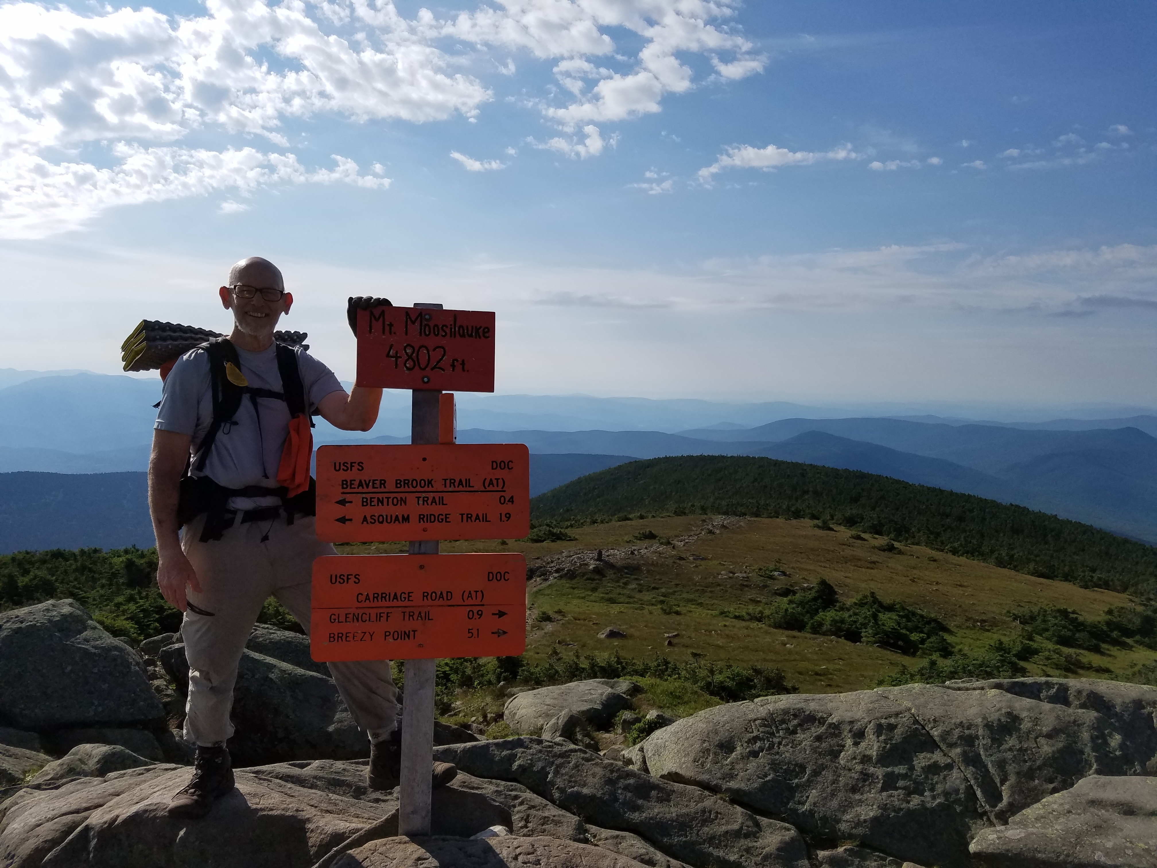
Mt. Moosilauke July 17, 2017 (Day 47)
The Hanover area also had a great public transportation system. I was able to catch a bus at the motel and get a ride to the Veterans Administration (VA) hospital in White River Junction, VT. My toe had an infection and was swollen to twice its normal size, so I went there to see if they could help. I went to the emergency room and presented my VA ID card, explained my situation, and asked if they could help me. They took my information and had me sit in the waiting room. I was the only one there. A few minutes later the nurse came and took me to a room to get my vitals. When he was finished he said the doctor would be there in a few minutes. Whereupon, the doctor looked around the corner, waved and said, “I’ll be right there.” When he came in he already knew my story and asked what, so far, was my favorite part of the trail. I told him Mt. Moosilauke (a 4802 foot peak I had summited on July 17th). I told him the reason I liked it so much was because it was such a beautiful day and the view was spectacular. He smiled and said that he had hiked there many times and that it was one of his favorite places. He looked at my toe, verified that it was infected (said I probably got some debris in it after the blister broke) then gave me a prescription for antibiotics that I was able to fill there at the hospital.

Sporting new clothes and boots leaving Hanover, NH
When I left the hospital, I boarded a bus which took me to the Eastern Mountain Sports store in West Lebanon, NH where I bought new pants, shirt, and Oboz hiking boots.
July 21st was a very productive day. The next morning, after a good night’s rest in the Sunset Motor Inn, we had breakfast at Lou’s diner (free muffin for AT thru-hikers), then hiked out of Hanover and into Vermont.
Duncannon, PA
September 3rd, Day 95, was the day I limped into Duncannon with both feet aching from the Danner boots that I had purchased 70 miles and 5 days earlier. I liked towns like Duncannon and Damascus where the trail passes directly through the town. My first stop in Duncannon was 3B Ice Cream on Market Street. I got a banana split. It was amazing – a very large serving at a reasonable price.

Doyle Hotel, Duncannon, PA
After ice cream, I hiked on to The Doyle Hotel where I got a room for 2 nights. The Doyle is a mess, some would say “seedy” and call it a “dive”, and it has some one-star reviews. I am sure the bare wires in some of the rooms are not up to code. Regardless of all of the downsides, I liked it. It was cheap and the food was very good and inexpensive. Some reviews say the owners were rude and dismissive. Some people just can’t take a joke. I thought the owners were friendly, but they did have a cutting sense of humor. I give as good as I get, and was quite happy to joke along with them. They seemed to appreciate that.

Photo of Laura and me on AT in Duncannon
In my September 12th blog, I told about my niece, Laura, coming to get me in Duncannon and taking me back to Cabela’s in Hamburg to return the Danner boots. Spending the day with her was definitely a highlight of my journey. We hiked together on part of the trail that goes through Duncannon (which I had missed when I came into town and hiked from the Ice Cream shop to The Doyle on Market Street instead of High Street). So, Laura, I had not previously been on the section of the AT that we hiked together.
Stanimal’s 328 Hostel Waynesboro, VA

Lady Bug, Carrie, and Prairie
September 22, Day 114, I hiked 7.7 miles from Calf Mountain Shelter (Mile 1320.2) to Rockfish Gap (mile 1327.9) where Adam picked me up and shuttled me to his hostel in Waynesboro, VA. When I got there, I met section-hikers Prairie, Lady Bug, and Carrie. They had a car and invited me to go along with them for shopping and dinner. I had a fun and entertaining afternoon with them. My wife calls it a “chick day.” One of the reasons that I wanted to go along was because they were going to a pharmacy and I wanted to get something for a callous on my right foot that I had developed when I was wearing the Oboz shoes that I got in Hanover. We went to the pharmacy, but the callous files there were too expensive, so I just got some liquid callous remover. We also went to Rockfish Gap Outfitters, and Walmart, so I was able to resupply. While in Walmart Lady Bug found an inexpensive callous file for me to buy. After shopping, we went to a restaurant. After telling them that I was doing this blog, they asked me to mention them in a submittal. I promised that I would. At the time I did not think that it would be six months later. I apologize, my friends.
When I got back to the hostel, I made arrangements with Adam to do a slack pack the next day, then I took my shower and applied the liquid callous remover and protective cover. Then off to bed. In the morning, I used my new callous file to scrape off the softened dead skin.
On the morning of September 23rd, Adam shuttled me to Reeds Gap (mile 1347) and from there I slack packed north 19.1 miles back to Rockfish Gap to stay a second night at Stanimal’s.
The next morning, my shuttle took me back to Reeds Gap. From there I hiked 57.9 miles over three days to arrive in….
Glasgow, VA
…on September 26th (Day 118). I got to U.S. Hwy 501 (mile 1404.9) late in the afternoon and contacted Stanimal’s Glasgow hostel for a 5.9 mile shuttle to Glasgow. After hiking 77 miles over the previous four days, I deserved a zero day.
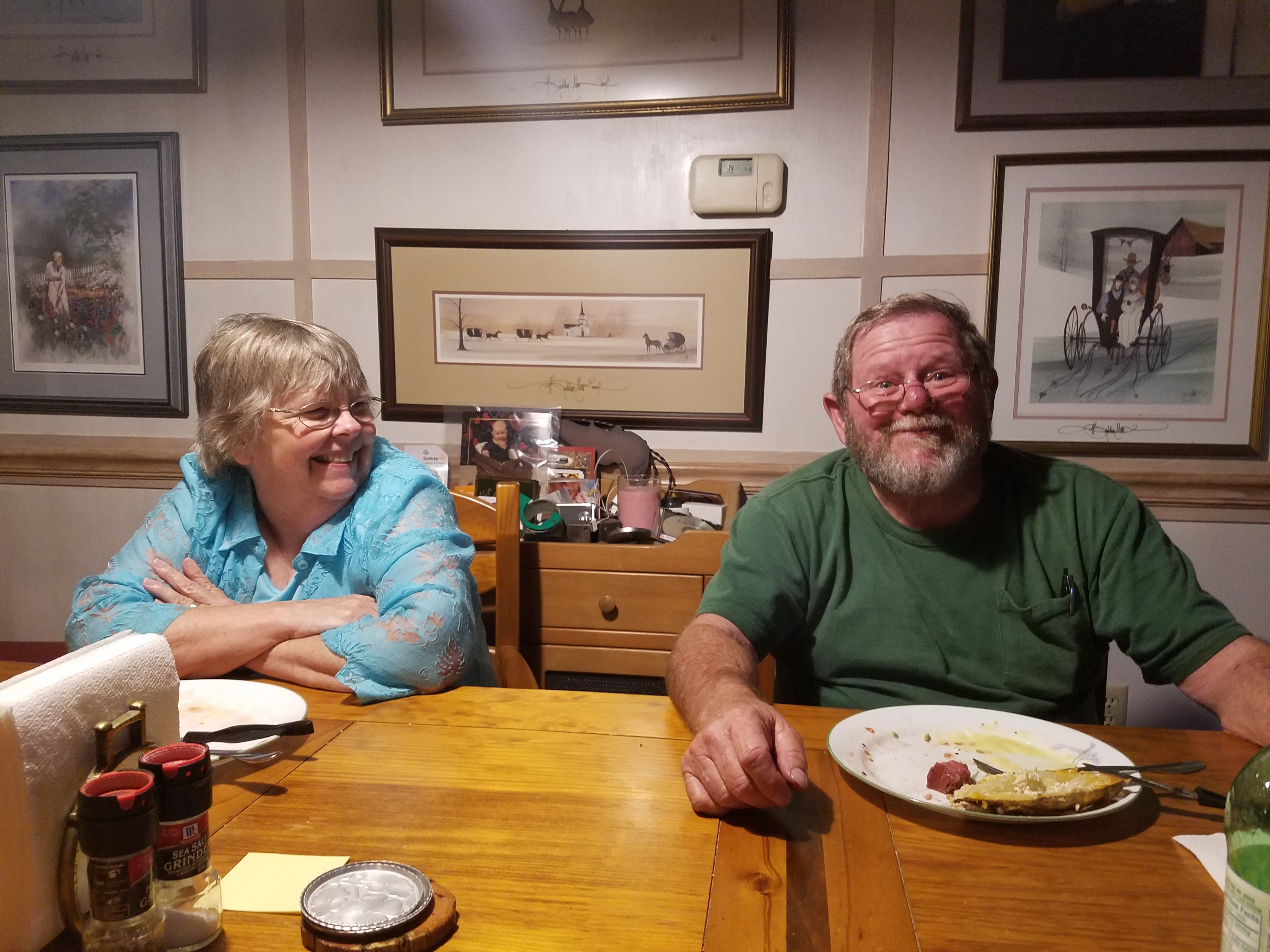
Neil and Judy Robichaux
I ended up spending three nights at Stanimal’s hostel in Glasgow. A high school friend, Neil Robichaux, lives in Glasgow and invited me to his house for dinner on September 27th. Judy, his wife, is a professional photographer and they had a commitment for a photo shoot, so after they finished Neil came and got me about 3:00 p.m. We had a nice visit and Neil treated me to delicious, perfectly cooked, steak dinner with tender asparagus and twice baked potatoes. With his nice beard, Neil could be a fellow hiker on the AT. They offered for me to spend the night, but I was already set up at Stanimal’s for an early morning shuttle to Blue Ridge Parkway (BRP) mile 76.3 for a slack pack hike.
On September 28th, I hiked the 14.9 miles from BRP 76.3 (Mile 1419.8) northward to U.S. Hwy 501. Again, I got a shuttle to Stanimal’s where I was happy to see my friend, Ghost Hiker. She was a flip-flop thru hiker who I had met while she was northbound. After she flipped (or flopped) she and I were in the same southbound bubble and occasionally stayed at the same hostels or crossed paths on the trail. I learned from her that Mountain House freeze dried meals can be rehydrated in Zip Lock Freezer bags (IT HAS TO BE THE FREEZER BAGS). So I emptied all of my freeze dried meals (removing and throwing away the oxygen absorber) and my Idahoan potatoes (divided into single serving portions) into freezer bags. This was a good way to reduce the volume in my food bag.
Erwin, TN

Hiking at night with head lamp
Obiwan was a hiker that was in the same bubble for the last 1000 miles, or so. On October 27th there was a warning that a snowstorm was headed our way. Obiwan and I hiked 22.9 miles from Roan High Knob Shelter to Beauty Spot Gap (Mile 1835.3). That would leave us only 11.8 miles to get to Uncle Johnny’s near Erwin, TN on October 28th (Day 150). We were up and on the trail before daybreak, Obiwan about 1/2 hour ahead of me. As I mentioned above under injuries, I twisted my leg about 5 miles before getting to Uncle Johnny’s. Nevertheless, I got there in time to catch the shuttle to town for dinner at Los Jalepenos restaurant. They had good Mexican food and excellent frozen margaritas. Then we had some time in WalMart until the shuttle came to pick us up.
Things that go bump in the night and other noises…
After getting back to Uncle Johnny’s we settled in for the night. There was a nice fire in the Franklin Stove and it kept the bunk room quite toasty. There was an old dog living in the bunkroom that pretty much owned the sofa. The dog had learned how to open the door to let himself out and could push the door open to let himself back in. When the spring pulled the door closed it made a loud bump. Sometimes it did not close and the cold air would roll in. Since I was in a bunk next to the door, I would get up and close the door. During the night noises came from up in the ceiling; someone said it was rats scrambling around.
Snow Day
On October 29th, Obiwan and I took a zero (Snow Day) and moved into one of the little cabins. The cabin was just about big enough to accommodate the bunk bed and our gear, and it had a little electric space heater. It was nice to have the day off and recuperate after twisting my leg the previous day. That morning, one hiker decided to head southward toward Bald Mountain, in spite of the snow storm. That afternoon he called Uncle Johnny’s saying that he was cold and wet and could they come get him. He had hiked about 16 miles and was told that he would have to hike back about 5 miles to a road where they could pick him up. They shuttled him back to Uncle Johnny’s and he spent the night in the bunk room. The next morning he said that the rats had come down out of the ceiling and were chewing on a pizza box that had been thrown in the trash.
Slack Pack

Slack Pack on Day After Snowstorm
October 30th was a beautiful day for a slack pack. Obiwan and I went north from Spivey Gap (U.S. 19W; Mile 1858.2) for a short 11.1 mile hike back to Uncle Johnny’s. The trail was slippery with snow and ice so it was good to take our time. Snow clinging to the trees and shrubs was beautiful, but as the sun melted it, water drops rained down on us, especially when the wind blew. Most of the snow on the sunny side of the mountains was melted by the end of the day.
After a third night at Uncle Johnny’s, the next morning was time to hit the sobo trail again.
Great Smoky Mountain National Park (GSMNP)

GSMNP Permit Drop Box
November 6th (Day 159), my birthday, I entered GSMNP (Mile 1952.2). I had printed my permit at Bluff Mountain Outfitters in Hot Springs on November 3rd (Mile 1916.4). I put the appropriate portion of the permit in the drop box just south of Davenport Gap, NC Hwy 284. Appalachian Trail thru-hikers need a $20 permit that is good for up to an 8-day hike through the park. Each shelter has a specified capacity and hikers must stay in shelters as long as there is space available. Section hikers are supposed to make reservations for the shelters and have priority for shelter space. If the shelter is full, the thru-hiker can set up a tent in the vicinity of the shelter.

GSMNP Nov. 7, 2017
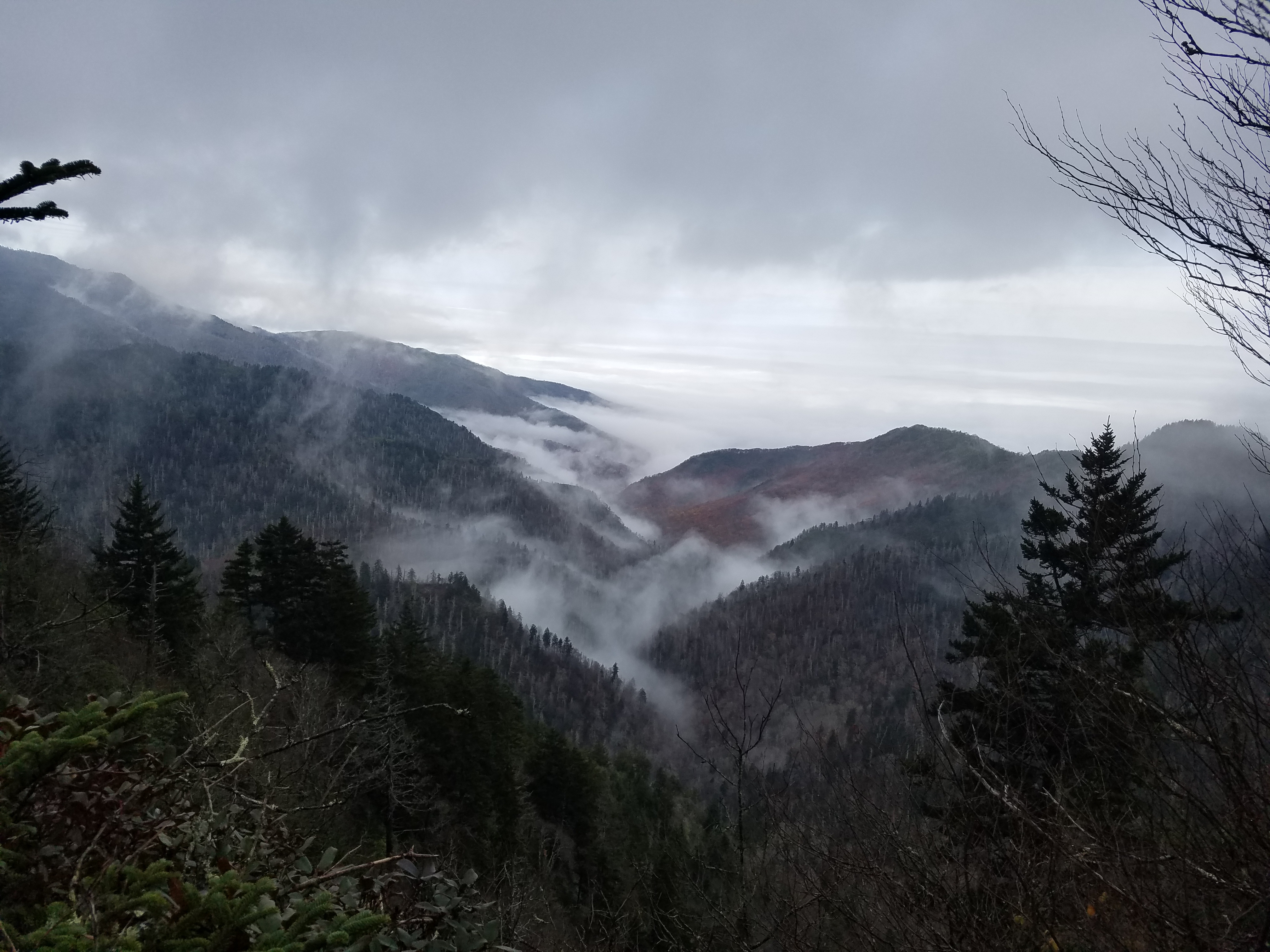
Nov. 8th Nice to see more than a few feet ahead of me.
I took about five days to complete the 70.5 miles through GSMNP. Most of those days were rainy and chilly. The first couple days it rained so much that the trail turned into a three- to five-inch deep stream and there was no way to avoid wading in the rushing water. The good thing about cooler weather was that there were no insect pests.
Double Spring Gap Shelter

Brian and Megan – Double Spring Gap Shelter
On November 8th, I arrived at Double Spring Gap Shelter (Mile 1993.4). The first thing I liked to do when getting to a shelter or campsite was to refill my water containers. When I got back to the shelter, father and daughter section hikers, Brian and Megan, were there. A short time later Steve, a solo section hiker, showed up. We spent the next hour or so getting acquainted and preparing and eating dinner.
Shelters in GSMNP had tarps over the front and this particular shelter had a fire place and some gracious person had left a supply of dry wood in the shelter. As darkness approached, I asked if anyone minded if I started a fire in the fireplace. No one minded. Steve went out and miraculously found some more wood that was a little wet, but not saturated. With the fire going and the shelter heating nicely, I was able to put my boots in front of the fire place to dry out some.
Brian and Megan each had a 500 ml Smart Water bottle filled with bourbon. They told Steve and me that it was their last day and offered to share their bourbon since they did not want to carry it out the next day. Usually I was in my sleeping bag and asleep by 8:00 p.m., but with the relaxing ambiance of the fire and the warmth of the bourbon, we stayed up until 11 o’clock, or so, enjoying a very pleasant and memorable evening.
Franklin, NC to Springer Mountain, GA
I took a zero at Gooder Grove Hostel in Franklin, NC (Mile 2080.3) on November 15th. My daughter, Katherine joined me the next day to finish the last 110 miles with me to Springer Mouintain. We got a late start and did a 7.2 mile hike to Long Branch Shelter (Mile 2087.5).
Top of Georgia
November 17th we hiked 16.3 miles to Standing Indian Shelter. The next day, we hiked another 16.7 miles to Dick’s Creek Gap (Mile 2120.5) near Hiawassee, GA. We had called Top of Georgia Hostel several times starting at 3:25 p.m. and finally getting an answer at 4:05 p.m. We were told that if we could get to U.S. 76 at Dicks Creek Gap by 5 p.m., we could get a ride into town. After keeping us on the phone for 10 minutes, explaining that we had to pay for our bunks before they could give us a ride, we had about 45 minutes to go the remaining 2.8 miles. That included downhill sections where we literally ran. We arrived at Dicks Creek Gap with about 5 minutes to spare. After waiting a half hour the van still had not shown up. Fortunately, a local trail angel stopped and gave us a ride to Top of Georgia. The van had not even left yet, so we registered and took the ride into town. The only other hiker in the van was Nicole, a new tramily (trail family) member from Germany.

On Nov. 18, Katherine and I did a slack pack northbound 16.7 miles from Unicoi Gap (Mile 2137.2) back to Dicks Creek Gap. After doing nearly 50 miles during the three previous days, including the hurried run down hill, my left leg (which I had previously twisted) was very painful. We decided to take a zero and recuperate on Nov. 19th.
Mountain Crossings
From Unicoi Gap, we only had 52.3 miles remaining. With my leg acting up, I wanted to slow down; Katherine was agreeable since she had budgeted two weeks for her vacation and we still had nine days. Over the next two days we hiked 9.7 miles to Low Gap Shelter (Mile 2146.9) and 11.5 miles to Neel Gap and Mountain Crossings Hostel (Mile 2158.4). Obiwan and Nicole were both at Mountain Crossings. We all took a zero the next day, Thanksgiving Day.

Jason – Thanksgiving Day Dinner at Mountain Crossings
Thanksgiving Day was very relaxing. We watched VCR movies during the afternoon. One of the movies was “A Knight’s Tale” with Heath Ledger. Nicole had not seen it and she seemed to really enjoy it. That afternoon, Jason (store manager) brought Thanksgiving dinner: Rotisserie chicken, spring salad, potato salad, macaroni salad, fried chicken, cole slaw, pumpkin pie, pecan pie, fresh fruit, and cookies. It was quite a feast.
We only had 31.4 miles to go after Mountain Crossings.
Help from tramily
Recognizing my limping progress, Nicole and Katherine offered to help carry some of my load. Accepting their offer reduced my pack weight to under 20 pounds which made it a lot easier for me to finish.
On November 24, we hiked 10.8 miles to Woody Gap (Mile 2169.2) where we set up our tents on a hill overlooking the parking lot. There was a lot of activity with day hikers and noisy overnight campers.
November 25th: we hiked 13.2 miles to Hawk Mountain Campsite. This was one of the nicest campsites on the entire trail, in my opinion. There are some 30 tent pads and we hiked to some pads near the newly built privy. We only had 7.1 miles left before the summit of Springer Mountain.
Last Day on the AT
We were up and back on the trail shortly after daybreak. I had mixed feelings. While looking forward to being finished, I knew I would miss the life of the trail (and I do).

Katherine, Nicole, and Red Beard – Springer Mountain, GA
We got to Big Stamp Gap, U.S. Forestry Service Road 42 shortly after 11 a.m….only one mile to get to Springer Mountain terminus. After a short wait my high school friend, Gay Reed, and her husband Steve got there. Katherine and I put our packs in their car, and with Nicole, headed out to finish the last mile.
Nicole was planning to camp south of Springer Mountain and the next day hike the approach trail to Amicalola Falls State Park where she would meet her trail angel/friend. Obiwan had arrived at Big Stamp Gap early in the morning. His son met him and hiked the last mile with him.
Gay and Steve were wonderful trail angels for Katherine and me. Not only did they meet us at Big Stamp Gap, they patiently waited an hour while we finished the last mile to Springer Mountain summit and back (2 miles round trip). Then they took us to their nearby cabin and fed us lunch and dinner and let us spend the night in the cabin. Katherine had left her truck at her friend’s (Jennifer) house south of Atlanta. Gay and Steve made the long drive to take us to Jennifer’s.
Katherine drove us to Ocala, FL where my wife picked me up for the final leg home to Lakeland.
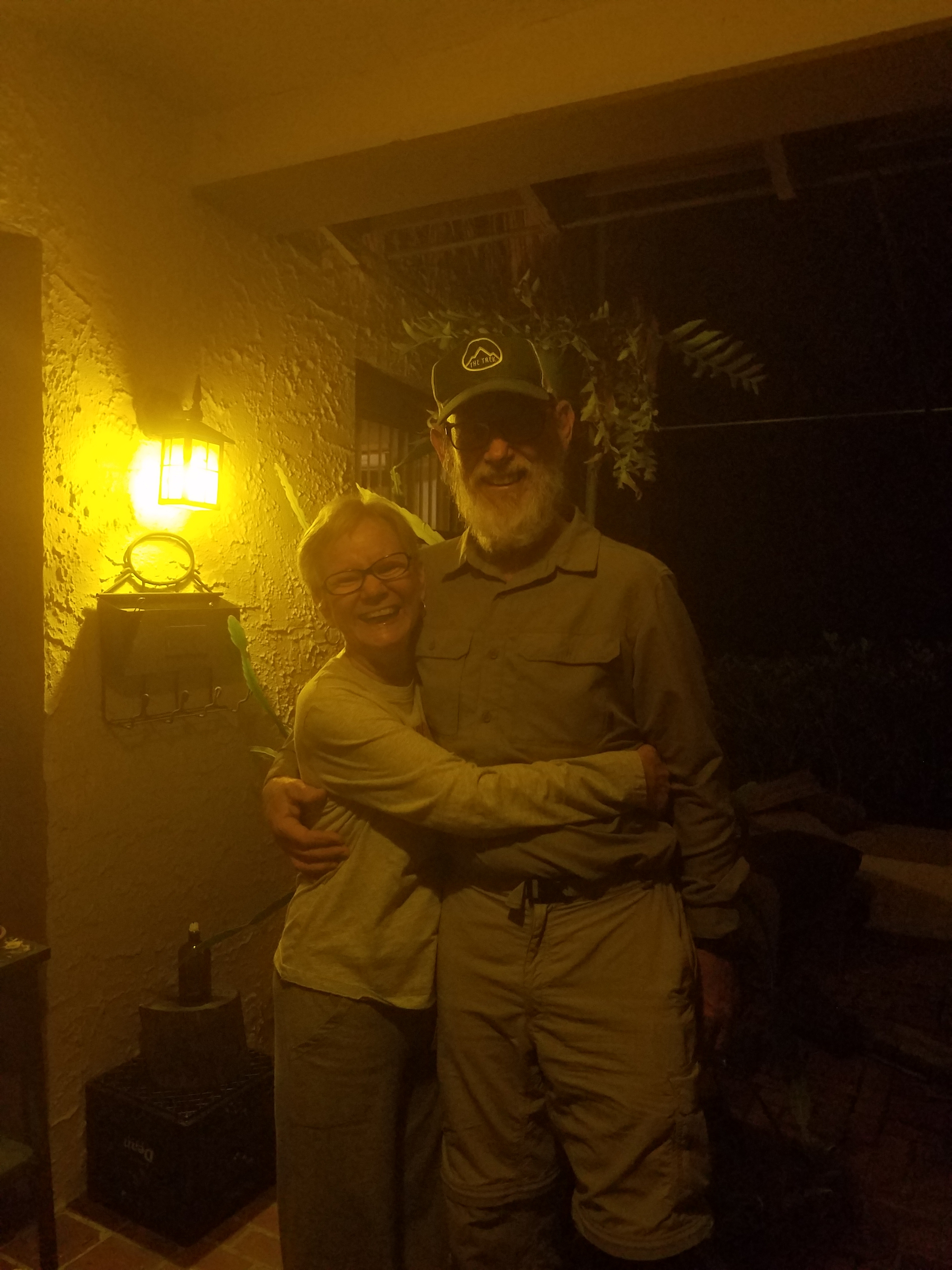
Becky and Tom Abel
Trail Names I Could Have Had
Reflecting back on my thru-hike, I was glad that I had selected my trail name, especially when I think of the trail names I could have had. Red Beard would not have been a good name if my beard was still red. People would just say, “Yeah, so what?” Since my beard is white it was a conversation starter…there must be a story behind it.
The first alternative name that comes to mind is “Limper”…the reason is obvious. Another variation based on rate of travel could have been “Pokey” or some other such term that related to my slow progress and everyone passing me. What might seem contradictory would be the name “Runs Up Hill”; however, that would be referring to my nose. I think I was allergic to going up hill because every time I was hiking up slope my nose got runny. I’m glad no one called me “Sniffles.” I gave up trying to use a handkerchief after a while and just did the farmer’s blow, which, in cruder terms, could have resulted in the trail name “Snot Bomber.” I also could have been called “Foggy” because when the weather was humid or raining, my glasses would fog up and I could barely see. When that happened, I usually took off my glasses. Another potential trail name that comes to mind is “Three or More” relating to the number of times I had to get up during the night.

This website contains affiliate links, which means The Trek may receive a percentage of any product or service you purchase using the links in the articles or advertisements. The buyer pays the same price as they would otherwise, and your purchase helps to support The Trek's ongoing goal to serve you quality backpacking advice and information. Thanks for your support!
To learn more, please visit the About This Site page.

Comments 15
Great article. Very interesting. The one thing that isn’t clear to me though is “slack pack” . Very adventurous journey!
To slack pack is to Hike with a day pack, borrowed from the hostel, with only food, water, and clothing needed for a day hike.
Nice story.
One of my first AT books and most favorite was Bare Foot Sisters Southbound. It must be a directional thing. Someday. I too will get my hike in, you have added hope. Thanks for the read, congrats.
Hi Tom,
I too have been thinking of a thru hike for a long time. I read your story and an encouraged be it. I am 53 and am not sure when I will get to it but I definitely want to. Thanks for your story.
Tim
I enjoyed hearing about your trip.I too am a senior and hope to do my thru-hike in a couple years.Did you do amlny training beforehand ?
In 2016 (and 2017 prior to leaving for Maine) I went to the gym 3 days per week for four hours and did stair climber and treadmill, leg work machines, and upper body work. Florida doesn’t have mountains, so in 2016 I went to: 1) Maine and climbed Mt. Katahdin, 2) North Carolina, Clingman’s Dome and Hump Mountain 3) Georgia – Approach Trail from Amicalola Falls State Park 5) Arizona – Grand Canyon 6) Puerto Rico – El Yunque Mountain. I also occasionally went to a mountain bike trail which was constructed in old mined lands near my home. I wore my loaded pack and hiked 10 miles or so. I have made it a goal to walk 10,000 steps per day (American Heart Association guidelines) since 2014.
It still took me 7 or 8 weeks to develop trail legs. Every day on the Appalachian Trail is training for the next day.
Loved reading your adventure.
My 2009 “thru-hike” has yet to be completed. After doing over 700 miles last year I’m down to one last state, Maine. I’m aiming at 2020 to go back.
Of all the places I’ve ever gone, things I’ve done, backpacking is #1. I’d go every year if my husband could tolerate my absence that often.
Congratulations on finishing.
Happy Trails 😉
You saved the best for last (Maine). Happy trails to you too.
Great writing; really enjoyed the read. DMFINO
Great thoughts! Plan on doing the NOSO in May 2019. I too am 67. Can’t wait after reading your story.
Good luck on your hike. Let me know if you start a blog. I would like to follow.
Fantastic thoughts, both entertaining and insightful. I think we crossed paths in the vicinity of Lee, Massachusetts or Upper Goose in early August. Thank you and congratulations!
Hi Otter. I stayed at Berkshire Lakeside Lodge on 6 Aug. Old Timer stayed at Upper Goose Pond and I think he helped with the pancakes the next morning. I hiked from U.S. Hwy. 20 to Mount Wilcox South Shelter on 7 Aug without stopping at Upper Goose Pond. I saw your blog on Postholder. Are you planning to hike this year?
great info! thanks for sharing
One questions I had, what kind of eggs did you use to make breakfast in the mornings?
Asking for my husband who LOVES eggs and habitually has them every morning
I like Mountain House freeze dried eggs. Not everyone does.