 ">
">
Springer and I’m Done until Spring
This blog post was without question the hardest to write. This is the first one I’ve written in a couple of months where I didn’t have my imminent return to the trail looming to keep me focused. The impact of my journey’s end this year has me stunned. I feel like I have almost too much to say. In the end I decided to split it in two. This one is simply the nuts and bolts of my last ten days on the trail; the next will deal more with the impact of walking 1,022 miles of the trail this year and living in the woods for three and a half months. My shoulder injury kept me from finishing my thru hike, but my time in the woods changed me forever. Zach’s book, Appalachian Trials, suggests that you think about how your life will be different after you finish the trail. Knowing why you are taking on the burden and what is really in it for you, enhances your chances of success. Thru hiking is a tough thing to do and you will have to do battle with some demons along your way. You best have some answers to hold them at bay. While I’ve only finished half the trail, I’m ready to testify that my pre-hike speculations about the blessings the trail would bestow on me fell well short of the mark. But then you don’t really need to understand the full impact of your journey to help you through the rough patches, you just need something you can hold onto. Hope I can capture it all!
I got a shuttle to take me back to the trail after two nights in Franklin. They dropped me off at Winding Stair Gap. Later that afternoon I found that the trail north of there was closed that day because of a fire. I walked south to Albert Mountain and camped on the summit near the fire tower. The sunset was gorgeous! That night, I “watched” game seven of the World Series on my phone. This really means I stared at the live box score on the ESPN ap for hours and ended up burning through all the power stored in my largest battery. I would have to go into Hiawasee, but it was worth it. These two teams have each played longer than any other team in their respective leagues without a championship. One was going finally get one; the other, another story to tell.

The sunset from the top of Mt Albert.
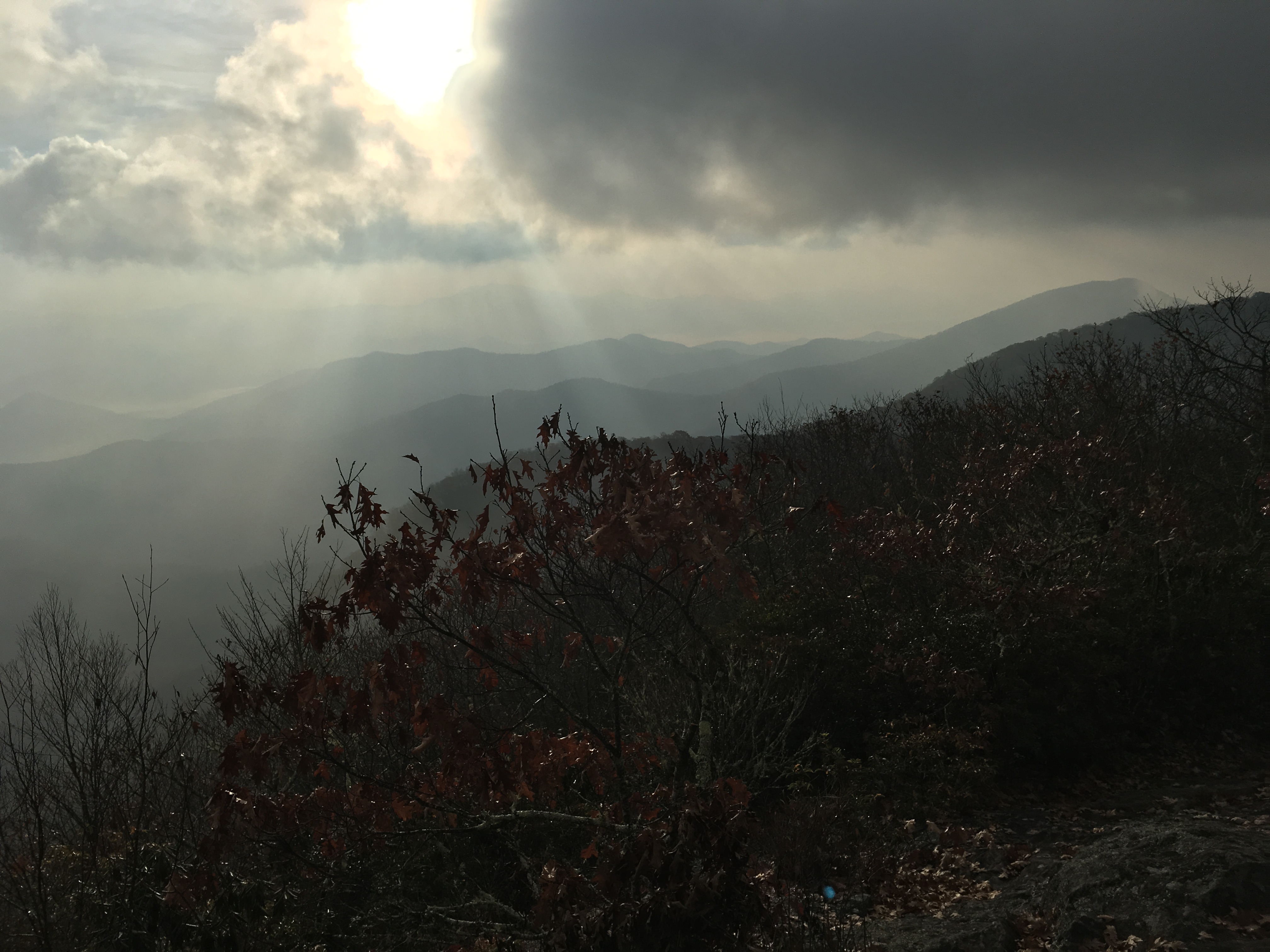
And the sunrise the next morning
The next morning, I continued to the south and spent the next night on Standing Indian Mountain where I again camped near the summit. Again I was treated to an amazing sunset. I realized I was looking back toward the Smokies. I posted a shot on Instagram and one of my followers pointed out that all the fires were making the colors more vivid. The next morning I could see the smoke from the fire. It’s upsetting that the beautiful country I walked through to get Franklin was burning. At this point, most of the leaves have fallen. Everywhere leaves cover the ground. The period from October 15th to November 15th was the driest in the last 65 years. One cinder blowing in the wind landing in a new new spot and you have a new fire to deal with. Imagine trying to control a fire in a place this! I thought of the woman who picked me up and gave me a ride into Franklin. Her planned hike was pretty much wiped out by the fires. Hope she was able to change her plans. I was lucky. Dodged another bullet.

Morning vistas just south of Mt. Albert

Sunset from Standing Indian Mountain made all the more intense by the fires burning to the north and west
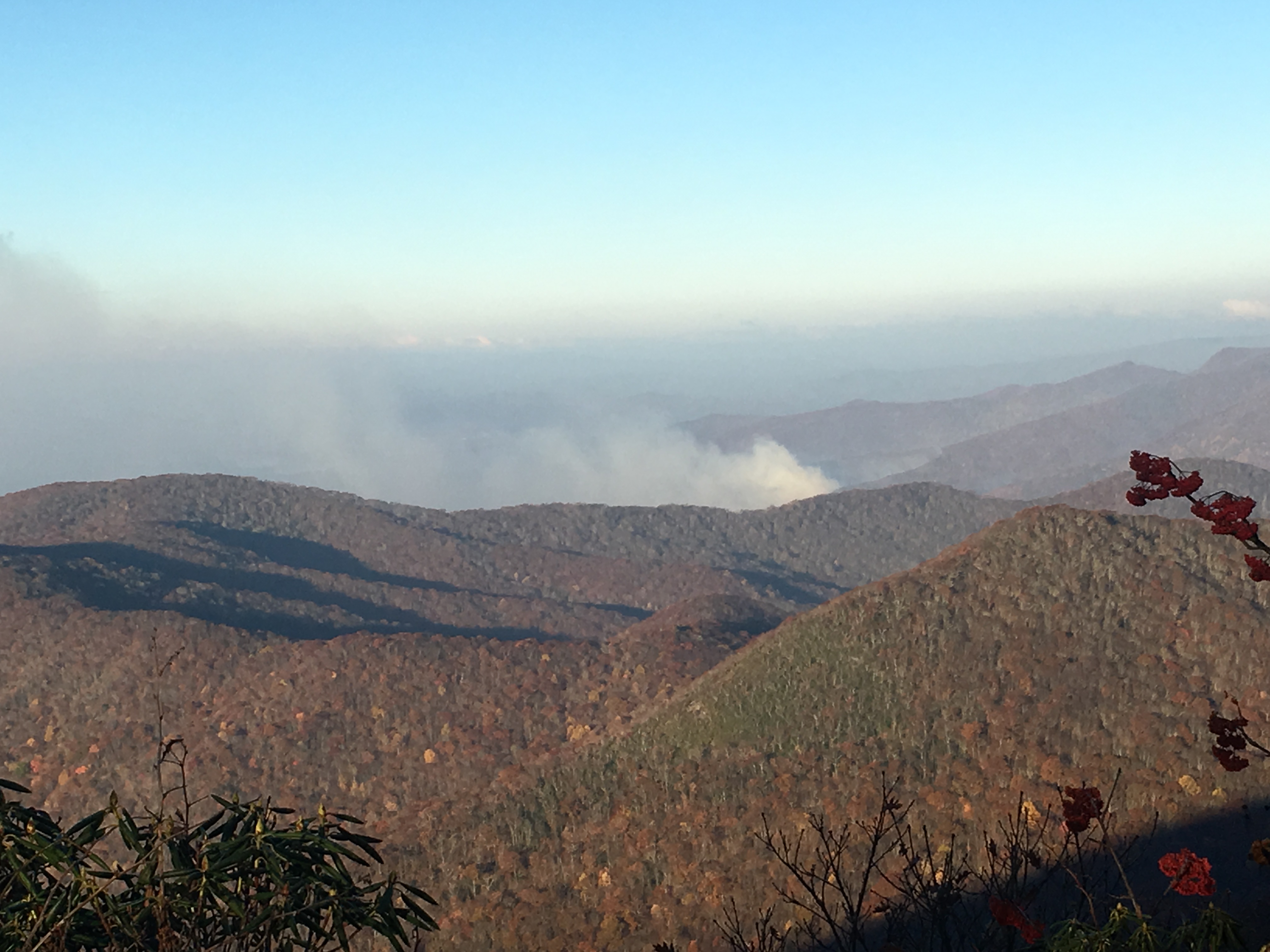
The next morning from Standing Indian Mountain smoke from those fires was clearly visible
The next day I crossed into Georgia. While it felt good to finally make to Georgia, it was as if a switch flipped in my head. For 400 miles, I’d been listening to my body and walking what it said I could do. Now I’m trying to get Springer by Friday. A lot has happened at home while I was on the trail. For one my wife took a job in Maine and my daughter and her husband had to step up and watch our dogs along with their own and their two old son. That seemed like a lot to ask of them. So I pushed it a bit and started each day with a destination in mind. Hiking became more like work. I don’t think I liked this new paradigm. All miles are not created equal. I never really knew how long it would take me to walk to a particular destination until I had actually walked it. When I aimed for a set destination, I often ended up having to hike after dark or dealing with the emotional consequences of not achieving my goal. I felt better just saying, “I’m walking until 5:30 today.” Time I can control; daily mileage is more a function of the trail and how it interacts with this effort.

It was good to be able to cross another state off the list!
The day after I crossed the Georgia border, I stopped at the Plumorchard shelter for lunch before heading into Hiawassee to recharge. (Was I the only one disappointed that there seemed to be a total lack of plum ladened trees there?) Tom, last seen at the Overmountain shelter caught up with me as I ate lunch. I was shocked to find him behind me, but he had spent more time in towns along the way that I had. I met a couple of flip-floppers, Chicken Feet and Disco there too. All three had met my trail sister, Dysfengshuianal in the Smokies. Chicken Feet and Disco had met Otis who I had hiked with in the spring for a few days. Otis was the only hiker that I saw every week in my spring, pre-surgery LASH. Otis was an odd duck who had a unique approach to life on the trail. I ran into an insane number of thru hikers with Otis stories. Chicken Feet told a story of watching Otis cram an insane number of cookie packages into his food bag with a pint of vodka. Those cookies were 250 calories a package whether they were reduced to crumbs or not. Otis always carried a 5 pound bag of sugar. When he got to an uphill section, he’d put a quarter cup of sugar and a quarter cup of instant coffee in a bottle and chug it. Otis knows his energy drinks. The guy is legend.
Hiawassee proved to be a fun little trail town. I ate well, did some laundry and recharged my batteries. After breakfast I took a shuttle back to the trail. The shuttle driver raved about the Boundary Waters. I will confess that they are on my bucket list. Later she called and left a message about another fire south of me. I took an easy day. My son was running the NYC marathon and I stopped often to check on how he was doing. He was trying to qualify for Boston. While he fell short of that goal, his 3:27 time was respectable. In spite of my lazy approach, I still managed to get in 11 miles before dark. I met a pretty significant bubble of SOBOs. I told them about the new fire. We all stopped at Tray Mountain. After getting water from a fairly sketchy puddle, they pressed on. I set up my tent near the shelter. The next morning, I was treated to a fabulous view. I set up in the dark and had no idea it was there. I was able to visit the ATC’s webpage to check on the new fire. Only 0.9 of a mile of trail was closed from Hogpen Gap to Tesnatee Gap. The site said that there was no active fire on the trail at present and they were hoping to reopen the next day if the situation improved. I decided to walk to Hogpen Gap and explore my options. It was going to take me a couple days to get there. As I walked south, I met a couple of NOBO section hikers who told me the trail was open and that they got through without any problems. When I could get online, the ATC’s site wasn’t giving any additional information. When I got Hogpen, there was pink plastic tape with fire written in black marker by hand. It didn’t look very official and as it was close to 5:00 pm and no one was around to help me get out of there. The site had suggested that the closure might be lifted after 24 hours and the hikers I had met that day coming the other way assured me that there were no problems. With no cell service at Hogpen Gap, I wasn’t able to get any updates. Thinking if there was an active fire in the area there would be someone there to fight it, I decided to sprint the 0.9 miles to Tesnatee Gap and start looking for a place to camp. This was probably not the best move, but at the time it seemed to be the best option available. It is incredibly hard to step away from a goal you’ve worked toward for almost two months without any reliable information. I ended up cowboy camping near an outlook on Cowrock Mountain. This was election night. In spite of the altitude, I had almost no signal. About 1:00 am, the smell of smoke in the air work me up and I was able to read a couple of tweets that hinted at Trump’s victory. I walked on in a daze contemplating the end of civilization as we know it. I came to the conclusion that half of us were going to feel this way no mater who won. We deserved better. (I did vote absentee before leaving in September!)
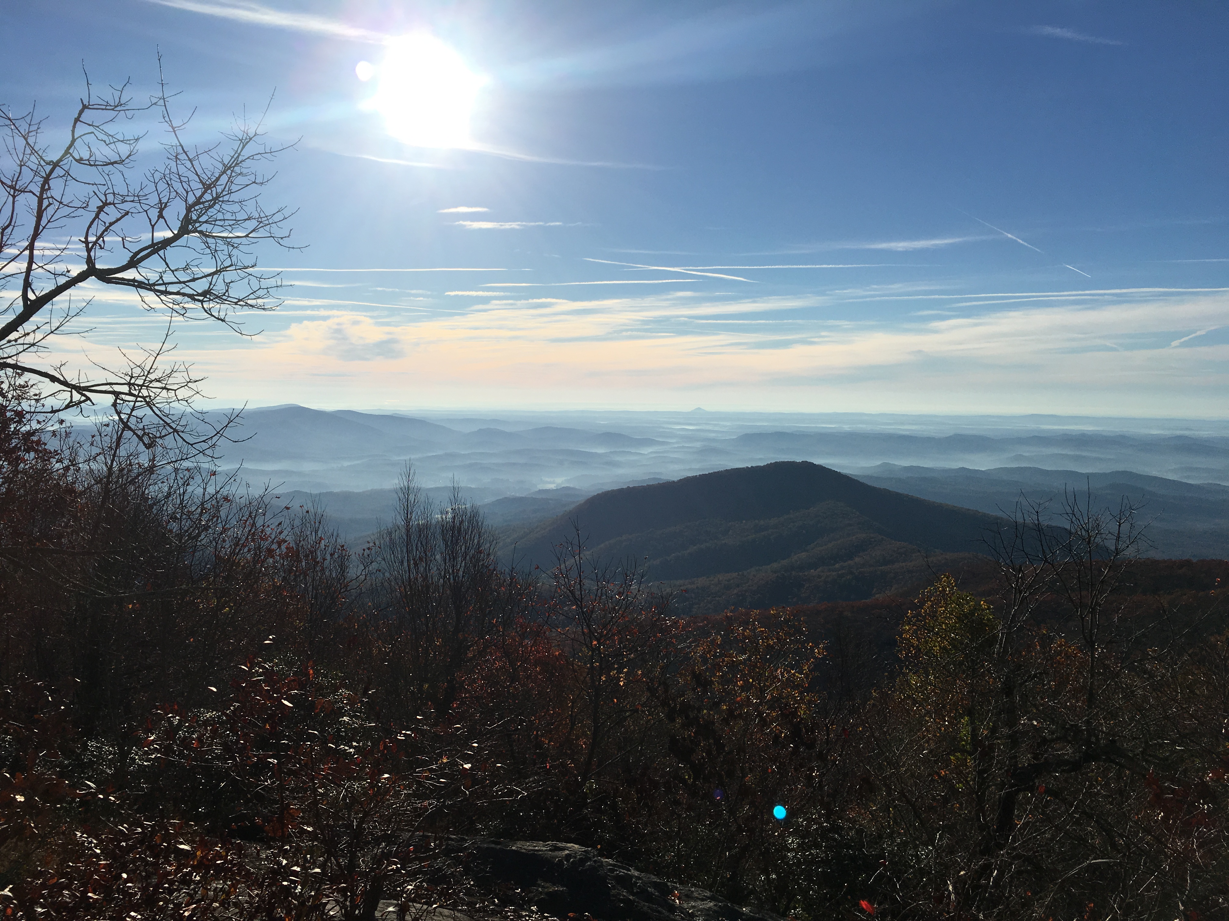
The view from my tent site near the Tray Mountain Shelter

A lot of the beauty you see on the trail springs from majestic views that reveal our insignificance in their grandeur. Here a close up shot of an open seed pod next to trail. Such small b beauty can be just as breathtaking.
I got to Neals Gap in the early afternoon. I picked up some cinnamon rolls, tuna and a couple of Cliff bars, ate a couple of microwaved cheese burgers and ice cream sandwiches and washed it all down with a couple of bottles of gatorade. Hiker hunger is real. The outfitter at Neals Gap was crawling with SOBOs giddy with thoughts of finishing. Tom was there too, catching up with me after a zero in Hiawassee. I called a shuttle to pick me up at Springer on Saturday. I flirted with just going home, but I was too close to actually pull the trigger on that idea. I crawled up Blood Mountain and hiked until about an hour after dark. Not my favorite thing to do, but if I was to make it home by Sunday, I had to do it. Long division was a cruel taskmaster. To get to Springer on Friday, I had to get in the miles and this meant hiking after dark. As I approached Springer on Friday afternoon, the trail changed. It morphed into a backwoods super highway with multiple lanes and a startling lack of trip hazards. Actually getting to Springer was almost anticlimactic. Over the last two months, I had summited scads of peaks who offered a more epic payoffs than Springer. Emotionally getting to Springer was confusing. Sure this marked my journey’s end…I had made it, but I had also reached an level of comfort and acceptance with life on the trail that I wasn’t sure I was ready to give up.
Getting back to Greensboro from Springer was an adventure. The shuttle to Gainesville, Georgia costs twice as much as the guidebook’s suggested. Greyhound buses to Greensboro took over 24 hours to get there (I’d rather get my wisdom teeth pulled!); the train pulled into Greensboro at about 4:00 AM, but left at about 9:00 PM well after checkout time at my motel. I ended up walking to a movie theater and watched movies all afternoon before taking the train home.

Hiker trash at Neals Gap getting ready for the final push to Springer

Views from just south of Blood Mountain near Neals Gap. The trail was beautiful even after the end of civilization as we know it and hell freezing over
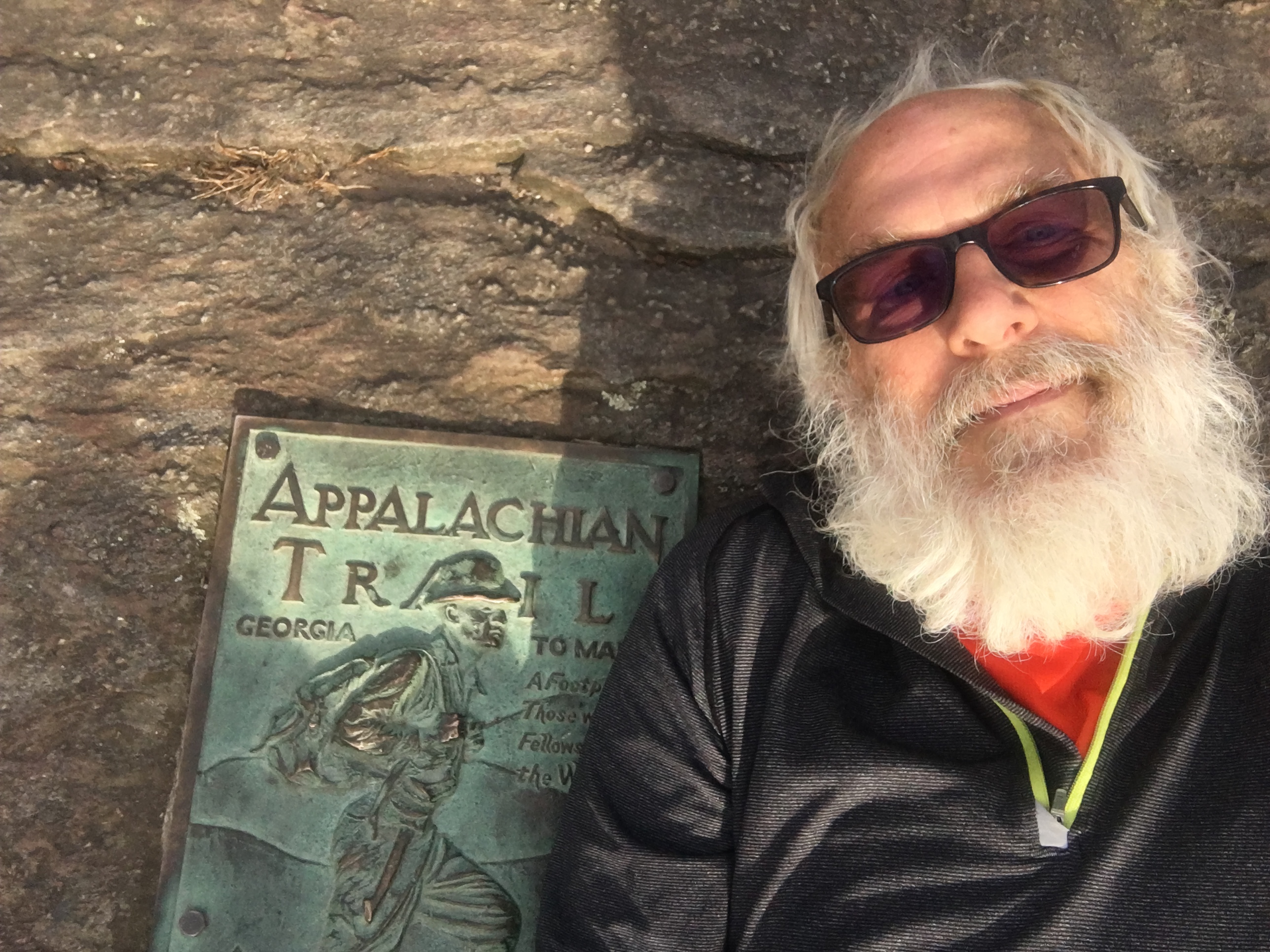
Springer at last
Next spring (Mid-April to early May), I will leave Harpers Ferry to hike north. Baring another in jury, I will summit Katahdin in July. Can’t wait!

This website contains affiliate links, which means The Trek may receive a percentage of any product or service you purchase using the links in the articles or advertisements. The buyer pays the same price as they would otherwise, and your purchase helps to support The Trek's ongoing goal to serve you quality backpacking advice and information. Thanks for your support!
To learn more, please visit the About This Site page.

Comments 2
Everybody this year has Otis stories. We are all lucky to have met that guy. 🙂
A hiker trash legend!