 ">
">
Steph’s AT Hike, Days 21-25: Near Fontana Dam to Bluff Mtn
Day 21
Near Walker Gap to Fontana Village
5.2 miles
Due to my big mileage the day before, today was a shorter hiking day for me. The AT in this section was almost exclusively downhill, so I lingered on the way down and was rewarded with a snake sighting plus very interesting rocky outcrops during the morning’s walk.

Hello, Mr. Snake.
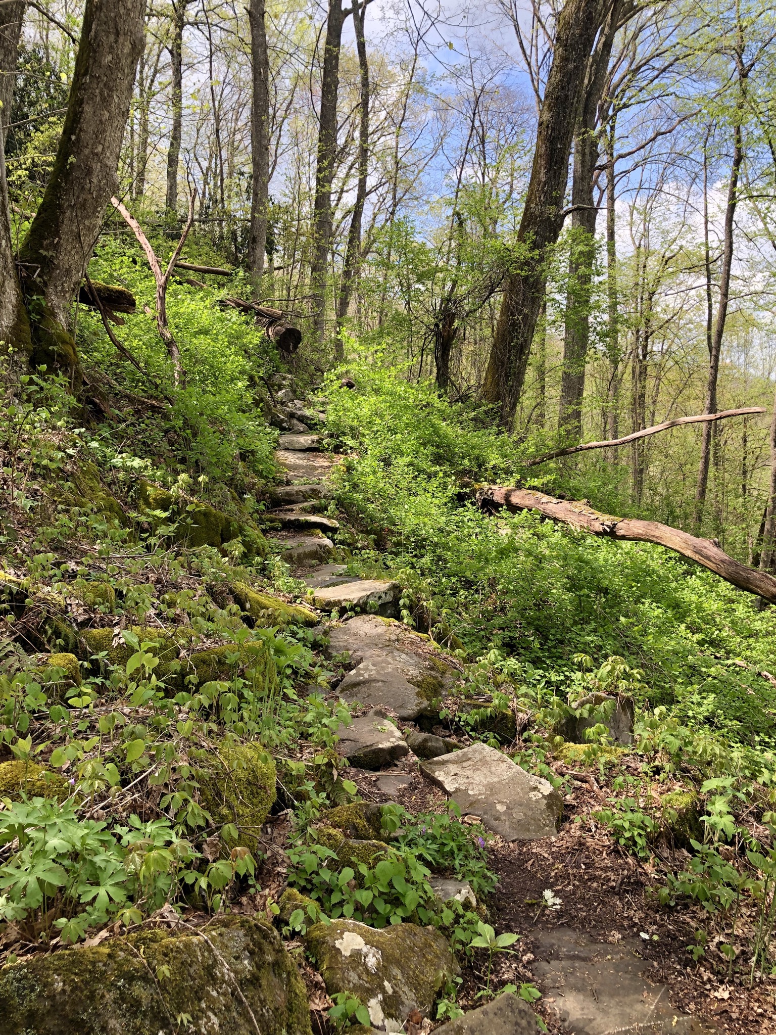
The trail here was completely paved with large, mostly flat stones.

I arrived at the Fontana Village resort just in time to snag a bite to eat at the main restaurant, do a quick load of laundry, and grab a few beverages to take to the nearby shelter.
The shelter here is one of the largest and most nicely maintained along the whole of the AT. It sleeps 24 hikers, has picnic tables, a huge fire pit with benches, potable water from a spigot, trash cans, and flush toilets. No nasty privy here! And – this is the best part – showers! It’s easy to see why this shelter has been dubbed the “Fontana Hilton”.
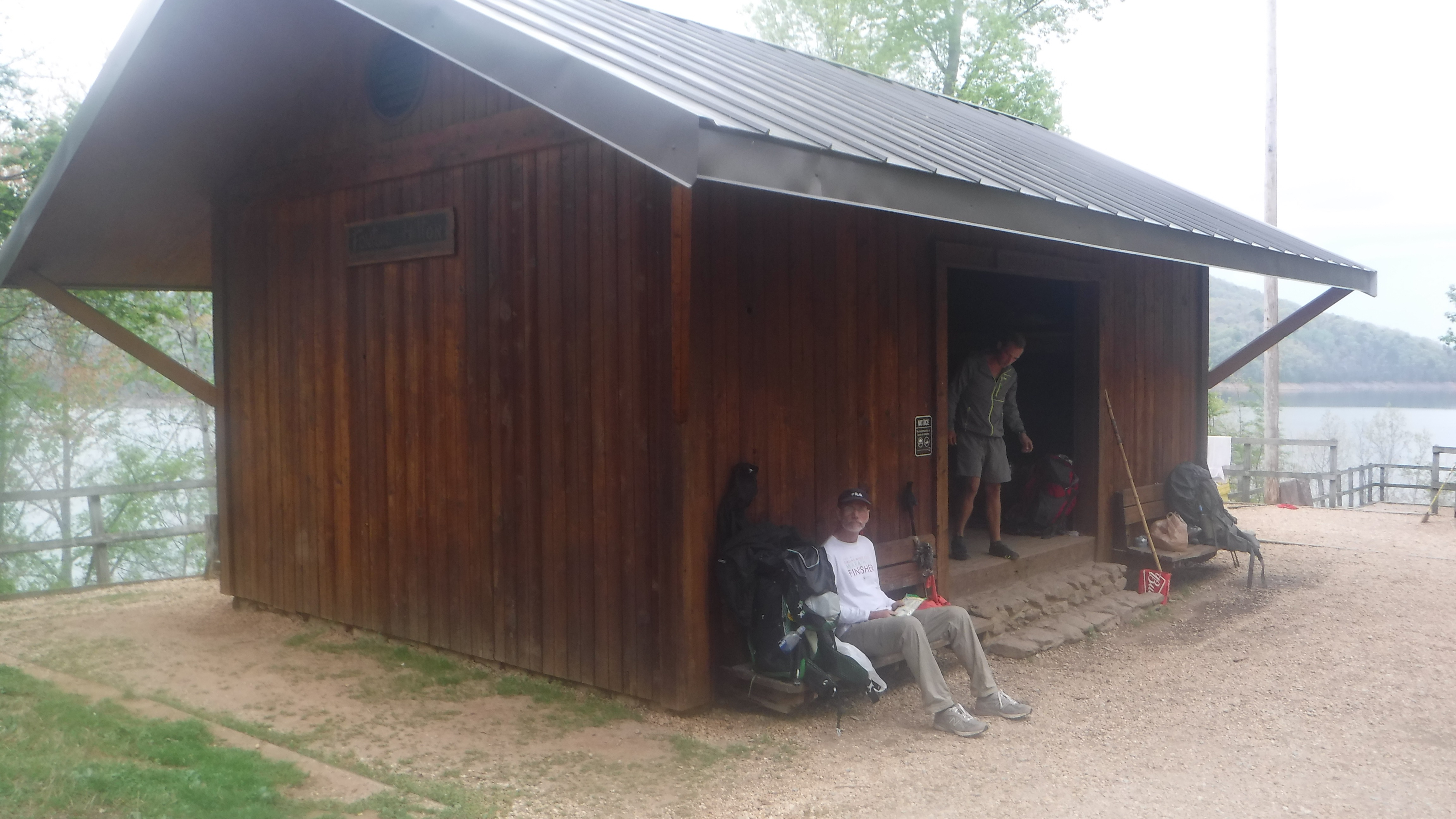
The Fontana Hilton, one of the largest shelters on the AT. 22 hikers slept inside the night I was here.
Unfortunately the local mice are as fond of the the Fontana Hilton as the hikers are. All night long I could hear mice running around the shelter, scurrying around the people lined up in their sleeping bags like sardines in a can. I was extra careful to remove anything from my pack that might be enticing to a mouse, but others who were not so thorough found bags and items chewed through and ruined.
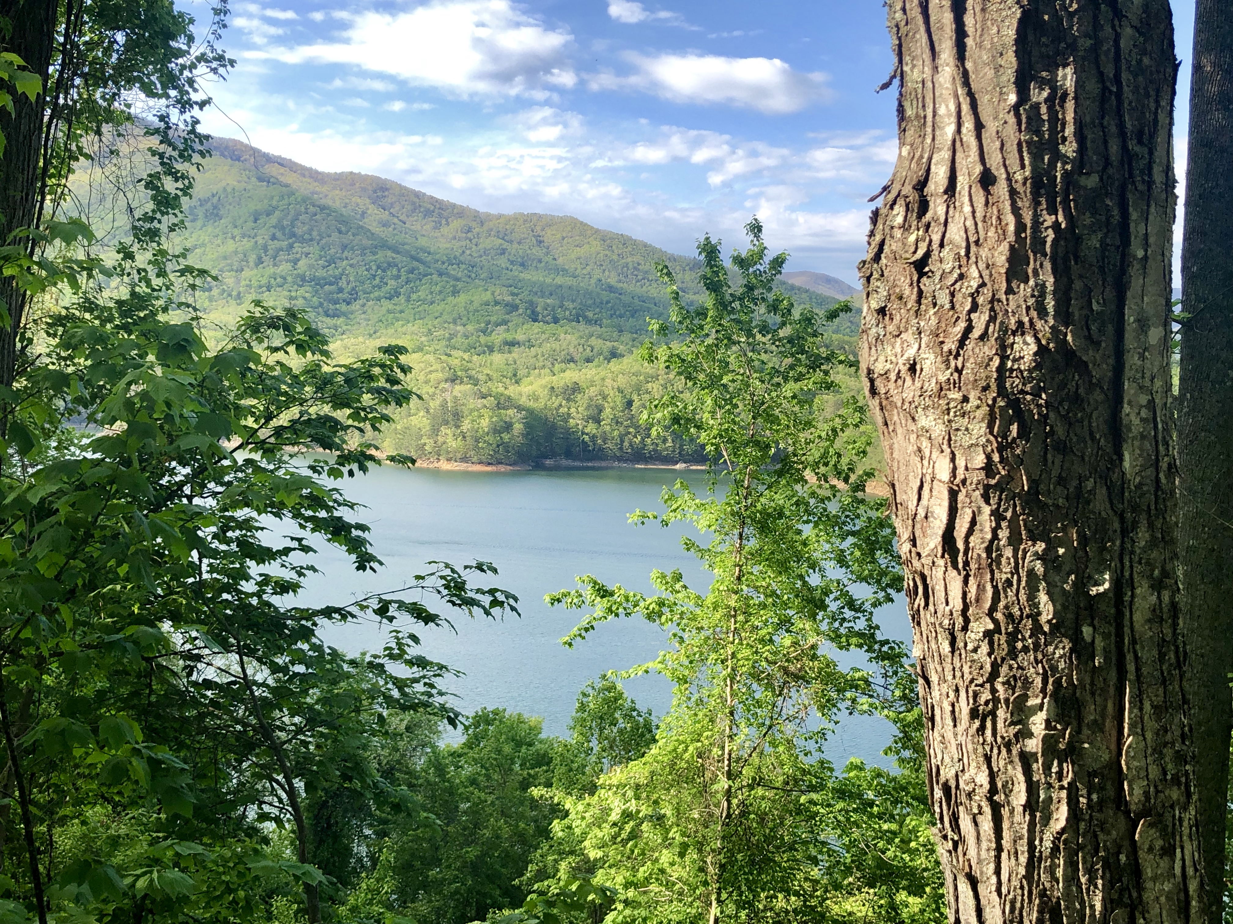
View of Fontana Lake from the Fontana Hilton shelter area.
There were some great views of Fontana Lake from the shelter. Just down the road is Fontana Dam, the tallest dam east of the Rockies. It was completed in 1945 by the Tennessee Valley Authority and stands at 408 feet tall. It’s here that AT hikers walk the road atop the dam to enter into the Great Smoky Mountains National Park.

Fontana Dam
Day 22
Fontana shelter to the marina, then shuttle from Fontana to Davenport Gap
1.4 miles
Today was a “nearo” day, meaning my mileage was nearly zero. I was picked up by Steve “Mustard Seed” Claxton around lunchtime today and shuttled to Davenport Gap. He was a little late to pick me up, but more than made up for it in great conversation and a free lunch 🙂
I knew my brother was on his way to meet me and coming from Illinois, so we decided to get bunks just off the trail at Standing Bear Hostel for the night and begin hiking the next morning. The hostel was rugged but my linens were clean and having a bed to sleep in was so comfy! The other hostel guests were also hikers, and very friendly people who welcomed newcomers around the communal campfire.

Sign that welcomes hikers to the rustic Standing Bear Hostel.

Bunkhouse at Standing Bear.
My brother arrived later in the evening, and we stayed in one of the semi-private cabins that slept a total of four people plus one German Shepherd dog named Camo. The shared cabin we bunked in was built directly over a creek, providing an ambient noise that I found incredibly soothing.

Stream that runs under the cabin I slept in.
Day 23
Standing Bear Hostel to Groundhog Creek shelter
7.7 miles
After a final post-breakfast gear check, my brother and I set off from the hostel and hiked back to the AT trailhead just down the road. Unfortunately for him, the first four miles of trail were a steep climb from the gap up to Snowbird Peak, gaining 2500’ in elevation over a short length of the AT.

Morning break, before it got too tiring and we were no longer quite as smiley.
We moved at a pretty good pace at first, but it soon became apparent that his lungs were definitely not yet adjusted to the elevation difference in these mountains versus the flatlands of Illinois. So we slowed it down a bit, trying to enjoy the trail itself instead of just powering up the hills as fast as possible. So many more wildflowers were in bloom, and I couldn’t resist snapping pics of as many different ones as possible.

Wildflowers of the North Carolina Appalachian Trail

More wildflowers – I just couldn’t get enough of the flowers along the AT.
Lunch was eaten atop Snowbird, where we got our first more open views of the surrounding peaks. Snowbird is a “bald” mountain, meaning the summit is covered in grass and small shrubs rather than trees. This is in contrast to the majority of mountains that I’ve hiked across, which tend to be thickly wooded with viewless summits.

My brother on the final push to the top of the bald.
The view from Snowbird Mountain, looking east.
The rest of the afternoon we hiked downhill towards Groundhog Creek, where we camped near the shelter. We found a flat, smooth spot that was far enough away from the shelter that we wouldn’t be bothered much by mice, and it was right along the trail to the creek. It wasn’t until after I’d set up the tent and taken everything out of my pack that I realized we had a direct line of sight to the inside of the privy from our site as well. Let’s just say this campsite didn’t provide my favorite views – but it did make for a few good laughs 🙂
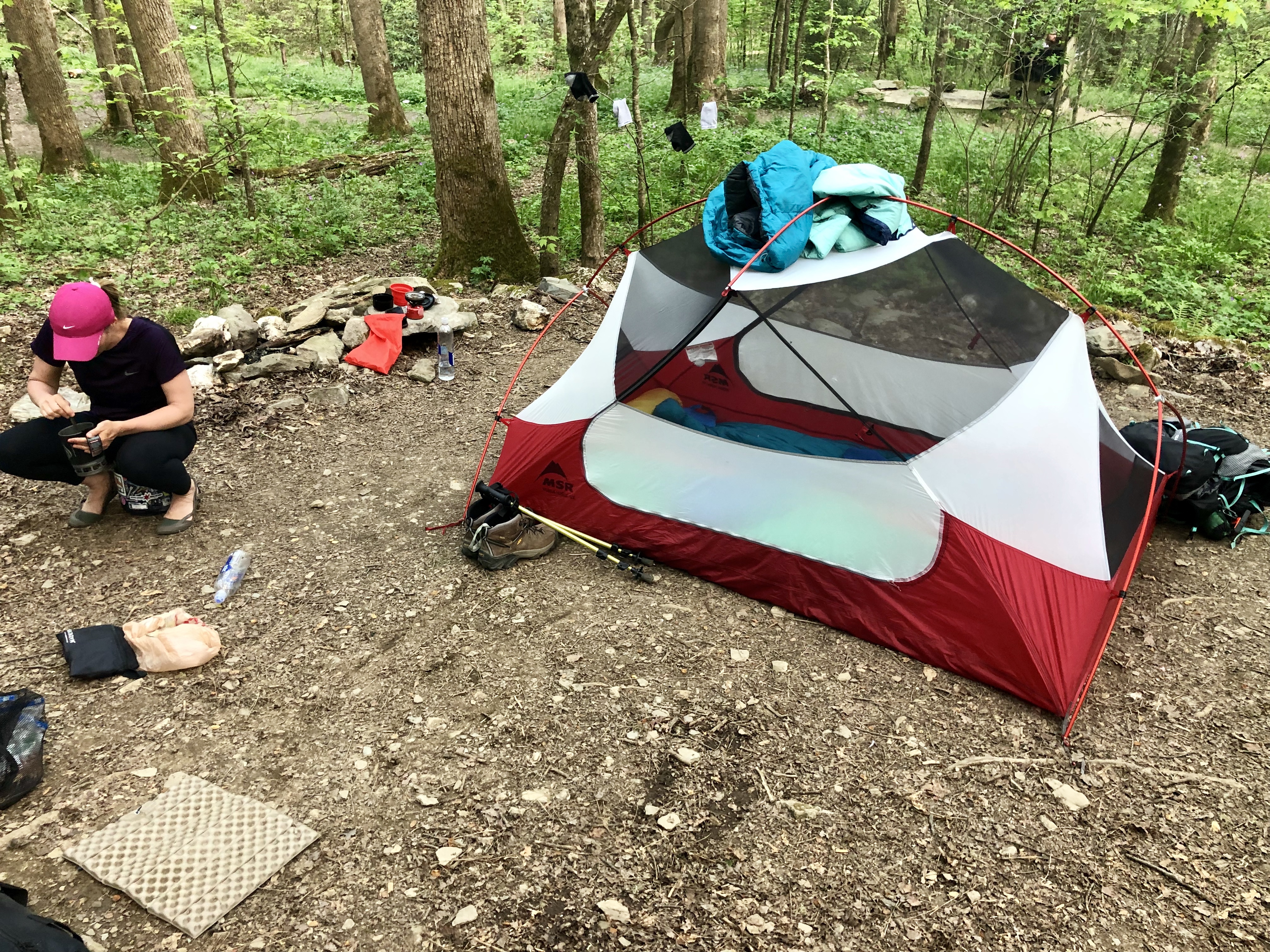
Camping spot near Groundhog Creek shelter, complete with privy view!
My brother was certainly tired out at the end of the day, but he hiked faster than I expected for someone without “trail legs” yet. Tomorrow will be less steep, so I’ve told him it will be a more enjoyable hike and less like an all-day intense workout.
Day 24
Groundhog Creek Shelter to Max Patch
6.9 miles
It was much warmer today, definitely the warmest day I’ve had on the AT so far. Usually it’s been a little chilly when waking up in the mornings but today I didn’t even take extra time snuggling in my sleeping bag when I woke up. We took our time breaking down camp, leisurely enjoying our coffee before heading out.
After a few hours of hiking, we decided to take a break and sit down for a snack at Lemon Gap. When we arrived there we found the few remaining items of trail magic left behind, so I snagged myself a can koozie emblazoned with an AT logo. Score!

Something’s missing here…anyone want to deliver a cold beverage ASAP?!
I also ran into several other hikers that I’d previously seen on the trail early on during my first week of hiking, and it was enjoyable to catch up and hear how their own hikes have been going. Since these are hikers putting up far more daily miles than me, I won’t likely cross paths with them again anytime soon.
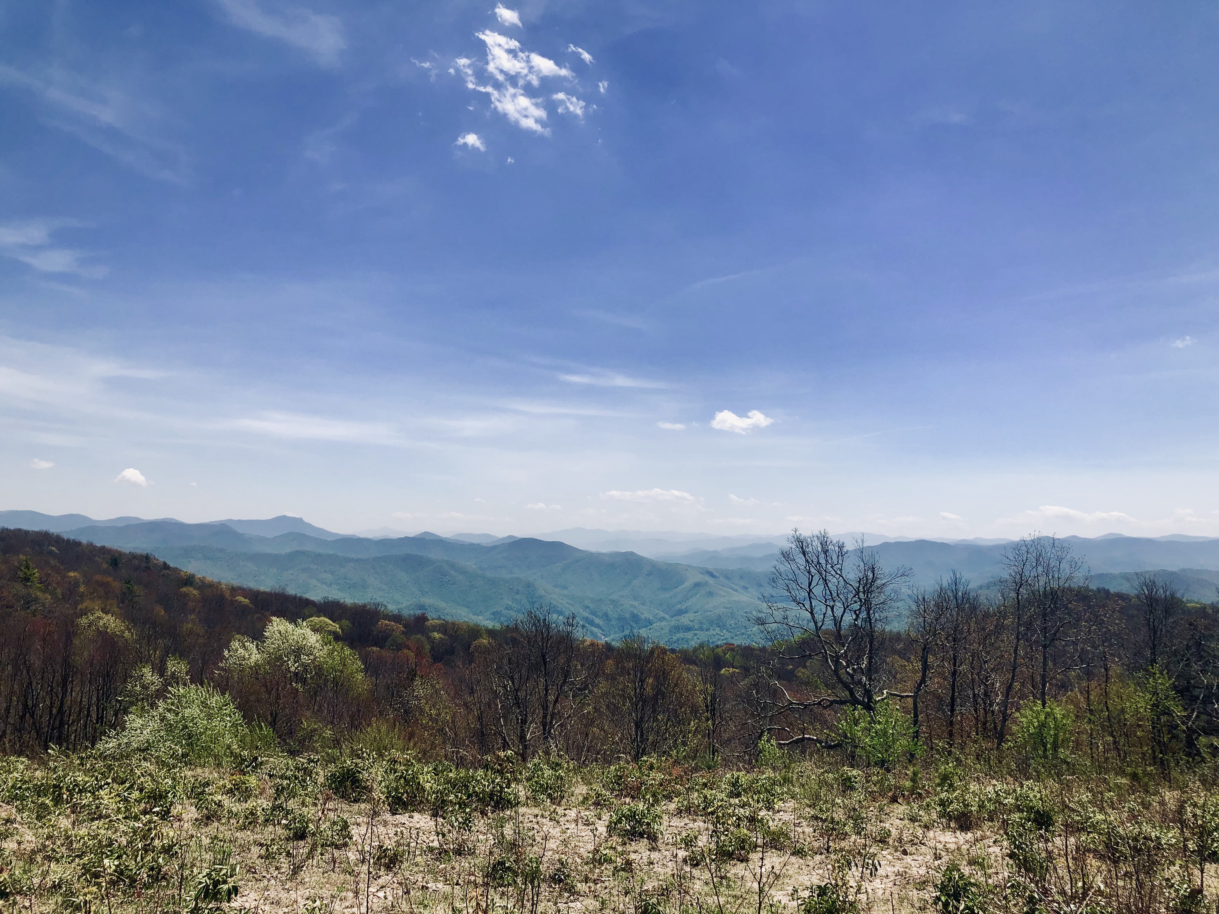
We had a very good hiking day, and the best was saved for last. In the late afternoon we ascended to the summit of Max Patch, a mountain topped with a grassy bald and standing at 4615’ elevation.

A warm sunny day and gorgeous views from Max Patch.
With wide open 360 degree views, this was my favorite summit so far. Other AT hikers as well as day hikers sat at the top of Max Patch, soaking up the sunny views of the mountain ridges surrounding us.

Another pleasing view from Max Patch.

I may have pushed him a little too hard on the uphill climbs. LOL ?
With clear skies and warmer temps predicted overnight, my brother and I moved down off the summit just a little ways to cook and eat our dinners while watching the sunset. We set up our sleeping pads and bags directly on the grass, and are awaiting the stars to come out and shine down on us. I love cowboy camping! Side note: the tent is set up just behind us, because I wanted it ready to go just in case of a pop up shower during the night.
Day 25
Max Patch to Phil’s Gap, 0.2 miles below the summit of Bluff Mountain
8.9 miles
Camping out on Max Patch overnight was an excellent call! In addition to a beautiful sunset last evening, we were treated to an amazing sunrise this morning.

It pays to wake up early sometimes.
Today’s hike led us down from Max Patch and into a fairly level section of the AT that skirted a stream for several miles, crossing back and forth multiple times. The trail was a gradual downhill with many wider portions so I nicknamed this part Le Boulevard.

Collecting water from a nice little stream.

A wide, level section of trail makes for a happy hiker.
We saw a bit more wildlife today, including wild turkey, several deer, mega snails, and a plethora of unfamiliar (to me) songbirds. As I was walking along in the early afternoon, a small grayish-blue bird startled me by flying directly out of the embankment on my left side. It seemed odd that a bird would be nesting on such a steep incline, and technically on/in the ground. However, a closer look revealed a small cavity in the side of the hill and inside were four eggs. Colored a pale blue and speckled with brown, they were so very small in size!

Close up of the eggs from an unknown species of bird. You can see that the nest was crafted directly out of the hillside.

Any Spongebob fans out there? I think I found Gary.

So many mushrooms!
We finished our day by making camp at Phil’s Gap, just below the summit of Bluff Mountain. Having spent three days now hiking at some elevation, my brother has acclimated and I’ve deemed him ready to tackle some big miles. We’ve only got another day of hiking before he has to head back home though, which isn’t nearly long enough. It’s been many years since we’ve had an adventure like this together, but it has been such a great time that I hope we get to do something like this again sometime soon. He’s a great hiking partner who understands my call to the trail life.

Sidewalk marker for the Appalachian Trail. #hiker4life
It’s now been a month on the trail for me, and I am missing my husband and kids and pup and family and friends and…well, so many things! Since I have the opportunity to hitch a free ride back to Illinois with my little bro in a few days, I’m taking a week off the trail and heading home to visit and relax. When I get back on I hope to have my oldest son hiking with me for a week or so (and maybe his girlfriend, too – the more the merrier!).
Until next time, happy trails to all ?
— Steph D “Smiley”

A friendly reminder… Always follow Leave No Trace principles while on the trail.

This website contains affiliate links, which means The Trek may receive a percentage of any product or service you purchase using the links in the articles or advertisements. The buyer pays the same price as they would otherwise, and your purchase helps to support The Trek's ongoing goal to serve you quality backpacking advice and information. Thanks for your support!
To learn more, please visit the About This Site page.

Comments 3
I really enjoy your weekly blogs. Thank you. How is this trail marked when you are away from the access points? In my previous hiking days (early 70’s) we followed orange diamonds nailed to trees or fence posts. In the North Woods we even followed blazes on trees. Made me cringe even then to see a tree scalped like that. The AT probably has rules against that.
Hi Duane, I am glad you are enjoying the blog posts!
The entirety of the Appalachian Trail(AT) is blazed, both northbound (NOBO) and southbound (SOBO). The AT uses white blazes that are painted on mostly trees, but I have also seen blazes painted on rocks, fence posts, and other objects along the trail. It has been very easy to follow so far, and would be okay even for those with little to no route-finding experience.
🙂
Steph,
Thanks for the info. Paint is fine with me. The blazing I saw long ago was done by axing off about 6 x 24 inches of bark so the white wood was exposed. Not good for the tree. We were canoeing and were grateful because we could see it from far away on a rainy day. The blaze marked the portage trail.
Hope you are safely back on the trail. Looking forward to more posts. The pictures are fantastic.