 ">
">
Summit Day
It’s 3am. Jack and I have the shelter to ourselves, where we’re both fully wrapped in our sleeping bags. I feel my phone vibrate, and as my alarm starts playing, I open my eyes to see the nearly full moon glowing in the forest around us.
Any other day, I would hit snooze. I would feel Maine’s cold October air on my nose, and burrow deeper into my bed. But today is summit day. After 154 days on trail, I’m about to finish this thing.
From my pack, I pull out a PB&J english muffin that I pre-made the night before. I eat it laying down. The sandwich is cold and dry, but who cares. I deflate my small camp pillow and gather my belongings around me, stalling, not wanting to leave the warmth inside my sleeping bag.
But time is ticking. We need to reach Katahdin Stream Campground, the base of Katahdin Mountain, before 9am, and it’s some 10 miles away. I pack everything up, and then hobble on sore feet and stiff legs to the privy.
Over the past 2 days, we’ve hiked over 50 miles. This wasn’t our original plan; rather, a last minute push we made based on weather. While today’s mountain forecast doesn’t look ideal, it’s expected to be much better than the following day (our original summit plan).
Now, with bags packed, and headlamps on, Jack and I say goodbye to our last shelter on the trail. I feel excited, though a bit sad.
Fortunately, the trail is easy from here. Though scattered with rocks and roots, it’s at least flat. We spend the next few hours hiking in the dark, breaking occasionally to change layers (jacket off..no wait, jacket back on..).
A few miles in, the trail takes us along a gravel road. There will be floods and road washouts in this area tomorrow. But today, everything is dry. A car passes us, followed by a looming cloud of dust. The dust particles reflect in my headlamp, making it hard to see.
We make it to Katahdin Stream Campground a little after 8, and head to the ranger station, where all hikers are required to register.
The ranger shows us a lean-to where we can leave our packs. For the climb up Katahdin, we’ll be swapping our backpacks for day packs, lightening our loads and carrying only the essentials.
We then sit down at a picnic table with the ranger. He goes over basic leave no trace principles and fills out some paperwork, including our plans and an emergency contact. We also receive official Baxter thru-hiker cards. I was hiker number #3,281 to leave Amicalola. I’m hiker #1,460 to register at Katahdin.
With these steps complete, we’re free to go. We walk through the campground, following signs to a well-traveled trail of white blazes.
Entering the woods, the hike is gentle… a smooth trail that follows Katahdin stream for about a mile. As we cross the stream and pass the falls, the trail becomes steeper and the rocks more numerous. Large boulders and rock slabs appear, starting the climb’s technical ascent.
We soon approach treeline. Up to this point, the weather has been ok. But now, up here, without any shelter from the trees, the wind rips and roars. Wearing only a t-shirt (and pants, of course), I quickly put on my long sleeve, down jacket, winter hat, and gloves.
As we get moving again, two hikers pass us going down. You’re almost to the infamous bar crawl, they say. Bar crawl? I didn’t know what that was, but I didn’t like the sound of it.
Turns out, the bar crawl is a big ‘ol rock with a metal rung in it that you must hoist yourself up and over. A lot of hikers seem to enjoy these technical, low-grade rock climbing ascents. I am not one of those hikers.
Jack goes up first. He tells me it’s not as bad as it looks, and offers some advice. After saying “ugh, I don’t like this” a few times, I shove my foot into a crack and reach up to grab the bar. I lift my other foot up and press it against a small metal loop, and then, clinging to the bar for dear life, I pull myself up and roll over.
Phew, ok, did it.
From there, we make our way up several other rock scrambles, using more metal bars as hand and foot holds. At this point, we are in the clouds. Only able to see about 20 feet in any direction, we continue climbing, tackling each rock obstacle as we go.
At some point, we pass a descending day hiker who urges us to turn around. She says rain is forecasted for later in the afternoon, and says the trail only becomes more treacherous from here. This gives me pause. She then pulls out her phone to show us Google Maps, and I realize she doesn’t really know what she’s doing up here, nor does she know what we are doing.
The conditions are tough, for sure, but I don’t think they are overtly dangerous. We keep going.
As we go, the trail gets steeper; although, “trail” is a term I’d use loosely. It’s more like a jumble of large, car-sized boulders painted with white blazes to keep you going the right direction. It’s full body climbing that requires focus. I try not to dwell on what might happen if I’m not careful.
We know some friends are summiting today, and are hoping to run into them on their way down. As we ascend, Crossroads appears out of the fog, followed by Grip and Sitka. Scraps and Eight Eyes aren’t far behind. Their hair and faces are wet, but they’re smiling. We exchange warm hugs and congratulations. It’s an instant morale booster.
After a few hours of bouldering, we finally reach what’s called The Gateway. Here, the trail levels out, along with my nerves, and an alpine meadow begins. Surrounded by open air, feeling like we are on top of the world, I imagine the views here must be incredible. But imagination only goes so far and now, without any large rocks to provide relief, we are taking the full brunt of Mama K’s weather.
It’s not raining, thankfully, but the wind gusts are strong and the air is thick with a cold, heavy mist. As we walk, I continuously search through the fog ahead for a glimpse of the infamous sign. I’m excited to reach the northern terminus, of course. But also, honestly, I want to reach the sign so I can get off this mountain.
The trail becomes an actual trail again, a path made of what Jack aptly calls “kitty litter”. For a mile or two, we follow white blazes and rock cairns, traversing through a landscape of red rocks and low lying, red alpine plants. It feels otherworldly, like we’ve somehow transported to a different planet.
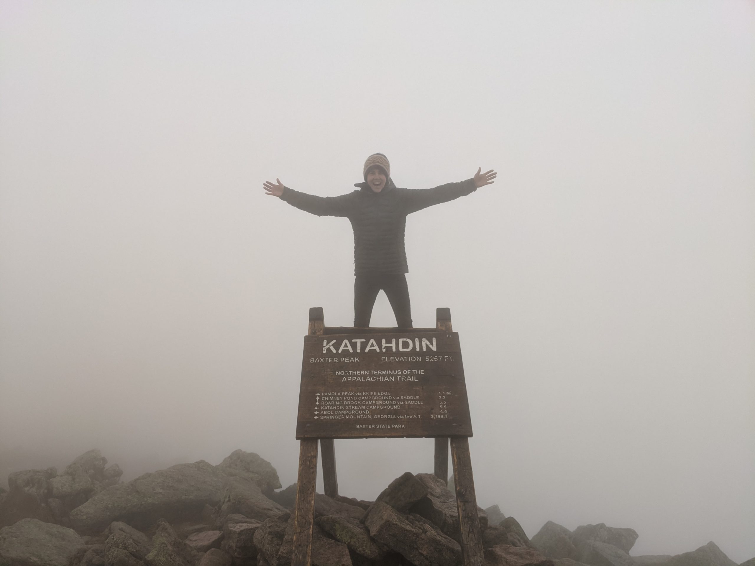
And then finally, albeit suddenly, a wooden silhouette, much like a large easel, appears about 20 feet in front of us.
It’s the sign. We’re here. We made it.
I’d thought about this moment so many times throughout my journey. There were days I wasn’t sure I would get here. Like the day in Virginia, when I sat down on the trail and cried because it was raining and I didn’t think it would ever stop. Or the many days in New Hampshire, when the challenging terrain and weather made me question whether I had the willpower to finish. There were also days, many days, when I wanted the trip to last forever.
I try to let the moment sink in. I thought I would feel emotional, but I don’t. I feel cold. My hands are wet. I’m anxious about the descent.
Jack and I hug. We take some pictures. And just like that, our journey has come to an end.
——
It’s now been a week since summiting. As I write this blog, the ending feels abrupt. And I think that’s how it felt in the moment, too. After 5 months, nothing really prepares you for the finish line. You just walk everyday and then suddenly, you’re somewhere else…
I’m still processing it all, but I know one thing for sure. There will be more long hikes in my future.
Thank you to everyone who followed along on this journey.
Thank you to all of the people I met along the way. The trail angels… those who opened up their homes, gave us rides, left water water caches, and made it clear that there’s an entire community out there rooting for us.
Thank you to all of the friends I made and the friends who visited me on trail. To Jack… Who knew I’d end up hiking everyday with that “sick guy” from the hostel. I’m grateful you ate those fried mushrooms so that our paths would cross. Thank you for sticking with me, for (literally) pulling me up mountains, and, more than anything, thanks for sharing your camp shoes.
Thank you to all of the beautiful, friendly deer who kept me company in Virginia. I love you.
And finally, a massive thank you to my family for supporting me and making this possible. For loving my dog and taking him in when needed. For visiting me on trail. For assembling and sending my resupply packages, even when I gave you very little notice. For decorating my resupply boxes (lol). For always sharing words of encouragement and so much more. I couldn’t have done it without you.

This website contains affiliate links, which means The Trek may receive a percentage of any product or service you purchase using the links in the articles or advertisements. The buyer pays the same price as they would otherwise, and your purchase helps to support The Trek's ongoing goal to serve you quality backpacking advice and information. Thanks for your support!
To learn more, please visit the About This Site page.

Comments 1
Congratulations on finishing your AT hike. A great accomplishment. David Odell AT71 PCT72 CDT77