 ">
">
Summit Sisters
I had spent a good year preparing to hike the Appalachian Trail – I read every book about the A.T. that was downloadable to my Kindle, became a member of Whiteblaze.net and read all their articles and forum posts of others giving their .2 cents of advice, purchased Awol’s guide and maps, joined a FB group of women my age that were also planning a thru-hike of the A.T., and acquired gear that was suitable for the A.T.
Then all of that came to a screeching halt when I abruptly changed gears and decided to hike the Pacific Crest Trail instead. Why, you ask? Well, first and foremost, I actually live in California and just by great coincidence, the PCT runs the length of California (as well as Oregon and Washington). I would be closer to home, be able to see my partner way more often as she can meet me in towns along the way (bearing my resupplies…part of my master plan…), and I am more familiar with the terrain, having hiked extensively in California and Washington. Muy bueno! 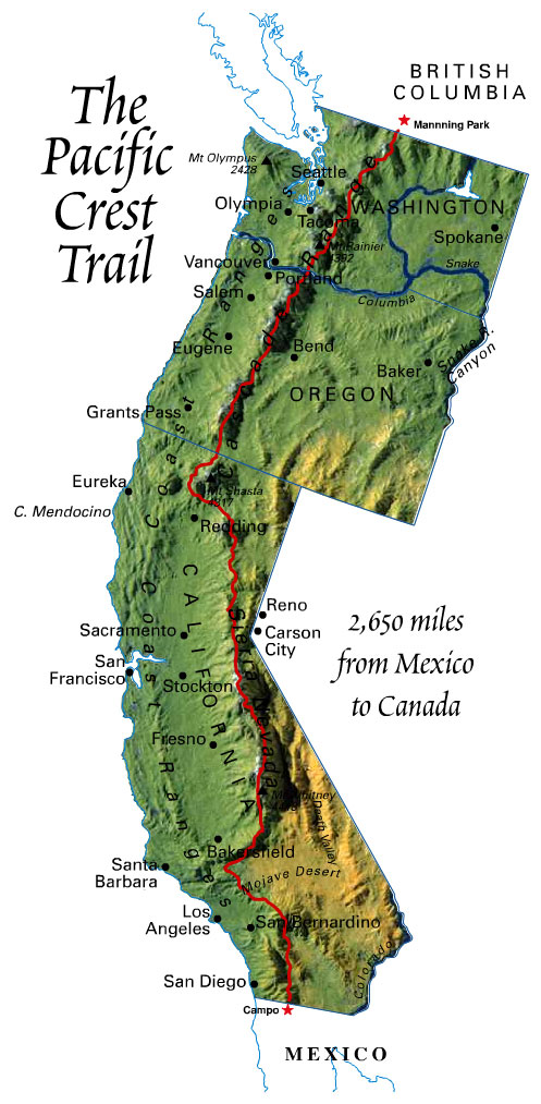 One would think that switching from one long trail to another long trail shouldn’t be a big deal…and one would be quite wrong if that was their thoughts. There are some pretty big differences between the Pacific Crest Trail and the Appalachian Trail. Let’s review a few.
- Mileage – the PCT is approximately 2,650 miles and the AT is almost 2,200 miles, making the PCT 450 miles longer. Egads.
- Shelters – the AT has more than 250 shelters found along the trail, with an average distance of 7.8 miles apart. The PCT has only a handful of shelters on the entire trail.
- Terrain
- PCT: Ranges from just above sea level to 13,153’, the highest elevation on the trail at Forester Pass in the Sierra’s (CA) and crosses over 57 major mountain passes. The first 700 miles are desert, and no, it is not flat. There are soaring mountains, canyons, and sand, lots of sand. You then hit central CA and the (dreaded) Sierra’s, where it crosses over eight named passes over 11,000’, still snowed in, requiring ice axe and crampons. Survive that and you will continue to the Cascades in Northern CA, with Mt. Shasta and Castle Crags State Park to look forward to. Oregon, from what I hear, is fairly easy travel, and you must really be booking at this point to make it through Washington to finish the trail and beat the snow in the rugged North Cascades. The trails are graded, so there are many switchbacks, making travel uphill not too strenuous.
- AT: Passes through 14 states with the lowest point at 124’ in Harriman-Bear Mountain State Park in NY and the highest elevation at Clingman’s Dome at 6,625’ in The Great Smoky Mountains National Park in TN. The trails go straight up over every mountain along the way. Every one of them including even the ones that are out of the way. About a quarter of the trail is in Virginia, at 544 miles, and Pennsylvania is known as “Rocksylvania” as the terrain is rocky and rough. The White Mountains are beautiful, but strenuous. The weather is dangerous and unpredictable and the terrain is steep and rocky. Make it to Katahdin in Maine, the terminus, and you will climb at times hand-over-hand to get to the top of it (I have climbed it and it remains as the hardest mountain I’ve ever summitted).
- People – about 2 to 3 million visitors walk a portion of the AT every year; each year thousands attempt a thru-hike and approximately 1 in 4 will complete the thru hike. Less than a thousand start the PCT every year with a completion rate of about 60 percent. The numbers may be higher this year due to the popularity of Cheryl Strayed’s book, “Wild.”
Some other differences are that the AT has more foliage, hence the title, “Green Tunnel,” where the PCT is way more exposed. This little fact had me scrambling to buy a new tent as my hammock will do me no good in the desert and hammock camping availability is sporadic until you reach Oregon. Both trails have bears, snakes, ticks (although fewer on the PCT), mice, hairy trail dudes, and other things that go bump in the night.

My New Tent - Big Agnes Fly Creek UL2 (I like my space)
I cannot say one trail is more difficult than the other because I have not hiked both these trails. I can say that I have read many opinions from those who have hiked both and from what I gather, the AT is more strenuous, as the trails go straight up and down and the elevation gain is equivalent to climbing Mt. Everest 16 times. The PCT has many switchbacks, but you must contend with more elements of Mother Nature, i.e., wind, snow, ice, the infamous Sierra lightening/hail storms, heat, etc. So, they both have their mental/physical challenges.

Sierra storm I got caught in. Thought I was going to die.
The last big factor is that the AT goes through more trail towns and the PCT is more isolated, making resupplying a bit more challenging. Not to mention taking those zero days in town with AYCE and comfy hotels a bit more sporadic. Hopefully that will just toughen me up.
I have Yogi’s guide, though, to get me through it all and I am confident this is the right trail for me.

"The" guide to the PCT
Honestly, the hardest thing about switching trails was not the trail itself, but not being able to hike with the wonderful women I bonded with through our FB page, the Summit Sisters.

Proud to be a Summit Sister!
What an incredible group of strong, tough ladies that are determined to hike the AT. We have shared thoughts and ideas, helped one another with our planning, laughed at jokes and stories, cried together over family losses, encouraged one another, and have developed a bond that will not be broken. I cannot wait to follow their journeys and have no doubt of their success.
Cheers to the Summit Sisters!

This website contains affiliate links, which means The Trek may receive a percentage of any product or service you purchase using the links in the articles or advertisements. The buyer pays the same price as they would otherwise, and your purchase helps to support The Trek's ongoing goal to serve you quality backpacking advice and information. Thanks for your support!
To learn more, please visit the About This Site page.

Comments 1
Thanks for the marvelous posting! I certainly enjoyed reading it, you can be a
great author. I will be sure to bookmark your blog and will eventually come back very soon. I want to
encourage you to definitely continue your great writing, have a nice morning!