 ">
">
The Presidential Range: AT Days 111-114
Zeacliff Pond to Nauman Tentsites, 16.3 miles
Jackrabbit and I were awake early, ready for yet again another long day in the mountains. A steep descent down to Zealand Falls Hut began the day, where free leftover breakfast was waiting for us. To our delight, a flat and smooth 5 mile section of trail followed, which was a nice reprieve from the constant climbing and descending.
We soaked in this scenic, cruisy section of trail before descending down to US Route 302. From there, an intimidating climb awaited us; 2,600+ feet of vert over roughly 3 miles up Mt Webster and onto the Presidential Ridge. The climb started off steep right off the bat, but wasn’t too technical until we arrived at 3,000 feet.
From there, it was very steep and technical rock climbing for the next ~1,000 feet of elevation. To make things interesting, rain had started to fall, making the rocks that much more tough to grip. This was another climb where one slip up or false foot placement can have very painful results.
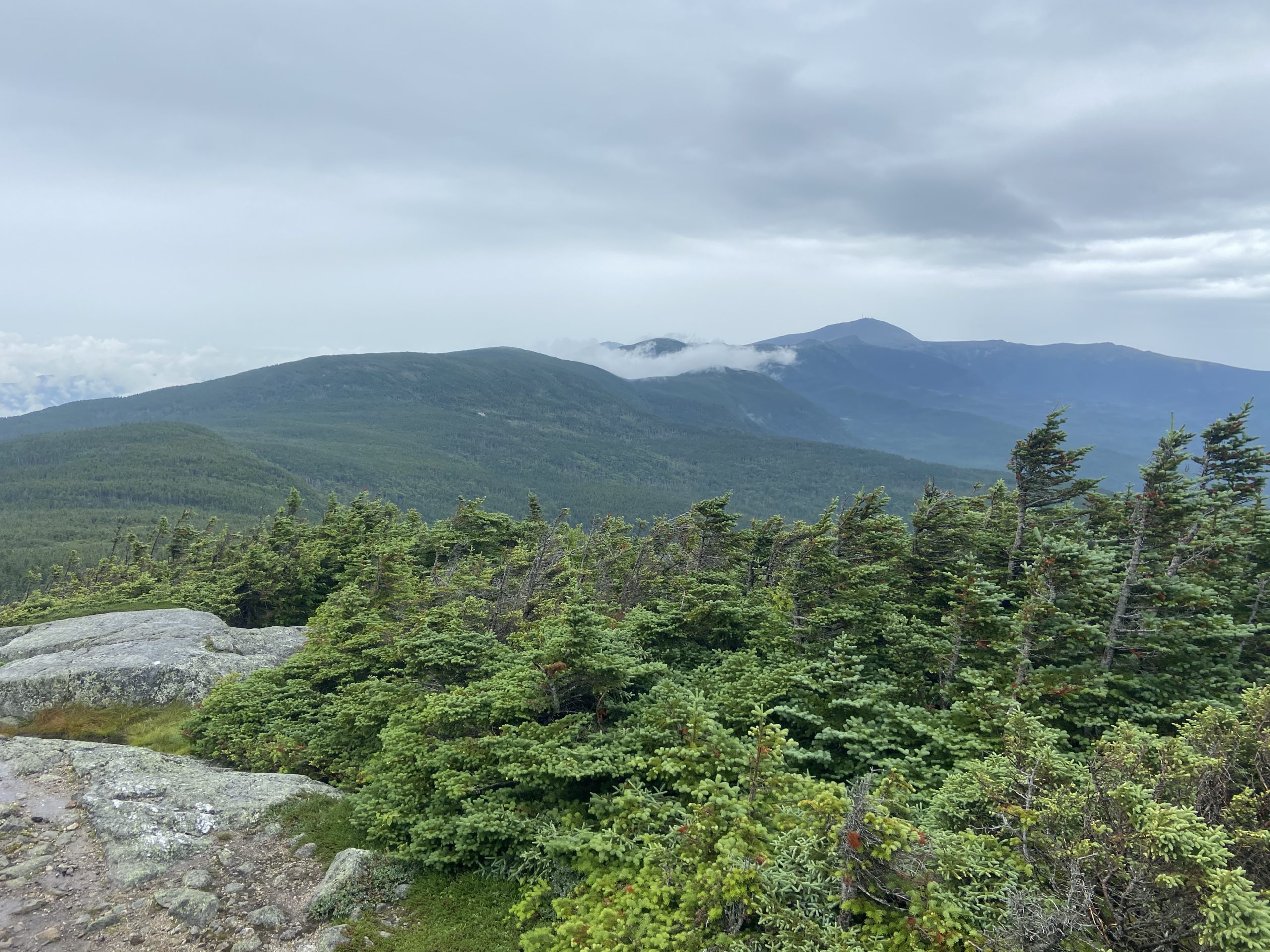
Stunning views made the tough climb rewarding, and the rain soon stopped. From Webster, the trail makes its way towards Mt Jackson, which requires more rock climbing to the summit. One of the best views I’ve ever seen awaited me at the summit; the entire Presidential Range can be seen, with a clear view of Mt Washington, along with other surrounding mountain ranges. I soaked in these fantastic views before hiking on another 2 easier miles to the Nauman Tentsites.


Nauman Tentsites to Lakes of the Clouds hut; 5.3 miles
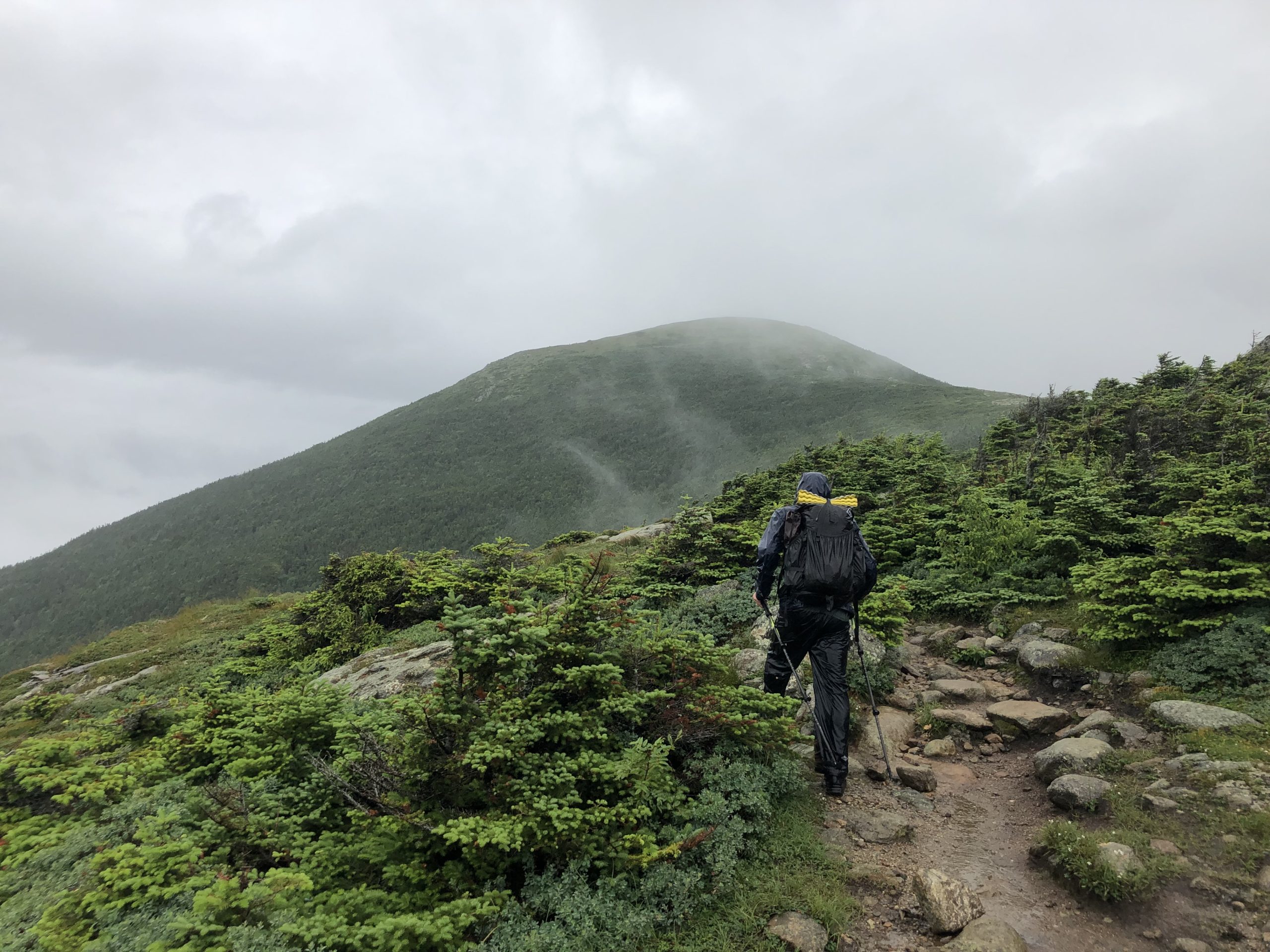
Heavy rain falling on my tent woke up me at around 11:00 PM, and by the time I was awake for good at 5:00 AM the rain continued. Breaking down camp in the rain is never an ideal way to start off a day of hiking. Jackrabbit and I had an ambitious day planned; 19 miles of traversing the fully exposed Presidential Range down to Pinkham Notch. We were just hoping the weather wouldn’t take a turn for the worse; as being above tree line in thunderstorms sounded pretty sketchy.
A short but steep ascent up Mt Pierce started off the day. We quickly got above tree line where very intense winds and rain greeted us. This weather was like nothing I had experienced before; if it was this intense at 4,000 feet, what would it be like on Mt Washington at 6,000 feet?
The weather calmed down slightly as we made our way through the rocky terrain above treeline. The clouds would occasionally break for a brief moment, offering fantastic views of the upcoming trail. Soaking wet and cold, we arrived at the Lakes of the Clouds hut, where we reconsidered our options over some hot soup and coffee. Each hut has daily weather updates posted, with today’s weather report reading “afternoon thunderstorms bringing heavy rain”
Needless to say, this is not what we were hoping to see. If we continued on the AT up Mount Washington, we would be committed to hiking the remaining several miles above tree line in heavy thunderstorms with no where to take cover. The safest option was to bail right there at the base of Washington and take a three mile side trail down to 2,000 feet of elevation, and head to the hostel we had reserved for the night.
A tough three miles down off the ridge wasn’t exactly ideal, but it definitely sounded better than the alternative. This day reminded me that we are always at mercy of Mother Nature out on trail, and weather can always throw a wrench into plans and there’s simply nothing we can do about it.

Lakes of the Clouds Hut to Lost Pond, 15.5 miles
Jackrabbit and I ended up taking a zero day the following day in order for our gear to dry out and to get our minds right for the remainder of the whites. We were well rested and ready to give the Presidential Range another go, this time in better weather. We had a steep three mile climb back up to the AT at Lakes of the Clouds Hut to get things started. It was very foggy out, and visibility was low as we got above tree line.
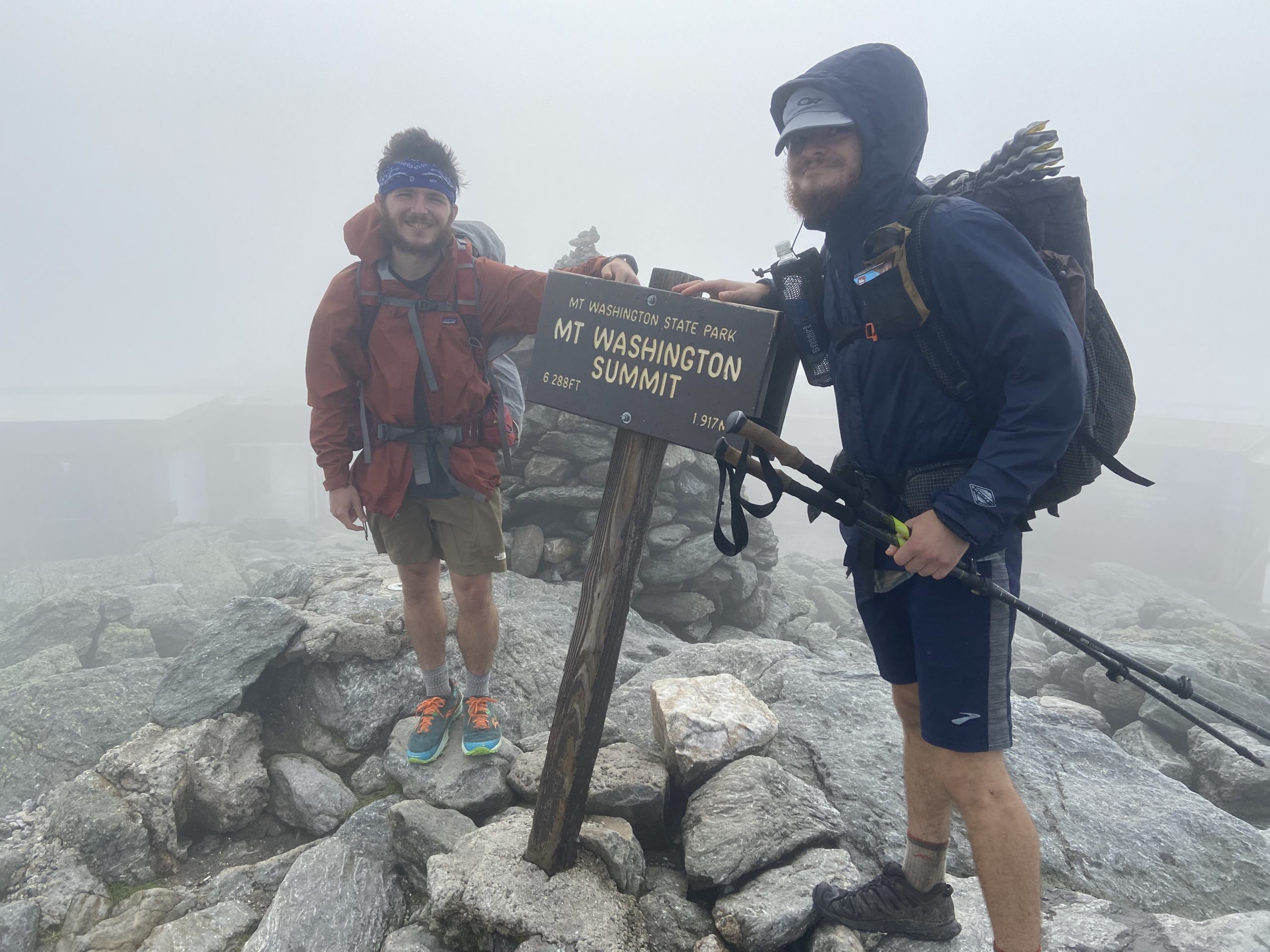
It is a 1.4 mile steep ascent from the hut to the summit of Mt Washington, the tallest mountain in the Northeast at 6,288 feet, which is home to some of the worlds most dangerous and unpredictable weather. There wasn’t any “trail” to the summit, as the entire mountain was all boulder fields with cairns leading up to the summit. Thankfully, the cairns were easy to follow in the fog, and despite the poor visibility I enjoyed the ascent and was just happy it wasn’t raining at this point.
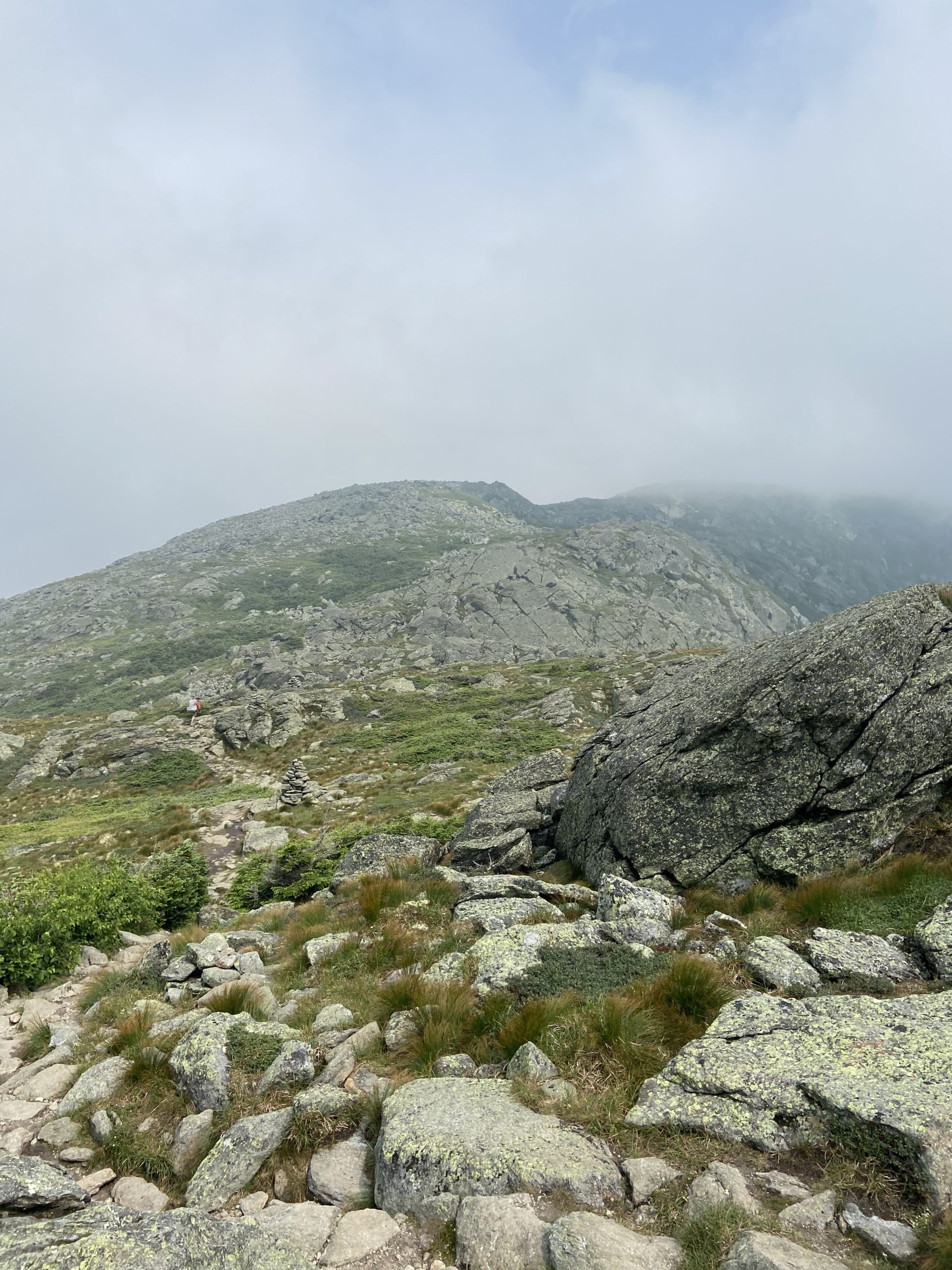
The summit of Washington was crowded with day hikers and tourists who drove to the summit. We didn’t hang out long as we snapped photos at the summit sign and began descending off the peak. At this point, a lot of the cloud cover had briefly cleared and we got fantastic views of our ridge hike that followed, before being engulfed in the clouds yet again.
It was 5 miles from Mt Washington to Madison Hut, which sits at the base of Mt Madison. Again, there was not much in terms of a trail up here, as large piles of rocks and boulders covered the entire landscape with cairns guiding the way. Visibility was very poor at this point and I couldn’t see anything other than the cairns right in front of me and the rocks at my feet. It was a very slow going 5 miles and I was relieved to arrive at the hut for lunch and coffee to warm up.
Feeling recharged, I rock climbed my way to the summit of Mt Madison. Some of the clouds had cleared up and I got some great views of Madison Hut down below, and the upcoming few miles of trail that lie ahead. For the next two miles I rock-hopped my way back down to treeline and descended all the way down to Osgood Tentsites. From there it was an easier 5 miles to Pinkham Notch Visitors Center where I caught up to Jackrabbit.
We opted to stealth camp close to the shores of Lost Pond less than a mile away, and reflected on an epic day of traversing the Presidentials before calling it an early night. It wasn’t the best weather by any means, but still an awesome experience. This just means I’ll have to return to the Presidentials on a clear, sunny day.


This website contains affiliate links, which means The Trek may receive a percentage of any product or service you purchase using the links in the articles or advertisements. The buyer pays the same price as they would otherwise, and your purchase helps to support The Trek's ongoing goal to serve you quality backpacking advice and information. Thanks for your support!
To learn more, please visit the About This Site page.

Comments 5
On of my favorite parts. Raw nature at it’s best. You’ll love Saddleback above Rangeley, ME.
Vince, aka the Dude,SOBO, 16-18, and beyond.
Congrats on hiking up Mt. Washington. I always see bumper stickers for cars that have made it up the mountain. I think hiking it deserves something better.
I am so enjoying your writing and your adventure. Can’t wait for you to cross the finish line.
It’s all downhill from here! Well, not really but you know what I mean. 🙂
That’s some rugged hiking! In December, 1987 I day-hiked with a couple of friends from Crawford Notch up to just above the tree line, where our water bottles froze and we were in 18″ of snow. We hiked a bit, lost sight of the trail and turned back. in summer of 1988, I finished that hike, solo all the way up Mt. Washington, arriving back at Crawford Notch after 9:00 pm in the dark. Then in summer of 1988, I backpacked, solo from Pinkham Notch, across Mt. Washinngton summit, down the headwall in a cold rain toward Spaulding Lake where, just before dark a couple of guys told me there were no tent sites available. Hiked another mile or so in the rain and dark until I finally decided to survive and pitched my tent in the middle of the trail. Next day, hiked through Great Gulf Wilderness, and back to Pinkham Notch.
Rugged Hiking!