 ">
">
Top 5 Fearmongered Sections of the Appalachian Trail (and Why You Shouldn’t Worry About Them)
fearmongering: the action of intentionally trying to make people afraid of something when this is not necessary or reasonable (from dictionary.cambridge.org).
There is so much fearmongering on trail, it’s ridiculous. Hikers tell each other about upcoming sections that either they’ve done and claim are crazy hard, or they’ve heard from other hikers are crazy hard. Over time, this creates an aura of fear or intimidation about a section of trail, sometimes creating the mindset that this section will be impossible.
This mindset can be very unhealthy for one’s mental health and motivation, leading some hikers to yellow-blaze around a section (skip by riding in a car), or slackpack the section to make it easier (carry a daypack rather than a full pack). Though I have my own opinions about each of these practices, I’m not condemning either. I’m just giving examples of ways that fearmongering can impact a hiker’s trail experience.
While I would bet that fearmongering occurs on all long trails, I only have experience with the Appalachian Trail, so this post will only be discussing popularly fearmongered locations along it. And why you should not be worried/afraid/intimidated by them.
The Foundation for This Article
This article began as an idea while I was still on trail as a way to combat the fearmongering that my friends and I had experienced. I made a list of all the places that I remembered worrying about the difficulty of, and then a description of my personal experience.
But then I began to wonder what the greater thru-hiking community thought of fearmongering on the AT. So over the last two weeks, I have conducted surveys on my Instagram and on here through a Google Form to determine if other thru- and section-hikers experienced fearmongering, and if so, what parts of the trail it impacted, as well as their resulting experience.
Here’s a summary of the results (listed south to north).

Fig. 1- Overview of sections that were fearmongered. This chart shows the overall categories of sections that hikers mentioned as sections they heard would be difficult and/or were intimidated by. In this article, I will break down specific places within these sections that were voted for.

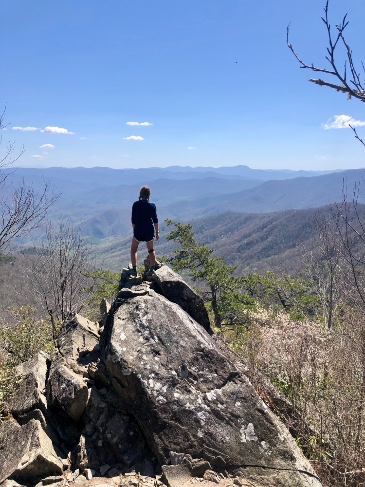
Blood Mountain, GA
Location overview: Blood Mountain is at mile 28.9 at an elevation of 4442 ft. There are a couple of hills to climb up and down right before it, but the final ascent to the peak of Blood Mountain is 756.2 ft of elevation gain over 1.2 miles for a grade of 655 ft/mi. The descent is 1,360.2 ft over 2.3 mi for a grade of 601.1 ft/mi.
What I’d heard: Rumor/research has it that the majority of hikers who quit their thru-hike attempt, quit after climbing Blood Mountain because it’s so hard. As evidence to this statement, there is a giant tree at Neels Gap at the northern end of Blood Mountain full of the shoes of hikers who have quit (or decided to replace their footwear, but mainly quitters). Also, Blood Mountain was the first part of the trail that I’d heard was hard, so it seemed like my first true test of my ability to thru-hike.
My experience: I climbed Blood Mountain on a very cold, foggy, and rainy morning. I kept waiting for the ascent to get hard, and then all of a sudden I could see the shelter that marks the summit. The descent was a little bit slick, which made it harder than the ascent in my opinion, but it still wasn’t bad. Possibly the hardest thing I’d done to that point, but that’s not saying much. I honestly didn’t think it was really that hard at all.
Other hikers’ thoughts: One person who voted for Blood Mountain in my survey said it was “a piece of cake,” and another said it was “way easier than what it was hyped up to be.”
Advice for conquering it: Take your time and you’ll be fine.
My expected difficulty: 5/10
Actual Difficulty: 1/10
(Both of these ratings are purely my opinion. 10/10 is impossible.)
Smoky Mountains National Park
Location overview: Smoky Mountain National Park has about 75 miles of trail inside its borders, beginning at mile 164. According to Guthook, it is home to the highest elevations on the trail.
What I’d heard: I started the AT really dreading the Smokies. I’d heard that it was the hardest part of the trail in the southeast, and was known for having horrible weather (aka cold weather, which is my kryptonite). I’d also heard that once you enter, there’s no way to town until you exit, so having enough food is critical.
My experience: The climb out of Fontana Dam is the only part that’s actually hard, after that it’s just smaller ups and downs. It was really cold and raining for the first three days, which sucked but definitely wasn’t the worst it could’ve been–I met people who hit it before and after me this year who got snow.
I definitely did not have enough food when I left Fontana and had to ration like crazy for the first half, but it’s okay because you actually can go into town if you need to. You can shuttle (or hitch, but it’s like 15 miles or something really far) to Gatlinburg from Clingman’s Dome or Newfound Gap. I shuttled with some friends from Newfound Gap, and we spent a day in Gatlinburg before shuttling back to the trail so we didn’t have to pay for a hotel room. Other than the lack of food on the first half, I absolutely LOVED the Smokies. They were so beautiful, full of great views and fun times with friends. It was a little crowded though because I hit it with a bubble and you have to sleep at the shelters, so it does form a bit of a bottleneck.
Other hikers’ thoughts: One said that the Smokies “weren’t difficult at all, but I got lucky that there was good weather.” Another said their experience was also great, but to “get there early before the bubble.”
Advice for conquering it: Fontana Dam is the only place on the AT that I would recommend people with no dietary restrictions to send a food maildrop to. Fontana Dam is supposed to have three places to resupply at, but only one was open when I arrived because one is closed Tues/Wed (I got there on Tues), and the other wasn’t opening for the season until next week. And the only spot that actually was open (the marina) had been hit really hard by the beginning of the bubble and barely had anything when I arrived. So send a maildrop to the lodge in Fontana Village if you want to guarantee that you will have enough food.
My expected difficulty: 5/10
Actual difficulty: 2/10
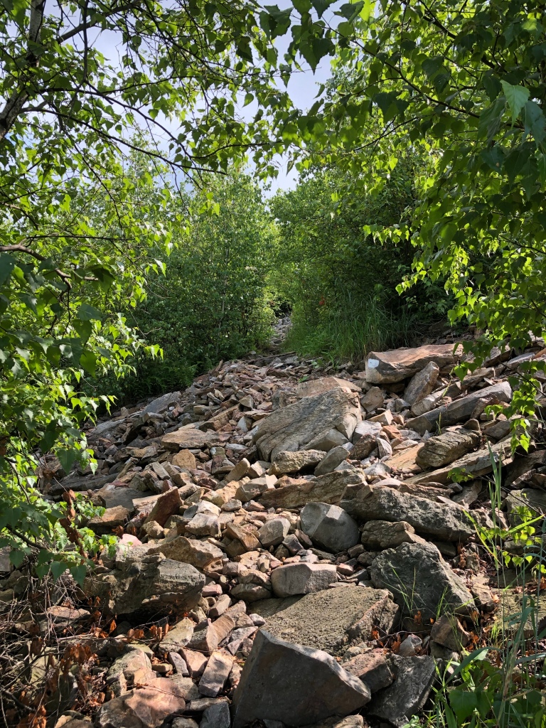
Pennsylvania
Location Overview: Really just all of Pennsylvania north of Duncannon. Which is about 147 miles beginning at about mile 1149 until the PA/NJ border at around 1296.
What I’d heard: Rocks. Tons of rocks. Nothing but rocks. Flat. But all of the rocks.
My experience: This is the only section of trail where the fearmongering was basically 100% accurate. I honestly was debating about including PA in this, but a LOT of other people mentioned it in my survey, so I decided I needed to. PA is not hard as far as elevation goes. The southern part (until Duncannon) is very beautiful, with lots of fields you walk through, giving a nice change from constant trees.
But after Duncannon, you only really climb 500 ft at a time which is nice, and you stay on a very flat ridge for like 12 miles before descending. But Every. Single. Step. Is covered in rocks. And there’s very little water (at least in July) because of all the rocks and ridges. Most of the time you have to walk 0.5 miles downhill off-trail if you want water. And, I hate saying that a mountain view is the same as any other, but in PA they are literally all the same. You see that exact same ridgeline that runs parallel to the one you’re on, with a few fields and lots of houses in between.
The only redeeming part of northern PA is the climb out of Lehigh Gap which is GORGEOUS. But otherwise, there’s a very good reason why I saw exactly 0 day- or section-hikers my whole time in PA.
Other hikers’ thoughts: Everyone who said PA was a section they’d heard was hard, all basically said the same thing: that it was”just as bad as everyone made it out to be,” but really “no biggie.” “Just rocky.”
Advice for conquering it: Keep an eye on how your shoes are holding out because the more you hike on rocks the faster they wear out. And try to keep a positive attitude, Pennsylvania is really more of a mental challenge than a physical one. Also, FYI, the rocks don’t end after Pennsylvania. But you do start getting good views again to reward all your effort, so the rocks are a little more worth it. And there’s water on trail again.
My expected difficulty: 4/10
Actual difficulty: 4/10 (due more to the mental difficulty than the physical)

Fig. 2- New Hampshire sections that were fearmongered. Many people mentioned either all of New Hampshire, or specific places within NH. This chart shows the breakdown of responses.
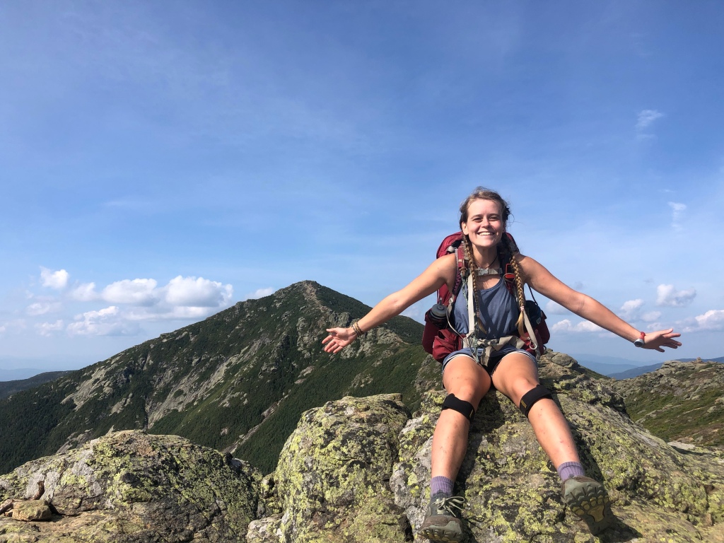
The Whites
Location Overview: White Mountain National Forest has about 117 miles of the AT within its borders, including tons of spectacular mountains. It begins at about mile 1789 and ends at about mile 1906.
What I’d heard: The Whites are the hardest part of the whole trail. The weather can be terrible and is rapidly changing. And the terrain is INSANELY difficult. Honestly, I was under the impression that the Whites were impossible.
My experience: Easily my favorite part of the trail, except maybe Katahdin. I was blessed with amazing weather—only a few thunderstorms that all came when I was under treeline and passed quickly. The terrain is very strenuous, but the views make it SO INCREDIBLY WORTH IT.
The Presidential Range and the Wildcat Range were the only two sections mentioned by name by the participants of my survey, but I honestly didn’t think they were any harder than the rest of the Whites. So very hard, but not ridiculous. My friends and I actually did all the mountains in the Presidential Range (so adding on five extra summits) in one day. Overall, I absolutely LOVED the Whites, and can’t wait to go back. They’re very hard, but not impossible like I’d feared.
Other hikers’ thoughts: Everyone who said the Whites, whether the whole thing or a specific part, gave some variation of “they were hard but so worth it.” Another hiker said it was “spectacular, felt like an adventure.” But don’t underestimate them, because one hiker said of Mt. Madison “it wrecked my knees going down and broke my trekking pole.” I broke my own pole coming down Mt. Moosilauke.
Advice for conquering it: Take your time on every single climb. Shorter mile days are wonderful, they allow you to savor the views and not wreck your body. And, if the weather looks like it might be bad before you go in, take a zero in Lincoln. You’ll be glad you did, the views are so worth waiting for.
My expected difficulty: 10/10
Actual difficulty: 8/10

Fig. 3- Maine sections that were fearmongered. Same deal as with New Hampshire. Some people heard all of Maine would be hard, others specified. Here’s the breakdown.
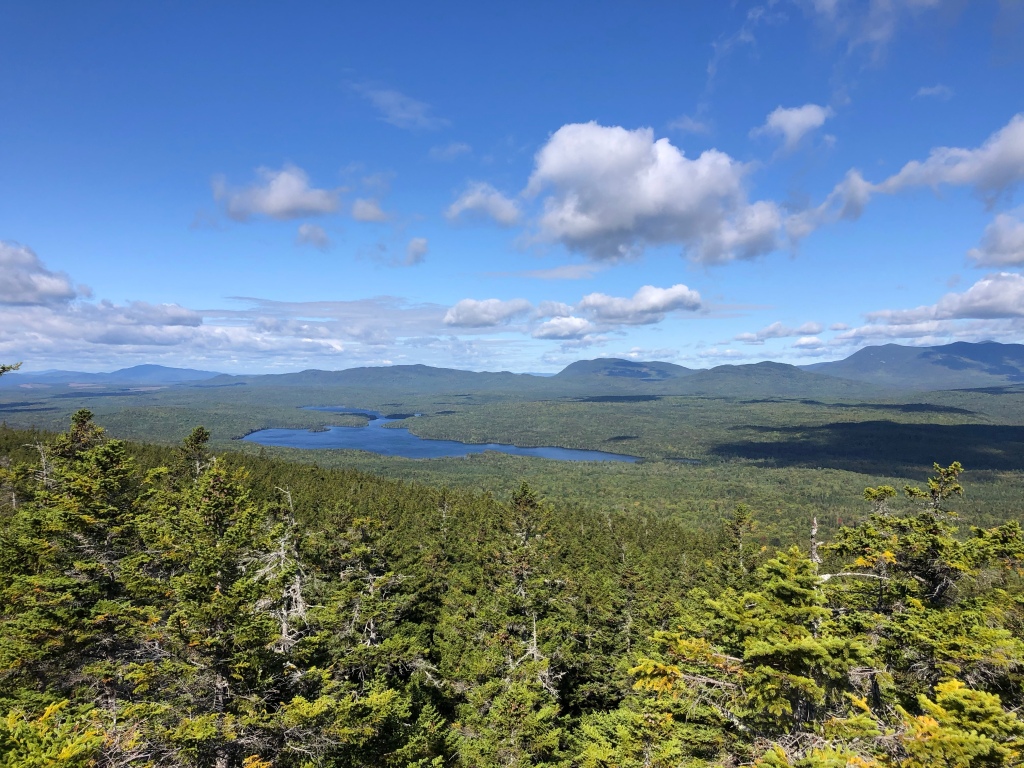
Maine
Location overview: I define Southern Maine as the 100 miles or so until Monson/the beginning of the 100 Mile Wilderness. It contains Mahoosuc Notch (a 1.1-mile rock scramble) and Mahoosuc Arm (a climb right after the Notch). The 100 Mile Wilderness is the last 100 miles before Katahdin.
What I’d heard: Southern Maine was said to be more of the same difficulty as the Whites, but I’d heard that once you reached Monson, the trail basically gives up until Katahdin. I’d been told by a friend that I could easily do 25s all through the 100 Mile Wilderness.
My experience: Southern Maine, in my opinion, wasn’t as hard as the Whites, but wasn’t easy. I did a lot of big mile days (which for me is 20-25 miles) and a lot of night-hiking in Maine because the sun was going down so early. Mahoosuc Notch was super fun, but I love rock scrambling. It took me and my friends 1 hr 22 min to do the whole mile. Mahoosuc Arm was annoyingly steep and had running water flowing down it, so it was pretty hard but not ridiculous. And the 100 Mile Wilderness was a breeze, especially the last 70 miles. After Whitecap Mountain, it is legit FLAT.
Honestly, I thought Katahdin was by far the hardest part of Maine. No one talks about how hard Katahdin is. I wasn’t prepared for it. I’d heard there’d be a ‘few’ rock scrambles. No, no. There’s about 1.5 miles of rock scrambling steeply up. So incredibly worth it, and very doable, don’t get me wrong. But Katahdin is the one part of the trail that wasn’t fearmongered and really surprised me with its difficulty. I guess that’s because it’s the end of the trail and no one is paying attention to difficulty anymore.
Other hikers’ thoughts: About Mahoosuc Notch, one hiker said “no big deal, just go slow.” And for the Arm right after it, another person said it was “not soo bad, as it was not rainy, and the fact that although it is as steep as announced, it is not wide and there are many roots and trees on the side to secure us in case we slip.”
Advice for conquering it: Take your time. Enjoy the views.
My expected difficulty: 8/10
Actual Difficulty: 7/10 for Southern Maine, 4/10 for the rest, 8/10 for Katahdin

Fig. 4- All responses of sections that were fearmongered. This is a breakdown of every single response people gave to my survey, so basically, all the other charts combined into one.
So that’s it, that’s the top fearmongered parts of the Appalachian Trail. Instead of writing a conclusion that just repeats what I’ve already said, I’ll leave you with two quotes from my survey that really summed up how I felt hiking through these sections.
“I just kept telling myself ‘I have made it to the top of every mountain I have attempted so far. I can make it up this one too.'”—A hiker
“I feel some of the hype helps you feel like a hero, once you’ve completed it.”—Another hiker 

This website contains affiliate links, which means The Trek may receive a percentage of any product or service you purchase using the links in the articles or advertisements. The buyer pays the same price as they would otherwise, and your purchase helps to support The Trek's ongoing goal to serve you quality backpacking advice and information. Thanks for your support!
To learn more, please visit the About This Site page.

Comments 20
Thank you, Ms Monkey Toes!
“Don’t rush. Take it as it comes. You’ll be fine” seems the most consistent advice I have heard for the entire trip.
Even at the tender age of 71 I am much more concerned about the mental challenge.
Blessings,
Steve
Trail information is only as good as the source. If someone is giving advice about conditions of places you have not been, try to find out what they are saying about places you have been, then adjust accordingly. Also, always have a plan B and plan C.
Well written article. I totally agree. On my 2019 thru of AT, I was constantly telling myself, “I made it through the Smokies in below freezing, icey rain and snow, often having to tent because the shelters were full, I GOT THIS”.
The 1.1 mile Mahoosic notch is clearly the hardest mile on the whole trail. (I guess doing it in the dark and the rain at the end of a long day made it worse). I found I was using a lot of my rock climbing skills and making some big jumps I felt sketchy on. Sometimes the poles seemed very helpful, but not when I need strong hand grips. long climbs just didn’t seem like a big thing once I was acclimated as long as I went at a pace to not get badly winded. What I dreaded and have never really experienced was days long of solid rain. To me, that would make the best conditions seem really tough
Great post on the fear mongering sections. Happy that you can relive your hike with continuing post.
What makes the White Mountains fear mongered is the weather. You were very lucky, I would suggest you try hiking them in bad summer weather. Then see what you think.
Additionally, I noticed you failed to mention the White Crosses on/around Mt. Washington, it’s posts like yours that cost NH hundred of thousands of dollars in rescue costs. Not to mention the hundred of thousands of labor hours of volunteers in those rescues.
Anyone doing the A.T. should read everything about Geraldine Lagay’s hike & death!
What costs many dollars in rescue attempt are idiots. She never wrote not to be conscious about the conditions, but rather not let all the doomsday prophets out there tell you what you can or cannot do.
I don’t remember seeing any white crosses around Mt. Washington, but I do remember seeing tons of turists in the area and on top, getting a ride in a car or the toy choo-choo and then taking pictures with the sign as if they are superheros. I bet is that the rescue attempts are because of these types of visitors and not because of thru hikers.
Everyone on the AT and especially on social media should take a chill pill. You are just spreading unnecessary panic.
We hiked a Presidential Traverse a few years ago. The most difficult section was ascending to Webster Cliffs. Hiking across the cliffs was unsettling…… Terrifying!! The rest of the trip was strenuous at times, but so amazing!! Our weather was great, except for a bit of rain one of the days. We stayed at two of the huts, which was fantastic. ???
I agree with your list, but I believe you seriously downplayed the role of weather in the Whites. The Whites are a whole different animal if you run into bad weather (which is not uncommon). It sounds like you had generally good weather in the Whites, so consider yourself lucky! I have volunteered with SAR in the Whites and can’t begin to tell you how much weather can factor into you having a good day or bad day on the trail in the Whites. I don’t think one needs to fear them, but they do command more attention and respect than other sections of AT.
Hey Monkey Toes, Great article! I’m a thru hiker wannabe who found your info incredibly helpful. Something tells me this hike will make you a much better climber!
As a PA resident I have done many section hikes on the AT in PA. 500′ climbs were mentioned but several of the gaps are 1,000 feet. As far as the rocks go, I would say its really not too bad up until you reach RT 501. I’ll be hiking from 501 to Port Clinton in two weeks and we’ll see how that section is. When I did a GA to Uncle Johnny’s trek in the winter of 2018 I had 16″ of snow in the Smokies and the trail was full of rock and roots which to me. doesn’t make PA seem all that bad.
Great article, thanks! As a section hiker who’ll be tackling northern PA this spring (gotta do it someday, might as well be now), it was nice to get your insight. Planning on taking my time and taking it easy on my 60+-year-old knees and feet!
One of the most sensible realistic posts on the AT that I’ve read. Thanks
I found that some of the “hardest parts” were easy for me if I hit them in the morning when I had the most energy and parts no one mentioned were hard for me at the end of the day (or if I was having a bad day). Really, the hardest part of the AT is readjusting to life after you return home.
Great Post. Enjoyed it, nothing like a little perspective.
Hey Monkey Toes! Thanks for the great article. I thru-hiked in 1987 “Low Gear”. I agree with your article 100%. I personally hate fear mongering. For me the trail was 80% mental, 15% practical (taking care of physical body) and 5% luck. The above comments about weather risks are true but fall in to the practical category. Your boots and weather are both pass/fail. You must be on top of them or you will fail. I have been a firefighter for the past 35 years and still measure everything against the AT. It still stands as the hardest thing I have ever done. That said, if you can do the AT… anything is possible… And for those yet to start… It really is as easy as one step at a time. Study, Plan, Prepare and then get out there and do it!
I maintain the southern side of Blood, so I climb it all the time. I have never understood the hype. I’ve hiked all of Georgia multiple times and I don’t think Blood ranks in my top 5 difficult climbs in Georiga. 🙂
I’m always impressed by your ability to write about complex topics in an understandable way.