 ">
">
Training Hike #3: Columbine Trail (Cheyenne Mountain)
Progression and Proficiency
For my third training hike I chose Columbine Trail which slices through the Cheyenne Canyon in Colorado Springs. This trail is an out and back route of 7.6mi in length, 1607ft in elevation, and is rated as “moderate” in the All Trails app. The trail is multiuse meaning hikers, horseback riders, mountain bikers, and dogs are allowed. I encountered hikers, one mountain biker, and two hikers with dogs. Average completion time is 3h 52min.
Weather and Clothing
It was 44 degrees when I pulled into the parking lot at the start of the trail. I was wearing Altra Timps, Darn Tough cushioned sole socks, Kuhl Renegade pants, a Merino Smart Wool 150 1/4 zip, a hat and Oakley M Frames. No gloves or toe warmers on this one. I carried my Osprey Exos 58L packed with about 25lbs and Z Pack Carbon Fiber trekking poles. I’ll add my gear list at the bottom of the post if you are interested in any of my gear.
Start Point and Trail Composition
The start point is a short walk from the parking lot and clearly marked as there are different trails which zig and zag out of the canyon. Trail composition is hard compacted dirt covered with pea gravel. Gravel and rocks ranged in size from dime to fist to foot size. At the start the trail is wide with plenty of room and parallels a stream with clear running water. Once you cross over the first intersection, the climb up begins. The width of the trail starts to narrow to around 4ft at it’s widest and 2ft at it’s shortest with STEEP drop offs on one side.

Steep drop offs!!

The majority of the first two miles is uphill at ranging gradients from 6% to 29% traversed by switchbacks. There are a few stretches of straight trail, though no more than 200m in length. The pea gravel is tricky on steeper parts. The trekking poles helped out with balance and grip. I noticed some bear poop off the trail at one point so I turned off the Active Noise Cancelling on my headphones. Stay alert, stay alive!
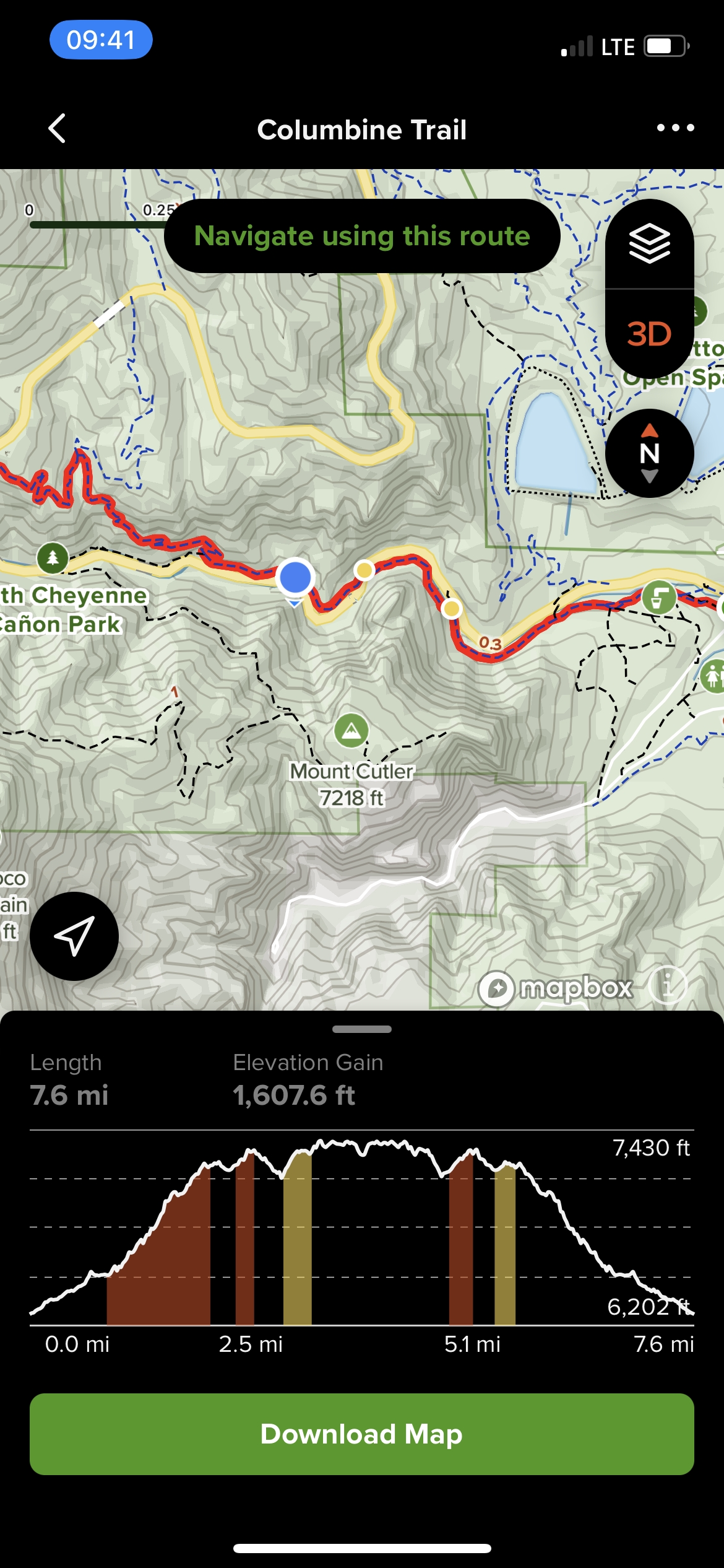
No Blazes
There are no blazes to follow on the trail. There are very few signs to point the correct direction with the majority of them either stolen or just poncho-poof gone. Luckily the All Trails app was on point at a couple of confusing sections. The GPS function is very beneficial and you can immediately tell if you are going the correct way. I’m not a big proponent on using GPS, but I did not have a map on me and wasn’t keeping a pace count so the app came in handy. Screen shot of what the platform looks like below.
Turn Around Point
As you can see on the elevation profile above, there is a steep descent before reaching the true turn around point. This descent then becomes an ascent on the way back (what goes up must come down and vice versa). It was a pretty steep section with great views along the side of the trail. There are multiple stopping/look out points to take some great shots. Once at the turn around, I sat down on a log, ate a oatmeal peanut butter bar, and downed my 1liter of Nuun tablet water.
One quick point on my Nalgene bottle drama. This time I secured it 0n the outside pouch of my pack. It fit perfectly, though it was hard to reach throughout the trek. This Nalgene bottle thing is a work in progress. On the positive side, the Goal Zero solar pad charged the battery bank to almost half power in a short 3hr span. The wind picked during the rest stop to 15-20mph sustained and gusts above 20mph. I was refueled and ready to head back down.
This is view from the turn around point. You can see a bit of a white rock face and there is a waterfall off to the lower right side.

Quick Descent and Finish
It was a quick descent minus the one small ascent on the elevation profile above. In sections where the pea gravel was more than average, it was a little tricky (not afraid to admit I almost busted it once or twice). Trekking poles helped with stability again and saved my knees from any pain. No hot spots on my feet, legs felt strong, and no back or shoulder pain throughout the hike. The Osprey Exos is such a great pack and other than my Nalgene bottle dilemma, I am wed to it forever.
Here are the final stats:
- Distance: 7.98mi
- Time: 3:17:12
- Avg Pace: 24:42
- Avg HR: 145BPM
- Total Cal: 2.2kCal
- Elevation Gain: 1,487ft
I was happy with those stats and building more proficiency with equipment usage and feet toughening. 8mi is about the distances I aim to cover for the first 10x days on the AT. I’ve crafted a final training plan based off these three training hikes which I will share in my next post. The plan consists of a mixture weight lifting, hiking, biking, skiing, and proper nutrition. With a start date of 16 February 23, I have 98x days left before “D Day”. No time to waste (que Tom Hanks talking to Wilson in Castaway).
Quick shout out: Happy Veterans Day to all those serving or you have served!! You and your families sacrifices to our great republic do not go unnoticed. Little factoid: Veterans Day honors the living and Memorial Day honors the fallen. Thanks for following along! As mentioned above, my gear list is below (I know it states 15lbs for my list, but my pack is consistently around 20ish-maybe I filled it out wrong?).
“The brave men, living and dead, who struggled here, have consecrated it, far above our poor power to add or detract. The world will little note, nor long remember what we say here, but it can never forget what they did here.”
~16th President of the United States, Abraham Lincoln~

This website contains affiliate links, which means The Trek may receive a percentage of any product or service you purchase using the links in the articles or advertisements. The buyer pays the same price as they would otherwise, and your purchase helps to support The Trek's ongoing goal to serve you quality backpacking advice and information. Thanks for your support!
To learn more, please visit the About This Site page.

Comments 3
As always, great article!
Regarding the difference between your gear list weight and actual weight, are you using the weight the manufacturer provided or did you weigh each item? And are you weighing it without food, water and fuel in your bag? I ask because it took me way longer than it should to learn that consumables aren’t normally factored into base weight.
I’m currently working on my gear list and weighed each item on a kitchen scale that measured down to a tenth of an ounce. There were some noticeable discrepancies between listed weight and actual weight. And it was a good to completely take apart my kit then individually weigh and repack each item. Not sure it will explain a ~5lb difference, but I’d recommend it if you have the time.
Thanks for the suggestion bro! I have not done that and it might explain some of the discrepancy. Other than small food items and a liter of water, that’s pretty much all I’ve carried. No stove fuel which I know will add at least another lb or more depending on the size. Appreciate the feedback!