Day 120
I packed up all my gear and after breakfast headed back on the trail solo. It was bummer again to be on the trail alone after having hiked with Ben for the last week, but with fewer than 500 miles to go I set my mind on the task ahead and started forward. My food bag was very heavy with too many snacks, and with an increase in temperature back into the 80’s I started struggling immediately on the first hill. After huffing and puffing my way up for a long time and running out of water I finally reached the top and started down the hill. Fortunately I ran into water a little past the Stony Brook Shelter, and I was able to fill up my bottles before continuing on.

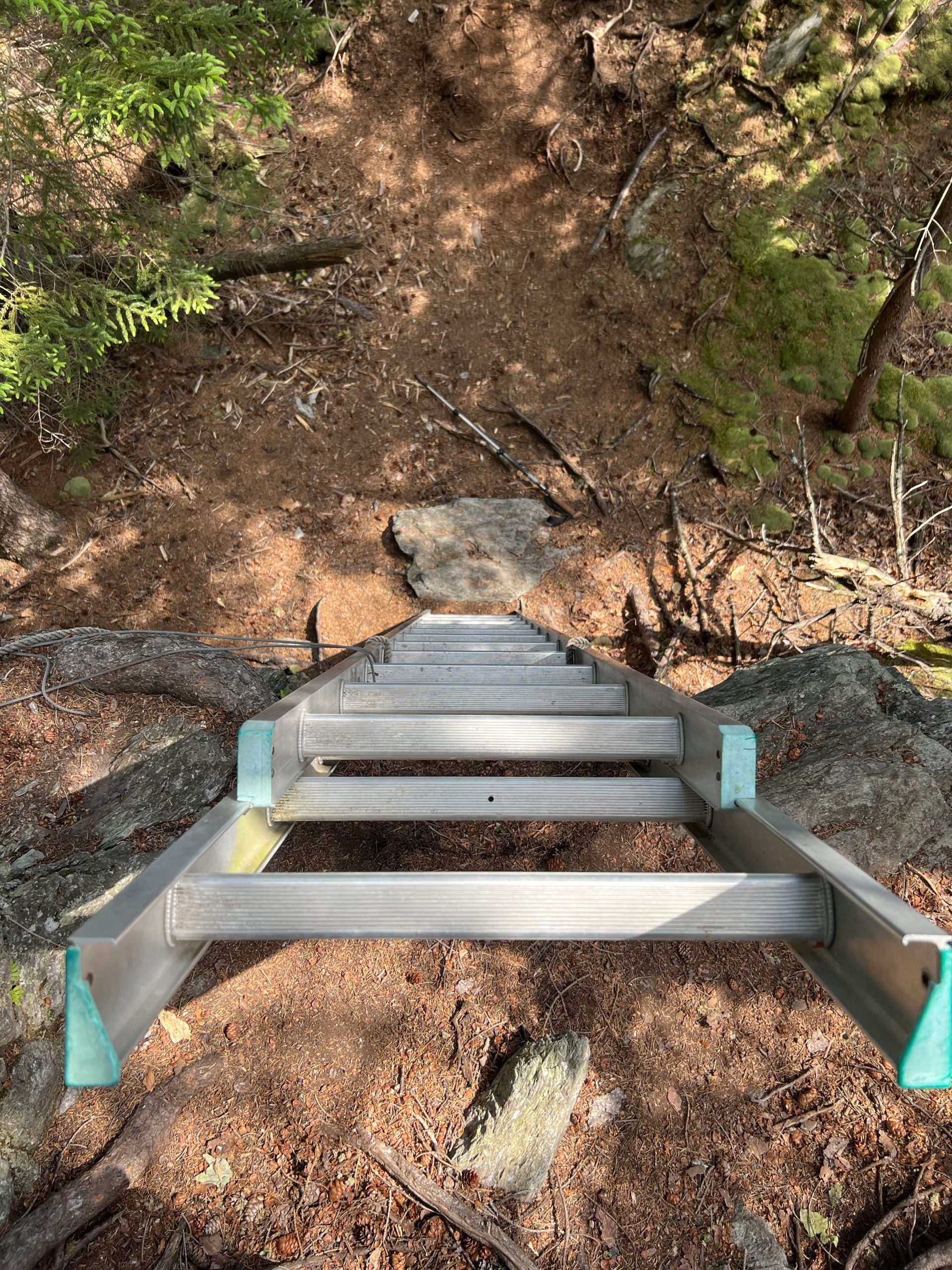
Sometimes the trail isn’t dirt or rocks, it’s a metal ladder tied to a boulder!
The next hill wasn’t as steep and I was able to make better time and feel less tired as I went up and down the wavy hills toward a lookout at the top, although like many “lookouts” on the AT this one was overgrown and no view was visible anymore. I wasn’t too disappointed by the lack of a view because I found a tiny stealth sight near the top of the hill and set up my tent for the evening. I was glad to get away from the bugs, which had been buzzing in my ears all afternoon, and relaxed in my tent for a while before making dinner and getting ready for bed.
Day 121
In the morning I got going and started sweating almost immediately, it was another hot day. The terrain quickly proved to be mostly made of PUDS (Pointless Ups and Downs), with the trail going up and down some fairly steep hills most of the morning. I put on my audiobook fairly quickly in an attempt to distract myself from the heat and hard hiking, which kind of worked, but I still wasn’t feeling great about the day. In the early afternoon I turned right at a road crossing and headed down to the Teago General Store in South Pomfret, and grabbed a tasty sandwich and lemonade before heading back out into the peak heat of the day. I slowly made my way up and down another series of hills, but was trending upward, and paused to sit on a bench at a hilltop to recover for a while before continuing on. Finally around 5 pm the temperature started cooling off a bit and I found myself finally getting in the groove for the day. I passed the Thistle Hill shelter toward the top of the series of hills and started heading mostly down hill toward the town of West Hartford. I popped out along a road a few miles later and crossed over to a trail angel’s yard, where I grabbed a soda and chatted with another hiker before heading into the nearby barn and grabbing a cot for the night.
Day 122
I slept in a little bit, which was fine by me because it was rainy outside, and sleeping in kept me dry longer. Eventually I got moving and set out across West Hartford in my rain jacket. Once the trail got back into the woods it started heading up another hill, and I started sweating under my rain jacket pretty quickly. Eventually I rolled up my sleeves and took off the hood, preferring to be slightly cooler even if that meant getting wet. After a couple hours the light rain petered out, and I was heading downhill toward Hanover. The trail emerged onto another road, and I started the fairly long road walk into town. I crossed the bridge spanning the Connecticut river which also marked the border between Vermont and New Hampshire before the houses and college buildings started appearing around me.

State #13
I stopped in town for some lunch and a break in the library to charge my phone, and it felt really nice to be able to sit and read a book for a couple hours while my phone was juicing up. Eventually I slung my pack back on and walked around most of the Dartmouth athletic fields before the trail entered the woods again. The terrain was steep with a lot of large boulders, until it passed over the top of the Velvet Rocks hill summit, then the trail became a little smoother as it meandered through some fields and wetlands. Around 8 pm I crossed Mink Brook, and set up my tent right next to the burbling creek. It was a very peaceful tent site, and I dropped off almost immediately.
Day 123
After a great nights sleep I headed out feeling pretty good. The day started off with a climb up to the Moose Mountain south and then north peak, which wasn’t too tricky of a climb, and had a couple nice views. The descent felt longer than the climb, and once I reached the bottom the trail immediately started going back uphill to the top of an unnamed mountain that was almost as tall as the Moose Mountain peaks. This climb also felt steeper, and I took my time reaching the top, which opened up onto some ledges with views of the nearby peaks. The top didn’t flatten out but turned right back down, and I made my way downhill, pausing for lunch halfway down. After reaching a road the trail again headed back up, and I started climbing the third mountain of the day: Smarts Mountain. This mountain was the largest of the three, and started off with a steep climb up to some large open sheets of rock that provided cool views of the area and the peak ahead.

Some nice rock slab hiking reminiscent of New York
I scrambled up the rock expanses before the trail headed back into the woods. After a brief flat section during which the trail curved from the top of one ridge around towards the peak, the trail steepened more than any other climb earlier in the day, and I hauled myself up and over roots, boulders, and even a rebar ladder. Despite only being about a mile, this last section took me a long time, and I was glad to finally spot the tower at the top and start back downhill again. I took my time on the descent, but it wasn’t as steep as the climb had been, and a couple hours later I crossed the small bridge over the cascading Jacob’s Brook, and saw the stealth site I’d been looking out for. The campsite was cozy and even had a couple small wooden benches, and I happily sat down on one to make dinner after throwing up my tent for the night.
Day 124
The morning started with an increasingly rugged climb up Mt. Cube, which was definitely more of a steep pyramid than a cube shape in my opinion. There were awesome views of the surrounding mountains from the bare rocky top, including a view back at Smarts Mountain which I climbed yesterday.

A look back at Smarts Mountain from the top of Mt. Cube
The descent was just as steep as the ascent and made my knees sore as I eased my way down. Toward the bottom I stopped for a rest, and met my first SOBO (besides Aquaman back in April, but he wasn’t a traditional SOBO), we chatted for a second about what to expect in the Whites, before he kept heading south. I’m sure he’ll be the first of many SOBOS I meet in the next few weeks. After my break I kept going downhill, which fortunately flattened out a bit and gave my knees a bit of a break. After reaching a parking lot, the trail headed back up and crossed through some marshy are before heading up the small Mt Mist. Maybe due to the marshy terrain the flies and mosquitos were out in force, and during the afternoon I had to stop to fish five flies out of my eyes, super annoying! Pretty soon I crossed another road, and officially entered the big bad White Mountain National Forest. I was feeling more trepidation than I had since starting at Springer, because the Whites are known to be the hardest section of trail and I’d been hearing horror stories about them ever since I started researching the AT. Luckily for me the first few miles weren’t too bad, the first tough climb was coming up tomorrow, so I was able to keep up a good speed and swat away the flies while I walked. The biting mosquitoes and warm temperatures were starting to make me grouchy in the late afternoon, and I struggled to enjoy the hiking for a few miles, until I crossed a road and started the last mile to camp. The trail paralleled Jeffers Brook for a while, and I spotted a small waterfall before turning into the Jeffers Brook Shelter. I was intending to stay in the shelter, but after I set my pack down and started cooking even more mosquitoes descended, so I set up my tent while my dinner cooked. After dinner I walked to the waterfall and tried to rinse off some of the bug spray and sweat on my body before heading back to my tent for the night.
Day 125
Today I really began the challenging Whites by starting off my morning tackling the climb up Mt. Moosilauke. The trail wasn’t too tricky at first, but gradually became steeper, which meant I had to focus on carefully placing my feet on the roots and rocks, and moved more slowly. I got in the zone a little way up, and managed to cruise my way slowly up the mountainside without too many issues. The landscape slowly changed from hardwoods to evergreens, and even these slowly decreased in size until I was hiking next to small Christmas tree sized trees that were barely taller than I am. Somewhere towards the end of the ascent I passed the 1800 mile mark, but I didn’t see the typical twigs marking the spot, so I made one myself a little while later once I realized that I’d passed the milestone.

1800 oh boy oh boy
Just a couple hours after I’d started I reached the south peak junction, the trail leveled out for a bit, and I could see the north peak up ahead of me as well as peeks of the nearby mountains through the trees and clouds. The wind was picking up, and as I pushed to the summit of the northern peak I rose above tree level and was hit by winds stronger than I’d experienced since back around Roan Mountain. I paused to put on my puffy jacket near the summit before I followed the tall cairns to the sign marking the summit.

At the summit!
There were misty clouds racing all around me in the strong wind, and I paused for a few minutes to take in the brief glimpses of the views before they were covered up by clouds again. Eventually I got chilly even with my jacket and I had to start down the mountainside. I’d heard a lot of daunting rumors about the descent down Moosilauke, but at first the trail was very gradual and not too tough as it wound below the trees again and started down. Eventually I passed the Beaver Brook Shelter, and the grade did get a good bit steeper, but it remained easier than I thought it would be. At this point I think I’ve probably experienced some of the steepest and roughest terrain the AT has to offer, and while this descent was steep and had many big rock steps, there was no rock scrambling or new challenges thrown at me, just tough terrain for longer than most descents, but I knew I could handle it. I slowly made my way down the rocks, and at one point a small trickle of water crossed the trail, and started tumbling down the rocks to my left. As I kept heading down this tricky turned into a small creek, then a larger cascading brook that formed pretty waterfalls right next to the trail.

When the descent has waterfalls and views you know it’s a good one
I really enjoyed the rest of the descent, even though I was taking it very slowly, and after a couple more hours the grade finally lessened and I was able to end my day at the kinsman notch parking lot. While I felt pretty good about the day, it had taken me almost six hours to hike the 8.4 miles over the mountain, a drastic decline in my hiking speed from the previous days, but that’s just how the Whites are going to go. I waited around for a while until my shuttle arrived and whisked me into North Woodstock for the night for a resupply and night in bed.
Day 126
For the first time so far during this hike I decided to slack pack over the Kinsmans. This meant keeping my hotel room for a second night, leaving all my heavy gear in the room, and hiking the sixteen miles between the kinsman notch and liberty springs trailheads mostly unencumbered before getting a ride back to town for the second night. Sounds easy right? I thought so, but the difficulty of the Whites was about to drastically increase. At first the trail wasn’t too tricky, a climb up from the road and then some fairly easy ups and down leading up to Mt. Wolf. No problem, I was making good time. The descent from Mt. Wolf is where things started taking a turn for the rugged. Soon I was scrambling down rocks, and trying to wind my way around deep patches of mud and blowdowns blocking the trail. After a while I arrived at Eliza Brook where I ate a quick lunch before starting the uphill climb to South Kinsman Mountain. The ascent wasn’t too bad for a while, and the trail passed a cool bog called Harrington Pond, that had great views of the area and the rest of the climb I still had to do. After the bog the trail got so much harder, with hand over hand climbing up boulder piles that felt like it went on for miles, even though this final push to the summit was only one mile long.

Easy peasy
Finally I crested the summit, and looked around at the huge view for a bit before I continued on, descending and ascending the small saddle between the south and north peaks before finally starting down off the Kinsmans. The descent was more of the same for the most part, but thankfully my knees weren’t feeling too bad and I made my way down without any issues. I passed the Lonesome Lake Hut, the first hut I’ve seen so far in the Whites, and grabbed a pretty picture of Lonesome Lake.

Ooooh ahhh
I wish I could’ve hung around and relaxed by the lake, but at this point it was getting late in the day, and I still had three miles to go, so I pushed on. Looking of FarOut the grade of the descent lessens after passing Lonesome Lake, and I’d expected the trail to be nice and easy for this last stretch, but unfortunately the trail was still made up of mostly large rocks and roots, so I wasn’t able to pick up my pace like I’d hoped. At this point I was getting tired and a little frustrated at the difficulty of the terrain even in this “easier” section, and I felt pretty grouchy for the last couple miles as I slowwwwwly made my way down to the Liberty Springs trailhead. At the junction of the AT and the trail to the parking lot I turned onto a paved bike path, so for the last mile I managed to cruise with the ease I’d been hoping for. Finally I arrived in the parking lot, it took me 10.5 hours to do the 16.4 miles, even without carrying most of my gear, that’s about 1.5 mph! I was exhausted and was glad to see my shuttle arrive a few minutes later. I devoured a burger in town before heading straight to bed for the night.
 ">
">


Comments 1
Love the pics. Good luck!