Day 126
After a slow morning in the hotel room avoiding some light rain, I set off uphill under cloudy but dry skies. I had a huge day ahead of me since I was starting off at 1821 ft and had to get all the way up to 5260 ft, which is a lot of gain. The steep and rocky trail was very slow going, but I watched the trees slowly change from the lowland hardwoods to the pines and birches, and finally the small high elevation firs. Eventually I made it to the Franconia ridge trail, and I started seeing really great views, but I didn’t realize just how great the sights were until I got to the top of Little Haystack Mountain, and I saw the open rolling ridge stretching for miles ahead of me.

The view along the rolling Franconia ridge
I hiked over the rocky crests while looking down at the highways, ski slopes, and tons of other nearby mountains. On this ridge I summited Mt. Lincoln and Mt. Lafayette, before starting to head down off of the ridge. The descent was rocky and involved some tricky rock scrambles and big steps, and almost immediately once the downhill stopped, I was heading uphill again up the steep Mt. Garfield. I was starting to feel pretty wiped out going up another steep mountain, and then the descent turned out to be one of the worst so far. The trail actually merged with a stream and I had to carefully climb down the sheer rock stream bed while avoiding slippery algae, lichen, and water flowing down the trail.

The trail isn’t just a pile of boulders, it’s also a stream!
It was a crazy section of trail, and I was very glad to get to the bottom and have that section behind me. At the bottom of Garfield I started looking for a stealth spot where I could set up camp for the night, but I kept passing the ones I came across because they were too close to the trail or not flat enough or covered by roots. Eventually the small flat section of trail ended and I was heading uphill again with sunset only half an hour away. Fortunately I came across Galehead hut, and asked the croo if they would let me do work for stay, which they agreed to. I swept the floor in the hut before heading outside to make some mashed potatoes, and when the lights went off at 9:30 I set up my sleeping bag in a corner of the dining room for the night.
Day 127
In the hut the night owls didn’t leave the dining room until around 10 pm, and the early birds came back in and started chatting around 5 am, so I was up and moving by 5:30, already feeling sleep deprived and tired before I’d even started hiking. The trail ahead looked a little easier than the previous day, with only one big climb right at the start before a mostly downhill rest of the day. I tackled the first climb up South Twin Mountain and was the first person to the summit for the day. I sat down at the top and looked around at all the mountains surrounding me, and appreciated the supreme quiet that lay around me.

Peaceful morning views
So early in the day the wind hadn’t picked up yet and besides a couple small bird calls, the mountains were completely quiet. After a few minutes I started downward, and over the next hour I went up and over Mount Guyot and Zealand Mountain. I was still feeling pretty tired throughout the morning, and after a poorly placed foot caused me to fall down, I started feeling grouchy and frustrated too. The trail had gotten increasingly crowded during the morning, likely due to the July 4th weekend, and I found it hard to get in a groove when I had to pause every couple minutes to let other hikers pass. My attitude remained, shall we say, poopy during the rest of the descent down toward Zealand hut and falls, and I was determined to stop and enjoy the waterfall once I got down to it. Once I got to the hut I headed inside to see if they had any snacks, and stuffed two free leftover pancakes in my mouth before buying cornbread, a brownie, and some coffee. With my baked goods in hand I walked over to the nearby falls, where I made myself a double decker cheese sandwich, took out my jellybeans, and then sat down to eat my big haul of food while icing my feet in the cold water going down the falls. The sun was out and warm, the falls were cool on my feet, and my lunch was delicious.

Coffee, a waterfall, and mountain views. What more could I ask for?
I stayed by the falls for almost an hour, really enjoying the scenery, before I packed back up and started onward. Almost immediately I somehow took another bad step and ended up falling down again, this time in front of two day hikers #embarrassing. Luckily after this the trail became surprisingly flat as it traversed an old rock slide, and I managed to keep up a good pace for a few miles despite still feeling a little tired. The descent eventually continued, and I made my way down for a while until I crossed a road right at the bottom of Crawford Notch. In the south these areas were called gaps and in the north it seems like they’re called notches, but the trail has a tendency in both places to take you all the way from the top of a ridge down as low as you can go where a river flows, before crossing to the next hill and making you go all the way back up a ridge right across from the one you just descended. I wasn’t very excited about having to regain all the elevation I’d just lost, but I bumped into another thru hiker I’d met a couple times, and we hiked together up the hills. Having someone else to hike with was super motivating, and I pushed myself harder than I normally would have to keep up a good pace on the climb, even when it turned into some rock scrambling. As a result, we reached the Webster cliffs sooner than I’d expected, and despite there being some good stealth camp sites nearby, I decided to push on a little longer. I kept heading uphill for another mile and I wanted to go further since it was only 6 pm, but I started worrying about the potential lack of campsites as I got closer to the tree line, so I stopped after a mile and set up camp in a secluded moss covered clearing on the mountainside. I was glad for the early night after my lack of sleep the night before, and I fell asleep listening to the sound of the wind in the trees above me.
Day 128
The morning started off with more uphill with steep rock scrambles until I got up and over Mt. Webster, after which it meandered up and down over hills and down across small bogs spanned by planks. Slowly the trees became scrawnier and more twisted from the wind, until I crossed the treeline and entered the presidential range alpine zone, after which only a few clumps the size of bushes could be seen sheltered behind large rocks. After cresting Mt. Jackson and passing Mizpah hut, I continued climbing steadily upward over increasingly rocky and barren terrain, and I was having a great time. For once the AT, which usually endeavors to drag hikers up and over every single hill it can find, led around Mt. Eisenhower and Mt. Monroe, which provided nice breaks from the steady incline.

A mosaic of mosses
The lichen covered rocks and open views of the alpine zone felt new and exciting, and with the towers on the top of Mt. Washington looming ever larger, I felt like an explorer of a new planet journeying back towards my rocket on its launch towers. I crested another hill and spotted two small ponds next to the Lake of the Clouds hut, and watched many people in the distance climbing up the winding trail.

The Lake of the Clouds hut, alpine ponds, and the trail leading up to the Mt. Washington summit
During the last push to the summit I was starting to feel pretty hungry but I knew at the summit there was a snack bar with hot dogs, so I battled the increasingly strong wind and pushed to the top. Suddenly the feeling of being out in the middle of the wilderness disappeared, as I spotted the tons of tourists milling around the summit, taking photos with the sign, and getting on and off the cog train. I quickly got in line to take a picture with the sign, before heading inside to get out of the high winds and grab some lunch.

At the windy summit
Two chili dogs later I was feeling much better, and I hung around the summit for almost an hour before starting the climb down. All of my gumption from earlier seemed to have left, leaving me feeling like I needed a nap, but I slowly made my way off of the summit and up and down a series of rocky hills. It started getting late in the afternoon, and I started trying to calculate if I would be able to make it below the treeline to camp for the night before the sun went down, but it wasn’t looking likely. Luckily, when I stopped at Madison Spring Hut, they were willing to let me do work for stay for the night. I hung around in the hut for a while and was given a bunch of stuffed shells and bread for dinner, and I quickly swept off the floor before laying out my sleeping pad and quilt for the night.
Day 129
I blearily woke up at 5 am due to the morning light shining in from the large wall of windows right above where I was lying in the dining room, but I didn’t mind too much because the star gazing through the windows had been pretty amazing overnight. After donning my pack and doing the .5 mile climb up Mt. Madison and starting the long descent, I was very glad I hadn’t tried to push to cover the miles to the treeline the night before, because those miles were tough.

Rocks all the way down
Maybe it was because my legs weren’t feeling super fresh, but the consistently uneven rocky steps downward were feeling much harder and steeper today than they had the day before. It took me another couple hours to finally reach trees that were taller than I was, and slowly roots and loose dirt were added to the sharp rocks on the trail as the forest closed in over my head. Even though the trail was all downhill, which is usually easier for me than uphill, every time I looked at the map I wouldn’t be as far along as I thought I was, and my legs were really feeling the strain. Finally I made it to the bottom the the descent, and I played some music to keep me moving as I hiked another four miles across the bottom of Pinkham notch. The trail along bottom of the notch frequently crossed streams ranging from tiny trickles I could step over to large cascades running under a bridge.

Another fun bouncy bridge crossing
At long last I spotted a couple buildings through the trees, and I arrived at the Pinkham notch visitors center and lodge. I felt completely worn out, although I hadn’t even done eight miles, and I decided to give my body a break and stay at the lodge for the night. I spent most of the afternoon relaxing, but I made sure to grab three heaping plates of food from the dinner buffet. I sat with a table of other hikers, all of whom seemed equally as worn out as I felt. After I finished stuffing myself, I headed back to my room for an early night.
Day 130
After a lazy morning hanging around in bed and eating a big breakfast, I reluctantly put on my pack and headed out. After walking around Lost Pond, the trail took a very sharp turn and headed straight up a rocky hill. This was the start of the climb up the Wildcat mountains, and I’m pretty sure it’s the steepest mile on the whole trail. I didn’t even try to make good time on this ascent, and slowly meandered my way up over the large rocks and small bouldering climbs. Probably because I was just starting off my day and was feeling fresh, I didn’t think the climb was too terrible, and after a while I reached the first of the Wildcat summits. The Wildcats have five distinct peaks that all increase in elevation from south to north, so I kept climbing as I made my way up toward the highest of the peaks. Once I made it to the top I started a steep descent down toward Carter notch hut, and I enjoyed the views around a cute little pond nestled below the peaks in the area.

Blooming lily pads at the pond
Then it was back uphill again to tackle a series of Carter mountains, starting with Carter Dome, Mount Hight (not sure why this one is in the middle of the other carters, but it is), then South Carter Mountain, and finally Middle Carter Mountain. The terrain was very rocky, although the grade decreased on the latter mountains which made things easier, and I hiked over some mushy bogs and pools of water from the rains overnight in the small saddles between peaks. The weather was pretty blustery and I didn’t spend too much time on the exposed mountain tops so I wouldn’t get cold. I found a small stealth site towards the end of the day and set up for the night, happy with my steady progress on the hard terrain of the day.
Day 131
I got underway and quickly finished summiting the last of the Carter mountains, North Carter Mountain, before starting a long descent. With a lot of careful stepping and some butt sliding, I finally made it to the base of next mountain. Fortunately the climb up Mt. Moriah wasn’t too tricky, and I had time to look around at all the other mountains on the open rock faces, as I went up. After I reached the top I started another long descent from over 4,000 feet all the way down to 700 ft. Despite the huge loss in elevation, the trail wasn’t too rugged, and slowly flattened out to what felt like an almost flat grade that I was able to zoom across. Coming out onto a road was almost startling after the isolated wilderness of the White Mountains prior to this point, and it took me a second to find the direction the trail was going as it led down a series of roads for a mile. Once the trail led back into the woods it turned uphill again, but it seems like I’d already passed the steepest of the climbs in the Whites, because the terrain didn’t feel too strenuous. I saw a couple signs warning about a burned area and quickly came across a swathe of forest that had been recently burned. I remembered that only a couple months ago there had been a big wildfire in the Whites that had closed part of the trail, and now I was looking at the aftermath. While some trees were badly burned and have already started to fall down, for the most part it looked like the just the undergrowth was scorched away, and already new growth was starting to appear. The forest is quick to recover. At the top of the climb I passed the 1900 mile marker, which someone had made using birch bark, very nifty.

Another hundred miles done
Over the last few miles of the day I scrambled up and down some rock slabs and pushed through some thick vegetation covering the trail, but I was feeling less tired than I had the last few days, which was a nice change. I made my way to the Trident Col campsite, and was the only person to set up for the night. I slapped many mosquitoes while cooking dinner and then headed to bed.
Day 132
I wasn’t feeling super motivated in the morning, and I lazed around camp for a bit before finally getting moving. I worked my way up a series of hills that each seemed to have a small pond at their low points. After the hills I start slowly heading up Mt. Success, which was a slow and steep climb. Toward the top there was a section of trail covered by bog boards which were broken, so I decided to step on the firm looking mud to avoid the broken planks. Big mistake! My right leg sank into the mud well above my knee, and with my left leg precariously balanced on the spit of firm ground before the broken boards, I couldn’t yank it out. I crouched there trying to figure out how to extricate my right leg without putting my left foot in the mud or getting otherwise covered in mud, but all i could do was rock my leg back and forth and yank upwards. After a few minutes of this my leg finally came free, and I was able to keep going despite having a dirty leg.

The mud reached well above my knee!
As I made my way down toward the bottom of a small hill later, I spotted the sign welcoming me to Maine! I’d made it to the last state on the trail, and had fully walked from Georgia to Maine, I was pumped!
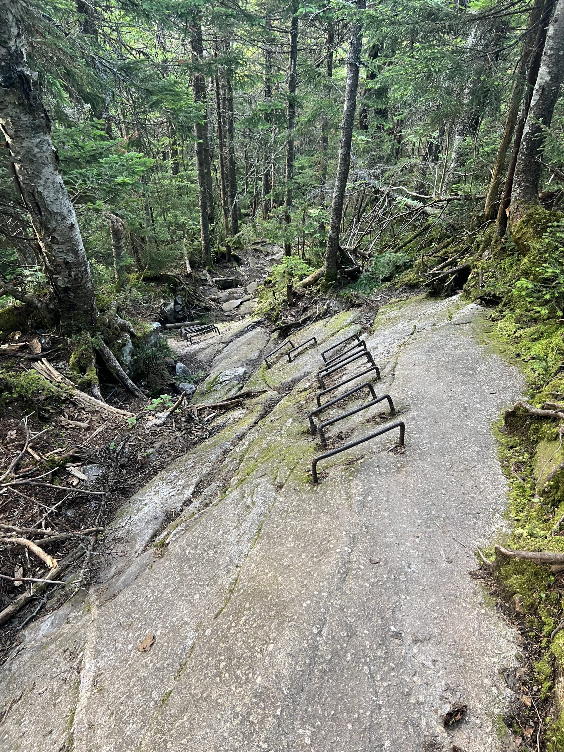
I took some pictures before starting to head uphill again toward the Goose Eye West, East, and North peaks. The peaks were mostly open rock slabs and bog, which provided great views of the area while I walked. The climbs and descents were very tricky during this last part of the day, with multiple rebar ladder climbs and sketchy rock scrambles.

These are more tiring than they look!
I was feeling pretty worn out by the time I made it to Full Goose shelter. I hurriedly made some dinner and set up my gear for the night before settling in.
 ">
">


Comments 5
Congratulations on making it to Maine!
May burritos and bug spray and good tunes keep you going
To Katahdin! Enjoy! Great blog 🙂
I am so excited for you. Somehow your blog appeared on my news feed right at the start of your trip so I’ve been reading along with you. Anyways this totally stranger thinks what you’re doing is amazing and am really proud of you
I had hiked 75 miles of the Presidential Range 45 yrs ago when I was in college. I Love your blog and pictures, brings back great memories I have hiked all over this country and I believe that was the toughest hiking I ever did . Is this the toughest stretch of the AT?? Good Luck Mike Witt
Zazz, great posts! The pictures were super also. I hope you are there by now. Keep on ‘trucking.’ Carey
Congrats! Who needs Katahdin? 2 Chili dogs and Mt Washington. You have achieved nirvana! Embrace it.