Day 140
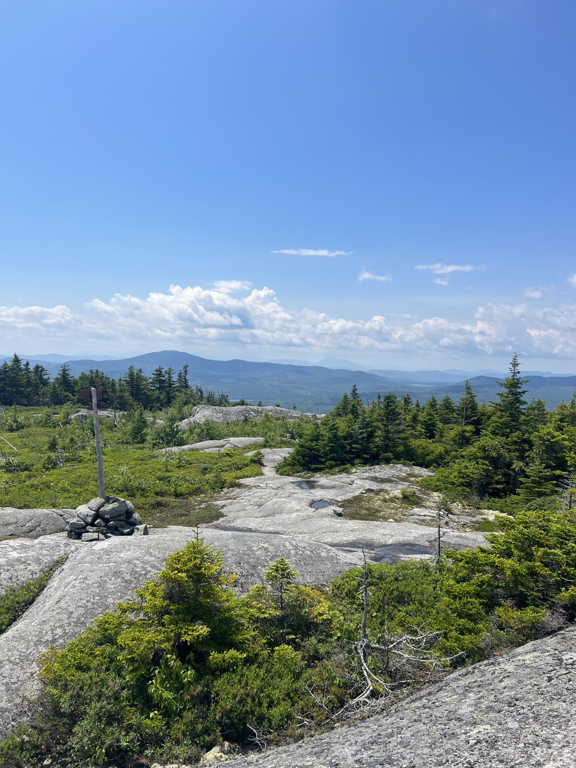
After a hectic morning in the hostel trying to get ready, I was back on trail around 10 and headed toward the Bigelows. Almost immediately after setting off from the parking lot I was swarmed by mosquitoes, and after pausing to put on some bug spray, I tried to push on as quickly as possible. Soon a steady uphill started, and I took it slowly and with many breaks, and after a couple hours I’d tackled most of the climb. After a quick dip to go near Horns pond, the trail started up again toward the South Horn of the Bigelow range. At the top I had great views, I could see behind me back to the ski slopes of Sugarloaf and the ridge to the Crocker Mountains, and ahead to the rest of the Bigelows and the many lakes and ponds below. After I came down from the South Horn the trail led back up the West Peak and then Avery Peak, the last two peaks above four thousand feet until Mount Katahdin.

Looking at Avery Peak and Little Bigelow Mountain behind it from the West Peak
Fortunately, I’d already done most of the elevation gain for the day earlier on, and the climbs up these two peaks weren’t too long or arduous. The huge views continued at the tops of both peaks, and I stopped to look around multiple times as I hiked. On the descent from Avery Peak I felt both excited and relieved, I’d finally finished the large and rugged mountains of southern Maine, and the trail for the next few days was going to be way flatter as it skirted around multiple lakes on its way north. My body was still feeling the effects of the hard terrain from New Hampshire and earlier in Maine, and I was more than ready for a return to some easier hiking. I continued down hill until I got to the Safford Notch campsite around 6 pm, a little earlier than I normally stop, but I was ready to be done and happy to hang around camp and relax a bit. I set up my tent in a nice flat spot and committed to relaxing for the evening.
Day 141
My morning started off with a gradual climb up to the top of Little Bigelow Mountain, which was more of a small rocky hill compared to the peaks the day before. Then began a long downhill which had numerous open rock slab views and wound through mostly pine forests. The morning had started out warm and quickly became hot, and I found myself sweating even during the downhill, which wasn’t pleasant. Once the descent from Little Bigelow ended the trail became mostly flat and passed along the shore of multiple large bodies of water including Flagstaff Lake, West Carry Pond, and East Carry Pond. The trail was still pretty rocky and rooty, but the lack of any real elevation changes meant that I could keep my momentum better than I had on the large mountain climbs. Annoyingly, with the heat and lack of a breeze the mosquitoes and gnats were out in force, and I had to constantly wave away the flies and pick them out of my eyelashes and eyeballs when the waving of my hand wasn’t enough to deter them from dive bombing my face. With the long sections of trail right next to the lake shores I finally got to hear loons calling out on the water, which I’d never gotten to hear in nature before now. As evening approached I found a small tent site next to East Carry Pond and set up my tent before heading to the water where I intended to swim. After looking in the shallows however, I noticed quite a few leeches swimming around so instead I quickly jumped in and hopped back out after washing off the top layer of dirt off my body.

My second least favorite blood suckers on trail
Not quite the relaxing swim I had imagined, but it was enough to cool off a bit. I cooked dinner on the rocks right next to the shore and listened to more loon calls as dusk settled in for the night.
Day 142
The trail looked very flat for the day, so I was excited to get started and cruise along the easy miles. During the morning I got to the Pierce Pond stream, which didn’t have any rocks crossing it, so I had to take off my trail runners and put on my camp shoes and wade across. On the other side I put my trail runners back in and continued down the trail, which stayed next to the cascading stream for miles and I paused to look at the small waterfalls a couple times. The trail sloped slowly downward for a few miles and finally stopped at the Kennebec River.

The wide and deep Kennebec River
Many years ago people used to ford the river, but due to its deep and quickly changing water level from an upstream dam, the ATC now provides an official canoe ferry across the water. I waited along the bank for the ferryman to come across, and then hopped in the canoe and we started paddling across. I was told that the water wasn’t currently very high as we went across, but in the deepest part of the river I would’ve been way over my head and had to swim if the ferry hadn’t been there. I was very glad to stay dry and paddle my way quickly across, then I turned uphill and headed across the nearby road. I was feeling pretty hungry, and thought about trying to go into the nearby town of Caratunk for some real food, but I saw a sign for trail magic in the nearby parking lot, and quickly made my way over. A couple from the Bangor area were out providing a bunch of food for hikers, and they cooked me up a cheeseburger and shared some snacks while I sipped a soda in the lawn chair they had set out. This was super opportune trail magic for me, as I’d been starting to feel pretty tired and hungry but I hadn’t wanted to eat the repetitive trail food I had in my pack. After this great lunch I continued uphill for a few more miles until I reached the Pleasant Pond Lean To. I definitely wanted to snag a spot in the shelter for the night because rain was supposed to roll in, and I was glad to see that there was still plenty of space. After setting out my sleeping gear, I walked to the nearby pond and hopped in for a quick swim, battling the large wind blown waves as the storm started to blow in. I hopped back out and headed back to the shelter for the evening where I relaxed and listened to the rain come down.
Day 143
In the morning it was still raining lightly, but I set off up Pleasant Pond Mountain anyway knowing that it would stop soon. The climb wasn’t too tricky, but on starting the descent I realized that the many roots and lichen covered rocks were way more slick than normal due to the rain, and I tried to carefully make my way off the mountain, but still slipped and fell once. Fortunately, the rain tapered off and the sun came out after a couple hours, and the forest and I started drying out again. After climbing down from Pleasant Pond Mountain, the trail angled up again and started going up Moxie Bald Mountain. This climb was a bit steeper but had some cool rock overhangs, and a wide area at the top was open rock slabs that gave great views of the area. I ate lunch near the top of the mountain, enjoying the strong breeze and sunshine that helped to dry my damp clothes out.

Views from the top of Moxie Bald Mountain
The descent from the mountain was pretty quick and easy, and then the trail started down a slow meandering downward slope following a series of small streams. This section of trail was some of the easiest in a while, even though there were a couple stream crossings without rocks I could hop on, which meant I had to wade through the water. Eventually the little streams turned into a bigger one, a branch of the Piscataquis River, and the trail stuck along its banks for a few miles, which was an unusual and welcome change in the mostly forest scenery. As I went downstream the river cascaded into a narrower rocky canyon, and the banks became a little steeper, with the sound of the splashing water becoming louder as it flowed. I stopped for the night at Horseshoe Canyon Lean To, a shelter just a couple hundred feet above the river, after hiking for almost thirteen hours. I set up my tent, very eager to get away from the flies that had been buzzing around my head all day, and cooked up a tasty Ramen-bomb (a mixture of Ramen and instant mashed potatoes for those of you who don’t remember), before being lulled to sleep by the sound of the river below.
Day 144
I woke up nice and early, excited to only have nine miles between me and Monson. The trail continued along the river as it widened after leaving the canyon for a couple miles before turning up a hill. The Trail remained fairly easy as it went up and over a couple hills and skirted Hebron Lake, and soon enough I could hear traffic and popped out onto the road. A couple who had been doing a day hike in the area offered me a ride into town almost immediately, which I accepted gratefully. My first stop in town was to the Monson General Store, where I bought some pasta salad and normal salad for lunch, before I headed over to Shaw’s Hiker Hostel. Shaw’s is one of the more well known and popular hostels on trail, and has been around for decades, so I was looking forward to staying with them. There were tons of other hikers there, a nice mix of nobos, sobos, and flip floppers, and I even saw a hiker that I hadn’t seen since Glasgow, Virginia. I had a great afternoon chatting with everyone and hanging out, and I especially enjoyed all the fresh food I ate.
Day 145
I spent most of the day hanging around Shaw’s and trying to stay cool during the increasingly hot day. The breakfast services at the hostel was amazing, home fries, eggs, bacon, and blueberry pancakes, and I ate while chatting with a big group of other hikers. I started getting antsy in the afternoon, but finally my family arrived! My dad and brother are going to hike the 100 mile wilderness with me before we all climb Katahdin. The fam grabbed some lunch at the general store before we packed up and headed back to the trail.

This sign makes the trail seem very scenic, but there’s multiple roads going through the wilderness ahead
The trail bounced up and down over a bunch of slate hills with a lot of roots, and we paused at the first shelter to take cover from a thunderstorm that was predicted to roll in. And then we waited. For about two hours we relaxed by the shelter but the storm never rolled in, and when other hikers started showing up who wanted to stay at the shelter overnight we decided to hike on. About fifteen minutes after we started hiking again the storm rolled in, but it was mostly thunder with a few minutes of rain to get us slightly damp but not soaked. We hiked a few more miles until we found a nice place to camp on a spruce covered hillside above Mud Pond (which was a much nicer pond than its name indicates). We set up our sleep stuff and ate dinner on the hillside before calling it a night. Round two of the storm started rolling in as dusk descended, and we fell asleep listening to the rumble of thunder in the distance.
Day 146
The three of us got going into the warm morning around 8 am. Nathaniel hiked ahead of dad and I because he was pretty excited to go swimming at Little Wilson waterfall which was a mile ahead, and when dad and I made it to the falls he was floating on his back above the falls and having a great time. We paused for a bit at the falls to enjoy the view and grab some water before continuing onward. The trail had a lot of ups and downs and was pretty rocky at times, and there were multiple creeks we had to cross, including one without stepping stones which we had to ford. As we were passing a shallow pond Nathaniel commented on the large amount of beaver activity nearby, and as we looked around at all the downed trees Nathaniel spotted a beaver. It was walking along a log at the edge of its dam, and then it walked into the water and swam across the pond, a very cool wildlife sighting. The trail then led up along Big Wilson cliffs, a series of exposed slate ledges with views down toward the pond. The sun was starting to get pretty hot, and we started going pretty slowly up the subsequent hills, which was slightly frustrating. Being so close to the end of this hike and having to slow down felt a little bit like torture, but having family around to hike with makes it worth the slow pace. After eating lunch at a shelter, we continued on, crossing another couple streams, and then walking next to Long Pond stream as it formed Slugundy falls (which is a very fun name for a waterfall). We also passed an arrangement of sticks saying that there were only 100 miles left to Katahdin, its hard to believe that the mileage for this hike is down to just double digits at last!

The last mile marker before the end!
After a brief break at the nearby shelter, we started climbing into the Chairback mountain range. The climb was fairly steep and made me pretty sweaty, but it didn’t require any rock scrambling, and after a couple hours we neared the summit of Barren Mountain. At the top Nathaniel climbed the ladder of the partially dismantled fire tower to get a picture of the view nearby.

Nathaniel taking a picture of dad and I from the fire tower
Feeling pretty tired, we quickly walked the last mile to the Cloud Pond Lean To side trail, and made our way down and around the pond to the shelter. We set up our tents and quickly made dinner before splashing in the pond to clean off some of the accumulated dirt. Then it was off to bed for the evening, having finished a full day of hiking.
Affiliate Disclosure
This website contains affiliate links, which means The Trek may receive a percentage of any product or service you purchase using the links in the articles or advertisements. The buyer pays the same price as they would otherwise, and your purchase helps to support The Trek's ongoing goal to serve you quality backpacking advice and information. Thanks for your support!
To learn more, please visit the About This Site page.
 ">
">


Comments 1
I really enjoy your posts! Congrats…you’re almost there.