 ">
">
Week 22- The Final Week and Summiting Katahdin!
Day 147

The final mile marker before Katahdin!

Reminds me of the Whites
Day 148

Nathaniel on the first steep ascent

Snack time at the summit

An evening at the pond
We had a very peaceful evening watching the sun set and loons swim across the pond as we sat next to the fire, before we settled down for the night.
Day 149
Nathaniel and I woke up next to the pond in a very light drizzle that started and stopped often as we packed up and got ready to head out. We only had seven miles to get to the road where we were going to meet dad and get a ride into town for the night. After tackling the Whitecap range yesterday we’d finished the hard part of the 100 Mile Wilderness, and the miles we had to do for the day were almost completely flat- hooray! We headed down the easy trail, crossing a handful of trickling springs and bog board covered mud pits. The trail was feeling nice and easy, and I was almost surprised when we made it over three miles to the next shelter in only an hour! We admired the falls next to the shelter before heading on.

Cooper Brook falls
The trail led through a quiet forest with large pine trees and glimpses of a lake in the background, which was very pretty to hike through. After just over another hour we popped out onto the road. We’d hiked the seven miles in just over two hours, making our pace around 3 mph, maybe my fastest miles on the whole trail. After waiting for a bit dad zoomed down the road and whisked is off to town for the afternoon. After the previous hot and sweaty days I was more than ready for a shower and a room with a/c for the night.
Day 150
We lazed around Millinocket for the morning before dad, Nathaniel, and I got back on trail in the mid-afternoon. The trail remained super easy with only one small hill to climb over the ten miles we were aiming to do. We walked through open pine forests, around a couple ponds, and crossed numerous wobbly bog bridges spanning a variety of mud, moss, and murky streams. The bogs on trail may not be remarkable to some people, they have no amazing views and often come with more bugs than other areas on trail, but especially in the northernmost states of the trail they’ve been extremely green and mossy, and sometimes almost jungle-like in how thick the vegetation is nearby them.
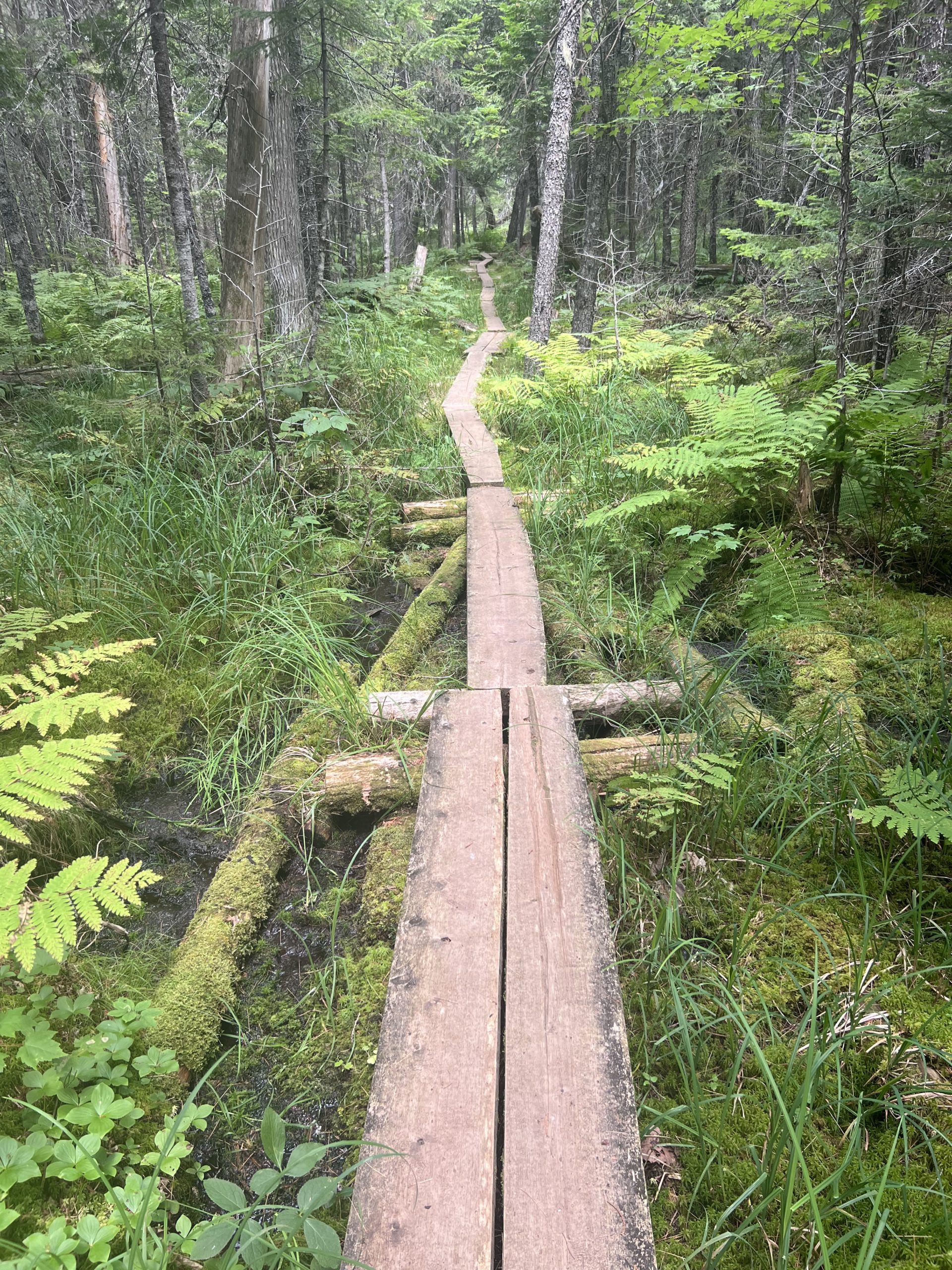
Dad has specifically requested more bog content on the blog, so dad this one’s for you
Next to one pond there was a small sign pointing to a view of Katahdin, which I rushed over to see. My first clear view of the final mountain was impressive. Getting pretty close now
We stopped for the night at the Mahar Landing campsite, which was .2 off trail and didn’t seem very popular from the few FarOut comments I could see about it. The campsite was awesome though, out on a bit of a peninsula so that Pemadumcook Lake was on all sides of us, we had our pick of a large flat area under pine trees to pitch our tents, and a nice fire ring as well. Nathaniel immediately jumped in the lake, after which we cooked some dinner and started a small campfire. Halfway through dinner the urge to swim struck me, so I dropped my pad thai and dove in the lake. The water was clear and quickly got deep as I swam out a hundred feet or so to a rock out in the middle of the water. After a quick cannon ball off the rock, I came back in to dry off and finish my dinner. We sat around the fire as dusk fell before heading into our tents for the night.
Day 151

The view over the lake

Campfire next to Rainbow Lake
Day 152

Wow so majestic

Two stinky guys
Day 153
The overnight rain became a torrential thunderstorm that woke me up around 11pm with its bright flashes of lightning and loud thunder. Nathaniel and I had set up on a wooden tent platform, and despite setting up carefully, with the heavy rain coming down there was a lot of splash back bouncing up off of the hard wooden platform, a lot of which made its way into my tent. That’s how I was woken up again at 2:30am when I rolled over and put my hand in a puddle of water in my tent. So then I had to spend the next fifteen minutes using my pack towel to mop up and ring out the small lake that had accumulated around me, before I went back to sleep again. By the time 5:45 am rolled around I was not very well rested, but ready to get going, and after packing up Nathaniel and I set off to meet mom and dad at the nearby parking lot. Once the whole family was together, we set off up the trail which started out with a fairly easy incline that crossed Katahdin stream and passed a large waterfall. As the trail continued upward it became more rugged, with larger and larger rocks that were closer together, necessitating larger steps and then rock scrambling as we proceeded upward. Eventually dad, Nathaniel, and I forged on without mom (who had decided to do part of the trail and not go all the way up to the peak), and as we passed the treeline the trail became more rock climbing than hiking.
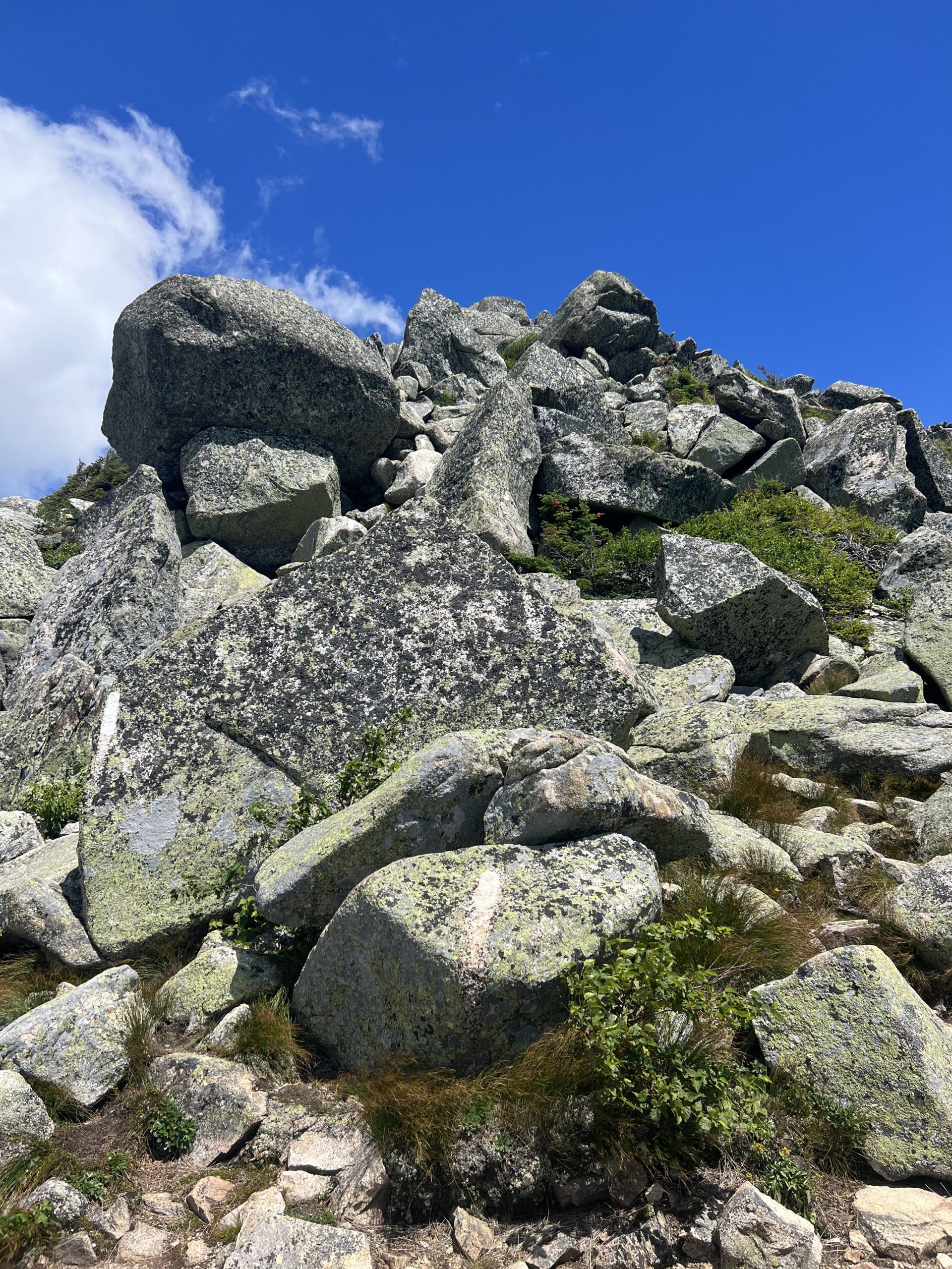
No going around these rocks, the trail goes straight over them
The morning was mostly misty and we climbed up through the dense low hanging clouds, which meant that we didn’t get many views on our way up. The trail continued to get steeper and involve more technical rock climbing as we worked our way up. I think this mountain is definitely the most technical and is in the top five hardest hikes on the whole trail, but the rock climbing was a fun challenge for the three of us. Eventually we popped out on top of the flat tablelands, and got to spend a nice mile picking our way through smaller rocks along the level plateau.

Nathaniel strolling across the Tablelands
The clouds were slowly breaking up as we climbed up the final ridge, and we enjoyed watching them across the rides and break into pretty shapes as they were blown against the rocks. Finally through a break in the clouds we spotted the summit and the iconic sign ahead of us, and we quickly hiked the last few feet to the summit and touched the sign. The winds were pretty strong and with the cloud cover we were chilled quickly, so we took some cover behind a pile of rocks to eat lunch. While we ate we watched the clouds streak by and enjoyed the views.

The view of the Knife’s Edge ridge and the valley below
After lunch and when the clouds had cleared a bit more, we stepped over to the sign to take our photos.

My picture at the summit
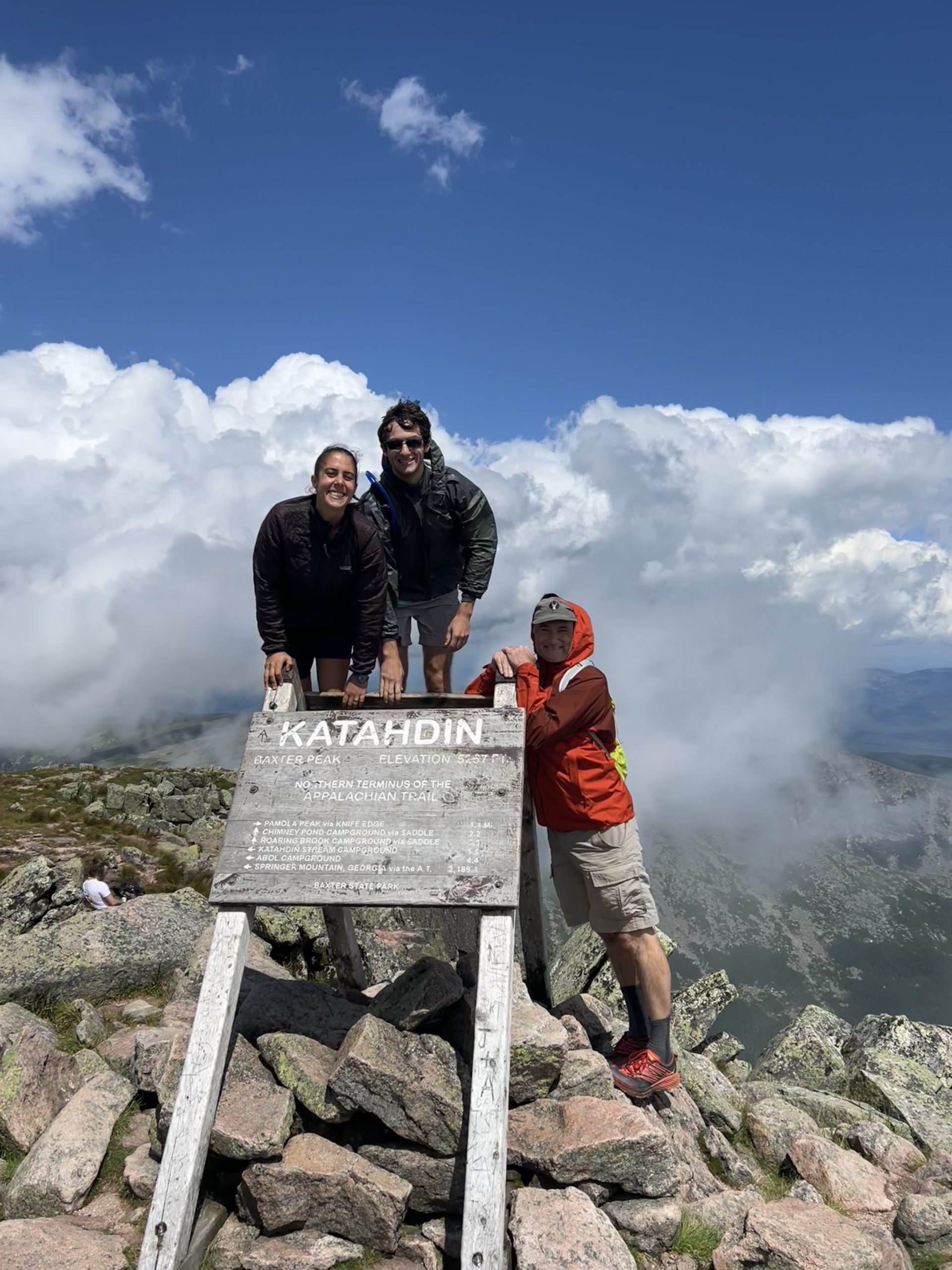
All three of us at the summit sign
Then we started heading back down. I’d officially walked from Springer Mountain, GA to Mount Katahdin, ME and finished the trail, all that was left was to hike off the mountain. The clouds kept clearing up as we made our way back across the Tablelands and started down the steep rock climbs. Maybe it was good that we hadn’t been able to see too far up the trail on the way up, because the view down the ridge was steep and intimidating.

A very sheer drop on either side of the trail along the ridge
The climb down all the boulders didn’t go much faster than the climb up them, and I started feeling tired as we clambered our way down. Slowly the trail started getting easier again, and I was very glad once we crossed Katahdin Stream again and had all of the rocks and elevation behind me. We made it back to the parking lot about eight hours after we’d started in the morning, and met up with mom again (who had enjoyed her hiking too). Then we hopped in the car and rode back to town for showers and a delicious fish fry dinner.
Well there’s my thru hike, 2194.3 miles in five months and three days. It was a lot of walking, a lot of cold, hot, bugs, and uphills. I really enjoyed pushing myself and spending so much time experiencing the diversity of nature along the Appalachians. Now I think I’ll go lie down for a week straight. I hope you enjoyed reading my posts, I read and appreciated every comment even if I didn’t get to reply to them all (except for Sue’s ?). I’m hoping I make one more post-hike gear review and some hike statistics post in a couple weeks, so if you’re interested in that technical stuff then stay tuned, and if not then thanks for reading!

This website contains affiliate links, which means The Trek may receive a percentage of any product or service you purchase using the links in the articles or advertisements. The buyer pays the same price as they would otherwise, and your purchase helps to support The Trek's ongoing goal to serve you quality backpacking advice and information. Thanks for your support!
To learn more, please visit the About This Site page.

Comments 13
Congratulations Miranda !
I have enjoyed reading your blog .
Way to go completing the AT Trail !
Congratulations Miranda!! Been following you since Georgia. I live right off the AT in Hampton Tennessee. You did GREAT, so happy to see this accomplishment made by a woman!
Hi Miranda. I have really enjoyed and looked forward to reading each of your posts. You have accomplished a wonderful thing and you should be so proud of yourself. I wish you the best of luck in all of your future endeavors!
Congrats…job well done. I haven’t been following your blog but after reading your last 2 posts, I plan on going back to your 1st and reading through.
Great job and good luck to your future ?
Zazz, thank you so much for sharing your hike! I am 66, did most of the Trail when 63 and 65, including Mama K. But I still have most of MA and up to Caratunk ME to go, hoping next year. Your matter of fact love for the Trail, and your description of each day and week thereon, have helped me as I wait at home this year! Again: thank you so much! Enjoy what comes next. -Sky Pilot
Congratulations Miranda that is a great feat you accomplished!!! You should be so proud of yourself. I have been following you since the start, and looked forward to your posts every Sunday while I drink my morning coffee. So glad you were able to share your journey with all of us!!!
Thank you!!!
Congratulations, Miranda! How exciting for you!! You did it!
Congrats. Epiphanies or not you did great, those may come in the future. Good luck in the future and they were great pics. Your Dad was right about the bog pics.
Cheers!
Congratulations Miranda! I have been following your posts from the beginning of your journey. My daughter had friends who hiked the trail a few years ago. We picked them up near where we live in Front Royal, VA and provided showers, a bed, and stuffed them as much as we could. Ever since then, I pick a couple of people to follow on the blog. You are a great writer and I have enjoyed following your journey!
Congratulations on your thru hike! It’s been very enjoyable keeping up with your progress the last 5 months. Thanks for all your posts.
Congratulations! I enjoyed keeping up with your hike. I thru hiked in 2021, so it was fun to relive many of the things you described.
Congratulations on your great accomplishment. I enjoyed following you to the end.
Congratulations! Enjoyed following along.