 ">
">
Why Didn’t Anyone Tell Me About This?! The 5 Hardest Sections of the AT No One Talks About
No one starts the AT thinking it’s going to be easy. The moment someone vocalizes wanting to thru-hike, they are likely to be met by naysayers and people concerned with the challenges hikers face. The famous Appalachian Trail Conservancy statistic is thrown around: “Each year, thousands of hikers attempt a thru-hike; only about one in four makes it all the way.”
When I decided I was going to hike the AT in 2021, I, like many, started doing some research. I read numerous books detailing others’ thru-hikes and watched countless vlogs. My hope in consuming copious amounts of trail content was to better prepare myself for the hardships to come.

Baldpate Mountain in southern Maine on a clear day. Photo courtesy of Kayla “Bug Bite” Measell.
From the beginning, no matter what the source materials may be, there are certain sections of trail that are infamous for their difficulty. Everyone talks about how hard the Whites in New Hampshire are, the crazy elevation gain going northbound out of the Nantahala Outdoor Center, and the four points of contact required in the Mahoosuc Notch.
Read next: The Hardest Sections on the Appalachian Trail
During my NoBo thru-hike, I found that, yes, those sections were tough, but they didn’t surprise me. Because of the hype and fearmongering, I felt mentally prepared to “embrace the suck.”
It was the little-discussed sections of trail that really pushed my limits and made me question why I was attempting to thru-hike. There were plenty of times I found myself thinking, “why didn’t anyone warn me about this?!”
The 5 Hardest Sections of the AT No One Talks About

Drew “Dumb Horse” Darley scaling a rebar ladder. Photo courtesy of Erika “Creature” Novak.
In order to impart my hard-earned knowledge to future thru-hikers, here’s a list of the five hardest sections on the AT no one talks about.
1. The Wildcats
According to FarOut, Pinkham Notch Visitors Center is at NoBo mile 1873.7 and sits at an elevation of 2029′. 21.1 miles later, US Route 2 sits at 768′ in elevation and is a straight shot into Gorham, NH with hostels and restaurants galore. Between these two roads, the Wildcats ascend 6,751.3′ and descend 8,009.2. That’s an elevation change of 700.5 ft/mi! My knees still hurt just thinking about it.
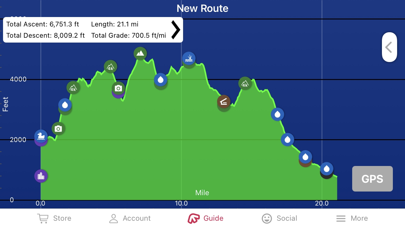
Screenshot of the elevation profile of the Wildcats on FarOut. Pinkham Notch Visitors Center to US Route 2. Total grade: 700.5 ft/mi.
There are multiple peaks a hiker must bag in order to make it through the Wildcats. Wildcat D Peak, Wildcat Mountain, Carter Dome, South Carter, North Carter Mountain, and Mt. Moriah are all over 4,000′ in elevation.
One of the reasons I thought the Wildcats were so hard was because my tramily decided to slackpack the entire 21.1 miles section from Pinkham Notch to Route 2 in one day. We stayed at The Barn Hostel in Gorham, NH and the owners offered a sweet deal on slackpacking. At that point in our hike we were desperate to finish the Whites, so an all-day suffer-fest felt like an appropriate way to bid farewell to the Whites, even if it meant big miles during a thunderstorm.
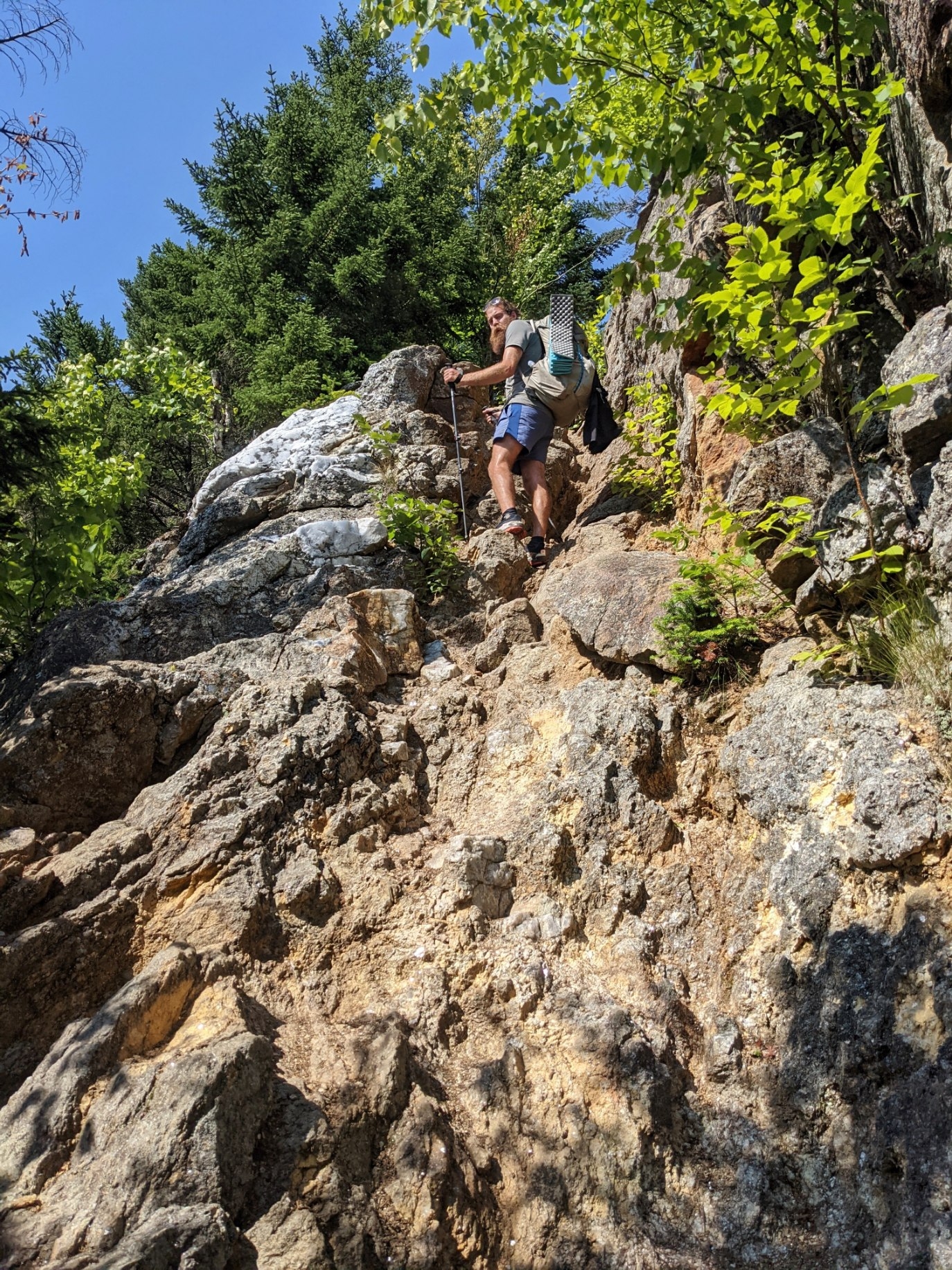
Drew “Dumb Horse” Darley scrambling up rocks in the Wildcats. Photo courtesy of Erika “Creature” Novak.
The only warning I received about the Wildcats came during trail magic graciously provided by the Appalachian Long Distance Hikers Association (ALDHA). My tramily and I were fortunate enough to stumble upon the ALDHA campsite in Gifford Woods State Park campground just after Killington, VT.
I vividly remember one of the trail angels telling us about the Wildcats because he said it was the section of trail responsible for the most broken bones. After sliding down rock slabs in the rain and stumbling through boulder fields in my quest for US Route 2, I didn’t doubt this statistic at all.
My biggest advice for tackling this section of trail is to mentally break it down into different checkpoints. When looking at the elevation profile for this entire stretch, it’s easy to get overwhelmed. Take it one peak at a time. First, climb up Wildcat D Peak and take a break on the chairlift.
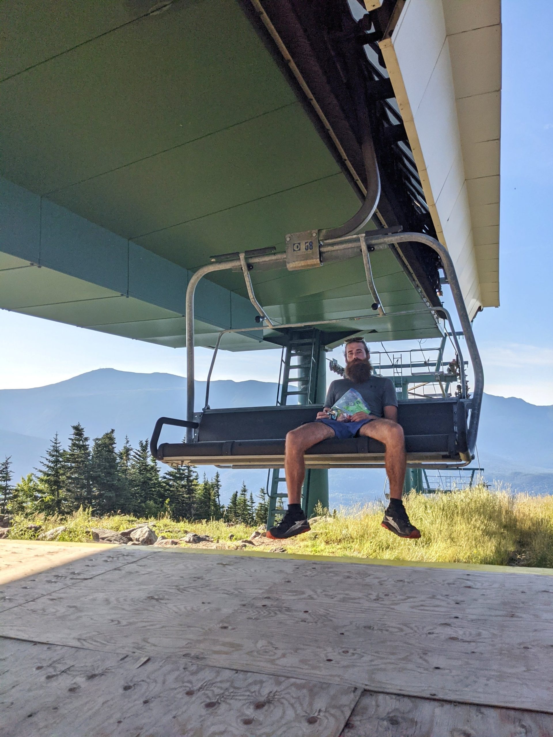
Drew “Dumb Horse” Darley enjoying a break on the Wildcat chairlift. Photo courtesy of Erika “Creature” Novak.
Next, push yourself to Carter Notch Hut and use your last AMC thru-hiker voucher freebie. If you’re not doing the Wildcats in one go, Imp Shelter is a great stopping place for the day or a wonderful snack spot if you’re going to push to US Route 2. The last big push is Mt. Moriah; it’s all downhill from there.
2. Southern Maine
Getting into Maine felt like such a big deal. I had walked through 13 states and was in the final arena. Katahdin felt so close as I stood posing for photos by the last sign marking the state line, but little did I know that southern Maine would absolutely kick my butt.

Cade “Truffles” Smith and Anna “Magic” McKinney are all smiles to have walked to Maine. Photo courtesy of Caleb “Hangman” Smith.
The end of New Hampshire meant the end of the Whites, and I thought that meant the end of difficult miles. WRONG! No one ever told me that southern Maine would be some of the toughest earned miles. Between the bog boards, torrential downpours, never-ending sheer rock face climbs, and rebar ladders, southern Maine felt like it was the AT’s final attempt to prevent thru-hikers from reaching Katahdin.
There are specific mountains/areas that still haunt me to this day. Everyone has heard about the “hardest mile on the AT,” the Mahoosuc Notch. The Notch gets so much attention that most people forget to mention the following 1,600+’ ascent over 1.5 miles up Mahoosuc Arm. In my memory, this was basically just a rock slab that I had little energy left to scurry up after the Notch.
There were few moments on trail I actually feared for my safety, but going over west and east Baldpate peaks, I felt as though I might fall off the side of the mountain. This fear was perpetuated by the fact that it was raining, windy, and the fog was so thick I could hardly see ten feet in front of me. I had never heard of Baldpate before my near emotional breakdown atop the peak.

The Angry Women tramily enjoying the view atop Baldpate Mountain. Photo courtesy of Kayla “Bug Bite” Measell.
Another triple threat in southern Maine is the steep ups and downs going over Saddleback Mountain, the Horn, and Saddleback Junior around NoBo mile 1980. Again, this was a range I had the misfortune of traversing in sleet/rain at the end of a long day. In reference to this section, my trail journal from that day said, “per FarOut, it looked like the rest of the day would be straight uphill, so I was feeling anxious and unable to hike… We even went above treeline again for Saddleback Mountain and the Horn but didn’t get any views because we were socked in.”
The trail’s last attempt to stick it to hikers is the Bigelows. My trail journal from that day read: “These were the last 4000 footers before Katahdin, so getting over these felt like a huge accomplishment. The climbs were long and steep in sections but not any worse than other hills we’ve scaled.”

There’s a trail there? SoBo rocks in southern Maine. Photo courtesy of Tyler “Gearz” Roberts.
So how does one survive the final miles in southern Maine? Don’t lose sight of the goal. By the time a NoBo hiker crosses into Maine, they have less than 300 miles until they have completed the AT. Quitting so close to the finish line would be almost as challenging as walking from Georgia to Maine!
3. The Kinsmans in NH
Screenshot of the elevation profile of the Kinsmans on FarOut. Eliza Brook Shelter to Lonesome Lake Hut. Total grade is 705.2 ft/mi over 5.9 mi.
My trail journal from the day I climbed the South and North Kinsman mountain goes as follows: “It felt like the trail was climbing straight up the mountain; lots of boulders to climb over. It wasn’t too bad, and there was a really pretty bog about 1.5 miles from the Kinsmans, but it looked right up to the summit and was crazy intimidating. The climb up was the toughest yet—so much vertical climbing that required me to use my hands in order to pull/push myself up. It felt like it took hours, and I was cranky and exhausted by the time I got to the top.”

Anna “Magic” McKinney is less than excited about the final push to the top of South Kinsman (the peak she’s pointing to far off in the distance). Photo courtesy of Joshua “Gooey” Kay.
In just under 2.5 miles, a NoBo hiker must climb almost 2,000 feet of elevation from the Eliza Brook shelter to the top of South Kinsman Mountain in New Hampshire. I remember distinctly hiking alone up this mountain and wanting to take a break to cry. Not to rest, but literally to sit down and cry because I was having such a hard time.
Maybe I was just having a really, really bad day, but either way going up the Kinsmans in the Whites sucks. I am proud to say I did not let myself stop climbing to have a pity party and instead kept pushing to the summit.

Bog boards near the alpine bog below South Kinsman peak. Photo courtesy of Kayla “Bug Bite” Measell.
Sometimes it is necessary to give yourself a break in order to compose yourself when the mental climb is just as challenging as the physical climb. On the flip side, sometimes it’s necessary to push through the pain and not rest until you have done what you set out to do. In the words of my middle school gym teacher, “suck it up, buttercup.”
4. Jacob’s Ladder
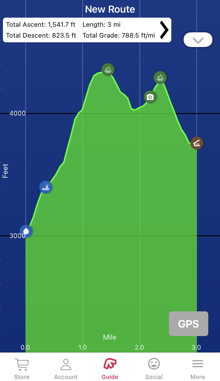
Just after the famous climb out of the Nahahala Outdoor Center in North Carolina, there is an equally intimidating climb with less infamy. “Jacob’s Ladder” starts close to Stecoah Gap at the base of Sweetwater Gap, 2021 AT Guide NoBo mile 151.5. In just 0.6 miles, the trail climbs 600 feet to the top of a “cliff.” That’s 100 feet per tenth of a mile! So early on in the trail, this equals out to be a ball buster.

Screenshot of the elevation profile of Jacob’s Ladder on FarOut. Sweetwater Gap to Brown Fork Gap Shelter. Total ascent: 752.6’, total descent: 275.9’. Length: 1.4 mi, total grade: 757.3 ft/mi.
Before I arrived at Stecoah Gap, I had never heard of Jacob’s Ladder. It was a wary trail angel who warned me about the steep climb. Thankfully, though, I remember this section of trail having tons of switchbacks. I am a big fan of taking breaks, especially during a climb, and the switchbacks offered plenty of opportunities to rest. I especially like to face downhill when I am resting so that I can see how far I have already come rather than staring at the looming accent.
My advice on an aggressive climb like this one is to pace yourself. You aren’t going to win a medal at the end for being the first one of your friends to reach the top. Why overexert yourself when you could take your time, practice controlled breathing, and actually enjoy your hike?
5. The climb into NC
Being a North Carolina native, I was thrilled to have crossed the line from Georiga into the old north state at mile 78. My friends and I took pictures at the state line and even had a photoshoot by an iconic tree at Bly Gap.

Bug Bite posing by the tree in Bly Gap before embarking on one of the hardest, yet still under-hyped, sections of the AT. Photo courtesy of Kayla “Bug Bite” Measell.
The trail climbs sharply out of Bly Gap and continues steeply traversing up and down until finally arriving at Muskrat Creek shelter approximately three miles away. My trail journal detailing this climb said, “the majority of the day was manageable, but the first three miles of NC were BRUTAL! … I didn’t think we’d ever make it to the shelter, but we finally arrived.”
The excitement of the first state line crossing was a sharp contrast to the pain I remember experiencing chugging up this section of trail. I remember passing other hikers and, in turn, being passed. This climb felt like it went on forever. Finally arriving at the shelter to drop my pack and kick my feet up felt like heaven on earth. With so few miles on my trial legs at that point in my journey to Maine, this climb stuck out as especially challenging.
My best advice for pushing through the climb into North Carolina is to tackle it with a buddy. On this day especially, I am thankful to have hiked with my friend Bug Bite. Having someone else to talk to and suffer with somehow eases the tension and lets your mind focus on making conversation rather than your heaving breath and aching muscles. This section of trail also has some nice lookout points, so take plenty of breaks to enjoy the view and catch your breath.

Anna “Magic” McKinney giving the climb into NC a thumbs up. Photo courtesy of Kayla “Bug Bite” Measell.
Miley Cyrus Said It Best
No matter how challenging a section of trail is, it will inevitably end. There were days during my thru hike I thought I would surely keel over and die on the spot, but all the pain, suffering, and agony faded away each night when I crawled into my tent. They say all good things must end, and the same is true of the bad things as well. Most days, I would give anything to be back on trail, even if it means dry heaving at the top of a mountain or sliding my way down a rock face.
“Ain’t about how fast I get there/
Ain’t about what’s waiting on the other side/
It’s the climb.”
No matter how difficult or impossible parts of the AT may feel, thousands of people successfully thru-hike every year. Why shouldn’t you be one of them?

This website contains affiliate links, which means The Trek may receive a percentage of any product or service you purchase using the links in the articles or advertisements. The buyer pays the same price as they would otherwise, and your purchase helps to support The Trek's ongoing goal to serve you quality backpacking advice and information. Thanks for your support!
To learn more, please visit the About This Site page.

Comments 22
Good article Magic! I liked this one a lot.
Seriously, please stop calling western Maine “southern Maine.” The trail does not enter York or Cumberland counties, regardless of what non-Mainers think, the trail enters from western Maine. I was born and raised in Maine and whenever a thru-hiker spoke of southern Maine I assumed they went down to Kittery for shopping. As a former thru-hiker, I cringed EVERY TIME I heard another hiker call it “southern Maine.” Please, start acknowledging that the trail goes through the a far less populated part of the state.
People are not referring to the state as a whole it wouldn’t matter if you entered the state from the east or the west it is still southern Maine by the trail specifically which predominantly follows a north south heading and when heading NOBO you are entering the southern most portion of the state the trail traverses
Or good old Mt. Americus, just off the Pike and Rt 1.
Obviously you didn’t attend the Appalachian Trail Institute where we cover all these sections (and their inherent difficulty).
Pound for pound, ATI graduates are among the least ‘naive’ thru-hike dreamers that start.
Very condescending, not sure I would be interested in learning from someone with this attitude. Everyone faces their own challenges on the trail and I admire Magic’s ability to offer honesty, insight, and a healthy perspective into some of the unexpected challenges of the AT. She hiked the 2,200 miles herself and thankfully doesn’t need your validation or opinion.
Congratulations Magic on a huge achievement and a great article!
This comment feels very elitist. Aspiring thru hikers take many different paths in approaching their thru hikes and not everyone has the ability, time, or means to attend an official AT institute before the trail.
I am grateful that different free resources exist for folks of all different backgrounds and experiences to attempt the trail and experience the outdoors.
Magic, congratulations on finishing the trail and pushing through any unexpected challenges that may have arose for you along the way! That’s part of the joy and reward of hiking the trail, right? Taking each day, one at a time, and rising to the challenge.
Nothing condescending or elitist in Warren’s comment…thin-skinned thru-hikers beware
Nothing to see here, folks. Move along…
Yup typical thought process of Warren’s his way is the only way to hike the trail if you didn’t do it his way you didn’t do it at all and the only people who ever finish were coached by this elitists schmuck
As a former thru hiker… “Hike Your Own Hike.” I applaud Magic for this article and can say she is spot on.. the climb into NC is no joke, especially early. Plus Jacob’s ladder is tough. My most difficult day was The boulder field going into PA… not sure why, but my knees hurt afterward.
Ah… great memories! You are correct on all 5 counts. Thanks for posting. I remember the climb to Cheoah Bald was a ball buster too.
Difficulty is a bit about the trail, but a lot about the weather, and mostly about you. When I got to the Whites I was flying along. Late September, frost forming on my jacket as I hiked up Mt. Washington, twenty mile days, no problem! A few days before, struggling up Kinsman in the rain, no room at the shelter, getting dark. Twenty years later, with my 12 year old, bracing for Kinsman, but flew up, left me wondering why the part I remembered never came. Mt. Washington- blasted off the trail by wind, a struggle all day. My guess is that those spots where you have to tell yourself that if other people can get by, you can too, some of those spots are shared, and some of them are yours alone.
The black flies & mosquitoes in Maine in June were by far the hardest part of this SOBO hikers little 1996 adventure. Great article- thanks.
I see that ECU shirt! Go pirates!
–Dirty Rotten Liar, AT c/o 2015, ECU c/o 2010
Baldpate in the rain is No Joke!
One thing I discovered going SOBO was that a number of the NOBOs I met had skipped the Wildcats and were going to do them later.
You were spot on about the mountains in Maine.
Because of a shift in the weather, coming out of the NOC we did the climb and Jacobs Ladder in the same day. But a ridge runner amended our reservations so all was good.
I was happy to see in all the pictures, the hikers carrying their own full packs up these sections- so many people wimp out and slack pack these sections now.
Great observations and comments. My son “Just Pete” and I NOBO through-hiked in 2015. Started in Late February following a week of temperatures that dropped into single digits, followed by freezing rain. Oddly for us one of the hardest/worst days on the trail was day one going from the southern terminus on Springer down to the National Forest Springer Mountain parking lot. After the freezing rain it had snowed and we couldn’t find hardly any of the white blazes because at the top they were on rocks buried under the snow. When we finally found the trail and headed downhill we discovered that the trail was in reality just a Luge run – a narrow, U-shaped, ice-covered track going downhill and covered a layer of snow. We probably each fell 20-30 times before we got to the bottom. When we finally arrived at the parking lot the sun had started to peak through and the ice sheet was starting to melt just enough to make it even slicker. I was literally on my hands and knees with my pack on my back crawling across the parking lot. We had tried to buy a couple pairs of Yaktrax to strap on our boots while we were in Asheville the day before we headed down to Amicalola, but every outfitter in Asheville was sold out. They told us that earlier in the week the local fire departments were buying them all because when they were trying to hold their fire hoses and the water dripped down by their feet it froze and the firefighters couldn’t even stand up. After that start we always had something to look back on and say, “At least we’re not trying to hike down a Luge track!”
Add the descent from Mount Garfield, down to Gail head hut in the White Mountains. For that matter, add anything downhill in the Whites!