 ">
">
Week 3 Update: Winter on the Wall
Writing from the comfort of Hot Springs, North Carolina, it’s hard to believe that a few days ago I was shivering on a mountaintop with wind whipping in my face. The trail feels different on the other side of the Smokies. People are walking longer days, and talking less about town. I suppose we’re all ‘finding our trail legs’, so to speak. We’ve come almost 300 miles and passed our first big challenge along the way.
So, where have I been since my last update? Here’s the short version:
- NOC to Fontana Dam, 28.0 miles: 2 days
- Smoky Mountain crossing, 75.6 miles: 4 days
- Standing Bear Farm to Hot Springs, 33.4 miles: 2 days
Now I’ll go through the long version and say a little more about the Smokies while I’m at it.
Days 12-13: Out of the Nantahala
‘Hike Your Own Hike’

Ramps! A special treat along the trail, if you know where to look.
Climbing up from the Nantahala River, I was walking mostly alone. I crossed paths on Cheoah Bald with a Canadian couple who was doing the trail like I am — quiet and solitary, focusing on nature. Since then I’ve realized there are a lot of us out there, we’re just not very noticeable on the trail. Just like in the rest of the world, the people who gather together and make themselves seen are most conspicuous and set the tone. A lot of them make great company, but I shouldn’t feel like I’m doing the trail wrong if I do it a different way. I’m ‘hiking my own hike,’ after all. For me, that means starting before dawn, skipping shelters, and only stopping by to say hi every now and then.
A Fontana Interlude
After Cheoah Bald, the trail dives down to Stecoah Gap and then runs the long ridge between there and the Little Tennessee river crossing at Fontana Dam. It climbs every knob and knoll along the way, making for a roller coaster of a hike. On Saturday afternoon I finally made it to the shore of Fontana Lake. As I stood there wondering how I would go the two miles to the lodge, the resort’s shuttle van pulled up. Next thing I know, I’m getting the full tour of the area and being dropped off in a palatial hotel lobby, with a crackling oil fireplace and a well-stocked resupply.
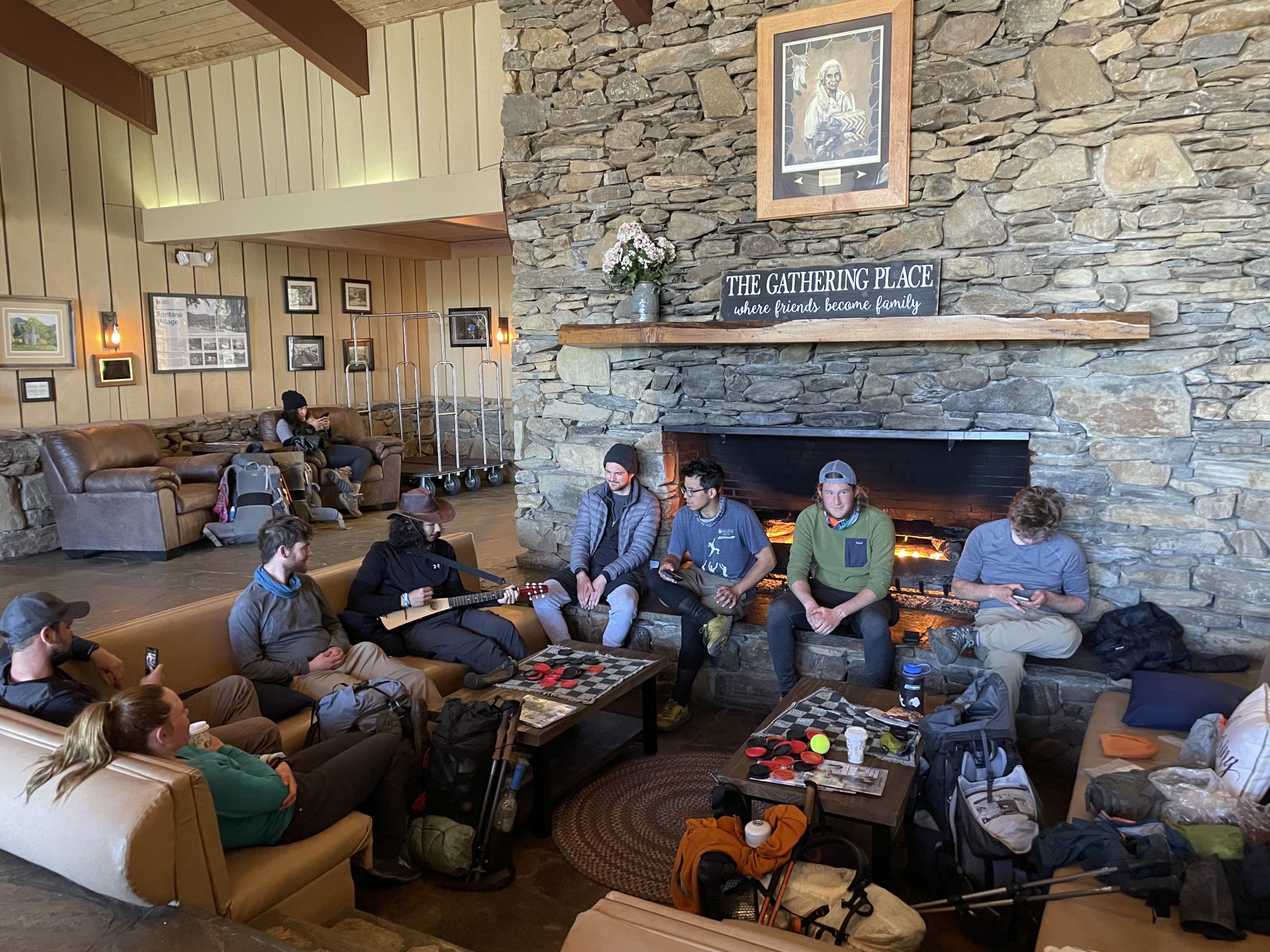
Hikers hanging out at the Fontana Lodge.
I reconnected with some familiar faces at the lodge, including Goodall from Massachusetts, who I’d met on the approach trail back on day one. We’ve been crossing paths pretty often since then, though she’s definitely faster hour for hour, and I’ve been joking that I might end up as ‘trail cousins’ with her tramily if we keep this up. (Tramily = ‘trail family’, for those who don’t know.) There was also a wedding at the resort, which made for a pretty amusing atmosphere — us hikers huddling around the fire and hoarding muffins while the wedding guests filtered in, dressed to the hilt. On my way out, I explained to a few of them why there were so many hikers at the lodge. They had no idea we were all walking to Maine!

The Fontana Hilton.
I’d meant to enter the Smokies that evening, but then I saw the shelter they call the ‘Fontana Hilton’. It has hot showers! A phone charging station! A whole campground around it with concrete tent pads! So I set up camp in the sunny afternoon and decided to start my Smokies journey with a night walk.
Days 14-17: The Frozen Heights
Welcome to Winter

Entering the smokies in the dead of night.
I woke up in the middle of the night and quietly packed up, then started my road walk to the dam. The stars were bright, and Orion was just setting in the west as I set out. The dam was eerie at 4 am, a huge wall of concrete studded with harsh electric lights. An enormous flag waved overhead in the artificial glare. The dark settled in on the other side as I turned up a steep hill towards the ridge. The hooked tail of Scorpio filled the southern sky. Towards dawn a yellow crescent moon appeared, flanked by glowing planets. The wind picked up. As the sun rose I sat on a log off-trail and made some breakfast.
Once I reached the ridge, the first thing I saw was a shelter, with a single tent pitched nearby. A figure slowly emerged from the tent, bundled up so tightly that you could only see its eyes. I later learned it had dropped into the teens that night, the worst cold snap in weeks. The bundled-up guy was named Nosebleed, and we crossed paths a lot over the next few days.
In the Smokies you have to go shelter to shelter, so I met more people than I had before along the trail. They were all grim, hardy, and weather-beaten. You have to be to walk all day in a blustery 25 degrees. For the next two days, the main thing on my mind was how to keep things from freezing. Winter was here.

Tired, cold, but happy on the summit of Rocky Top. Photo by Nosebleed.
Above the Clouds
I walked 24 miles that day and settled down for the night at Derrick Knob Shelter. The next day I climbed through yellow birch into the spruce-fir forest, a little slice of New England in the South. I saw red squirrels for the first time near Clingmans Dome (or Kuwahi, ‘mulberry place,’ in Cherokee). Peat moss and lichen carpet the forest floor, while the Northern scent of Christmas trees fills the air. I summited Kuwahi on the afternoon of the second day and climbed the deserted watchtower alone. At 6643 ft, it’s the highest point on the trail, and one of the highest peaks in the whole Appalachian range. It’s all downhill from there.
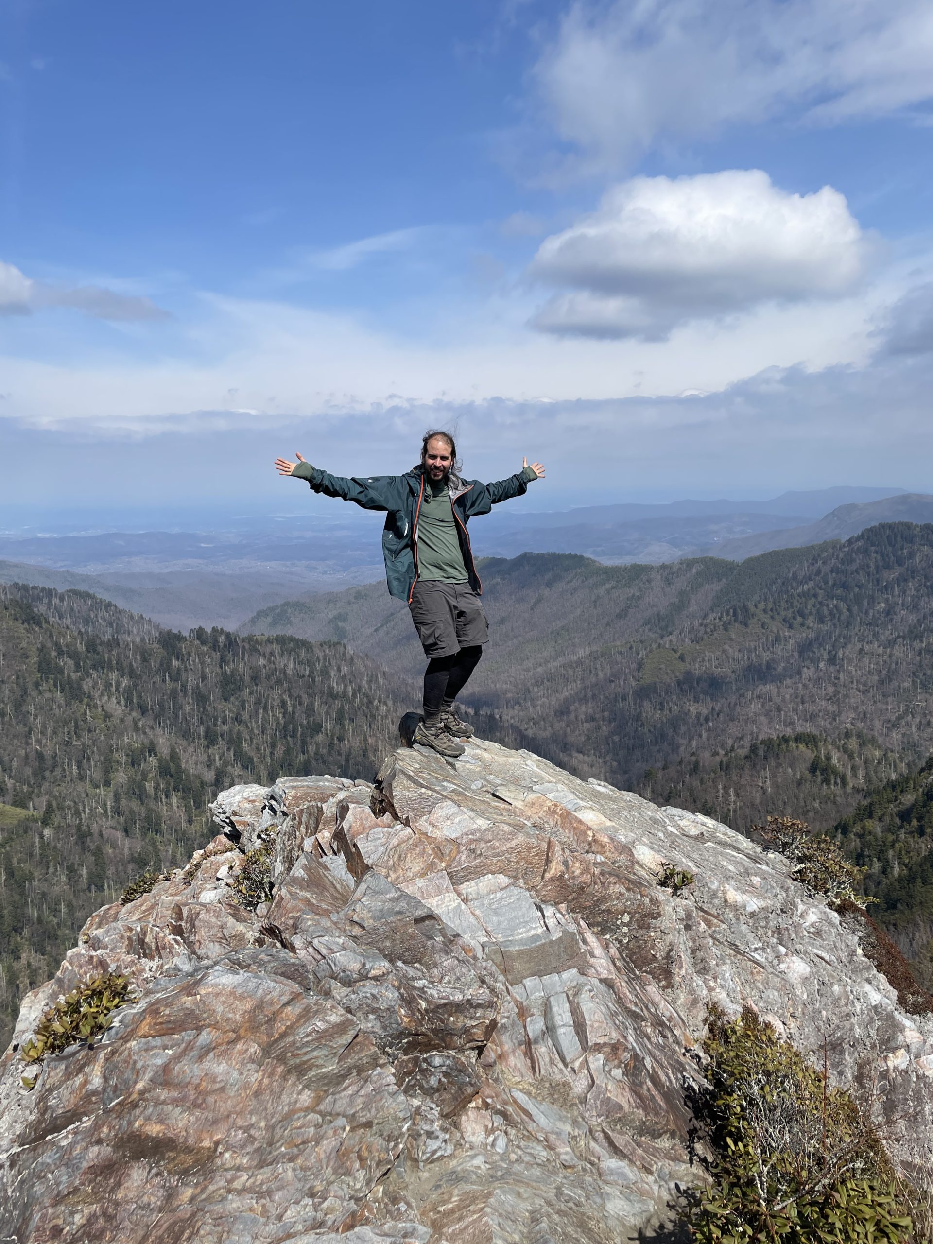
I took a climb on the Bunion.
The next morning I sped past Newfound Gap, and by noon I was enjoying the spectacular views from Charlie’s Bunion. I was a bit of a tourist attraction there for a college group from Ohio on spring break. They loved the idea of a thru-hiker walking two thousand miles to Maine. After my second 20-mile day on the trail, I stopped at the Tricorner shelter for the night.
The temperature finally climbed into the 50s that day, and the wind died down. By the time I dropped to 4,000 feet, it almost felt like spring again. Before I knew it, I was crossing beneath an interstate highway and over the Pigeon River. I had left the Great Smoky Mountains National Park behind.
Days 18-19: North of the Wall
At the Standing Bear
The night I left the Smokies, I stayed in a bunk at Standing Bear Farm, hoping for a little rest and respite from the rain. Standing Bear is a wild little place, a compound cobbled together as a way station for weary hikers. It’s the only place I’ve ever used a washboard to do my laundry, or slept on a bed made out of unfinished logs. One comment on FarOut said it had ‘hippie/hillbilly vibes’; my take is that it feels like what would happen if the Trail itself grew a hostel.

The washing machine at Standing Bear Farm.
There was a vicious wind in the night. The door to the bunkhouse kept blowing open, and two trees crashed down outside. I left before dawn as usual and climbed on out of the river valley. The mountains in this section are mostly ‘bald’ on top, with grassy clearings covering the peaks. First I reached Snowbird Mountain and then Max Patch, which had the best 360 view I’ve seen so far. Ragged clouds covered the ridge of the Smokies to the south, and the high peak of Mt Mitchell (Attakulla) rose to the northeast. That evening I camped 19 miles down the ridge, in a hollow filled with flowing springs.
Climbing Down into Town

Appalachian vibes at Hot Springs, NC.
Yesterday was harder than I expected. There was still one big peak to climb before the ten-mile descent to Hot Springs and the French Broad River. I trudged into town at one p.m., with a reservation at Elmer’s Sunnybank Inn. It’s a vintage bed and breakfast in the oldest home in town, a creaky old mansion that both sides used as a hospital during the Civil War. Elmer is a retired academic who’s been running the place for years. He keeps a massive library of books on local history and Buddhism in a room upstairs. I’m staying in the old servant quarters behind the porch and reading up on Bartram and some Cherokee lore.

Words to help you hunt deer, fall in love, cure the chills — it’s all here in Mooney’s book, thanks to the Cherokee elder Swimmer. My favorite is the song of the bears up in the high Smokies.
Postscript: Whose Smokies are they?
The ‘right answer’ to this question is, of course, the Cherokee. They were needlessly evicted during the 1830s gold rush, and the land was since depopulated and passed into Federal hands. But given that the high wall of the Smoky Mountains is a national park, for whose benefit is the park maintained? What’s the role of the thru-hiker in this place?
Hiker Trash in the Park
This question is worth asking because the park administration seems to have decided that thru-hikers are a nuisance, while day users and vacationers are the intended guests. The restrictive regulations within the park are intended to promote conservation and minimize human impact, and this is a worthy goal. If these measures were presented respectfully and equitably towards all parties involved, I would have no issue with them. Behavior like littering the woods with unburied toilet paper, or hacking limbs off of live trees for firewood, is inexcusable and should be dealt with severely. But day users litter, erode, and disturb the wilderness just as much as we do, if not more, and they are welcomed into the park in a way that we are not.

Just in case you thought the park service was letting you pitch your tent as an act of kindness.
This isn’t just a subjective impression on my part. Thru-hikers are required to acquire and print a special pass to be in the backcountry (digital copies are not valid). We may only stay at shelters, and signage at each shelter makes it clear that we are only permitted to pitch tents because of COVID. If a shelter is full and a non-thru-hiker holding a reservation comes in, we must leave the shelter and move on. As I learned from a vet on the trail, veteran discounts are not available for thru-hiker permits, as they are for other park services. Horseback riding is allowed on many trails, yet thru-hikers must leave their dogs behind. At one shelter where limbs were found cut off of live trees, the fire ring was summarily removed, despite the freezing weather.
A Call for Respect
If the same veiled hostility was shown towards all visitors to the park — among whom, lest we forget, are the droppers of candy wrappers and of little plastic baggies filled with dog poop — the Smokies would surely be a much less popular destination. As things are, it’s hardly a surprise that when I asked another hiker if they’d seen a ranger, the response I got was a facetious “Yeah, I saw one, but I pushed him off this cliff.”
We can do better than this. The park service and those of us on the trail are on the same side. We want to preserve the wilderness, we want to leave no trace. We shouldn’t let a few bad apples create bad blood, and we can show some respect to each other on our passage across the Wall.

This website contains affiliate links, which means The Trek may receive a percentage of any product or service you purchase using the links in the articles or advertisements. The buyer pays the same price as they would otherwise, and your purchase helps to support The Trek's ongoing goal to serve you quality backpacking advice and information. Thanks for your support!
To learn more, please visit the About This Site page.

Comments 3
I enjoyed your post, and particularly appreciate the details that someone hiking for solitude likes, such as: departing in the dark, identifying constellations, and using native names for landmarks. It looks like you are making descent mileage so far. Keep it up! Your bio indicates you are moving to Portland after completing the AT, but doesn’t indicate which one. I’m guessing it is the one in Maine, based on your initial post. I think you’ll love it up here.
First time I have seen your post. I enjoy your writing. I have always wanted to hike the trail. Thought I would when I retired. But time, gravity and bad knees have ruled against it. I will hike vicariously through you. Enjoy and be safe.