 ">
">
Wobanadenok: Crossing the White Mountains
Well, I did it! I made it through the Whites! They were just as rugged and beautiful as I’d been told to expect, a hundred miles of crags and cliffs and soaring alpine views. Without doubt, this has been the most demanding week of the trail, more of a climb than a hike — but also the most rewarding.
The path through the Wobanadenok (as these mountains are known to the Wabanaki) is a crazy zigzag, traversing each jagged ridge before plunging down and over to the next. As the crow flies, I’ve only come 45 miles since I left Glencliff. But sitting here by the Androscoggin River with a view into Maine, it feels like I’ve come further in the past week than I ever have before.
For the first time, Katahdin seems truly real, not just a mythical mountain off the edge of the map. This trail really does end in 300 miles, and the White Mountains were the gateway to the final stretch. It’s bittersweet to be nearing the end of my journey in such a beautiful, wild place.
1. Moosilauke and the Kinsmen
Last Tuesday, I was all nerves starting out from the hostel. I was climbing up Mt Moosilauke, the first big peak of the Whites. But as I huffed and puffed up the steep path, I realized this was nothing too dramatic — just another big hill on the Appalachian Trail. Near the summit, the firs grew stunted and sparse, giving way to an open alpine meadow. By the low afternoon sun, I could see the high peaks of Franconia Ridge to the east, and the dome of Mt Washington rising up behind them. I walked back down into the forest and set up camp among the fir trees, feeling newly confident about the Whites.

Summiting Moosilauke on a windy evening.
That confidence was quickly shattered the next day, as the trail down to Kinsman Notch turned from a scramble into a sheer rock face dropping along a waterfall. By the time I started climbing up the crags on the other side, I’d realized that the Whites were just as hard as they’d said.
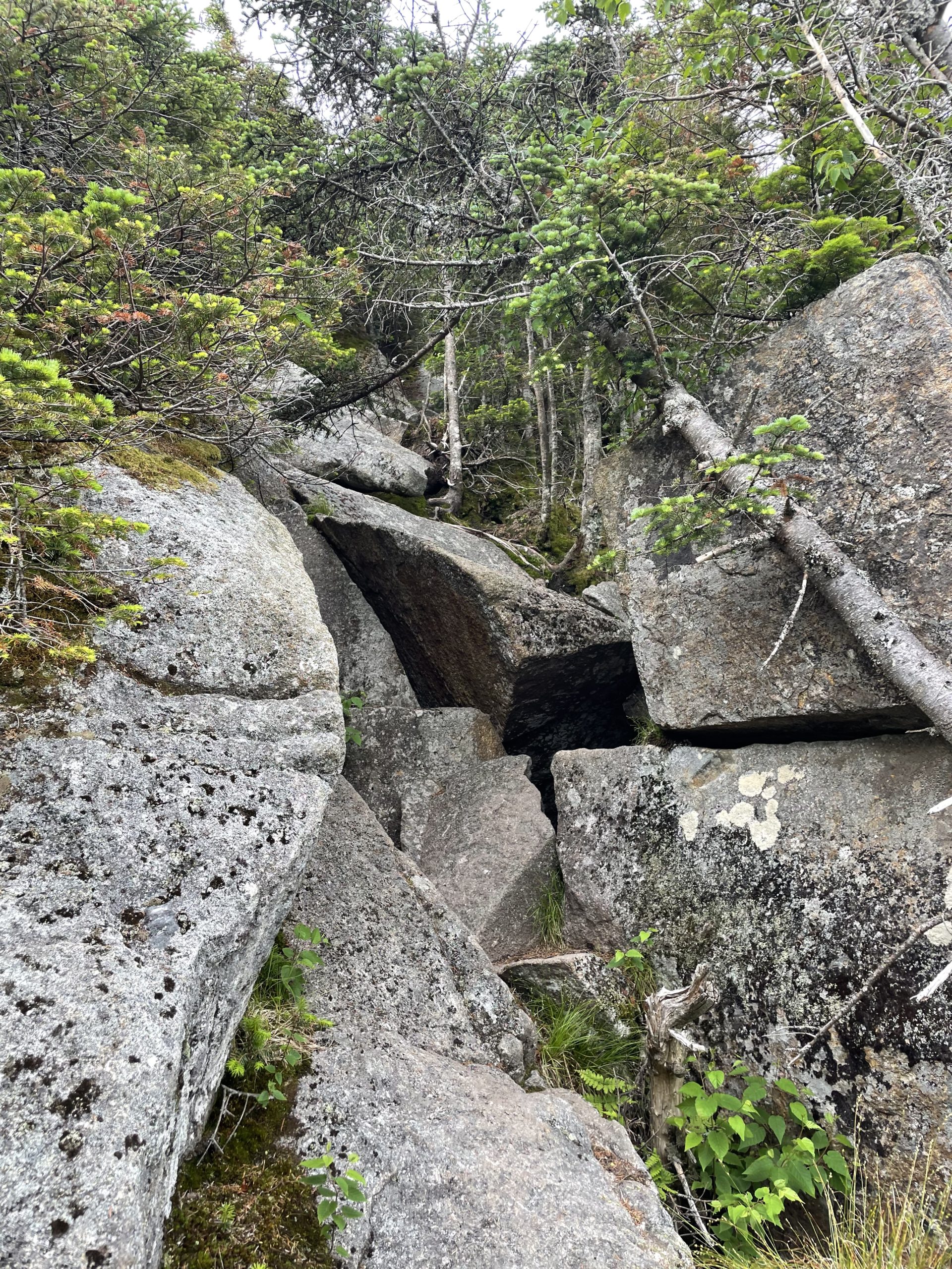
On Kinsman Ridge, I also learned that elevation profiles can’t tell you much about how hard the trail will be. The ‘flat’ spots between peaks were some of the toughest, a scramble through boulders and bogs that I took at a snail’s pace. In one place, the gap between two granite blocks was filled with a treacherous-looking puddle of muck. I cautiously dipped my pole in to gauge the depth, and it sank about two feet deep.
A few minutes later, I ran into my first southbound thru-hikers! They were picking their way through the rocks with surprising ease. I was delighted to have finally met some ‘sobos,’ and asked them excitedly what Maine was like. They shrugged and just said, “Pretty much like this.”
The trail up Kinsman ridge.
I only went thirteen miles that day, but it felt like twenty. I stopped at the Kinsman Pond shelter, where an AMC caretaker issued me a thru-hiker pass and showed me to a tent platform. For the next few days I’d be in their territory, paying five dollars a night to stake my tent awkwardly on boards among the crowds. It may be Forest Service land, but the AMC runs the Whites.
2. Franconia Ridge
Thursday started out with a steep descent, from Kinsman Pond just below the summit down to the lower and gentler shores of Lonesome Lake. Here I found the first of the AMC huts, their network of off-grid guesthouses scattered among the peaks. Reservations are pricey and hard to come by, but just stopping in for a snack feels luxurious. The huts are staffed by ‘croos’ of enthusiastic young people, who are all amazingly friendly, fun to talk to, and hopelessly overworked.
Lonesome Lake Hut had a pleasantly relaxed atmosphere that day. When I came in, I found a croo member sitting in a hammock, reading a book called Bogs of the Northeast. I told him about the bog full of pitcher plants I’d seen on the other side of the ridge, and helped myself to a coffee and a muffin. Then I went on my way down Franconia Notch.

Pitcher plant flowers taking over at Harrington ‘Pond’.
It’s fitting that the passes through the Whites are called ‘notches’ instead of ‘gaps.’ They look like they’ve been chiseled into the rock, as I’m sure they were by glaciers long ago. At Franconia Notch I crossed the last interstate along the trail, I-93 winding north towards Sherbrooke, Quebec. I stopped for lunch by the banks of the Pemigewasset before starting off on the big climb up the ridge.
Franconia Ridge is a stunningly beautiful place. The entire ridgetop stands above the trees, with clear views of every peak for many miles. It’s one of only three ranges in New England with peaks above 5000 feet, the other two being the Presidentials and Katahdin. This rugged, scenic climb up Mt Lafayette is one of the best hikes there is.

The view from Mt Lincoln north to Mt Lafayette. The smaller peak in the middle is Mt Garfield, and you can see the Presidentials peeking through to the right.
As I made my way through this alpine wonderland, I saw an older guy walking the other way with an AT tag on his pack. I asked him if he was a sobo thru-hiker and he said no, he was just doing a section. Why, then, did he have a tag on his pack? He said he’d just wanted to have one and asked for it. Because, you see, this guy was on the Appalachian Trail Stewardship Council. Which, he explained, meant he was one of the fourteen people who basically ran the ATC. I was too tired to make a coherent reply to that, so I just said, ‘Wow.’
My destination for the night was the Garfield Ridge campsite, about 3 miles from the top of Mt Lafayette. I figured it would be a nice downhill along the ridge to get there, until I looked northeast from the peak and saw Mt Garfield. It was lower than the surrounding mountains, but shot up like a tower from the valley floor, and a got a bad feeling that my day wasn’t over yet.

Did I mention there were ravens at the top?
Sure enough, Mt Garfield was a bear. The way down from Lafayette felt almost vertical, as did the climb back up on the other side. I found myself crafting quips about the mountain to pass the time (“Mt Garfield, like the assassination of its namesake, is brutal and pointless”). There were lots of weekend hikers headed that way there as well, and they seemed even less happy about it than I did. I heard about a ten-year-old girl and her dad out there who were still struggling up the hill as it got dark. When I finally got to camp in the fading light, I quickly made myself dinner and went to bed.
3. The way to Crawford Notch
Friday started with another grueling climb down Mt. Garfield. I was so relieved when I got to the bottom that I almost didn’t mind the rocks for the next few miles. When I stopped in the Galehead Hut for coffee, the croo offered me a surprise challenge. Could I eat a giant pancake twice the size of a dinner plate in one sitting? I took one look at the thing and thought, sure, that doesn’t look so bad! Never say no to a free pancake. So I sat myself down and ate it.

The oversized pancake.
After completing the ‘giant cruller challenge,’ I sped up the slope to South Twin with renewed energy. There, as elsewhere above treeline, I stopped to marvel at the delicate alpine flowers and dwarf trees that spread across the stony ground like turf. There’s the ‘pincushion plant,’ diapensia; a spidery white flower called Greenland stitchwort; willows with cottony tufts barely six inches high; and a kind of birch with leaves the size of your fingernail. I could have spent hours up there just exploring these miniature gardens above the clouds.

Greenland stitchwort (Minuartia groenlandica).
The rest of the day was an easy downhill walk. The path wound down the ridge to Zeacliff, a sheer drop giving way to a vast expanse of forest, cliffs, and peaks. Below lay Zealand Notch, an ice-carved gash through the high country. I walked down into it along a roaring brook, diving into the falls at the bottom to cool off. A few more miles and I’d be at my camp for the night, a spring-fed lake in the bogs called Ethan Pond.

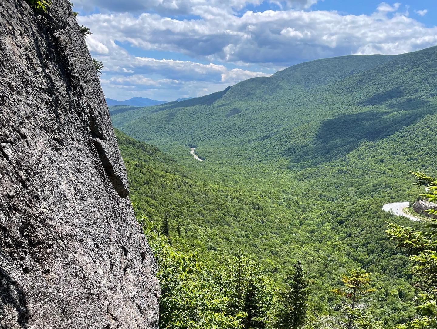
The view from Zeacliff.
Saturday was a short day, and a rainy one. I spent most of it at the Highland Center in Crawford Notch, an enormous, luxurious lodge run by the AMC. It was teeming with tourists and vacationers who were gearing up at LL Bean rental kiosks, bubbling with excitement at the adventure of being in the mountains. Luckily for us thru-hikers, they also had a cafeteria, and we’d arrived in time for breakfast. I chatted with a fellow northbounder, a retired lawyer from Florida, over coffee and eggs, and waited out the bad weather until my bus came around noon (they have buses to the trailheads too!).
That afternoon I climbed up Webster Cliffs, another steep ascent with stunning views. At the end I reached Naumann Tentsite and the enormous Mizpah Spring Hut, my starting point for the Presidential traverse the next day.
4. Presidential Peaks
Before I go on, it’s worth stopping to think for a moment about the Presidential Range. How and why did these mountains get their names?
It turns out it started in 1784, when some New Hampshire notables went on an expedition to the Whites. In a fit of patriotic fervor not uncommon among Anglo-Americans in those days, one of them called the highest peak ‘Mount Washington.’ Before that it may have been called Sugarloaf by the settlers, and the Indigenous name Agiocochook was used by Thoreau and others into the 1800s. But the spur-of-the-moment patriotic designation stuck, adopted as an official name by the U.S. government.
After that, I guess it was a free-for-all. Every soaring peak had to be named for a famous politician of the USA. So the triumverate of founding presidents claimed the highest peaks, surrounded by lesser luminaries such as Benjamin Franklin, Daniel Webster, and Henry Clay. Even latter-day saints like Dwight Eisenhower and (for some reason) Franklin Pierce have their place. Meanwhile, the mountains just sit there, being high.
So, I suppose, it was in keeping with the spirit of the enterprise that I summited Agiocochook on the Fourth of July weekend.
The way up the highest peak in the Northeast was steep and strewn with rocks, but gentle compared to the paths I’d walked for the past few days. As the wind picked up, the temperature dropped, and the land fell away below me, I felt a real sense of accomplishment and wonder at being on top of the world. Until I saw the crowds.

The line to take a picture at the summit.
Of course I knew you could drive up Mt Washington. I’d done it before, long ago. And I knew you could take the cog railway up — I’d done that too. But the effect of a few thousand people doing both at once was to give the summit a sort of Disneyland feel. The contrast with the rugged, wild mountainside beyond couldn’t have been starker. I think I now understand why hikers started mooning the cog — out of sheer frustration.
I hung around the top a bit, trying to imagine what it would be like without the food court and the line to take summit pics. I didn’t bother getting one myself, just snuck up behind the big cairn to say I’d made it to the top. I even went inside and got a snack. Then I quietly apologized to the mountain that we’d turned it into a theme park, and moved on.
The rest of the traverse was wild and beautiful. You start down the slope in a felsenmeer, or sea of boulders. Then the trail levels off, and you wind along the ridge, skirting huge stacks of stones that mark the peaks, the clouds almost close enough to touch and the valleys far off below. Sometimes a mat of black spruce covers the ground, sometimes a field of sedge and wildflowers. Sometimes you have to hoist yourself up through a crag, squeezing between rocks that dwarf you with their bulk.

The trail’s that way.
When I reached the base of Mount Adams, I decided to climb it, even though it was a steep climb off-trail. I left my pack at the bottom and clambered to the top over piles of rock that clattered under my feet. I crested the summit and sat in a sheltered spot, looking at the wild vastness of the Great Gulf. For the first time that day, I felt solitude, and the stony weight of the mountains all around me. I sat there very still for a few minutes before heading back down.

The view from Madison Springs.
There was another hut at the base of Mt Madison, and then I made the final climb of the day. It was also the hardest, and was followed by an endless descent that undulated down towards treeline. Slowly, the patches of fir crept closer and closed in around me, and still the trail plunged down along boulders and ledges. After an eternity, I heard rushing water ahead, and found myself deep in the Great Gulf along a cascade. I walked down the path to a wilderness campsite and stopped, sunburnt and exhausted, for the night.
5. Wildcat Ridge
Monday started as another restful day. I got up late and walked five gentle miles down to Pinkham Notch, where the AMC visitor center was waiting with food and running water. Sunday’s crowds had vanished, and I just relaxed in the cafeteria, as the hiker-friendly kitchen staff offered me leftover food. Then I left and walked on towards the last range of the Whites, which also has a reputation as the hardest.
About halfway up Wildcat Ridge.
At the time, though, I was just thinking of putting in more miles for the day. So when the trail started climbing up a crevice in a cliff, I didn’t notice too much. Then it kept going, climbing almost vertically for long sections, until it levelled out and a random ski lift appeared in a clearing. I was near the southern summit of the ridge, which is known (for some reason) as ‘Wildcat D’. By that point I was noticing how slow the going was, and realized I wouldn’t be making it as far as I had thought. The next few miles of ridge reminded me of Kinsman, continual ups and downs that were more like bouldering than hiking. Eventually, I reached the official peak at 4422 feet.
And then, as evening began to set in, I clambered down another thousand-foot series of ledges to the last hut of the Whites, Carter Notch. The guests were eating dinner inside, so I just hung outside for a minute talking to the work-for-stay southbounder, filled up my water at the faucet, and left. He’d said the next few miles were more like a trail.

Looking southeast at sunset from Mt Hight.
And he was right! The ascent up to Carter Dome was rocky, but much easier than what had come before. I got one last 360 view of the Whites from Mt Hight that night, watching the sun set over Mt Adams. The next day I traversed the rest of the Carter-Moriah range, and after a long, slow, rocky day emerged onto a gentle forest path along the Rattle River. The last three miles flew by, and before I knew it I was at the road in valley. Out of the Whites.
I’m taking a good long rest at the hostel here in Gorham. One hundred miles is a long way to go on a trail that’s more of a climb than a walk. From what the southbounders tell me, Maine is more of the same, and I’m not planning any big miles for the rest of the trail. My job now is to enjoy the northern woods, and maybe if I’m lucky I’ll see a moose. I’ve walked 1900 miles towards Maine, and I’ve almost arrived.

This website contains affiliate links, which means The Trek may receive a percentage of any product or service you purchase using the links in the articles or advertisements. The buyer pays the same price as they would otherwise, and your purchase helps to support The Trek's ongoing goal to serve you quality backpacking advice and information. Thanks for your support!
To learn more, please visit the About This Site page.

Comments 6
I am enjoying reading your posts. Keep it up, almost there now. Mahoosuc notch is super fun and the farm sucks, but its just one more mile. The pond at the tip is great for a swim and then onwards to Old Speck!
Have fun out there, really starting to warm up now!
Greg
Mount Pierce, upon the shoulder of which is the campsite where I am the AMC caretaker, was named for Franklin Pierce, the only president born in the State of New Hampshire. It received this designation in 1913 and was previously named Mount Clinton for a governor of New York. Thus there is still a Mount Clinton trail leading to the summit. Happy hiking!
Thank you so much for writing about your hike through the Whites and the photos you included. Years ago while hiking the 48 4000 footers of New Hampshire, I experienced much of what you wrote about…it was a nice trip down memory lane for me and an enjoyable way to spend some of my afternoon. Good luck with the remainder of your hike and I do hope you will write some more about your adventure. Enjoy your hike, stay safe and continue to be appreciative of nature.
Red Squirrel, this is one of the best posts about the White I’ve read on the Trek! I remembered my own AT hike through the Whites as well as other peak-bagging hikes.
And yeah there are lots of hikers out there…there are also many folks working hard to keep the area in pristine shape. Maybe you will join them when you move to Portland? Assuming you mean the Maine city…
“.com”
Scrolling through the trek and recognized your trail name! We met briefly on my second day on the LT – taking a break just past rt. 9. Great post! And congrats on being so close 🙂
I live in Berlin N.H. I just came across this post. I love how you are so descriptive in your writing. I am disabled and to follow and watch all you hikers is like a dream I’m living through all of you. Your an inspiration to me . Thank you so much for sharing your journey.