 ">
">
AZT Passage 37: Starting out at Grand Canyon’s South Rim

An open space near the southern end of this passage. Though forested throughout, the trees in section 37 have more gaps between them than average, allowing a broader view of the landscape.
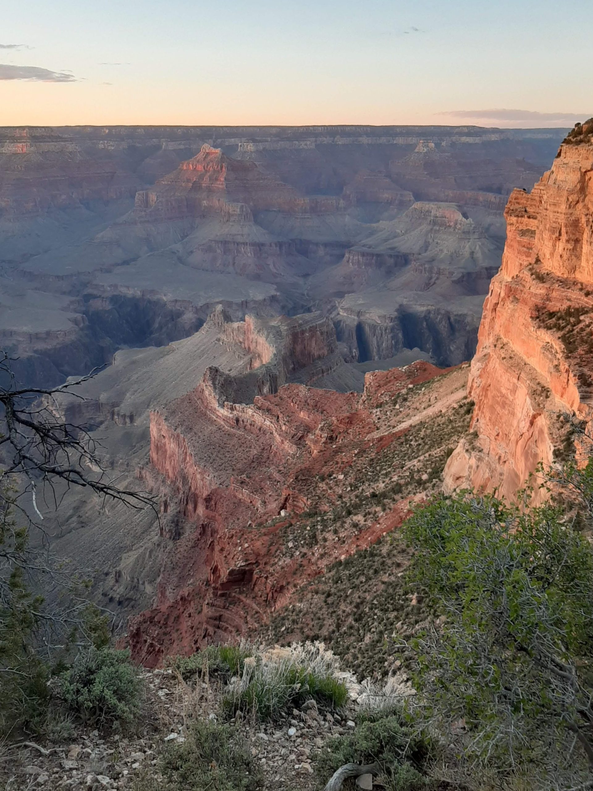
Though it’s listed as the South Rim section of the trail, this passage mostly takes you through Kaibab National Forest and the back ways of Grand Canyon National Park, only occasionally hinting at the chasm to come. There’s plenty to enjoy about the trip, however– as well as a number of options for detours. And when you’ve reached the northern end you’ll be left looking down over the rim of the Grand Canyon.
Basic Info
- Length: 22.5 miles, one way
- Expected Completion Time: One day (if thru-hiking at a pace of 20-30 miles/day) 4-5 days (if day-hiking 4-6 miles/day)
- Location: South Kaibab Trailhead in GCNP to Tusayan Ranger District (roughly 15 miles east of GCNP visitor’s center on E Hwy 64 and 2 miles south from there). Maps are available on the Arizona Trail Association website.
- Trail Type: Out and Back, though it does partially follow a few looped trails in the Tusayan Bike System
- Scenery: Pinon and ponderosa pine forests with the occasional stone ledge, views of the Grand Canyon toward the end
- Terrain: Easy. The hills are for the most part gentle and the trail is clear.
- Navigation: For most of this section, the AZT is a well-marked dirt path, with both markers from the ATA and Kaibab National Forest. The trail occcasionally follows forest roads and later sections (namely the Tusayan Greenway) are paved. Toward Tusayan, trail markers will show numbers corresponding to the different loops of the bike trail. The signs you want to follow will also have the AZT logo on them and crossroads are generally well-marked.

Alongside the trees in this passage, there are also a variety of low rock ledges. I don’t actually know what they’re called, or the type of rock (if you do, please let me know!), but I think they’re lovely.
Getting There
The northern trailhead is the South Kaibab in Grand Canyon National Park. To do this section southbound, you will be headed away from the canyon. You’re not allowed to park at the trailhead, so you can either leave your car in the small lot across from the turnoff (this is nearly always full April-October) and walk, or take the shuttle from the Visitor’s Center (orange route). Shuttles usually run year-round, but did close from March to August this year due to Covid precautions. The current status and schedules for park shuttles are found on the NPS website.
To reach the southern trailhead at Grandview Tower, head east on Highway 64 in the park. You’ll see a turnoff for a dirt road on your right (it’s the one after the Grandview Overlook if you’re coming from the South Rim). Turn here, and after about 2 miles, you’ll see an old fire lookout tower with restrooms and an informational sign. This is the trailhead parking lot.
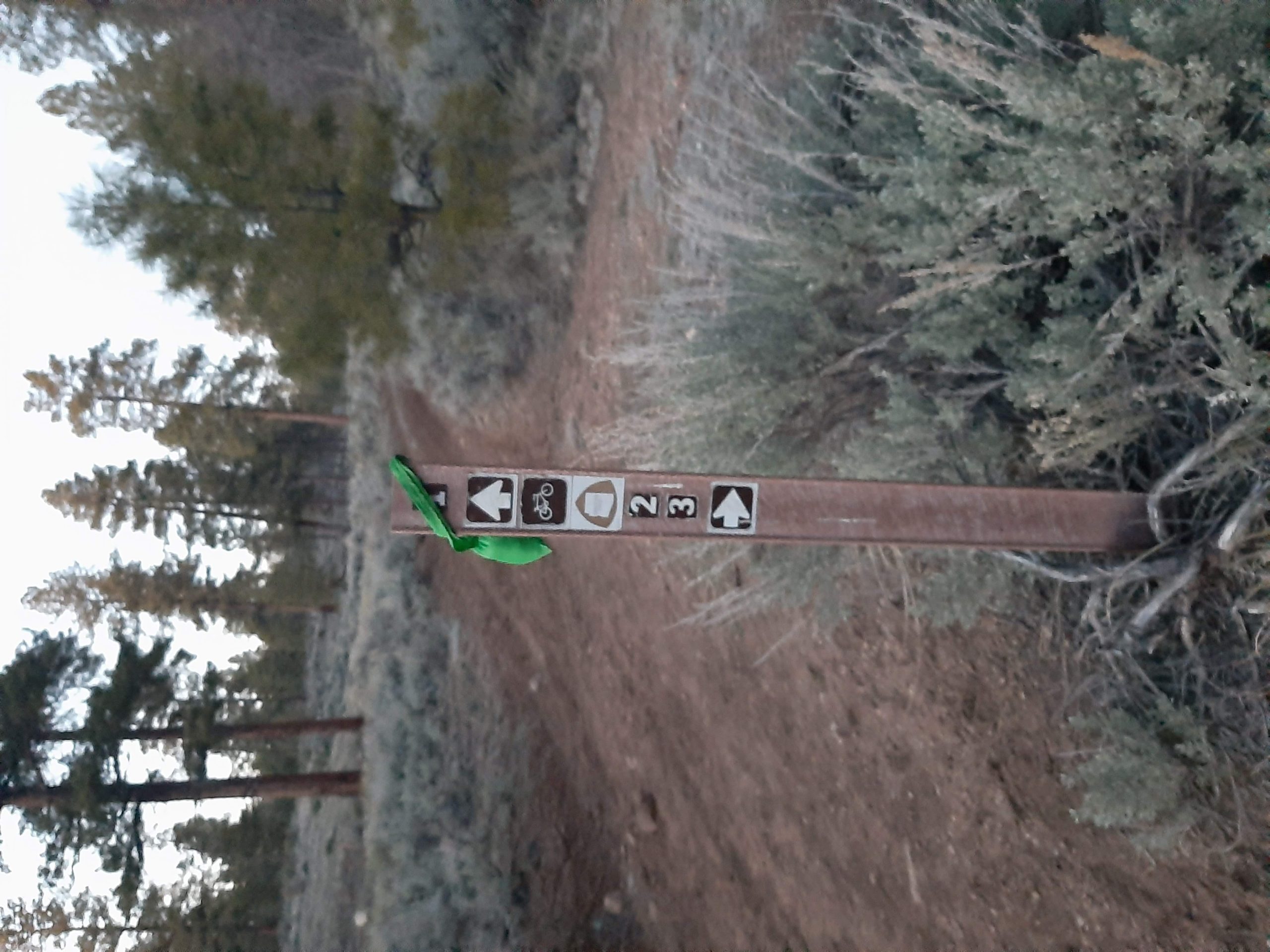
AZT markers near Tusayan will also give directions to the various paths in the town’s Bike Loop. Loop 1 is 3 miles long, 2 is 8 and Loop 3 covers a total of 9 miles. Each makes for an excellent day trip.
Direction
You can hike this trail either N-S or S-N. The directions aren’t that different if you’re not planning a thru-hike, but the northern trailhead is a bit more centrally located (and accessed by paved roads, if that’s a concern).
Why Hike This Passage?
I think it’s a great way to familiarize yourself with the area around Grand Canyon. While the majority of the trail runs through the national forest rather than the park, it offers a closer view of the forest that most only drive through. Unlike other sections of the trail in this area, you won’t have to go too far out of your way to access this.
There are plenty of detours and options to take shorter loops through terrain that feels more remote than it probably is. And if you’re thru-hiking, this section will likely be a welcome rest, whether you’re taking it on before or directly after the inner gorge.

Climate and Weather
Northern Arizona does have four seasons. Before you go, be sure to check general weather conditions. Wear spikes if it’s icy, layers if you’re planning to be out early or late (very low humidity so the temp changes dramatically) and always be sure to carry extra water.
Gear Suggestions
This section doesn’t call for a lot of specialized clothing. Dress for the weather, in sturdy clothing. If you’re planning on camping, remember that there’s not a lot of humidity, so the temperature will fall sharply at night. Make sure to bring plenty of water, especially if you’re headed south.
Camping
Camping is allowed in Kaibab National Forest, for a maximum of 14 days at a time. Just find a turnoff and set up your tent. You might need to venture to FRs 302 or 303, a little ways distant from the trail, where the sites are more clearly marked. Before you go, be sure to check Kaibab National Forest’s website for fire restrictions or other advisories.
You can also camp at Mather Campground in the park (with full facilities), which the trail passes very closely. You’ll need a permit to camp there ($6 for a hiker/biker site, more if arriving by car), and this being GCNP, you’ll want to make reservations in advance.


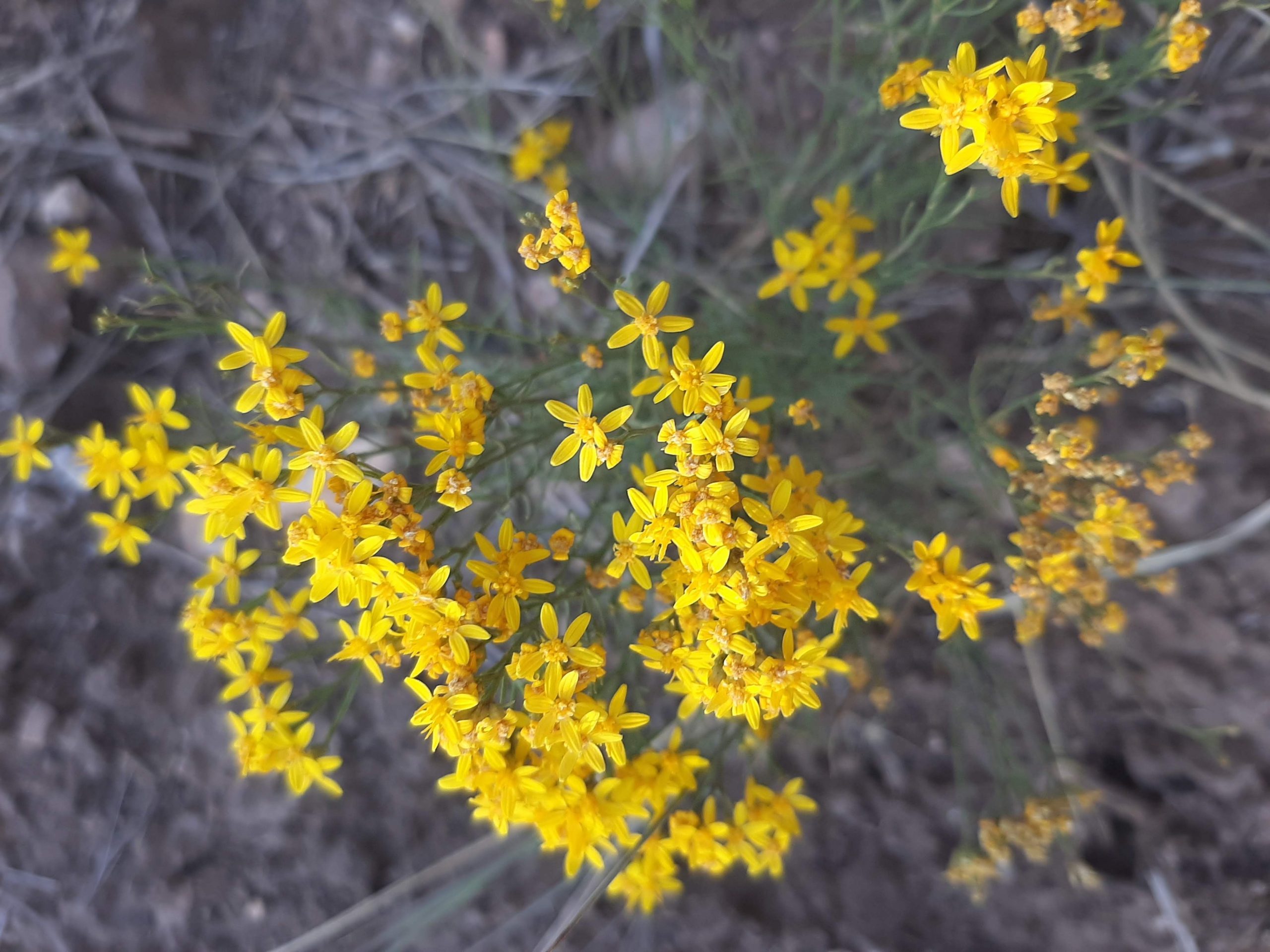
Both rabbitbrush (left) and sagebrush produce yellow flowers in early fall. Open areas full of these shrubs are a common sight along this section of the AZT.
Highlights
You’ll be moving parallel to the south rim of the Grand Canyon for much of this hike, though a few miles to its south, so you won’t be able to see it most of the time. What you will be able to see is the Tusayan Ranger District of the Kaibab National Forest. So ponderosa and pinyon pines, sage- and golden rabbit- brush, and a variety of sparkling and colored stone. Personally, I’m a big fan. But tastes will vary for sure.
Some things to look forward to on your trip (list order is based on distance from southern trailhead):
- Watson Tank—typical of my experience with tanks in Arizona, you’ll be looking at a blue splotch on your map with anticipation, only to realize what it is is a sign in front of an indent in the ground. There’s a nice little rise above it, though, and a clear view of the sky, making it a lovely place to rest. Or to visit on a day trip (it’s about 4 miles from the southern trailhead).
- ??—If it has a name, I don’t know it, but there’s a bit about 3 miles south of Tusayan where trees and stone give way to a small plain of sage and rabbitbrush (on me, it comes to mid-calf). It’s still ringed by trees and in a small depression, but for whatever reason I find the wind blowing through the brush otherworldly and beautiful. This is best in early fall, when the sunlight provides welcome warmth, and the brush is topped with golden flowers.
- Tusayan Bike Trails—If you’ve only got a few hours, this is an excellent way to tour the forest. Park either on N Long Jim Loop Road (not the paved end) or at the greenway parking lot in Tusayan just north of the Imax. Follow the greenway to the underpass tunnel and from there the signs will have numbers as well as the AZT logo. All three are loops ( Route 1 is 3 miles, Route 2 is 8 miles and Route 3 is 9 miles) and well marked, except I can never find the turnoff where 2 and 3 separate. You’ll get to see a little bit of the forest, including the plain described above (Routes 2 and 3) without having to decide when to turn around. You usually also see a few elk or mule deer here, especially along Route 1. (Also–this is called a bike loop, but other forms of transport, including hiking, are welcome.)
- Tusayan Greenway—after a long hike, sometimes a paved path with company is a welcome change. You go through a graffitied tunnel underneath the main road into the park and emerge in civilization. (1 mile south of SK to the town of Tusayan about 6 miles down)
- Glimpses of Grand Canyon— if you’ve been heading north on the AZT, you’ve probably started to feel a lot of anticipation. This is paid off toward the end of this passage, when you emerge from the forest near the South Kaibab trailhead and get a close view of the Grand Canyon. If thru-hiking, you’ll have your work cut out for you but right now, you get to enjoy the view.

Watson Tank, despite what the map shows, usually contains very little water.
Water Sources
There aren’t very many, as Watson Tank is what I think of as an Arizona classic. Supposedly it sometimes fills, but I have yet to see it. (Obviously, if there is water, it’ll need to be filtered).
Water is also available at the South Kaibab Trailhead.
This section does run fairly close to both the visitor’s center plaza in Grand Canyon National Park and the town of Tusayan, however, so filling up there shouldn’t be a problem. (For planning purposes, both are closer to the northern end of the passage).
Resupply Options
You can detour to get supplies from either GCNP or Tusayan, near the northern end of this trail. You can get to Tusayan by taking a left turn after exiting the connecting tunnel and following the greenway about a mile to its end (if heading south, you’ll instead go straight rather than turning at the tunnel). At the other end of the greenway are signs directing you to locations within the park. You’ll need to pass the AZT turnoff to reach them.
Primitive restrooms and trash cans are located at both the Grandview Tower and South Kaibab Trailheads.
This passage ends at the South Kaibab Trailhead. Before continuing, take time to wander around and enjoy the views of the Grand Canyon.
Closing Thoughts
This passage probably isn’t what you’d expect from its title, but I still feel it’s worth seeing. It takes you through the back of the area that many won’t see. And as a start to this hike, I was grateful for the easy terrain and numerous access points. Things have been busy lately, and it was lovely to take a few moments to slip into the woods. Hopefully I can keep up that enthusiasm.
Thanks for reading! I’ll be back in January with Passage 36: Coconino Rim. Until then, have a great hike.

This website contains affiliate links, which means The Trek may receive a percentage of any product or service you purchase using the links in the articles or advertisements. The buyer pays the same price as they would otherwise, and your purchase helps to support The Trek's ongoing goal to serve you quality backpacking advice and information. Thanks for your support!
To learn more, please visit the About This Site page.

Comments 3
Great coverage on section-hiking the AZT! Thanks so much for dedicating time to this. I will help promote your articles through the Arizona Trail Association. The stone cliffs you saw on passage 37 are Kaibab Limestone — @ 290 million years old. You can sometimes find alcoves within these rock features that were used as shelters by Indigenous people. The Arizona Trail Association is currently working on a reroute of this passage that would eliminate the dirt roads and paved Tusayan Greenway Trail portion; instead, singletrack will head generally north from near Watson Tank to the South Kaibab Trailhead. Stay tuned for more details on that…
Glad you liked it! And thanks for all the info–I’m always happy to learn more about the trail. Can’t wait to see what that’ll look like.
–A