 ">
">
The Best Blue Blazes on the Appalachian Trail – Part 3
Everybody whip out your favorite guide book because it’s time to talk about more of those spectacular blue blazes scattered around the Appalachian Trail. In our last installment we talked about quite a few trails you won’t want to miss on your AT excursion, but there are plenty more where those came from. So here are a few more of the best blue blazes on the Appalachian Trail!
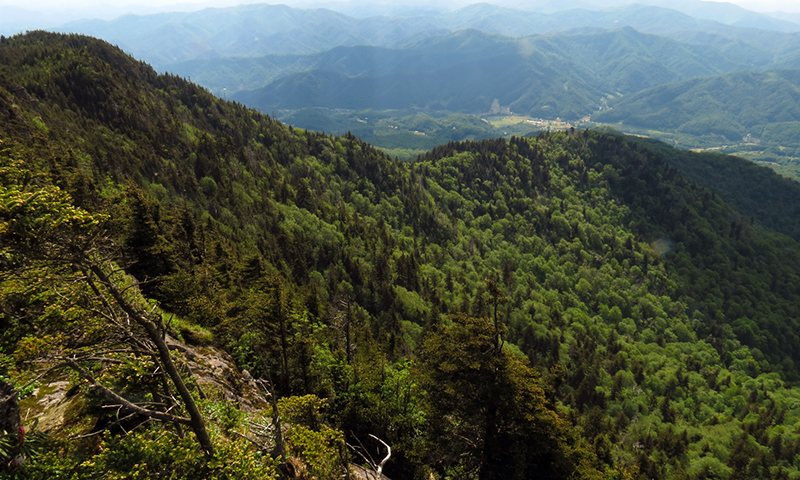
1. The Complete Roan Highlands Experience

View of Grassy Ridge Bald from Round Bald in the Roan Highlands. Photo courtesy of Alan Cressler.
The Roan Highlands is one of the most beautiful sections of the Appalachian Trail. Sadly, just following the white blazes grants only partial access to all the highlands have to offer. There are eight major peaks that make up much of what we consider the Roan Highlands. Of these eight peaks only seven are open to the public. Of these seven the AT only takes hikers over five (Roan High Knob, Round Bald, Jane Bald, Little Hump Mountain, and Hump Mountain). Thankfully the remaining two peaks, Roan High Bluff and Grassy Ridge Bald, are within reach of AT hikers. This just means that if you want the complete Roan Highlands experience you’re gonna have to do a little blue blazin’.
Views from the platform at Roan High Bluff. Photo credit BlueRidgeKitties. CC BY-NC-SA 2.0. CLICK TO ZOOM!!!
Roan High Bluff sits with Roan High Knob in the southern section of the highlands on the AT. The path to Roan High Bluff is not explicitly marked in AWOL’s 2015 AT Guide Book. So be sure to write this one down. At mile marker 376.8 hikers will reach a clearing at Toll House Gap: the saddle sitting between Roan High Knob and Roan High Bluff. This is also the former location of the Cloudland Hotel. From here hikers must venture about 0.1 miles down to the saddle’s parking area visible from the clearing. Here hikers can find signs for the Cloudland Trail leading 1.2 miles to the 6,267′ Roan High Bluff. It’s worth noting that the peak’s actual summit is off limits to the public. The National Forest Service (NFS) found cliffs around the peak were home to threatened species. As a result they placed fenced boundaries accordingly, within which sits the peaks’s official summit. Thus, a nearby viewing platform serves as the accessible “summit” for the peak. So please respect the established boundaries during your visit. You may not be able to officially bag this peak, but the views from the platform are still worth your while.

The best time of year to find yourself in the Roan Highlands is actually in late June, a time Nobos & Sobos usually miss. Late June is peak blooming season for the rhododendrons turning the grassy balds into luscious pink beauties. Photo credit Brenda Wiley. CC BY-NC-ND 2.0. CLICK TO ZOOM!
Further north up the trail hikers will find Grassy Ridge Bald. The peak sits with Round Bald and Jane Bald in the central section of the Roan Highlands. Due to its series of open balds this part of the highlands also known as “The Grassy Ridge”. Grassy Ridge Bald is located just north of Round and Jane Balds and south of Yellow Mountain Gap. A trail leading to the balds’s summit connects with the AT at mile marker 381.0. The spur trail leads hikers 0.5 miles to the bald’s summit where they can take in 360 degree views of the surrounding landscape. The summit also offers prime camping spots for those looking to spend the night. Those that do are often rewarded with both a magnificent highland’s sunset and sunrise. Unlike it’s sister balds, with an elevation of 6,189′ Grassy Ridge Bald is the only bald Southern Sixer in the highlands. For northbounders this means this bald is their last chance to soak up the joys of 6,000′ elevations until New Hampshire. Speaking from experience that’s a hell of long wait. So don’t let this opportunity pass you by.
Last but not least, be sure to take the 0.3 mile detour to Overmountain Shelter. Even if you don’t plan on spending the night there it’s worth the side trip. It’s easily one of the most unique shelters on the AT coupled with one of the better views you’ll find at any shelter site. You can hardly say you’ve had the “Complete Roan Highlands Experience” without it!
2. Apple Orchard Falls

Photo courtesy of Margie Hunter
Virginia is a state ripe with waterfalls. Thankfully, the AT is nice enough to give hikers an opportunity to go and see quite a few of them. One of the more spectacular Virginia waterfalls hikers can blue blaze to is Apple Orchard Falls. Just south of the climb up/down Apple Orchard Mountain hikers can find a blue blaze leading to the falls at mile marker 767.3. After an easy 1.1 mile hike down this trail hikers will emerge at the 200 foot Apple Orchard Falls. The falls provide an impressive multi-tiered cascade crashing on the rocky ledges below. The NFS constructed a boardwalk and viewing platform below the falls for optimal viewing. For those not out on a thru-hike the falls are also accessible from the Blue Ridge Parkway (BRP 78.4). They can be enjoyed as part of a short out and back venture or turned into a longer loop excursion by combining it with a few other trails. This blue blaze may make for a longer detour than many thru-hikers are willing to endure, but for any waterfall enthusiast it’s certainly worth the walk.
3. Hawksbill Mountain

View of Hawksbill Mountain from Crescent Rock Overlook (Mile Marker 929.4). Photo courtesy of Alan Cressler.
Shenandoah National Park is a highly anticipated part of the AT for a good reason: it’s stunningly beautiful. During their 100 mile jaunt through the park thru-hikers will pass by Stony Man summit. At 4011′ some consider it the highest point in the park on the AT (even though it’s 0.2 miles off trail). Yet, Stony Man is not the tallest mountain in Shenandoah. That honor belongs to Hawksbill Mountain. Sitting just 4.7 miles south of Stony Man on the AT Hawksbill squeaks by its closest competition by a mere 40 feet. Also like Stony Man Hawksbill is easily accesible from the AT! Hikers can find their way to Hawksbill’s summit by way of the Salamander Trail at mile marker 927.9. Taking the trail leads hikers about 0.7 miles and through 500 vertical feet of swtichbacks up to the summit.
Hawksbill’s summit has been fairly well establish by the park service. They constructed a stone viewing platform which provides excellent views of the park. This includes views to one of the park’s rockiest summits upon Old Rag. The summit may also earn hikers a glimpse of a Peregrine Falcon or two. Since 2008 Hawksbill’s hosted efforts to help re-introduce the falcon’s population in the park. Near the summit hikers will also pass by the three-sided shelter known as Byrd’s Nest #2. It’s worth noting that this shelter is for day use only. In fact, much of the area around the mountain’s summit has been closed to backcountry camping. This is an effort by the park to help with plant preservation in the area. So come nightfall you don’t have to go home, but you can’t stay here.

4. Annapolis Rocks

Photo courtesy of Joe Newman. CC BY-NC-SA 2.0.
AT thru-hikers only spend 40 miles total in Maryland. Yet, in that short distance there are still some worthwhile sights to behold. For example, take the ever popular Annapolis Rock. A short 0.2 mile spur trail connects with the AT at mile marker 1147.9 leading hikers down to the rocks which provide fantastic views of the surrounding area including the nearby Greenbriar Lake. The rocks themselves offer a wide variety of opportunities. There are great spots to relax as well as places to climb, scramble, or dangle to your heart’s content.
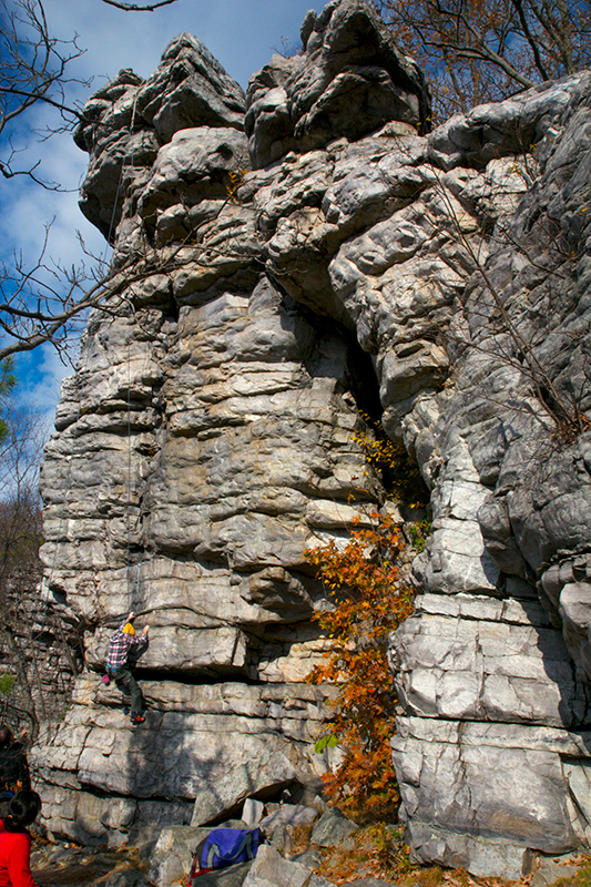
Climbers ascending Annapolis Rock. Photo courtesy of roman.petruniak.. CC BY 2.0.
Though, Annapolis Rocks is more than just a pretty view. It’s also a popular campsite with it’s own on-site caretaker. There are 16 campsites on location including at least two group sites. There is no fee to camp here but the camp sites are first-come, first-serve. However, Annapolis Rocks is a highly overused area. Barriers have been set in place to help restore vegetation in the area suffering from the site’s high traffic. As a result you are only allowed to camp in one of the designated sites and no where else. That means if they’re all full up you’ll have to find a new place to camp down the AT. Annapolis Rocks also serves as popular rock climbing destination for locals. So don’t be surprised to find a few folks scrambling up from the bottom of the cliffs during your visit.
5. The General

A derelict piece of coal-mining equipment dubbed “The General”. Photo courtesy of Joe Coyle. CC BY-NC 2.0.
Throughout its length the AT passes by many monuments to history. Some of these are literal monuments while others are just abandoned relics. This next blue blaze falls into the latter category. At mile marker 1173.4 the AT intersects with the blue blazed Sand Spring Trail. After about 0.3 miles Sand Spring connects with another spur trail leading hikers another 0.2 miles. These two trails lead hikers to “The General”: a rusted out, gas-powered excavator from another time. Its distinguished namesake comes from a plate on its rear perhaps denoting it’s model or manufacturer. So what is a monster like this is doing out in the middle of the woods in the first place?
This area commonly referred to as Pennsylvania’s State Game Lands #211 is also known as Stony Valley. It so happens that Stony Valley was ripe with industry back in the day. The area was home to numerous industrial operations including coal mines, quarries, lumbering, and more. As time went on and the area’s resources started to dry up then so did the industry. As a result several historical nuggets, like the General, can be found near the AT as it travels through the area.
This entire side trip to the General will take hikers about 0.5 miles one way. This usually falls within most thru-hikers minimum acceptable threshold for blue blazes. Of course, if you have more of an appetite for the lands that time forgot the eight mile Stone Tower Loop is always an option. Also making for a good day hike, the loop not only takes you past the General but also other remnants of the areas industrial days. This includes the Stone Tower and the abandoned 1850’s town of Yellow Springs.
6. Pinwheel’s Vista

West-to-northwest view from Pinwheel Vista. If you look closely High Point Monument is visible in the far left side of the picture. Photo courtesy of Nicholas A. Tonelli. CC BY 2.0.
Before northbound hikers can finally bid farewell to New Jersey they must first conquer the state’s final ascent: Wawayanda Mountain. After tackling the 1.4 mile climb up the mountain hikers are rewarded with Pinwheel’s Vista. At mile marker 1358.1 a 0.1 mile blue blaze will lead hikers to this popular New Jersey vista. Named after trail maintainer Paul DeCoste (a.k.a. Pinwheel), this spot offers picturesque views of the Vernon Valley. For northbounders this is an exciting opportunity to gaze back over the sections of trail already behind them. For southbounders it’s an chance to preview what New Jersey is going to bring to the table. On a clear enough day hikers are even be able to catch a glimpse of the High Point Monument sitting nearly 21 miles away south down the AT.
Keep a watchful eye as this detour is easy to miss. The blue blazes are at times hard to see. Watch for a large rock cairn at the base of the blue-blazed tree near the trail junction. About another 0.1 miles north up the AT lies another blue blaze marked with a mailbox and sign reading “Old AT Vista 0.8 miles”. If you’ve hit this sign then you’ve gone too far. This second trail is an old route the AT use to follow before it was re-routed in the 1960’s. It will eventually lead to a ridge line providing some additional views off of Wawayanda, but the trail is no longer maintained.

Panorama from the Pinwheels vista. CLICK TO ZOOM!!! Photo courtesy of LA1277. CC BY-ND 2.0.
7. The Lookout

Photo Courtesy of Bill Hevrin. | “The trail rewarded me that day! Thunder and lightening all day long, pushed myself to get there and stretched out all my stuff inside and had it all to myself.” – Bill
The quaint cabin known as “The Lookout” sits alone in the Green Mountains of Vermont. This privately owned cabin is accessible by a 0.1 mile spur trail found at mile marker 1718.2. The owners of the property have graciously permitted AT hikers use of the cabin making it akin to AT shelter, albeit more awesome. While the cabin is unfurnished it offers a fully enclosed space complete with a door and windows. Inside hikers will find a lofted 2nd floor over part of the cabin providing extra space to sprawl out. A brick fireplace is also found inside but the cabin’s owners have requested that no one start any fires on the property. If you’ve seen the burn scars on many of the AT shelters it should be no wonder why. Still, the real draw of the Lookout comes from its signature feature: a viewing perch on the roof accessible by an exterior set of steep stairs… or is it more of a ladder…a stadder? The Lookout’s lookout offers 360 views of the surrounding mountains including Mt. Killington and Pico Mountain south on the AT. Let’s face it. The Lookout is going to be a far cooler place to spend the night then a typical shelter. So why not plan to end your night with a Green Mountain sunset atop the Lookout before retreating inside for a good nights rest?
Taking a break with Flavor Savor atop the Lookout’s perch in 2013. Photo credit Kenny Howell.
8. North Twin
.jpg)
Looking towards North Twin. Galehead Hut in the foreground. Photo courtesy of Kevin Gallager.
As thru-hikers continue their march through the White Mountains they will eventually meet with South Twin Mountain. It should be no surprise to find that a mountain bearing the name “twin” has a sibling resting not far away. The 4,760 foot North Twin Mountain sits not even two miles from it’s bigger southern sister. The AT takes hikers up and over South Twin’s 4902 foot summit but sadly passes North Twin by. But don’t cry for lonely ol’ North Twin. Even without the AT running over its summit it’s actually considered a more popular hike than South Twin. This is mostly because the mountain is accessible via the 4.3 mile North Twin Trail complete with parking on the northern side of the mountain. Even so, North Twin is not out of reach of the AT for any thru-hiker wishing to bag another peak.

View from North Twin looking back at Mount Garfield and Franconia Ridge. Photo courtesy of blackwolf_03278. CLICK TO ZOOM!!!
The 1.2 mile North Twin Spur Trail found can be found atop South Twin’s summit at mile marker 1829.9. This spur trail will lead hikers down through the gap between the sister peaks with plenty of views along the way. Unlike its sibling much of North Twin’s summit is forested in. Thankfully, several ledges surrounding the summit offer excellent views of the surrounding area. While marginally lower than its sister North Twin is still ranked at #12 out of the White Mountains 48 4000 footers. Granted tacking on an extra 2.4 mile round trip onto your White Mountains experience might be a hard sell for some given the similar views achievable from South Twin. Still, any excuse to spend more time in the Whites is a good one. So what do you have to lose?
9. Thoreau Falls

Looking up from the base of Thoreau Falls. Photo courtesy of Jessica “The Hun” Reeder.. CC BY 2.0.
This is another one for those who can’t help chasing waterfalls. Not far north up the AT from North and South Twin in hikers will find Thoreau Falls. A spur trail leading to the falls connects with the AT at mile marker 1838.4 only 5.4 miles south of Crawford Notch. After walking 0.1 miles down the easy spur hikers will emerge upon the large, flat ledges atop the falls. What makes Thoreau Falls particularly beautiful is that it feels as long as it is tall. Looking down from the top it seems akin water slide, though likely guaranteed to be a very uncomfortable ride. Around 80 feet of gradual cascades and slides make up the falls with a few smaller drops here and there.
The flat ledges along its length provide direct and easy access to the falls and are the perfect place for a lunch break. Even more enticing are wading pools usually accessible both near the top and bottom of the falls. During low water levels it’s sometimes safe to scramble down the rocky ledges towards the base of the falls. However, during higher water conditions this isn’t recommended. In addition to the falls excellent views of Mount Bond and Mount Guyot are possible from the accompanying ledges. In summation: an amazing waterfall and great views only 0.1 miles off trail. So there is really no excuse good enough to pass this blue blaze by.

Water cascades farther up the falls. Photo courtesy of Dan Szczesny.
10. Gulf Hagas

Billings Falls in the Gulf Hagas, Maine. Photo courtesy of Fredlyfish4. CC BY-SA 4.0
Maine is often considered the toughest of the 14 states on the AT. However, the hard work is often well rewarded as Maine is also considered one of the most beautiful sections of the entire trail. So it seems fitting that Maine would be the home to a natural feature as epic as the Gulf Hagas. Sometimes referred to as the Grand Canyon of the East, the Gulf Hagas is a nearly four-mile long slate gorge. Carved by the West Branch of the Pleasant River it sports 300 – 400 foot walls in some spots. Also did I mention it’s just brimming with waterfalls?

A view of the rapid wedge in Gulf Hagas. Photo credit Tcpx36. CC BY-SA 3.0. CLICK TO ZOOM!!!
To the benefit of all thru-hikers the AT passes by the Gulf Hagas just 32 miles north from the southern boundary of Maine’s “100 mile wilderness”. Hikers can actually access the the Gulf Hagas from two different points on the AT. The Gulf Hagas Rim Trail connects with the AT at mile marker 2106.4 and is the first intersection northbound hikers will encounter. The Gulf Hagas Cutoff Trail intersects with the AT at mile marker 2107.1, just 0.7 north of the first junction. By bridging the rim and connector trails with the Pleasant River Tote Road hikers can embark on an impressive 5-mile loop hike through the gorge. The Gulf Hagas trails will take hikers past the gorge’s four named waterfalls in addition to numerous unnamed falls, enticing swimming holes, and a few other prominent gorge features.
It’s true that taking the loop would require skipping the 0.7 miles on the AT between the intersections unless you tack on even more mileage. Naturally depending on your level of purism this may or may not be a trivial issue. Sitting so close to the AT’s northern terminus this detour is passed up by many thru-hikers as they beeline for Katahdin. It’s hard to turn off the Big K blinders when you find yourself so close to the end, but Gulf Hagas is worth your time. It’s about the smiles not the miles! So don’t let this beauty slip through your fingers.

The Head of the Gulf, where two large streams convene into a larger one and create the system which feeds the waterfalls. Photo courtesy of Jen Sprinkles Kelley.
That’s all for now! Did we mention any of your favorites?
There Are Still More Blue Blazes to Come!
Stay tuned!

This website contains affiliate links, which means The Trek may receive a percentage of any product or service you purchase using the links in the articles or advertisements. The buyer pays the same price as they would otherwise, and your purchase helps to support The Trek's ongoing goal to serve you quality backpacking advice and information. Thanks for your support!
To learn more, please visit the About This Site page.

Comments 7
Blue Blazes?! AT!? How many of you folks’ walkin’ around with yer heads inna Clouds… Not a peep in these here environs ’bout The Hudson Trail. 350 miles Manhattan to Mount Marcy. 75 miles complete to the city of Beacon n’ 55 miles to the AT crossin’ at Sunken Mine road. Along the way…High Bridge, oldest in The City. Old Croton Aqueduct, oldest “fer hikin'” trail in these here 50 States [1840],The fantasmagoricle New Croton Dam…Spitzenberg Mtn…Blue Mtn…all on the way to the Ghost town o’ Dennytown. What’s holdin’ yer up?! Try hudsontrail.wordpress.com HeadHood
Nicely done. My buddy Truckin’ and I talked about a Blue Blaze book in ’08. Never did it, obviously, because well … we got pulled in different directions. This sort of look at the AT is sorely needed for some, though. I’ve met too many people who think the AT is just a straight line and while they may “conquer” the 2185 or whatever it is, what gets missed along the way?! Loosen up, peeps. The Blue Blazes are often better than the trail they’re bypassing.
The description for Thoreau Falls mentions Carvers Gap which does not exist in NH. It should be Crawford Notch.
Appreciate that. Corrections have been made. Serious brain fart moment for me…