 ">
">
The Best Blue Blazes on the Appalachian Trail – Part 4
So here we are. The end of line. The last chapter. The final countdown.
So far in this series we’ve brought to you 30 spectacular blue blazes to watch for during your journey along the Appalachian Trail (AT), but we’ve got one last pile of trails to share. So kick back, relax, and prep your guide book as we delve into our final series of blue blazes you’re just not gonna want to miss!
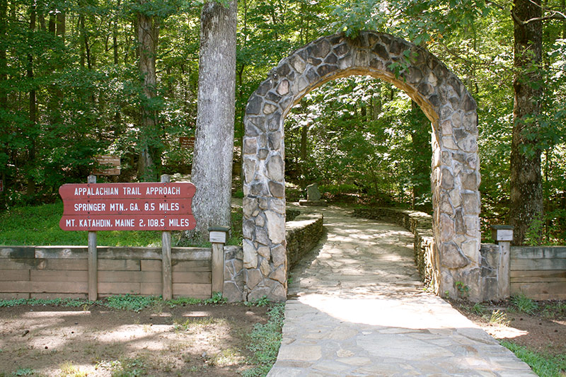
1. The Approach Trail
Start of the approach trail in Amicalola Falls State Park. Photo credit Courtney McGough. CC BY-NC-ND 2.0.
For the majority of prospective AT thru-hikers their first chance to experience a little blue blaze action comes before they even reach mile zero. Starting down in Amicalola Falls State Park the Approach Trail climbs 8.8 miles through the Georgia mountains up to the southern terminus of the Appalachian Trail atop Springer Mountain. It is one of only two options for hikers to get to the AT’s southern terminus, and of the two it is certainly not the easiest. For those hiking north the Approach Trail starts just behind the Amicalola Falls visitors center at the ever famous “arch”. Less than a mile down the trail hikers must traverse the daunting 604-step staircase leading up to the top of the Amicalola Falls. Once atop the falls hikers must still continue on over 7 miles of viewless PUDs to the summit of Springer Mountain. While this blue blaze should be a cake-walk for any hardened southbounder, the Approach Trail can be quite a grueling challenge for the many unseasoned northbounders setting out on their first day.
It’s true hiking an extra 8.8 miles mostly up hill just to get to Mile Marker 0 is a tough sell, so why consider it at all? Well, it’s not like the Approach Trail has nothing to offer. For one, Amicalola Falls are stunning. Even if you don’t wish to hike the entirety of the Approach Trail hiking to the top of the falls and back will cost you no more than 2 miles round trip from the arch. Failing that you could even just drive to the parking lot nearest the falls for an even shorter trip. Either way the falls are well worth your time. It’s also possible for hikers walking the Approach Trail to take it extra slow by splitting the journey over two days by staying at the Len Foot Hike Inn. While not cheap, the Hike Inn offers rooms, warm showers, a family style dinner & breakfast, small resupply opportunities and is exclusively accessible via the Approach Trail. A 1 mile green blazed trail connects with the Approach just shy of 5.5 miles allowing any hiker willing to pay for a reservation to make the blue blaze’s mileage that much easier to handle.

View of Amicalola Falls by Michael Hicks. CC BY-NC-ND 2.0. CLICK TO ZOOM!!!
However, those who decide to hike the Approach Trail tend to do so for reasons beyond tangible rewards. Contrary to most other blue blazes there are folks of the opinion that thru-hikers must hike the Approach Trail despite the fact it isn’t an official part of the AT. Whether or not thru-hikers should hike this trail has been, and still is, a widely debated subject in the community. So much so that AWOL even has a dedicated page in the guidebook for the Approach Trail’s elevation profile. For some the idea of skipping the Approach Trail is akin to yellow blazing. It’s viewed as a sort of proving grounds and that conquering this inaugural challenge is an AT rite of passage. Yet, for others it’s viewed as a simple waste of time. Of course, which of these categories you find yourself relating to more is entirely up to you.
2. Long Creek Falls

Photo credit Matt Malone. (CC BY-NC 2.0).
Just a few miles north from Springer Mountain hikers will find the the popular Georgia day-hike destination known as Long Creek Falls. The falls are nestled within the Three Forks creek valley where Long Creek, Stover Creek, and Chester Creek converge together. For nearly a mile the AT parallels Long Creek just north of USFS 58. At Mile Marker 5.2 hikers come to a three-way junction with the AT, Benton Mackaye Trail and the short spur trail leading down to the falls. It takes no more than a 0.1 mile jaunt down this blue blaze for hikers to reach the two-tiered, 50 foot waterfall. The falls themselves consist of an upper and lower cascade beautifully framed by the valley’s hemlock and rhododendron. Beautiful as they are Long Creek Falls are certainly not the grandest falls to be seen along the AT, but that is hardly a worthy excuse to pass them by. For northbounders it will mark the first of many opportunities to slow down and take in all the AT has to offer. For southbounders it’s a chance to escape the Springer tunnel vision to just sit and reflect before rushing into their final moments of their journey. Long Creek Falls are either the first or the last thru-hikers will get to experience on their grand AT adventure (Amicalola Falls notwithstanding), so I suggest not taking them for granted.
3. Virginia Creeper Trail
Photo credit Curt Fleenor. CC BY-NC-ND 2.0.
Perhaps unbeknownst to many thru-hikers is that the famed hiker town of Damascus is traversed by at minimum six major trails besides the AT. Likely the second most famous of these trails is the Virginia Creeper Trail (VCT)–a 34 mile trail running from Abingdon to Whitetop, VA. Considered to be one of the best rail-to-trail paths in the country, the VCT is open year round to hikers, bikers, and even equestrian travel. Have hikers the time, money, and patience for finding a way to traverse the entirety of the VCT during their time on the AT they would certainly not regret it. Local rental and shuttling services can help hikers trade their packs for pedals (figuratively of course) to get them riding along the VCT in no time. Should such a lengthy detour be out of the question it’s still possible for interested hikers to follow a smaller portion of the VCT out of (or into) Damascus instead of the AT.

Cascades along Whitetop Laurel Creek. Photo credit Curt Fleenor. CC BY-NC-ND 2.0. CLICK TO ZOOM!!!
The AT and VCT are actually contiguous at two different points: first between mile markers 470.2 – 470.6 and then again between mile markers 482.5 – 483.2. As a result hikers can choose to bridge the distance between mile markers 470.6 – 482.5 by either traveling the 11.9 miles along the AT or instead walk 11.1 miles along the VCT. Should nearly 12 miles of white blazes be more than you’re willing to skip it’s also possible to split the difference as the AT and VCT also run side-by-side between mile markers 474.7 – 477.0. While not officially contiguous here the trails run so closely to each other it’s possible to find small connector trails bridging the gap.
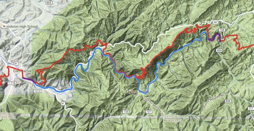
Map showing the relation of the Virginia Creeper Trail (VCT) to the Appalachian Trail (AT)
Red Line: AT
Blue Line: VCT
Purple Line: AT + VCT
As with most alternative paths the difficulty in making this choice will depend upon how much a purist hike matters to you. So assuming that you are open to the idea missing some white blazes there are a few reasons why VCT is worth your consideration. While beauty is always in the eye of the beholder it is safe to say that the VCT is the more scenic route through this area as it’s essentially a river walk. The VCT meanders over and along Whitetop Laurel Creek the entirety of this detour. The trail soothes with the sounds of babbling brooks and dazzles with the sights of numerous small falls and cascades. Also did I mention it’s pretty flat and well graded? Meanwhile the AT travels back up into the green tunnel over numerous PUDs with no real vistas to speak of. However, the AT will also take you past Saunders Shelter should you seek a roof over your head and a privy by your side.
In summation the choice really comes down to whether you prefer the challenge or the scenery. The Creeper Trail makes for an easier, slightly shorter, and ultimately more beautiful walk than what would be experienced on the AT. Whether or not any of this matters is ultimately up to you.
4. Crabtree Falls

The Upper portion of the falls by Andreas Pagel. CC BY-NC-SA 2.0.
Located just a couple miles south of the Priest hikers lies Crabtree Falls–a cascade of over 1,000 vertical feet down into the Tye River Valley. Rather than being one massive drop the falls are made up of a series of five larger cascades as well as numerous smaller falls spread over 2,500 feet (horizontal). Even so the upper cascade’s 400 foot drop is considered the tallest vertical drop in a waterfall east of the Mississippi River. Hikers may reach these epic falls starting at mile marker 826.1, just 3 miles past a spectacular blue blaze at Spy Rock. Here the AT will meet with forest road VA 826. Traveling 0.5 miles down the dirt road hikers will arrive at a small parking lot for the Crabtree Meadows Campground. From here hikers must follow the Crabtree Falls Trail downhill to arrive at the first and tallest cascade of the falls.
Unfortunately there seem to be a few discrepancies to the exact distance of this part of the hike depending on the source you use. According to AWOL’s Guide the upper falls are only 1 mile from the trail head. However, other sources estimate the distance as being closer to 1.4 miles. Either way it’s probably safe to assume that the actual distance is somewhere in between. All in all just to reach the upper falls hikers can expect a 3 mile round-trip at minimum back to the AT. Of course hikers with a more “mileage be damned,” attitude could continue down the Crabtree Falls Trail to view the fall’s remaining cascades as well as several excellent vistas of the Tye River Valley. Whatever your choice you shan’t be disappointed!
5. Humpback Rocks

Photo credit Kenny Howell.
With Spy Rock, the Mau-Har Trail, and Crabtree Falls all within a day’s hike of each other it’s clear the AT surrounding the Tye River Valley in Virginia is already brimming with blue blaze opportunities. Yet, there’s still one more we must add to the pot: Humpback Rocks. This overlook is found just 25 miles north on the AT from Crabtree Falls and a mere 11.5 miles south from the border Shenandoah National Park at mile marker 851.1. A 0.2 mile blue blaze leads hikers off the AT and down to the rocks themselves where they will find a massive, craggy outcropping that is Humpback Rocks. So named for the perceived “hump” they create on the profile of Humpback Mountain the rocks offer spectacular northwestern facing views of the Shenandoah Valley as well as a peek north in to Shenandoah National Park. A nearby parking lot along the Blue Ridge Parkway as well as the Humpback Rocks Visitors Center also makes this spot a popular destination for locals and day-hikers.

Panorama from Humpback Rocks. Photo credit Kenny Howell.
6. Dunnfield Creek Trail

Dunnfield Creek Trail by Jim Lukach. .
Less than 1.5 miles north of the PA/NJ state line hikers will find themselves in the Dunnfield Creek Natrual Area. Moving north the AT passes directly through the area and begins ascending towards Sunfish Pond. However, about a half mile north from the parking lot at mile marker 1295.4 a fork in the trail appears. Hikers may choose to stay left and continue their ascent on the AT or they can veer right onto the Dunnfield Creek Trail (DCT) for what makes a more interesting detour. Both paths will eventually lead hikers up to Sunfish Pond so how is a hiker to choose? The DCT is not a simple out-and-back spur trail, so as with any detour purists will have an easy choice. For everyone else there are some things to consider.
In this instance the AT happens to be the easier but less scenic route while the DCT is the exact opposite. The AT lazily ascends on a wide, rocky path climbing nearly 1,000 feet over 4.1 miles up to the pond. Along the way hikers will find a backpacker campsite at mile marker 1298.7, but beyond that these miles don’t offer much to see until arriving at the pond. Conversely hikers can choose to walk the DCT’s 4 miles along Dunnfield Creek also eventually meeting the AT at the same destination. The two trails eventually converge at a sign and monument just south of Sunfish Pond itself.

Various Trails in the Dunnfield Creek Natural Area. Courtesy of Cliff. CLICK TO ZOOM!!!
The DCT is the tougher of the pair for two reasons. First of all this green blazed detour requires hikers to ford and/or rock-hop across Dunnfield Creek on multiple occasions. Of course, this should be of no concern for seasoned thru-hikers. The real challenge comes towards the northern end of the trail when the DCT finally departs from Dunnfield Creek requiring hikers to ascend 1,000 feet over just one mile up instead of four. So in a nutshell taking the AT will be easier, probably faster, but with much less to see. Alternatively the DCT forces hikers up a pretty steep climb, but not before treating them to the sights and sounds of Dunnfield Creek.
If you’re the kind of person who enjoys having their cake and eating it too it’s possible to get the best of both worlds here. Less than 2 miles north into the DCT hikers will reach a junction with the red-dotted Holly Spring Trail. If you’ve had your fill of the creek and wish to avoid the DCT’s steep ascent it’s possible to take the Holly Spring Trail 0.6 miles and reconnect with the AT at mile marker 1296.6. From there you can continue up to Sunfish Pond at the AT’s more gradual slope.
7. White Rocks Cliff

Northwestern view from White Rocks Cliffs. Photo credit Kenny Howell.
Tromping their way through Vermont hikers will eventually pass through the White Rocks National Recreation Area. Here they’ll find themselves passing by the popular day-hike destination of White Rocks Cliff. A short blue blazed trail sits almost exactly half way between Manchester Center and Rutland at mile marker 1675.1. While the junction for White Rock Cliffs is marked in AWOL’s Guide it is not labeled as having a view for reasons unbeknownst to this author. Please rest assured that a trip down to the cliffs offers multiple views, all of them stunning. Hikers should actually find this spur trail quite hard to miss as one of the largest cairn gardens found on the AT marks the junction. Despite the ongoing controversy regarding the practice of “stone-stacking” this garden has survived the years assuring hikers not miss this Vermont vista. However, should hikers find themselves lost in the garden a small wooden sign at the junction also points to the way to the cliff’s. The spur trail will leads hikers 0.2 miles downhill towards White Rocks Cliff’s stony vista over the valley with the Taconic and Adirondack Mountains nestled in the distance. It’s a perfect place to lounge and lunch before pressing ever onward into the Vermont wilderness.

A massive cairn garden & sign clearly marks the spur trail to White Rocks Cliffs. Photo credit Kenny Howell.
8. Mt. Cube: North Peak

Northeastern view from Mount Cube’s North Peak towards Mount Moosilauke. Photo credit Jeremy Clark with FranklinSites.com Hiking Guide.
When we think of the AT in New Hampshire most thoughts immediately jump to the White Mountains. But it’s not all about the White Mountains you know! There’s that good 45 miles of trail between Hanover and Mt. Moosilauke full of mountains to climb. Sure, their names might not be as cool but they’re still mountains dammit! One of these oft forgotten mountains is Mount Cube. The AT takes hikers up and over Mount Cube’s exposed southern peak where they can enjoy fantastic views of Smarts Mountain just a few miles south. Yet, the humble Mount Cube has much more to offer. Only 0.1 miles north from the mountain’s southern summit the AT reaches a junction with a spur trail at mile marker 1777.4 heading to Cube’s northern peak. A short 0.3 mile walk takes hikers to the peak’s open cliffs with a entirely new vista to enjoy. What makes the north peak particularly spectacular is it provides one of the best views of Mt. Moosilauke short of the Whites themselves. With the epic mountain sitting a mere 15 miles north up the trail Mt. Cube’s northern peak is an ideal place for northbounders to sit and ponder the challenges to come or for southbounders to say their final farewells to the beauty that is the Whites. In this writers humble opinion if you have to pick a peak upon Mt. Cube to sit and relax then take the trail less traveled to the northern peak. But honestly why not just make time for both?

Panoramic view from Mount Cube’s northern peak. Photo credit Matt DiFrancesco. CLICK TO ZOOM!!!
9. Half the peaks in the Presidential Range.

View from atop Eisenhower with views of Franklin, Monroe, Washington, Clay, and Jefferson. Photo credit Kenny Howell.
Now jumping to the Whites… The Presidential Range is the climactic finale of the White Mountains for nortbounders as it contains the five tallest mountains in the entire range. Sure, there’s still technically 20 miles to go over ol’ Wild Cat, Carter Dome, and Mount Moriah before the end, but let’s face it. Finishing the Whites as a northbounder is like sitting through the epic Battle of Minas Tirith before having to drag through a few too many surprise endings. The Presidential Range is comprised of a whopping total of 11 named peaks in little over 20 miles, (Webster, Jackson, Pierce, Eisenhower, Franklin, Monroe, Washington, Clay, Jefferson, Adams, Madison) eight of which are on New Hampshire’s 4,000 footer list. But wouldn’t you know it that the AT actually bypasses the summits of 5 of these 11 peaks?
While still unquestionably beautiful in it’s own right sticking to the AT will cause hikers to miss out on the summits of Eisenhower, Monroe, Clay, Jefferson, and Adams. Fortunately the AT connects to a spur trail for each of these bypassed summits to ensure every peakbagger can get their fill. These spur trails are actually designed as loop trails, meaning they start and end at different points on the AT. Naturally you don’t have to walk the loop if that’s not your style. Those who don’t wish to miss a moment of the AT can hike these spur trails up to their respective summits and then backtrack right down to where they started. Granted this will inevitably net more total mileage while up in the range, but to each their own. The spur trails for each path starts/ends as follows:
- Mount Eisenhower: mile marker 1852.4/1853.0 – approx 0.7 miles
- Mount Monroe: mile marker 1854.3/1854.9 – approx 0.7 miles
- Mount Clay: mile marker 1857.5/1858.0 – approx. 1.2 miles
- Mount Jefferson: mile marker 1859.0/1859.8 – approx. 0.7 miles
- Mount Adams: mile marker 1861.1/1861.7/1862.0
- In the 2015 AWOL’s Guide a loop trail for Mount Adams is not specifically labeled. However, trails that make up an “Adams loop” are identified under their respective names. The southern most intersection is found at Thunderstorm Junction (1861.1) where hikers follow Lowes Path 0.3 miles up to the summit. Hikers can hike 0.6 miles down from the summit via the Air Line Trail (1861.7) back to a junction with the AT.
In most instances the summit loop trails are of comparable mileage to the bypass routes on the AT usually only differing by tenths of a mile if at all, but they will be inherently more strenuous due to the added elevation of the peaks (particularly Adams). Particularly daring hikers may feel like tackling the Presidential Traverse, but why rush yourself through what is undeniably one of the most incredible sections of the AT? Whether you do it in a day or take it slow the Presidential Range (in good weather) offers some of the most awe-inspiring views thru-hikers will experience. Taking a trip to every summit peak will only enhance it. So why anyone would want to bypass any of these summits is just a question that I can’t really answer.

View from Mount Clay looking towards Jefferson, Adams, Madison. Photo credit Kenny Howell.
10. Sugarloaf Mountain

Blue blaze junction with the AT leading up to Sugarloaf’s summit. Photo credit Rebecca Sudduth. Increased contrast and decreased brightness from original. CC BY-NC 2.0.
Nestled between Spaulding Mountain and the Crockers the 4,249 foot Sugarloaf Mountain sits as Maine’s third highest mountain. Dwarfed only by Mount Katahdin’s Baxter and Hamiln Peaks Sugarloaf Mountain may be today most well known for the ski resort which resides on its northern slope. However this mountain holds an important place in AT history. In August of 1937 the final section of the Appalachian Trail was completed to Sugarloaf Mountain ultimately connecting it together as a continuous footpath! At the time of it’s completion the AT traveled directly over the summit of the mountain until in 1976 when the trail was relocated off the summit due to conflicts with the ski area. Yet, hikers can still retro-blaze their way towards the summit as the original AT path still exists today as the Sugarloaf Mountain Trail. The AT intersects with this blue blaze at mile marker 1990.5. From the trail junction hikers can follow the rocky path 0.6 miles up to the summit. These days Sugarloaf’s peak has suffered more development than it’s neighboring peaks due to the ski area, but between the few fenced in buildings and radio towers Sugarloaf offers some of the best views in Maine south of Mount Katahdin. Also before following the trail back down to the AT hikers can find a plaque commemorating those who aided in incredible accomplishment of stitching together the entirety of the AT–an accomplishment worthy of a hiker trash salute.

Panoramic view from atop Sugarloaf Mountain by Wolftone. CC BY-NC-SA 2.0.
And that’s a wrap!
In this series we’ve now discussed more than 40 blue blazes that you can find along the Appalachian Trail. What are your favorites? Are you going to make a point to visit some of these trails along your own AT journey? Did we miss any of your favorite trails you wish we’d talked about? Head on down to the comments and let your voice be heard!

This website contains affiliate links, which means The Trek may receive a percentage of any product or service you purchase using the links in the articles or advertisements. The buyer pays the same price as they would otherwise, and your purchase helps to support The Trek's ongoing goal to serve you quality backpacking advice and information. Thanks for your support!
To learn more, please visit the About This Site page.

Comments 4
wow what a terrific resource!
Thanks so much for putting this list together for us adventurers.
And I read all 4 pages from my office cube!
Thank you for these articles. A great resource for planning my upcoming thru. Mount Abraham in Maine is another must do blue blaze. Located 4 miles south of Sugarloaf, a 1.7 mile Mt. Abraham Side Trail has you hike/scramble up the second largest alpine zone in Maine behind Katahdin. At the top you are rewarded with 360 degree views, often to yourself, as this mountain is a little more remote. Some may scoff at the 3.4 mile round trip spur.