 ">
">
10 Spectacular Blue Blazes (and Other Short Side Trails) on the Appalachian Trail [Part 1]
I’m not here to tell you how to hike your hike, I’m just here to beg of you just one thing; please, please, PLEASE consider taking some of the short little side trails to the outlooks, waterfalls, fire towers, landmarks, etc that in many cases are just mere steps off of the Appalachian Trail. I can’t tell you how many times I had this conversation at the end of the day at a shelter while on the AT:
Hiker: “Did you take the spur trail to XYZ view point today?”
Me: “Yes, it was incredible. I spent an hour there sunbathing and drying my tent out. The view was amazing.”
Hiker: “Oh man, that sounds nice. I skipped it. Can I see your pictures?”
Me: “Sure. Whaaaatttt???”
There are many opportunities to take spur trails / blue blazes to various outlooks/points of interest most of which are noted in the various AT guide books. It is true that all of them are not spectacular and that there will be days when you are high up on a ridge and completely socked in by the clouds meaning the only view you are going to get is the one of the inside of a cloud (think big glass of milk). But for the most part, it is worth your while to take the extra steps to see some of the most beautiful sites there are to be had along the trail. These spots provide a good place to take a break and relax. If you’re rushing through the day just to be the first to reach the shelter then you are missing the point. Of course that’s just my opinion, HYOH of course. Here are some of my favorites from my hike (all mile markers are taken from AWOL’s 2014 Northbound A.T. Guide):
1) Charlies Bunion
The south end of the Charlies Bunion Loop Trail is found at mile 210.7. It is just a short 0.1 mile west to the Bunion which provides extensive views of the Great Smoky Mountains National Park. I arrived there early in the morning so there were just two other people I had to share the spot with. Perhaps I am so fond of this spot because it was one of the only clear days I had while making my way through the Smokies.

Standing on Charlies Bunion, mesmerized by the steep drop-offs into the ravine below
2) Jones Falls
At mile 397.7 in Tennessee you will arrive at a junction that poorly marks the spur trail to Jones Falls. Follow the blue blazes and after 0.1 mile east you will be standing by the side of a magnificent waterfall. Heed warning to signs and keep your distance (many of you will be tempted to bathe here, I was too, please don’t though). Take off your pack, pick a rock, sit back and relax.

Jones Falls

My dorky self sitting in front of the falls to show you just how big they are
3) Dismal Falls
They certainly aren’t massive but they certainly aren’t dismal either. The side trail to Dismal Falls (0.3 west) is found at mile 607.8 in Virginia. These falls have it all; a swimming hole at the base, lots of flat ledges for laying out wet tents and clothes, and some nice little tent spots too. I wish I had camped here but instead took the opportunity to eat a nice long lunch while I dried out my soaking wet tent from the deluge the night before.

With a nice swimming hole at the base and lots of broad sunny ledges surrounding it, Dismal Falls is a winner
4) Kelley Knob
At mile 667.9 in Virginia you will reach a simple little sign on a tree that says “view.” Following the blue blazes will bring you to an open grassy spot with a fire ring and some overgrown trees. Many hikers I knew thought it was another “outdated” and overgrown view point and turned around and continued on their way. Look carefully to the right and you will find an obscured herd path which weaves through some overgrown brush but emerges to a breathtaking vista. It is a great spot to tent but just remember there is no water up there so plan accordingly.
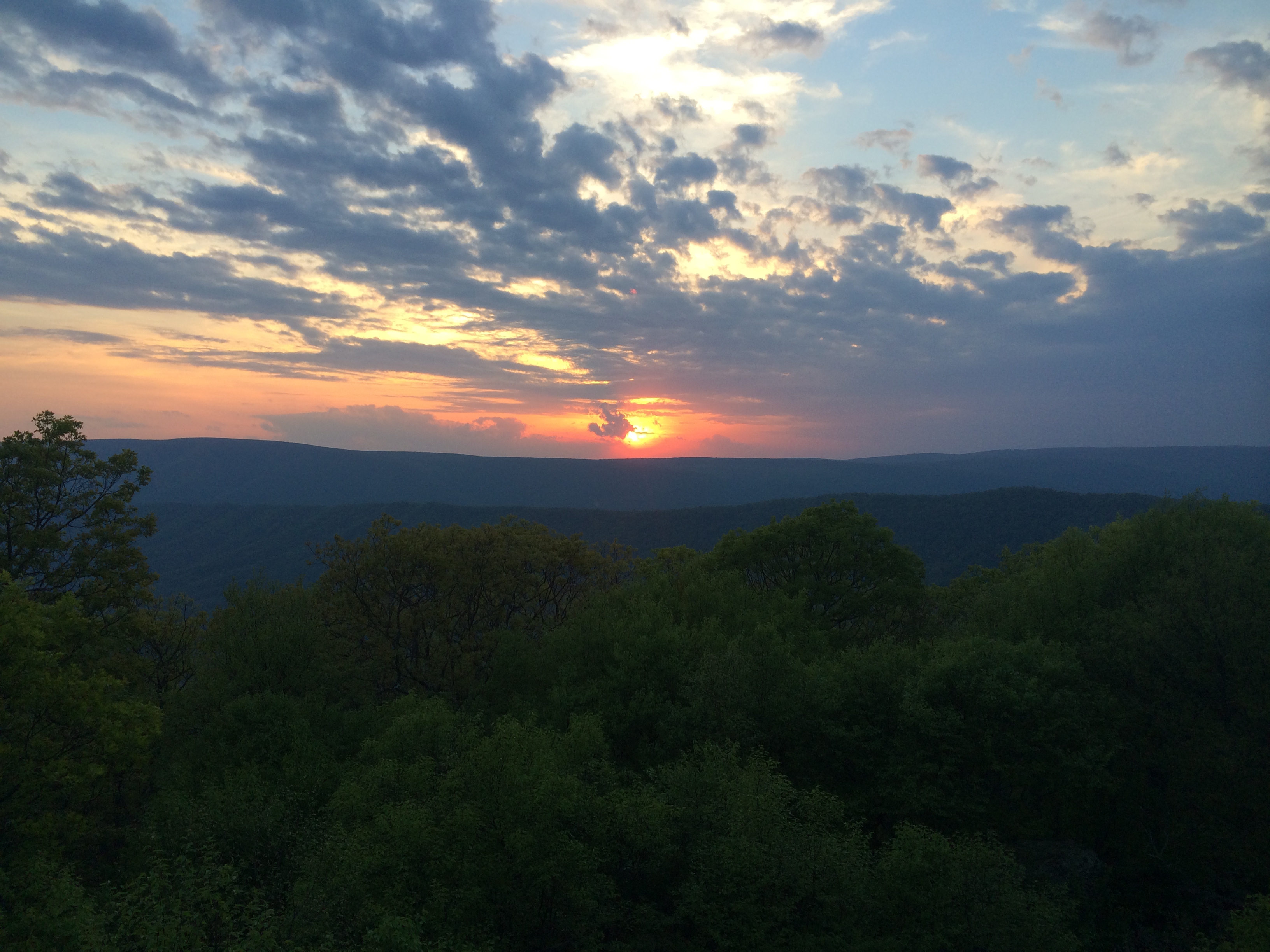
Sunset from Kelley Knob
5) Anthony’s Nose
As it turns out, New York City isn’t the only crazy busy place in the state of New York. I went through the Harriman Park/Bear Mountain area on a weekend so needless to say, there were a s*** ton of people everywhere. The side trail to Anthony’s Nose, found at mile 1400.9, is a lengthy 0.6 miles but well worth it to see the view of the Hudson River and the Hudson River bridge that you will have just walked over. There were a few people up there but far less than the masses I had just walked through. It was a nice spot to decompress for a bit.

View of the Hudson and the Hudson River Bridge from Anthony’s Nose
6) Upper Goose Pond Cabin
Upper Goose Pond Cabin is located 0.5 miles west off of the AT in Massachusetts at mile 1544.6. It is owned by the AMC and run on a volunteer caretaker basis. There is no charge to stay there but donations are encouraged and appreciated. Even if you arrive there in the middle of the day and still have plans to press on you should take the detour and spend some time at the cabin. There are two docks and a sandy beach area for swimming. There are also canoes which you can take out on the pond (I can’t tell you how good it felt to give my arms a little workout by paddling around). If you do choose to spend the night there is a bunk room with mattresses and a common room with a wood burning fire place and a huge assortment of board games and books to choose from. And, if you are nice, the caretaker will make you pancakes and coffee in the morning (that is completely up to them you should not go there with the expectation that they will make you pancakes in the morning). This place is truly a gem.
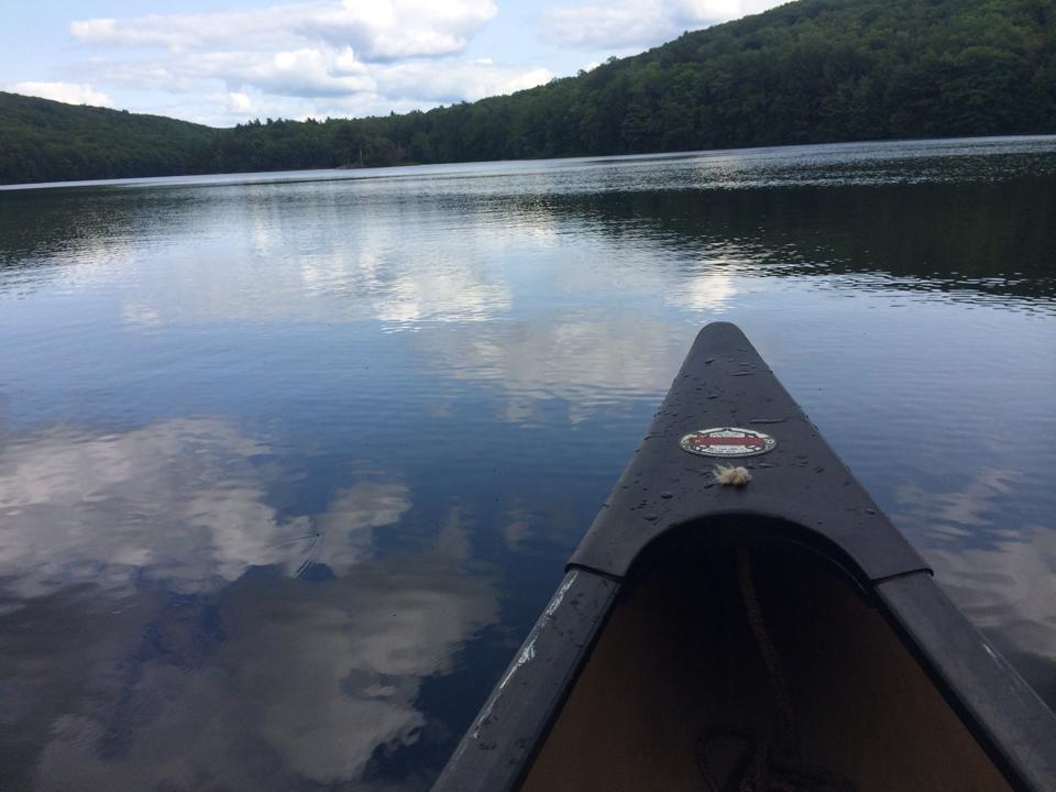
Paddling around Upper Goose Pond on a beautiful afternoon
7) Killington Peak
At mile 1690.7 in Vermont you will come to the famed Cooper Lodge Shelter. There is a trail behind the shelter that leads up to the summit of Killington. The trail is only 0.2 miles but it is a steep climb so you may want to leave your pack behind at the shelter. Be warned: if it’s mountain top solitude you are searching for on this day then this may not be the side trip for you. There is a tram on the other side of the mountain that brings people up for the views and for the restaurant near the summit (this is a win if you ask me). Still, the views are nice and if you are a north bounder it will be the first 4,000 foot summit since Virginia and if you are south bound it will be the last until Virginia. If you stay at the Cooper Lodge Shelter, Killington Peak would undoubtedly make an excellent spot to watch sunset or sunrise.

I wish this picture did the view justice…you’re just gonna have to take my word for it and head up there and see for yourself!
8) The Bonds
Now this is by no means a short side trip but it is, on a nice day, a truly spectacular side trip through some of the most remote wilderness in the White Mountains. This side trip begins at the junction of the Appalachian Trail (Twinway) and the Bondcliff Trail at mile 1828.0 and travels by West Bond Mountain, Mount Bond, and Bondcliff Mountain. From the junction you would take the Bondcliff Trail (this is also the trail that leads to the Guyot Shelter spur) to the West Bond Spur 0.8 miles. It is then 0.5 miles up to the summit of West Bond. If you are staying at the Guyot Shelter, West Bond is a must for sunset or sunrise or both. Once back at the junction of the West Bond spur and Bondlciff Trail, continue another 0.5 miles to the summit of Mount Bond. From here until the summit of Bondcliff is a mostly open ridge walk in the alpine zone (1.2 miles). You will have views of the most remote part of the Pemigewasset Wilderness and Hellgate Ravine. Roundtrip from the AT is 6 miles. Yikes! I know! It is a rugged 6 miles but if you think you may never be back at this spot again in your life, it may be worth the detour. If you are staying at the Guyot Shelter is is definitely worth at least the small trek to West Bond for the amazing views.

Looking at Bondcliff from the summit of West Bond

Looking over at the summit of Bondcliff from Mount Bond
9) Zeacliff
This one is simple. At roughly mile 1831.0 in New Hampshire you will come to a little wooden sign that says “view.” Follow the herd path 20 yards or so and you will find yourself at one of the most spectacular outlooks in the White Mountains. All the way to the left you will be able to see Mount Washington (assuming it’s not in the clouds like it is 65% of the time). Down to the left and closer is the heavily eroded Whitewall Mountain which you will later be walking under as you make your way north on the AT along the Ethan Pond Trail. In front is the Pemigewasset Wilderness with Carrigain Notch and the massive Mount Carrigain looming behind in the distance.

The view from Zeacliff, one of the best in the White Mountains
10) Old Speck
Less then one mile after the Old Speck Shelter and Campsite in Maine, you will reach the junction to the side trail to the summit of Old Speck (mile 1914.6). The side trail which is 0.3 miles, leads to an observation tower on the summit. From the tower you can see down into Mahoosuc Notch, Grafton Notch and over to the Baldpates which you will be climbing shortly. I arrived up there early in the morning and met a section hiker who had spent the night up there and awoke to an amazing sunrise. Although I was quite happy with the astounding views of undercast I had, I was a bit jealous that I didn’t get my butt up there for sunrise.
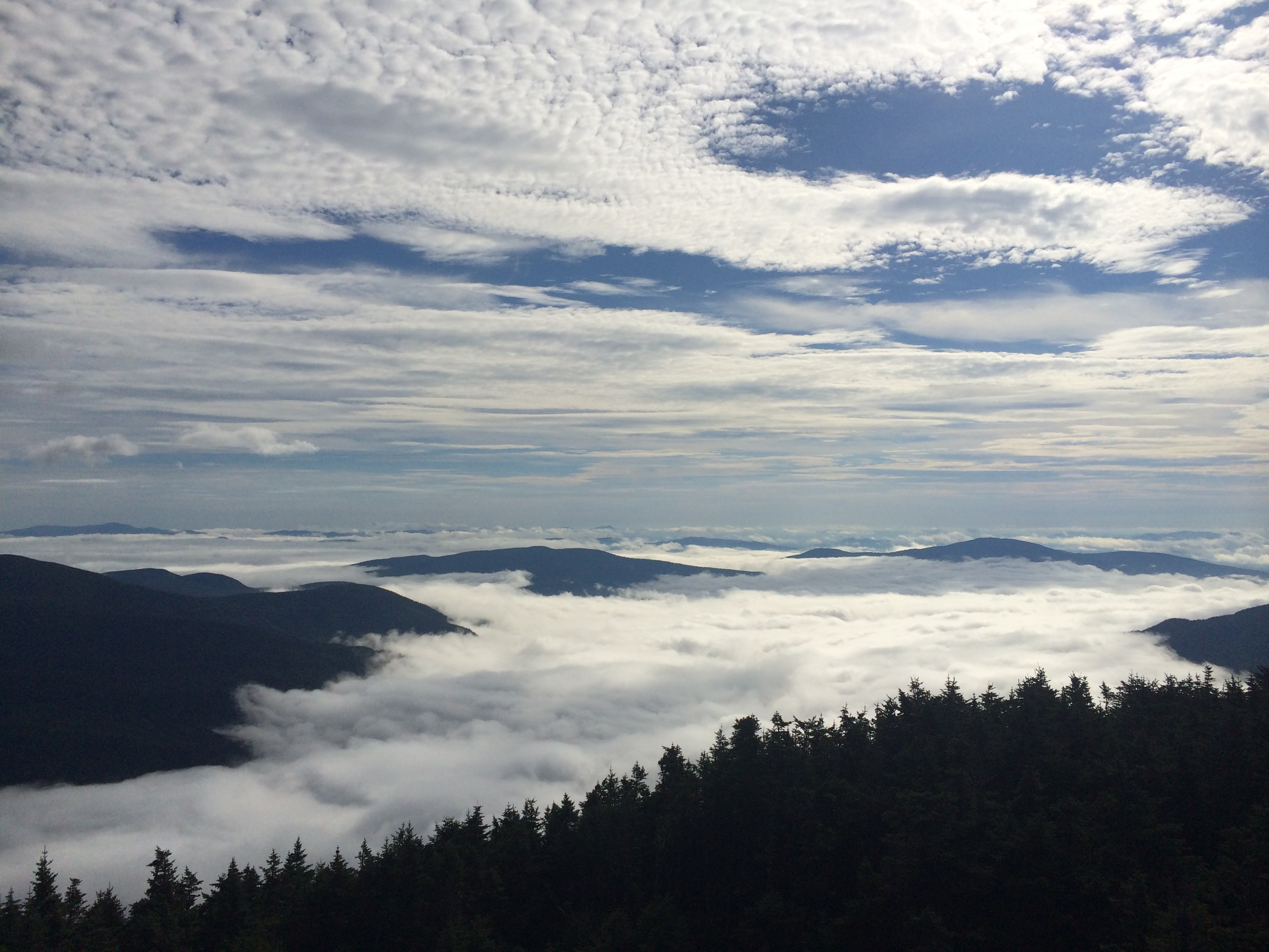
Early morning undercast fills the valley below
There you have it. Some of my favorite side trails to views, points of interest, waterfalls, etc while on the AT. I have many more and there were a handful I didn’t take probably due to bad weather or the occasional time restraint (having to make a shuttle pick-up got me a couple of times). I hope you don’t think I am giving away any secrets here because most of these are listed in all of the guide books. I just hope that when you are out there thru-hiking the Appalachian Trail or any trail for that matter, that you will think of this post and maybe get a friendly push to go explore a little more.

This website contains affiliate links, which means The Trek may receive a percentage of any product or service you purchase using the links in the articles or advertisements. The buyer pays the same price as they would otherwise, and your purchase helps to support The Trek's ongoing goal to serve you quality backpacking advice and information. Thanks for your support!
To learn more, please visit the About This Site page.

Comments 13
Your mileage is not consistent with the 2015 AT Guide
In her defense, she does say all mile markers are from the 2014 guide, and they would be just slightly different for this year.
I confess I missed that…
Thanks for posting this Whitney! This is exactly what I’m hunting around for right now– I want to take side trips and do some blue blazing, so thank you! I’ve made notes in the guide to remind myself to check this stuff out 🙂
There is a major omission here. Gulf Hagas ( https://en.wikipedia.org/wiki/Gulf_Hagas ) just before White Cap @ 2106.4 (AWOL 2015) is an absolute must see. It’s a 7 mile loop of beautiful waterfalls with some great swim holes. You only need to hike a little bit to hit the first couple though, so no need to walk the whole circuit.
in what What book do I find the blue trail info to get me back to the AT. How many miles is average for a day. Some shelters do not conform to miles so do you just pull over and tent
Thanks for mentioning the Bonds. We are not thru hikers, but my daughter and I have hiked 48% of the White Mtns . I have actually suggested this detour to a few folks. Zealand is a little easier, just a few moments detour.
Another good one is the Gulf of Hagas trail in the HMW