 ">
">
Chinook Trail – White Salmon To Lyle, WA
White Salmon Zero Day
Bailing at Panther Creek, and hitching and shuttling to White Salmon, gave me an unexpected zero day in White Salmon. While I wasn’t too sore from the trail yet, it dumped rain all day long so it wouldn’t have been a pleasant day of hiking. The day was used to relax and get a few things done. Quick shower, then a walk uphill into town to forward my resupply box to Hood River. Then I went over to White Salmon Baking Company, a cool artisan cafe/bakery. I enjoyed cup after cup of coffee and an egg/cheese/mushroom/herb scramble on top of a thick slice of bread. The rain come down in buckets as I read Carrot Quinn’s latest zine and charged devices—capped it off with a gooey chocolate chip and walnut cookie. The rest of the day was spent picking up vitamins at the funnily named Hi-School Pharmacy, having a big lunch/dinner at Everybody’s Brewing, and then walking back to the RV park in the rain.


Back on the Trail – Crossing from Western Washington to Eastern Washington
The next day was overcast and in the 50s to start; perfect hiking weather. I packed up camp and hit the road for a one-mile road walk to Bingen to hit Carmen’s for breakfast. After enjoying a big omelet, hash browns, coffee, and OJ, I started the uphill climb to White Salmon, where the actual trail walking for the day started. Behind a fairly large hospital was the trailhead for the Millennium Trail, which switchbacks up the Columbia River side of Burdoin Mountain. It was a scenic hike up through oak trees, with views of White Salmon, Hood River, and the Columbia opening up nicely. I didn’t like the thousands of acorns that I had to step on, but worse was the wet grass that soaked my boots and socks.

At the top I encountered a “No Trespassing” sign with a couple of dogs barking behind it—but the trail continued beyond the sign. What to do now? I saw the trail continue to climb, but not in the direction I needed to go. I looked a bit more carefully and saw that the dogs were behind an invisible fence. The sign just pertained to the land where the dogs were standing, not the trail. I opened the gate and was able to continue forward.
Atwood Road Traverse to Coyote Cliffs
The Millennium Trail meets up with Atwood Road, which, despite the name, is really just a single track trail that’s too narrow for vehicles. It’s a beautiful forest trail—I didn’t know at the time, but it was really the last nice forest trail I would walk until I reached the PCT on the Oregon side.
Atwood Road hooks up with the Coyote Wall area, a network of trails popular with mountain bikers and hikers. It’s also where the trees thin, the grass is yellow/gold and the clouds part—I was now entering Eastern Washington. The temps also rose about 15 degrees—time to hook up the sun umbrella for the first time. It took 45 minutes, but I finally figured out how to attach it to my pack—should have tried at home first. The panoramic view from here was amazing—I could see a 20-mile stretch of the Columbia River. All the way to Lyle—my end point for the day. It seemed so close, but it really wasn’t.

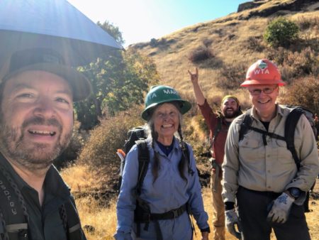
As I snaked down the mountain, taking lots of photos along the way, I saw a WTA (Washington Trails Association) crew doing trail work. Needing a break, I stopped to say hi for a bit. The leader of the crew, Tom Griffith, is also a volunteer with the Chinook Trail Association, so it was great to talk to him about how the hike was going so far. We took a few photos, but I had to continue on so I said goodbye and made my way down to the bottom of the Coyote Wall section. This is where I met up with Old Highway 8, which starts off as an abandoned road (probably due to the crumbling cliffs above it). It then meets with an active section of the highway, which would take me all the way to Lyle. Yep, I had about eight miles of road walking to look forward to.
Road Walk to Lyle
This was my first big road walk of the Chinook Trail and I was curious to see how it would go, as I had longer road walking stretches ahead of me. No one throws on a 30-35 pound pack and purposefully trains on concrete roads—it’s not fun and it just isn’t good for you. Still, for this trail it is a big part of it. Thankfully, this stretch is quite scenic, passing Catherine Creek Park, farmland, cows, wineries, and amazing views of the Columbia River. The shoulder wasn’t very wide, which was OK since there was little traffic on this road (other than people going to the wineries).
I made it into Lyle about 6 p.m. and checked in for my first hotel stay—at the Lyle Hotel. It’s really the only option in town, but it’s a great place to stay. The owners are super-nice and the restaurant is excellent. They asked if I’d like a beer brought to my room as I unpacked and took a shower—how could I turn that down? Mentioning that I liked IPAs that’s what they brought me. Ironically, it was from a brewery in my town of Bellingham. Unfortunately, it’s from a brewery I am boycotting—Melvin Brewing, whose “bro culture” and extreme anti-women attitudes should not be encouraged by drinking their beer. I appreciated the gesture, and drank the beer not knowing where it was from, but after talking to the owners they said they would no longer carry their beer.
I spent the rest of the evening enjoying a nice meal, hanging out with the owners, and making a new friend—a fellow hiker and outdoor enthusiast named Elmo. Unfortunately, as the evening drew to a close, I started sneezing and coughing—was this some sort of illness coming on? Nooooo…

This website contains affiliate links, which means The Trek may receive a percentage of any product or service you purchase using the links in the articles or advertisements. The buyer pays the same price as they would otherwise, and your purchase helps to support The Trek's ongoing goal to serve you quality backpacking advice and information. Thanks for your support!
To learn more, please visit the About This Site page.
