 ">
">
10 Things 2020 CDT Hikers Need to Know
Planning a CDT thru-hike this year? Don’t know where to begin? Start here! We’ll cover the basics, from getting to and from the trail, what type of navigation to use, potential for snow and wildlife precautions, and how you can support the Continental Divide Trail Coalition.
1. Getting to/from the Northern and Southern Terminus

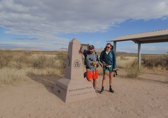
Southern Terminus
Whether you are NOBO or SOBO, getting to and from the Southern Terminus requires some planning. If you’re starting at the Southern Terminus, check out this article for all the information you need about getting yourself a shuttle to the Southern Terminus of the CDT, and information about the alternate termini on the southern border. If you’ll be finishing your hike here, you should call the CDTC to arrange a shuttle pick-up. More info here. If you do not arrange for a shuttle, then you should factor in another 20 miles or so of hiking to the highway to get a hitch.
Northern Terminus
There are two termini on the northern border: Waterton and Chief Mountain. If you’re starting your hike here, beginning at Waterton means entering Canada to start your hike. Similarly, finishing here means either hiking back or entering Canada. If that’s not doable for some reason, you can drive (or hitch) to/from the official border crossing at Chief Mountain and start/finish your hike at the border without entering Canada. Sometimes high snow prevents SOBO CDT hikers from taking the Waterton route. Similarly, sometimes fires prevent NOBOs from going to Waterton. You’re in Glacier, so both routes are beautiful.
2. Maps and Navigation

The CDT is more remote and less crowded than the other long trails. On a trail like the PCT, the most-traveled path is usually the right one. The opposite is true on the CDT. The moment you space out and start enjoying the well-established trail you’re walking on is the moment you are probably on the wrong trail. It takes a little more work to keep from getting off-track on the CDT, and pretty much all hikers today rely on GPS as their primary navigation source. However, electronics fail. Carrying paper maps is still recommended, particularly if you will be alone or in high-risk areas. With that said, if nothing else, a NOBO should carry paper maps at least starting in the San Juans—their first taste of high altitude, persistent snow, and exposure on the CDT—and decide from there how they feel. A SOBO should carry maps from the start, especially if there is still snow on the ground. Feel it out from there and decide how to proceed. For a little more information on the various maps available, check out my CDT Alternates Guide.
3. Permits
National Park Permits
All the national parks along the CDT require permits for camping. You must get an individual permit for each park. Planning helps, but walk-in permits are not terribly hard to obtain. While the rules around permitting can seem overly stringent, most rangers are very helpful and accommodating to thru-hikers.

Glacier
Your most complicated permits will likely be Glacier. If you’re so inclined, you can make advanced permit reservations online starting March 15. Please note that with advance reservations, the maximum daily mileage allowed is 16 miles per day. Check out the map! The CDT is the Blue Line, and the campsites are clickable to obtain availability information. Then you can head HERE to fill out an application.
If you’re SOBO and want to get a walk-up permit, head to the St. Mary Visitor Center before you start your hike to obtain a permit. If you’re NOBO and want to get a walk-up permit, hike into the park 10.5 miles from East Glacier to Two Medicine. You can camp permit-free at this front-country campground, and visit the ranger station to obtain your permits for the remainder of your hike. For both NOBOs and SOBOs, you’ll find that Glacier is a very popular backpacking destination, very busy in the summer, and backcountry campsites do fill up. Flexibility is key, because you may have to hike fairly short and/or fairly long days.
Yellowstone
It’s possible to hike through Yellowstone staying at the front-country sites at Grant Village and Old Faithful Village by hiking (in NOBO order) a 27-mile day (then hitching within the park), 25-mile day, and 18.5+-mile day. This would avoid the need for backcountry permits.
Because getting an advance reservation at Yellowstone isn’t permitted over the phone or via email, it is not feasible for most thru-hikers to get advance reservations. That means the easiest way for a thru-hiker to get a permit is in person. If you’re SOBO, you can hike 18.5 miles into the park to Old Faithful Village to get a permit. If you’re NOBO, you can hitch from Dubois into the park to get your permit. Or, you can hike in 27 miles and hitch to Grant Village. Or, you could try your luck over the phone.
Rocky Mountain National Park
The CDT through RMNP is 25 miles, starting or ending at Grand Lake to the south. Camping in the park requires a permit as well as a hard-sided bear canister. Because this is the only part of the CDT with this requirement, most thru-hikers avoid staying overnight in Rocky Mountain, thus avoiding the need for permits or bear cans. There is also an alternate that bypasses the park altogether.
Other Permits
New Mexico State Lands Permit
This $35 permit is required for recreating on state trust lands in New Mexico. You can apply for this permit on the CDTC website, where you can also view an interactive map showing the various state trust lands in the state. Your permit is valid for one year.
Blackfeet Reservation
Any recreation (including hiking) on Blackfeet Reservation requires a permit. The CDT crosses reservation lands for a few miles bordering Glacier National Park. Get your permit here.
Indian Peaks Wilderness
The Indian Peaks Wilderness lies between James Peak and Grand Lake and requires a permit for camping. The CDT tends to skirt the wilderness boundary, only entering the wilderness for a few miles. Avoid camping in the wilderness and you avoid the need for a permit. If you do plan to camp in the wilderness, go here for your permit.
Wilderness Self-Service Permits
Some wilderness areas have kiosks for free (but still required) self-issue permits.
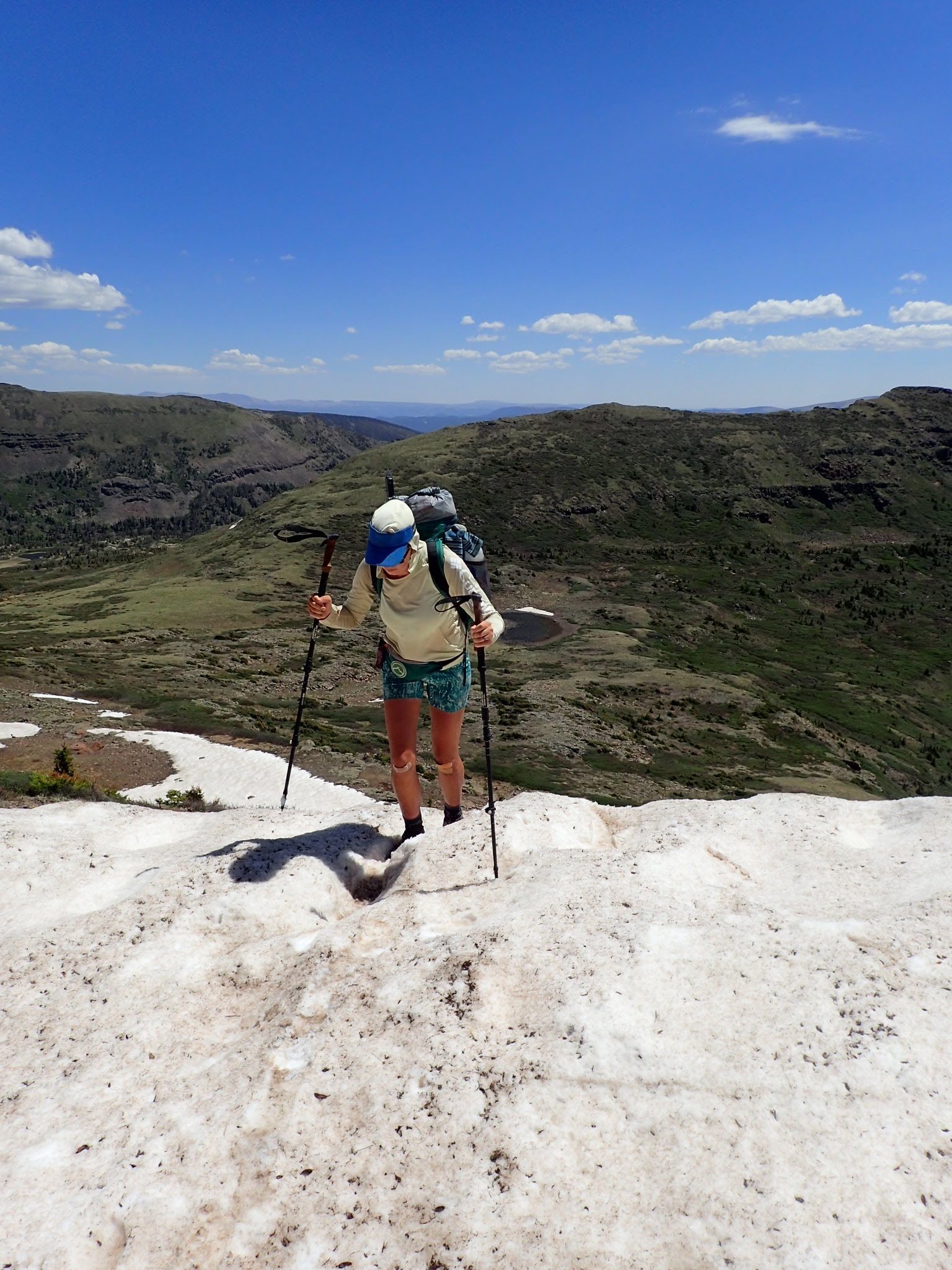
4. Snow
It’s still too early to say how the winter is going to play out, but it’s forecasted to be an average year. Because the weather window is a little tighter on the CDT, you should be watching the weather to determine your best start date and best direction of travel.
Early June in Colorado, after a below-average snow year.
NOBOs
Even in below-average snow years, the San Juans will have persistent snow into June, and you’ll want to get your ice axe and microspikes in Chama. In above-average years, even Northern New Mexico will have snow lingering into June, and you might want to get snow gear as early as Cuba. On an average year, the recommended entry date for the San Juans is around June 1.
SOBOs
Your start date will be determined by conditions in Glacier. Most SOBOs start their hike from mid-June to early July, and usually there will still be some snow to contend with in Glacier. Bring your ice axe and microspikes to start the trail.
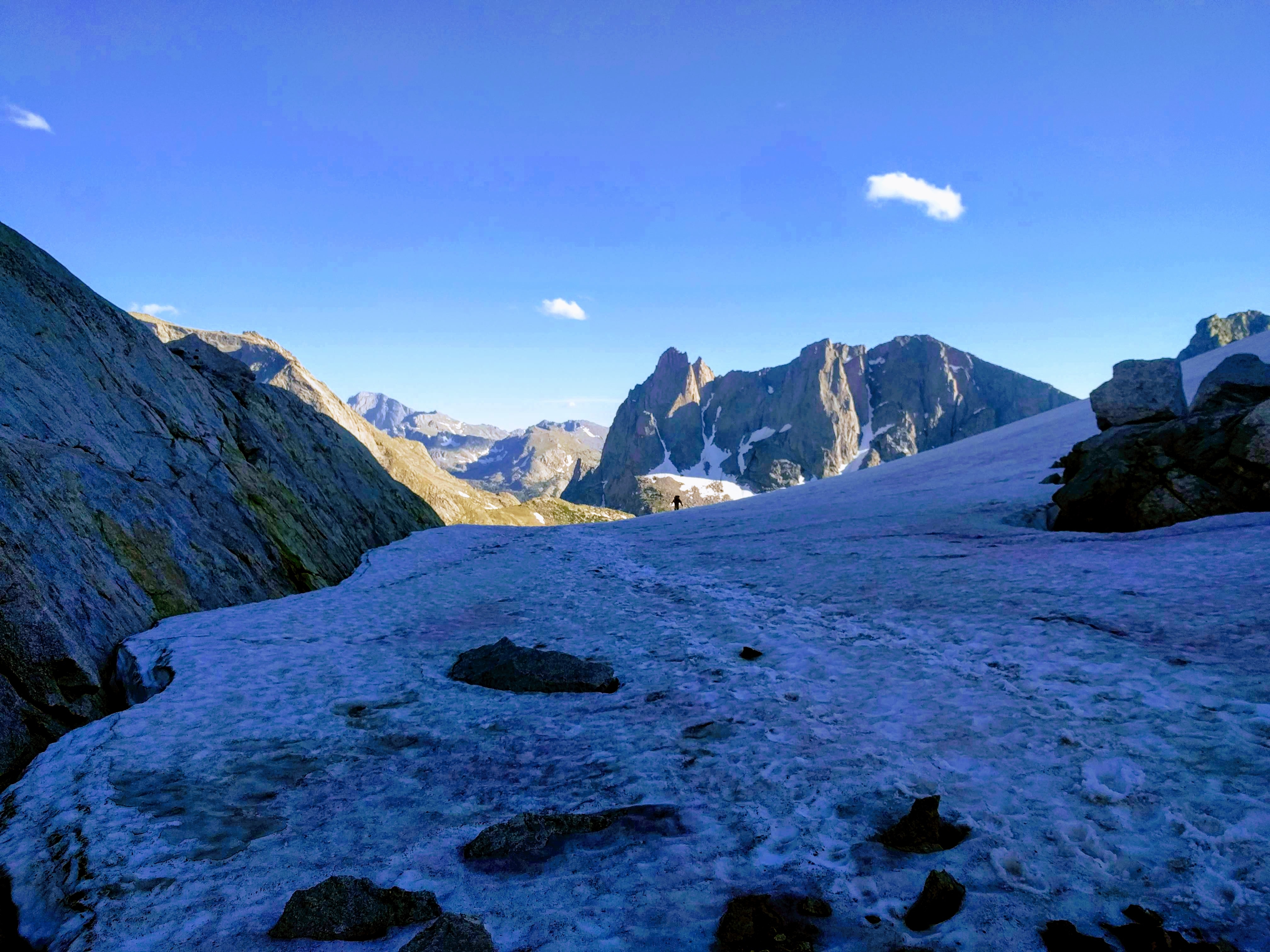
Mid-July in the Winds.
In high snow years, many hikers will flip-flop. There are several ways to do this, but one of the more popular methods is to head north through New Mexico, then flip to the Canadian border and head south. Often, hikers who have started too early find themselves having to put their hike on hold for a few weeks while they wait for the snow to melt.
5. Fires
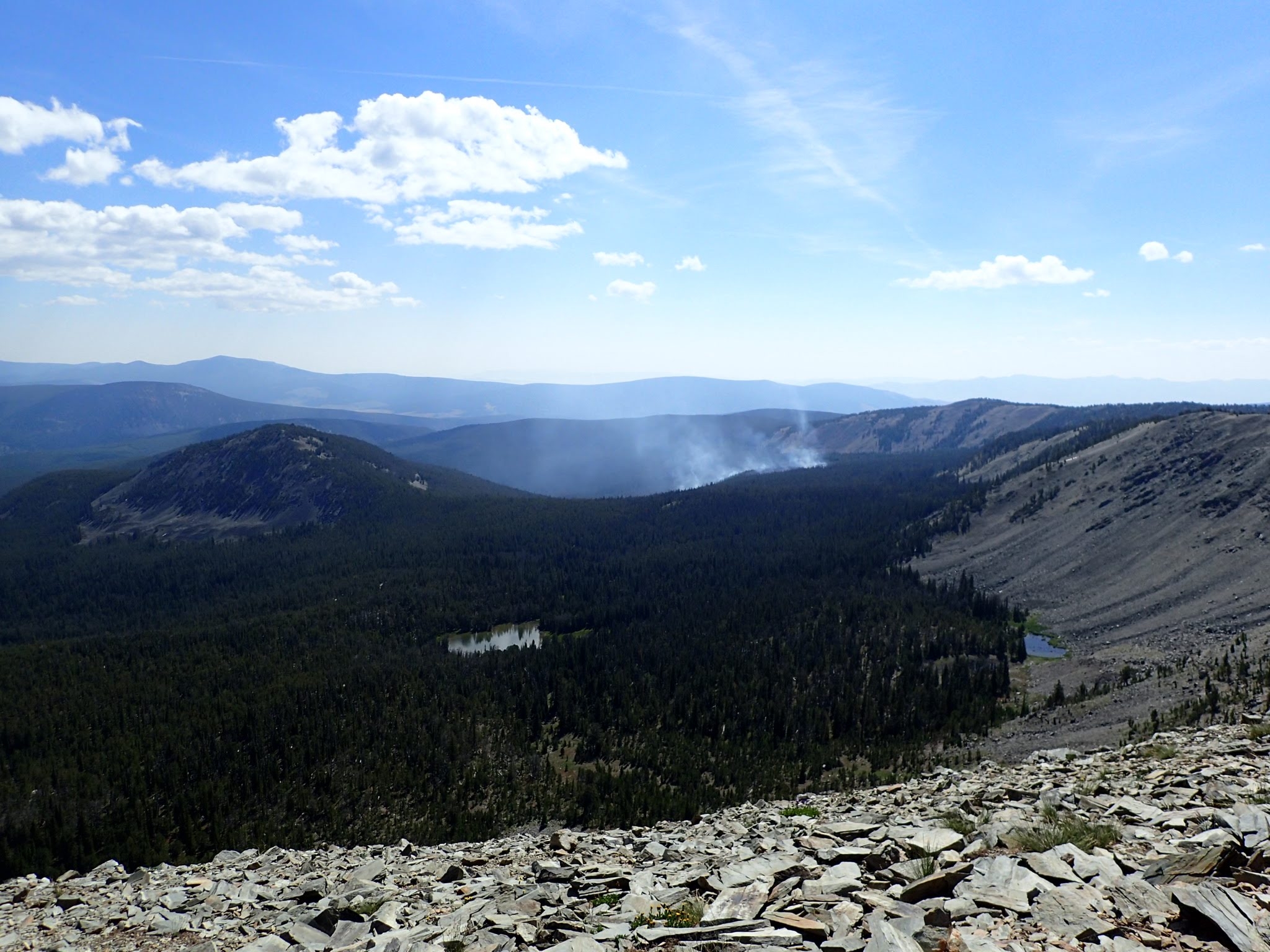
We hiked past this fire before we heard any news of it. Days later it crossed the trail and forced hikers behind us to find alternates.
Is it even a thru-hike if there isn’t a fire to deal with? Fire season in the West is getting longer, and every year wildfires are getting larger and more destructive. Because the CDT crosses more remote areas than other trails like the PCT, and perhaps because it is less crowded, information about fires may not be as rapidly available as compared to other trails such as the PCT. Make sure to stay tuned to the CDTC for updates, but if you see smoke or fire activity, stay alert. I highly recommend this site for current information on fires. Be safe and don’t hike through fire closures. Pull out some maps and find yourself an alternate route.
6. Bear Safety

Bear spray is useless buried in your pack. It should be readily accessible at all times.
The entire CDT is in bear country. The southern half of the trail is black bear country, the northern half is also home to grizzly bears. Grizzly territory roughly begins (or ends) with the Wind River Range. Between Canada and the Winds, you’ll want bear spray accessible at all times and the ability to hang your food.
Hiking
Hiking in grizzly country can be intimidating, but it doesn’t have to be scary. First off, always remember that bears are naturally afraid of humans. You are the top of the food chain, so act like it. Give a bear space, but never run from a bear. Stand your ground, look big, make noise. If a bear charges you, have your spray ready, aim it downwind, and make a wide spray across the bear’s path. Practice using your spray ahead of time, and practice unholstering your spray and quickly removing the safety. Bear spray is the single best defense against a charging bear. While discharging a gun at a charging grizzly actually makes you more likely to be injured by that bear, properly discharging bear spray makes you more likely to come away unharmed or with only minor injuries. And don’t forget to bring your bear spray with you when you go dig a hole.
Carrying bear spray isn’t the only way to increase your safety while hiking in bear country. Bears are most active at dawn and dusk, so avoid hiking alone at these times if you don’t want to see a bear. Making noise while hiking will keep you from surprising a bear, and they will likely move away to avoid your presence. I know some hikers who sing out loud in bear country. (It works to get the cows out of the way too.) Lastly, you can hike with others. It is very rare for a grizzly to attack a group of three or more.
Camping
When camping in bear country, you’ll want to secure your food and maintain a clean camp to avoid attracting grizzlies. While online sources will tell you to eat in one set of clothes and hang them with your other smelly items, that’s not feasible for thru-hikers. We’ve been wearing the same smelly clothes for months. Instead, eat dinner on the trail and hike a few more miles before setting up camp. Do hang all the smelly items you can, and avoid eating in your tent. Consider using an Ursack to store/protect your food. Camp with other hikers for increased safety. Don’t camp in places that have signs of bear activity.
7. Water Treatment

Looks gross, tasted fine.
Whatever your preferred (or lack of) water-treatment method, know this: for the majority of New Mexico, there are not flowing water sources. Instead, you will be drinking sediment-filled standing water from algae-filled tanks intended for cows. Do yourself a favor and bring a filter for New Mexico.
8. Alternates
There are some really cool alternates on the CDT. You should read about them and you should definitely take some of them! And as always, hike your own hike.
9. The Continental Divide Trail Coalition
Every major trail is made possible by the hard work of individuals who advocate for and provide support for the trail. If you want to give back, if you want to help see the CDT through to completion, think about joining the CDTC. At the very least, check out their website for planning and general trail information.
10. Refried Beans from Restaurants (especially in New Mexico) are not Vegetarian
They’re cooked in lard. Just sayin’.

This website contains affiliate links, which means The Trek may receive a percentage of any product or service you purchase using the links in the articles or advertisements. The buyer pays the same price as they would otherwise, and your purchase helps to support The Trek's ongoing goal to serve you quality backpacking advice and information. Thanks for your support!
To learn more, please visit the About This Site page.

Comments 3
I appreciate the info on this site. Have read it and took some notes. I have hiked NM and into CO on CDT a few years ago. Am planning a thru hike of CDT starting April of 2023.
I would greatly appreciate a blog or paragraphs/article on hiking boots (not hiking shoes, or trail-runners). Attention to the areas that create problems and lead to hikers spending extra money on shoes and that is: proper size and fit, how to tie boots, care of, use of and the body’s time it takes to adjust to hiking boots. The benefits of hiking boots: protection, stability, under-sole protection, one-pair of boots for entire through hike, etc. Sometimes I think some of these or all of these YouTubers on the subject of hiking and backpacking are all being paid and/or sponsored by Trail-runners or hiking shoe companies. 🙂
This was extremely helpful. Thankful for the time you took to write this post. Very much appreciated,
Katie
Hi mates, its great piece of writing about tutoringand entirely explained,
keep it up all the time.