Section A was, overall, much tougher than I anticipated. One of the things that I wish I had done before planning my mileages for each day was to check the elevation profile to see what I would be getting myself into. I knew that I could handle the distances I had planned, but the elevation changes and trail conditions made it much more challenging than I thought it would be
Day 1 – Southern Terminus to Bertha Bay
Total distance: 11 km
Trail distance: 4 km
The first day was a slow day. It wasn’t because the terrain was hard, but more so that Ronja and I knew that once we started hiking that it was the start of our farewell for the summer.
I count myself as incredibly fortunate to have such a supportive partner; when I told Ronja what I intended to do for the summer, she said to go for it. The first part was a bikepacking journey along the BC Trail from Chilliwack to Fernie along the decommissioned rail lines that march through much of BC. To begin my trek of the GDT, Ronja met me in Fernie with my backpack, the hiking gear I wasn’t biking with, and all the snacks and supplies a hungry cyclist could eat. As soon as our feet touched that trail it meant that the weekend was over, and we wouldn’t (likely) be seeing each other until I finished at the end of August.
So we took our time getting up, packing up, having breakfast; we made each action deliberately, relishing in each other’s company and the easy patterns of familiarity. Slowly checking off all of the various tasks until the only one left was to drive. But even then we tried to delay the start. Alannah of A Safe Haven B&B told me of a waterfall we should check out on our way out of Coleman so we checked that out before continuing on to Waterton.
Once at the park, we found a place to have some lunch and then meandered around the townsite itself. We walked along the beach for a bit, but eventually found our way back at the car by mid-afternoon and began to hike.
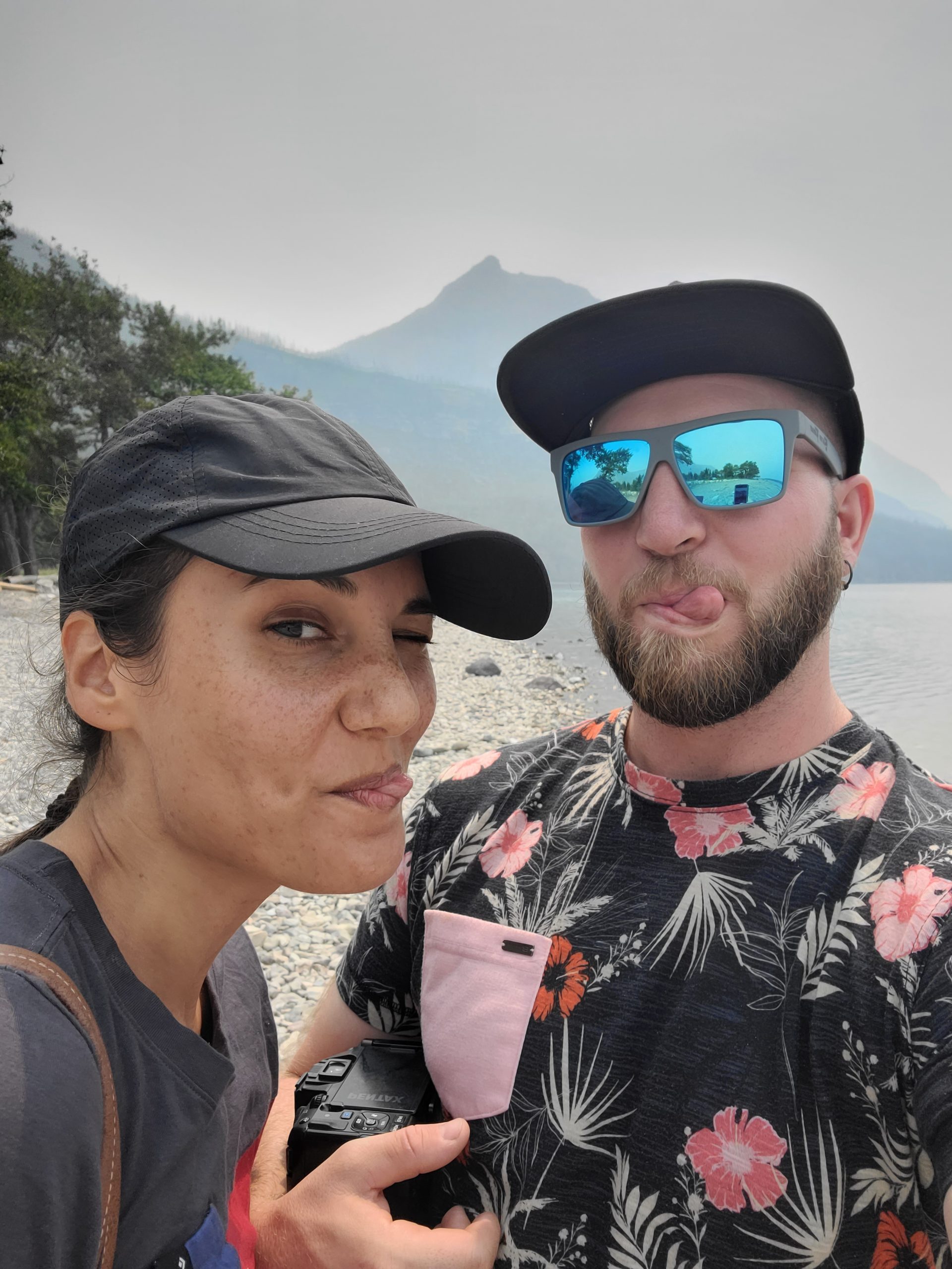
A couple of nerds hanging out at the beach.
Maybe it was the smoke, or maybe it was spending the last two weeks in the saddle cycling, but my pack felt much heavier than it usually did. I eagerly shed the weight at Bertha Bay campsite on our way in to lighten the load as we continued on to the Southern Terminus. The Terminus is stark and plain, but I feel like it suits the GDT; it’s not there to impress you, it simply marks the start (or the end) and it’s up to each individual to give it meaning.

Me at the Southern Terminus.
We left after we were bored of skipping rocks. Dinner called to us and we made better time back to Bertha Bay.
Day 2 – Bertha Bay to Lone Lake
Trail distance: 42 km
You know when two people don’t want to say goodbye so they do whatever they can to push it back? Well, that’s why I ended up having breakfast at Zum’s around 9:30 instead of continuing to hike. I am not a man who readily declines breakfast, especially bacon and eggs before hiking.
I made it back to the trail by 10:50 or so, 3 km in to my 42 km day; it was at that point that I started thinking I might have bitten off more than I could chew. I wish I had checked the elevation profile before planning my mileage for each day; had I done so, I might have reconsidered some of my campsite choices. But reservations have been made, and plans set in place that must be (mostly) followed. So I began the climb to Carthew Pass.
The trail climbs steadily through a burn that would have been hot had it not been overcast that morning. As I neared Alderson Lake, the clouds started to dissipate and I was able to see some of the mountains around me. I was on a mission so I blew past Alderson, but ran into a couple of hikers who we had seen earlier at Bertha Bay; we chatted for a bit, before I took off to the pass, eagerly anticipating a lunch. The trail passes by several scenic lakes that would likely have been nice for a dip if I wasn’t in such a rush to get to the top. I passed by with just enough time to look back and admire them.

Looking back towards the lakes I passed from near the top of Carthew Pass.
Once I reached the pass, I was ready for a real break. Lunch was a tuna wrap with some Ruffles All Dressed chips spread on top; the first of many such lunches, yet delicious none the less. I spotted the couple on their way up the pass just as I was finishing my lunch. I was jealous of the Subway sandwiches they had brought with them, but still satisfied with my choice as I was full. After another gab sesh, it was time to take off. The descent to Cameron Lake was fairly uneventful. More burns to pass through, limited water sources, and not a soul in sight until I reached the bottom. From there, it was a simple road walk (again, through a burn) to the start of the next (big) ascent to Lineham Ridge.

The road walk to the next trailhead.
At the trailhead I decided to make some dinner to fuel myself up for the climb (and because it was getting late); there was also a convenient stream which made making my dinner that much easier. By 7 pm I was done. My feet were hurting a bit, but I felt ready to tackle the climb.
By the time I reached Rowe Meadow, I was exhausted, yet the trail continued onwards and upwards. After a brief break to fill up my water (and battle some mosquitoes), I started the long slog to the ridge. When I reached the ridge, I was presented with even more ridge to traverse up; it was the gift that kept on giving. I eventually reached a high point around 9:30 or so and then began a long descent into the valley below. By then, the sky began to darken and still had 9 or so kilometers to go and I was not moving fast.
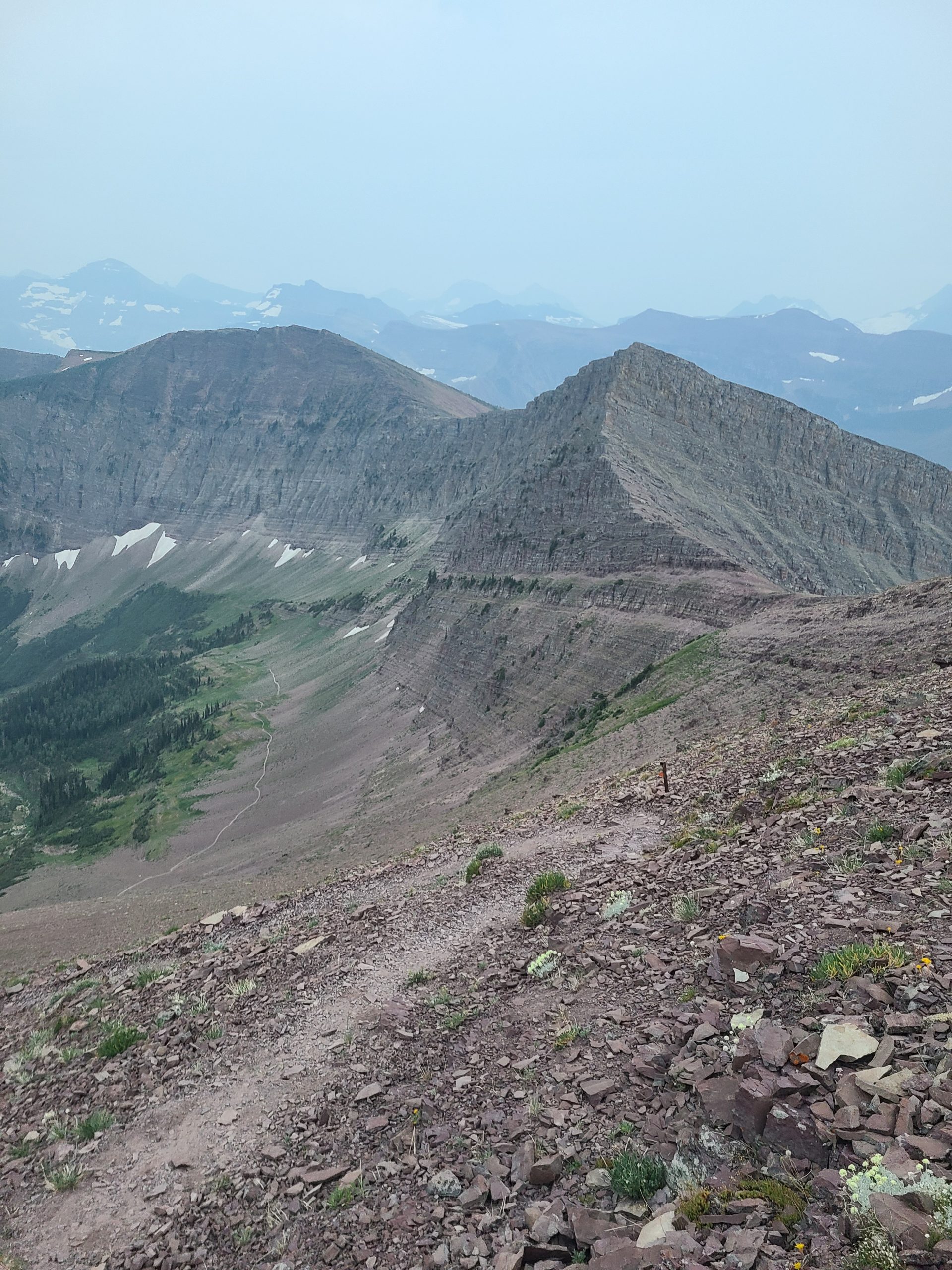
Looking down from Lineham Ridge.
I slogged through the burnt forest, turned on my headlamp and some tunes, and continued on. I reached a point just before the final climb where I needed a break. However, I saw a pair of eyes down by the creek staring up at me. I wondered what it was as it started moving towards me; I hoped that it was a cougar or something worse, but what other kind of animal walks towards a human at night with a headlamp and music on?
Turns out it was a very curious buck. I made more noise, but he continued towards me. I eventually had to toss some rocks before he ran away. Satisfied that he had left, I took my pack off and had a seat. A few minutes later a branch snapped behind me and I turned around to see the buck there again. I told him to leave me alone or I would eat him, but I packed up and left anyways.
I arrived at my campsite around 12:30, long after I thought I would, but happy nonetheless to have made it.
Day 3 – Lone Lake to La Coulotte Ridge
Trail distance: 23.5 km
Today was a brief day. I was exhausted after the previous day’s adventure so I took it much easier. I didn’t set an alarm (something I try to avoid as much as possible while thru-hiking), took my time packing up and having breakfast, and moving at a much slower pace in general. My body hurt. I was sore in places that I hadn’t been sore in for a long while. Most of all, my feet were sore; the trail is much sharper than I was used to and it had especially taken its toll yesterday. However, as the day wound on, I found myself feeling more and more empowered to keep on hiking. My body was recovering with my relaxed pace, and I felt like I could go on and on and on.
However, I found an incredible spot just before the top of La Coulotte Ridge that beckoned me to stop. I hummed and hawed over the spot for almost 10 minutes before finally deciding that I would stay. It was nice and windy, which helped to keep the bugs at bay. It also had a phenomenal view to the east and would make for quite the sunrise. I had a feeling that I could make up some of that distance tomorrow by taking the main trail down to Castle Mountain instead of taking the Barnaby Ridge Alternate as I had initially planned. After some dinner, my body told me to chill and relax, so I climbed into my tent, pulled up the sleeping bag, and watched the sunset through half-closed eyes. It was (already) time for rest.
Day 4 – La Coulotte Ridge to Lynx Creek
Trail distance: 41.5 km

The view from my tent in the morning.
Wow, what a sunrise! My bet had paid off and I was rewarded with some incredible views. I would probably rank this in one of my top 10 places to camp so far. It was worth the dry camp for it. I slowly packed up my things, savouring the early morning light as it washed over me. I had a simple breakfast this morning; a tea with a pop tart because I wanted to save some of the water I had, knowing that my next refill was still quite a ways away. As I was finishing packing up, I had two hikers pass by; I would later pass them on the ascent towards La Coulotte Peak.
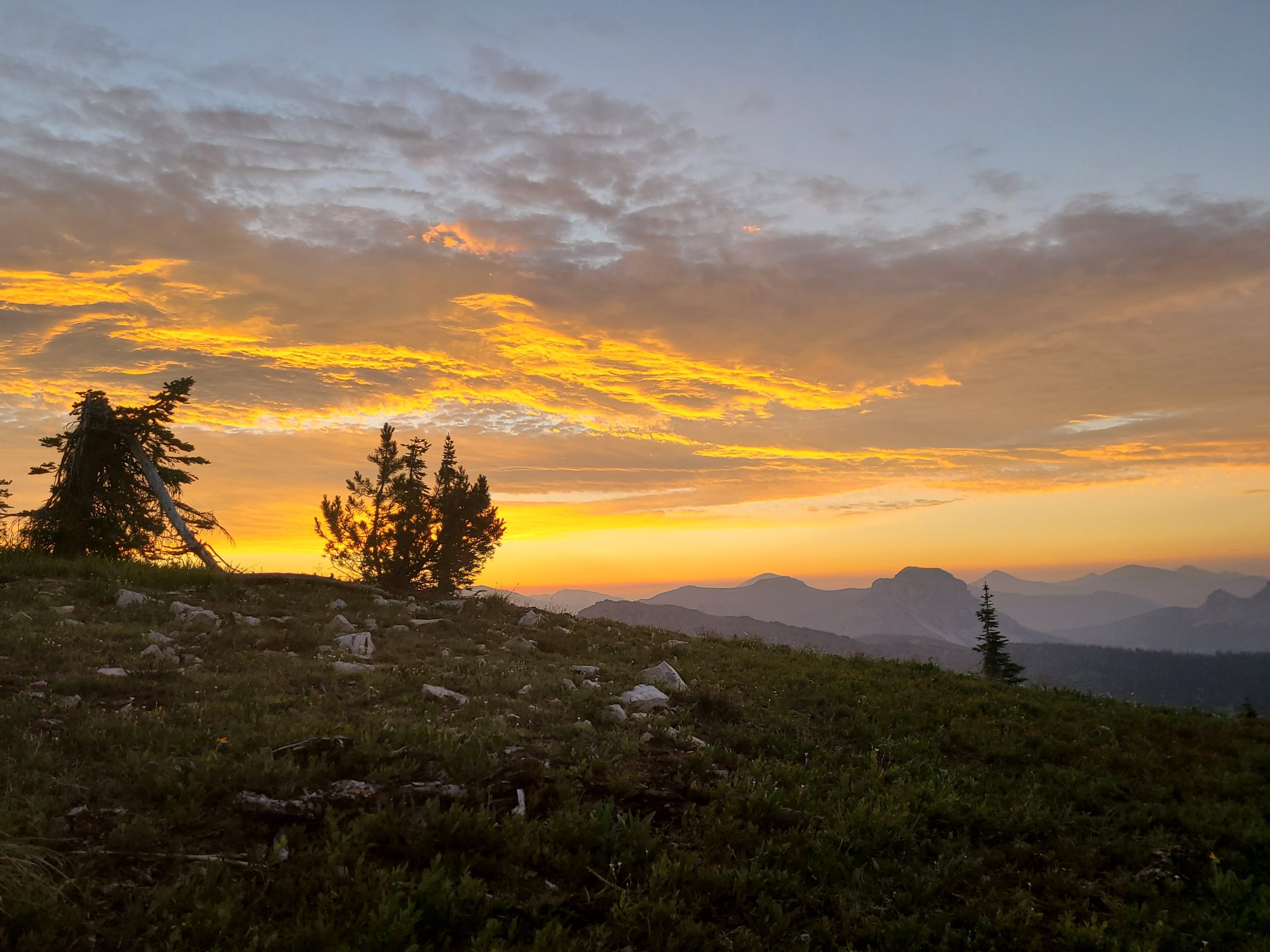
Sunrise from the ridge.
The way to La Coulotte Peak was fairly easy to follow, if steep in a few places. There were parts where it was fun to run down the scree, oddly similar to running downhill through snow.
The section between La Coulotte Peak and the valley bottom was tricky via the main GDT route. There were a couple of parts where you get entirely cliffed out with no warning and no side-trails or markers to help make the way any easier. I opted for a bit of a side scramble to get out of that area, but the only other option was to backtrack up the steep hill I had just descended. Making it to the col between the next ridge didn’t really provide any relief, as it was straight up once again, but this time in the sun and I was running low on water. I slowed my pace down and kept on as best as I could.
At the top of that ridge, I spied some snow which relieved me a bit as I could then drink a little more water and plan to run out by the time I reached the snow. It was still hot work to get there though. One final descent and another ascent to reach the snow and I just ran out of water when I reached the snow; I was pooched, but happy to have some snow to help cool me down.
After filling my bottles with snow, I began the steep descent to the valley bottom via an old atv track.

Looking down towards the ATV track.
It was rocky, and the footing wasn’t always the most optimal, but I made it to the valley bottom just as a storm rolled through. It soaked me and all the plants I had to push through along the slightly overgrown trail. When I reached a creek with no viable log or rocks to hop across, I marched through the creek with barely a moment’s hesitation as I was already soaked because of the bushes and the storm. About 3 km out of Castle Mountain Resort, the sky began to lighten and the rain eased off and I quickly began to dry off. I stopped for some lunch just past the resort so that I could take off some of my wet clothing and allow it to dry in the sun.
Following a good break, it was a decent road walk to the next water source and trailhead towards Lynx Creek. The final push there wasn’t too bad; the ascent was fairly well graded and once I reached the atv track at the top it was pretty cruisy all the way to Lynx Creek.
Day 5 – Lynx Creek to Coleman
Trail distance: 33 km
My mantra for today was “Dinner is at 6 pm.” It’s funny how the promise of good food motivates you to get up earlier than you often intend to, and to hike faster than you have been. I seemed to soar up the climb towards Willoughby Ridge; maybe it was the fact that it was a clear day, or maybe it was the promise of food. Either way, my feet felt lighter and I wasn’t as tired; the last day before town is always the nicest as your backpack is always the lightest. When I reached the road on the other side of the ridge, I didn’t really feel like taking a break, but did so anyways.

Willoughby Ridge and a blue sky.
The last stretch to Coleman blurred by. It wasn’t nearly as scenic, so I wasn’t stopping as often to take pictures. I reached Coleman well before 6 and Dan greeted me warmly and then showed me around. I cannot say enough good things about Alannah and Dan who run A Safe Haven B & B; if you’re planning on hiking the GDT, you should stay with them. They’re incredibly friendly and welcoming, will feed you more food than you can probably handle, and you can do laundry there. They’ll even help with resupply runs. Stay with them; you won’t regret it.
 ">
">


Comments 5
Wow, Bertha to Lone Lake in one day. Took me 3 days this summer to hike that. Carthew Summit and Lineham Ridge we’re hard days as it is, never mind both climbs in one day lol. Good on you
Haha, thanks. I definitely wish that I had looked at the elevation profile before choosing to do that. I was pretty dang tired by the time I reached camp. My body felt those climbs on the following days, too.