 ">
">
The Foothills Trail: A 77-Mile Taste of the Southern Appalachians
The idea for the Foothills Trail, a National Recreation Trail located in far western South Carolina, began in the 1960s as an effort to preserve and protect the beauty of the Appalachian Foothills. A trail corridor linking Table Rock State Park in the north/east to Oconee State Park to the south/west, was completed in 1981.
The trail features sturdy bridges crossing over numerous rivers, beautiful waterfalls, a jaunt around a corner of Lake Jocassee, and, on the eastern half of the trail, steep climbs of up to 2,000 feet that rival anything on the southern Appalachian Trail.

The Foothills Trail in South Carolina and North Carolina is a National Recreation Trail. Photo: Clay Bonnyman Evans
Water is plentiful, camping is allowed on all but a few miles of the trail, resupply is fairly easy, and the trail is well marked. Although mostly well-built and -maintained, as of October 2018 there were quite a few blowdowns, including a couple that force hikers into significant bushwhacking and route-finding back to the trail.
Once as high as the Rocky Mountains or Alps, some 480 million years of erosion have substantially decreased the elevation of the Appalachian Mountains (which extend, believe it or not, into Scotland). But the eastern/northern third of the trail, in particular, is as steep and rugged as the southern Appalachian Trail.
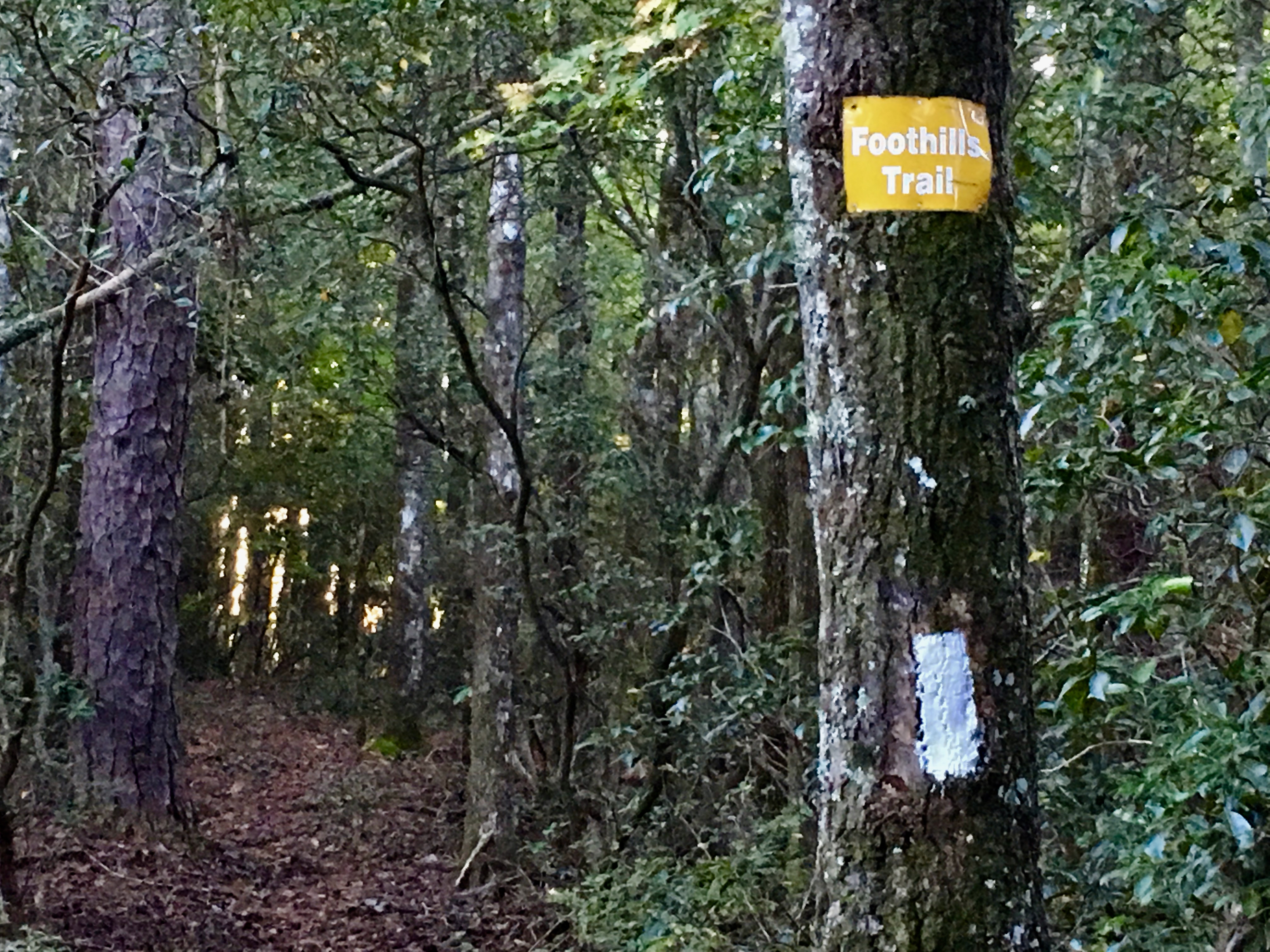
The Foothills Trail is well-marked with white blazes. Photo: Clay Bonnyman Evans
Overall, south/westbound hikers (SWOBOs?) gain approximately 10,900 feet of elevation, while north/eastbounders (NEBOs?) gain about 10,000 feet (the Foothills Trail Conservancy does not offer exact totals; approximations are based on an overall elevation profile).
The tread on most of the trail is largely free of rocks and roots, except for a few limited areas, making for pleasant hiking. Well-built bridges cross major waterways and the FTC has laid hundreds of wood-block steps into the steepest sections of trail.
Foothills Trail At-a-Glance
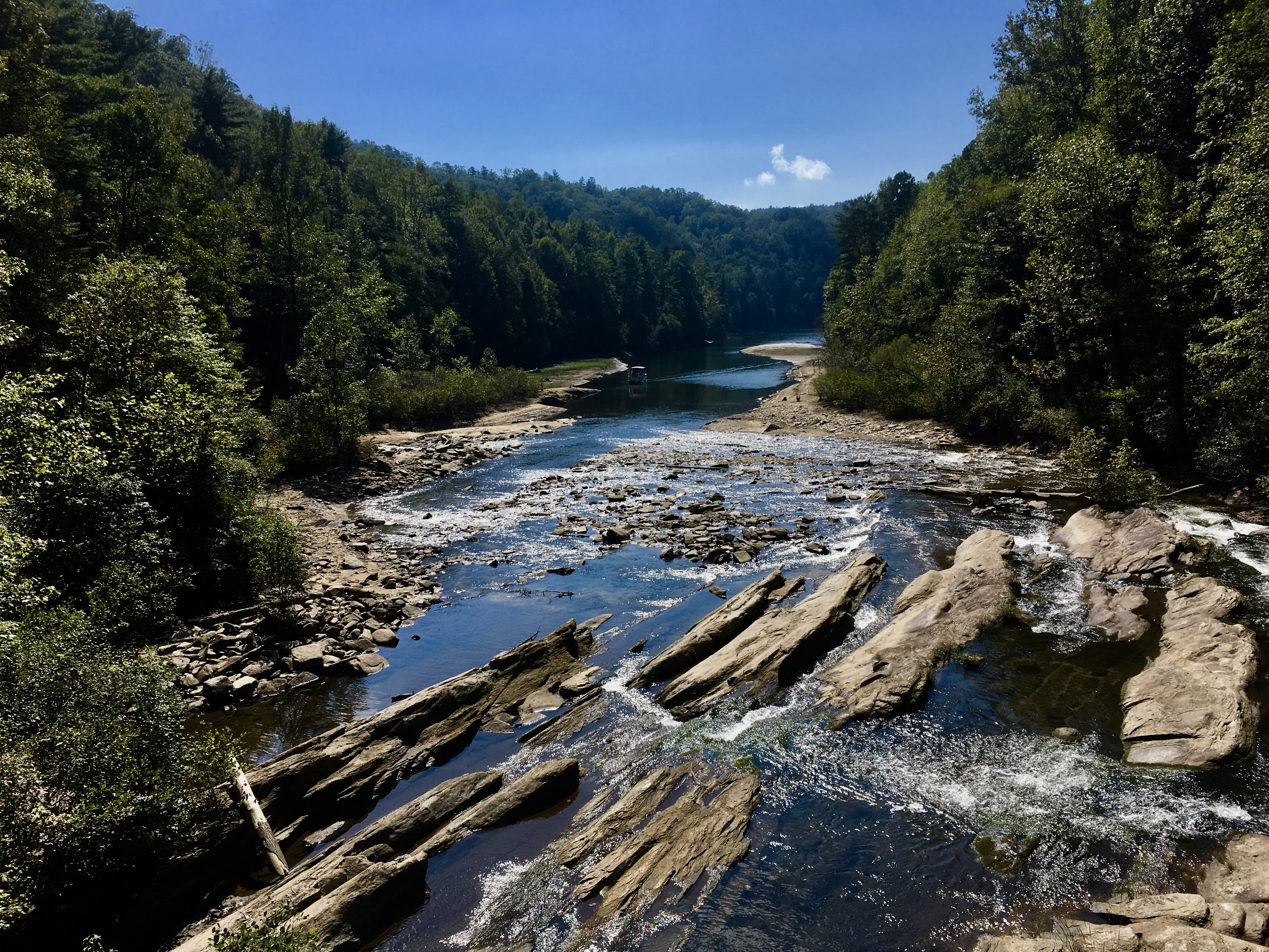
The Toxaway River flows into Lake Jocassee along the Foothills Trail. Photo: Clay Bonnyman Evans
Length: 76.2 miles (the Foothills Trail Conservancy rounds this off to 77 miles).
Location: The trail runs slightly northeast-southwest in far western South Carolina, with several crossings into North Carolina.
Trail type: Shuttle end-to-end.
Scenery: Mostly forests, dominated by rhododendron, mountain laurel, oak and pine, with occasional panoramic views, rivers, waterfalls, and the summit of South Carolina’s highest peak.
Terrain: Easy to moderate on the western/southern part of the trail, with occasional short, steep climbs. Moderate to strenuous on the eastern/northern portion of the trail. Exposure is minimal, and many climbs feature artificial, wood-block steps.
Navigation: The trail is well-marked with white blazes and easily navigable, though as always, you can get off track if you aren’t paying attention. The Foothills Trail Conservancy store offers a complete guidebook, map, and pocket profile. Scott Lynch’s pocket guide, Hiking South Carolina’s Foothills Trail, is another popular option.
Why Hike the Foothills Trail
The Foothills Trail is a fun, challenging traipse through classic southern Appalachian terrain. The trail epitomizes the green tunnel phenomenon, but that just makes its periodic panoramic views even more rewarding. If you like water, the trail offers constant swimming opportunities, waterfalls, and flowing rivers to lull hikers to sleep.
This is a four-season trail, hikeable even in winter. There is abundant wildlife and hikers have a good chance of seeing deer, snakes, toads, frogs, raccoons, waterfowl, raptors, and more.
This is a worthy trail in its own right, but many hikers use the Foothills Trail as a kind of shakedown, warm-up, or training-wheel expedition for an AT thru-hike. The terrain, tread, and grades—from riverside meandering to lung-busting steep—all reflect the AT in its Georgia, Tennessee, and North Carolina incarnations. The climate is mild due to lower elevations, which usually means oppressive heat and humidity in late spring, summer, and early fall—good training for the AT’s mid-Atlantic in July.
While there are often more people around features such as Whitewater Falls and Lake Jocassee, hikers will find plenty of solitude on most of the trail, including quiet, secluded campsites.
Getting There
There are multiple easy access points to the Foothills Trail. Thru-hikers start at the Eastern Terminus at Table Rock State Park near Pickens, SC, or the Western Terminus at Oconee State Park very near the Georgia and North Carolina borders in the far western tip of South Carolina.
The FTC website lists shuttle services that cater to long-distance hikers. Table Rock State Park is about an hour’s drive from both Asheville, North Carolina and Spartanburg, SC. Oconee State Park is about two hours from both cities. Oconee is about 2.5 hours and Table Rock is about three hours from Atlanta.
There are also ten other easy access points between the two termini for non-thru-hikers.
Which Direction Should You Hike?

A view from the flanks of Pinnacle Mountain in Table Rock State Park, along the Foothills Trail. Photo: Clay Bonnyman Evans photo
Thru-hikers travel both north/eastbound and south/westbound, but there’s no question that those who travel south/westbound have it a bit tougher. As on the AT, south/westbound Foothills Trail hikers walk straight into a buzzsaw, tackling the highest, most challenging terrain immediately and gaining some 3,000 feet in the first 9.8 miles to the summit of Sassafrass Mountain … on day one.
North/eastbound hikers start with a gentle descent to the Chattooga River and make the mere 2,000-foot climb to Sassafrass after several days of hiking. The western half of the trail covers significantly less grueling terrain overall.
Climate and Weather

A rat snake, coiled alongside the Foothills Trail. Photo: Clay Bonnyman Evans
It’s entirely plausible to hike the Foothills Trail in any season, though late-spring to early summer and fall are most popular.
Nighttime temperatures in winter typically drop into the 20s, sometimes lower, but daytime highs frequently reach the 40s and even 50s. In summer and early fall, the heat and humidity can be a killer—hikers who can tolerate walking in gear literally soaked with sweat will avail themselves of frequent opportunities to swim and wash off chafe-inducing salt and grime.
Insects can be troublesome, especially mosquitoes and biting flies in warmer months. And many a Foothills Trail hiker has found herself sprinting away from the occasional swarm of irritable hornets, especially in fall. The incidence of Lyme disease is very low in South and North Carolina (less than .5 confirmed cases per 100,000 residents), but the black-legged (or deer tick) is present, so be diligent about tick checks.

Gear for Hiking the Foothills Trail

Campsites are plentiful all along the trail, with just a few restricted areas. Photo: Clay Bonnyman Evans
With the exception of the winter months, chances are that weather will be warm and often extremely hot and humid. Most of the year, hikers can leave cold-weather gear at home.
There are no shelters along the trail, and rain is frequent, so hikers should have a good shelter such as a tent, tarp, or hammock.
The Foothills Trail, though steep in places, is not especially rugged, so trail runners are more than adequate.
Bears frequent these mountain areas, so it’s important to bring and adequately hang a bear bag, or use an Ursack setup. A bear canister is probably overkill. Don’t forget the insect repellent… you’ll want it.
Camping
Camping is allowed on most of the trail’s 77 miles, with the following exceptions: 1.7 miles along the Whitewater River on Duke Energy property, starting at around mile 30 (northbound); Table Rock State Park, except in designated campsites at park headquarters. No permits are required, but if you camp in either Oconee or Table Rock state parks, there is a fee.
The standard guidebooks for the Foothills Trail provide detailed information about plentiful camping spots, and there are numerous spots to camp along the way that aren’t listed in either book.
Along the sandy banks of the Chattooga River and just above Laurel Fork Falls are two of many excellent camping spots on the trail.
Foothills Trail Highlights
Camping on a sandbar along the Chattooga River is a backpacker favorite. Photo: Clay Bonnyman Evans.
Mileages listed heading north
Chattooga River Valley (miles 10.6-15.5): Many excellent places to swim and camp along the river, which was one of the locations for the movie Deliverance (but don’t worry; there don’t appear to be any crazed hillbillies in the area).
Whitewater Falls (miles 30-31.7): Six different falls that tumble a total of 800 feet, making it the highest waterfall east of the Mississippi River.
Lake Jocassee (mile 48.5): The rocks beneath the bridge over the Toxaway River make an excellent spot for lunch, rest, or drying out your gear.
Laurel Fork Falls (mile 54.3): A scenic cascade with several streamside campsites just one-tenth of a mile to the east.
Sassafrass Mountain (mile 66.4): At 3,553 feet, the highest point in South Carolina, with 360-degree views from the fire tower on top (note: the tower was closed for construction in late 2018).
Bald Knob (mile 72.5): Expansive view of upstate South Carolina from knees of Pinnacle Mountain.
Water Sources

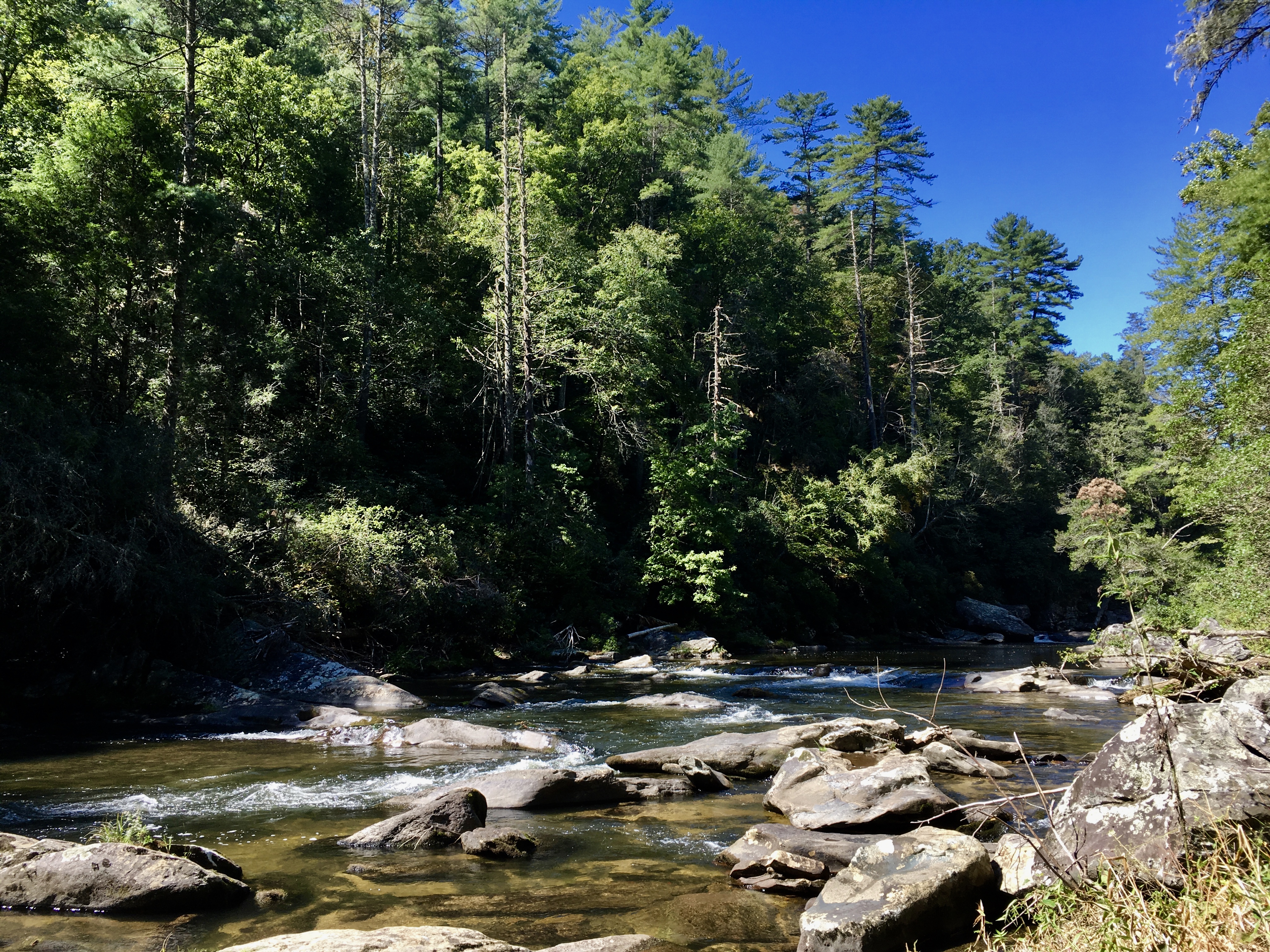
A footbridge across the Horsepasture River on the Foothills Trail. Photo: Clay Bonnyman Evans
In a normal season, there is plentiful water all along the trail. Hikers should fill up before ascending Sassafrass Mountain, particularly northbound; the climb is long and steep, and there are no water sources for 4.5 miles.
Resupply Options
There are numerous road crossings, and hitching into small towns such as Salem, SC, or Sapphire, NC, isn’t too difficult. Some shuttle drivers also will do food drops for a fee.
Closing Thoughts
It’s unfair to reduce the Foothills Trail to a warm-up for the Appalachian Trail. That said, it’s hard to think of a better trail to help newbies figure out if they are going to enjoy the AT.
The southern/western portion of the trail is fairly gentle, but don’t let that fool you. Especially in warm weather, the slog out of Laurel Valley, up Sassafrass, over Pinnacle Mountain, and down, down into Table Rock will tax many a hiker’s glutes and quads. Oh, and there’s the little matter of more than 500 steep steps up Heartbreak Ridge as you leave Lake Jocassee.
Hikers spend a good deal of time in the green tunnel—just like the AT—but ample opportunities to swim, gorgeous waterfalls, and occasional vistas to the south make this a truly enjoyable trail. There are plenty of non-thru options, as well, including the so-called “crown jewel” route, southbound from Laurel Valley to just below Whitewater Falls.
Check out more trails in the Asheville area here.
Related

This website contains affiliate links, which means The Trek may receive a percentage of any product or service you purchase using the links in the articles or advertisements. The buyer pays the same price as they would otherwise, and your purchase helps to support The Trek's ongoing goal to serve you quality backpacking advice and information. Thanks for your support!
To learn more, please visit the About This Site page.

Comments 5
Excellent article. Living in Greenville, the FHT is just a few miles away. It is my favorite trail for many of the reasons you noted. I have thru-hiked it, speed hiked it and section hiked it. Often one can hike for an entire day and not encounter another person. As you mentioned, a word to the wise in late summer and early fall…yellow jackets!
Great review. Will Hike this in a few weeks. Hard to find online is specific locations of good water stops. I suppose the guidebooks will have that and will purchase soon
Thanks again. Enjoy your next adventure.
Hey, Mike N. I’m the author of this piece.
Just know that as a general proposition, the Foothills Trail is rich with water sources — in fact, all those creeks, rivers and lakes is one of its great appeals. I traveled west>east (or, sort of, south>north) and water was never an issue. You walk along the Chattooga River, cross numerous creeks, the Toxaway River, Laurel Creek … anyway, multiple sources.
Check out this page at the Foothills Trail Conservancy. Click on any map and you’ll see what I’m talking about. https://foothillstrail.org/maps-coordinates-2/
Have fun. It’s a gorgeous trail.
~Pony
Fht
Fht youtube