 ">
">
Hiking the Colorado Trail: Segment 18 and 19(ish)
In my continued quest to section hike the Colorado Trail during the next year, I decided to take on a couple of the western sections not currently covered in snow- segments 18 and 19, from CO Highway 114 to the Eddiesville Trailhead in La Garita Wilderness. Although I fell a few miles short of my goal (we’ll get into the why below), battled intense sun exposure, heat, and consequently, minor sun poisoning (#gingerproblems), the experience was still great overall, because any backpacking trip that doesn’t end inside of a grizzly bear is better than sitting at a computer.
Instead of offering a chronological synopsis like the previous update, I will instead present a few highlights and takeaways seeing as these segments were fairly repetitive.
Takeaways
This is basically desert hiking. Although the Colorado Trail Guidebook warns that segments 18 + 19 are largely through cow pastures and thus very exposed, the smallness of my brain didn’t fully anticipate just how much sun this would entail. Had I known, I would’ve worn long sleeves, pants, and a sunhat. Instead, I wore a short sleeve merino blend shirt, running shorts, and a bandana. I reiterate- very small brain. I’m not so inept that I ventured out sans sunscreen, but due to the near 15 hours of continuous sunshine, I had gone through almost my entire 3 oz supply in the first full day (again, #gingerproblems). This largely played into why I had decided to turn back 4 miles short of my target destination, which would’ve translated to an extra three hours of backpacking because…
Out and back hikes are the second worst. Just slightly behind, no hikes. Because segment 18’s trailhead is roughly 3.5 hours from Golden, I was unable to con my girlfriend into making the 7 hour roundtrip drive necessary to make this a one-way trek. My options were to out and back, or rely on a hitch on a low-traffic country road. Wasn’t quite willing to roll the dice, instead opting for retracing my steps. This out-and-back was relatively less-fun due to the extreme sun / heat (mentioned above) and…
Segments 18 and 19 are lackluster by Colorado standards. I’m glad I did what I did, but I will never do these segments in isolation again. More or less, the first 23.5 miles of these two sections- all of segment 18 and segment 19 up to Cochetopa Creek- are redundant and uninspiring by Colorado’s lofty standards (still beautiful, though). I was a little less than thrilled knowing I got to cover this ground twice. In the context of a thru-hike, this area is likely a welcomed relief as the terrain is forgiving, prime conditions for crushing big miles. But for a short section, it felt like something to get through; like I had landed on the lone interlude track on an all-time great album. The terrain was starting to become interesting near the point where I turned around, which had my hiker FOMO flaring real bad, but my bad decisions had already piled high enough. I am looking forward to covering these last four miles at a later time.
Take less, do more. Thanks for the motto, Gossamer Gear. One of the beautiful things about summer backpacking is how little you can get away with carrying (especially ditching the extra clothes + cold-weather bag). I’ve also made a few gear upgrades of late, namely switching to Therm-A-Rest’s NeoAir XLite (highly recommended), which has my base weight lighter than it’s ever been. On my lone full day during this trip, I covered 33 miles. This is further than my longest day on the AT (29 miles), despite being in far worse shape (this is a massive understatement- akin to saying “the special effects in Game of Thrones are better than the original Godzilla”). Granted the terrain was likely easier than any comparable distance on the AT, but given the disparity in fitness levels, I have started to question all laws of science. To clarify, I didn’t comfortably hike 33 miles- I was in a fair amount of pain and pushed myself well into dusk and beyond to avoid having to hike under the afternoon sun on my final day. But 30+ miles were achieved nonetheless.
Highlights
Thru-Hikers! This particular stretch of the Colorado Trail happens to coincide with the Continental Divide Trail, and I was fortunate to cross paths with ten NOBO thru-hikers. I found this to be incredible considering 1) the CDTC only reported 17 completed thru-hikers last year (which has to be low considering our buddy, The Real Hiking Viking, thru-hiked in 2014 and isn’t on the list) and 2) they had already hiked through New Mexico and a decent chunk of Colorado- it’s not like this was near the southern terminus where only a select few have dropped off the trail. I can only recall a handful of the trail names (apologies to the others): it was great meeting Moist, Opa, and Cookie Monster. Keep on truckin’!
Wildlife. Whereas the first two segments presented little in terms of wildlife encounters (i.e. rodents), I happened upon mule deer, monarch butterflies, a porcupine, and cattle (if we’re rounding up to include livestock).


Mountain plains* at dusk. Is baller.
*Is that a thing?


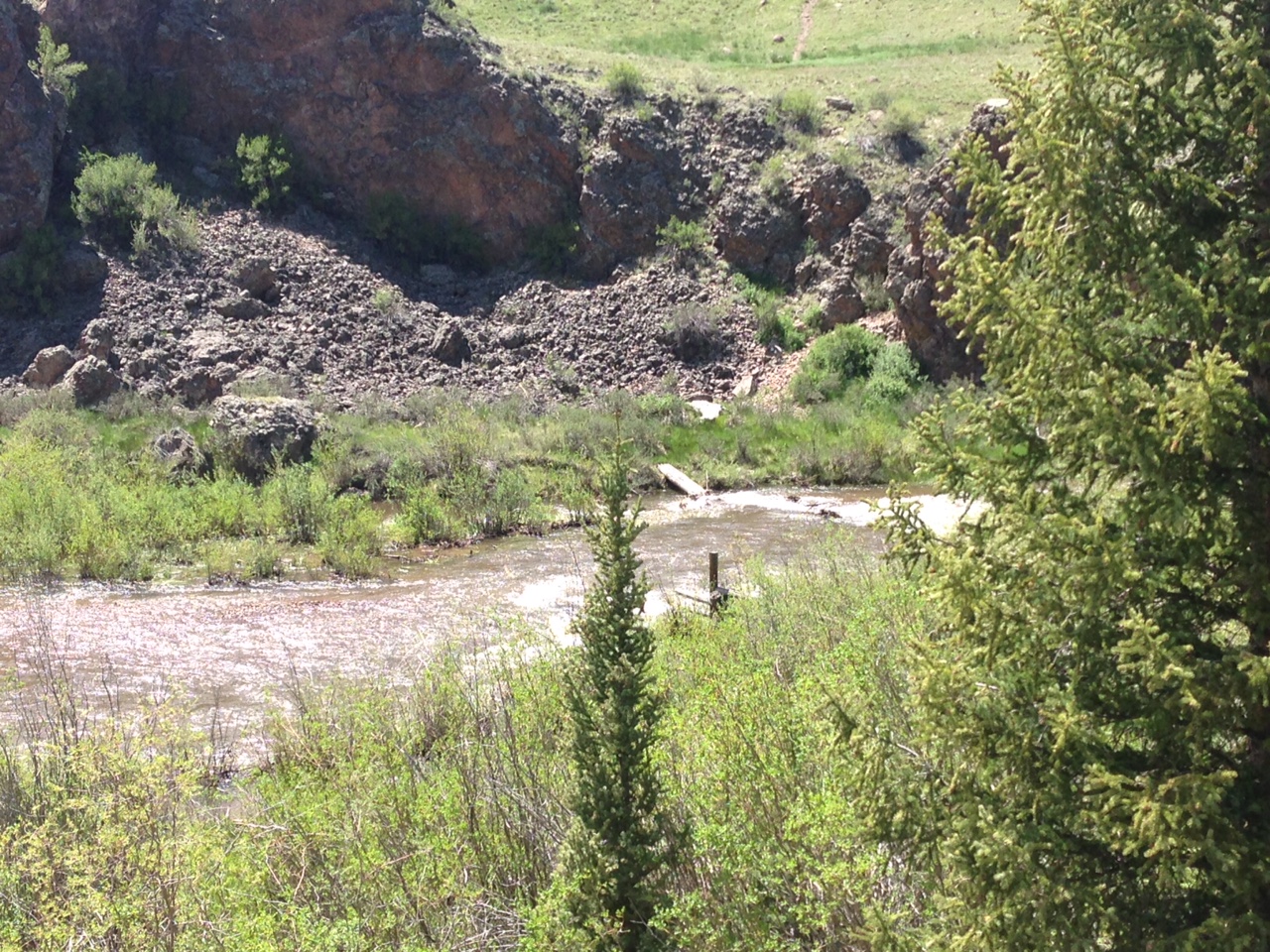
Cochetopa Creek. A couple notes. 1) Because of the ridiculous amount of rain Colorado received in May, water levels are high across the state. The bridge at Cochetopa Creek is washed out and fording seemed dangerous, although each of the thru-hikers I talked obviously had done so. In it’s current condition, I wouldn’t suggest attempting unless you’re experienced with fording in such conditions and/or doing so later than the morning (there’s a nice campsite right before you get to the creek). I had made the decision to turn back at the creek long before arriving, but after getting halfway across the creek and being in near waist deep water, I’m not sure I would’ve been able to push past regardless. 2) Without a doubt, this was the most beautiful stretch of what I saw from the two segments, and what was awaiting me to the southwest looked even better.

More pictures. Here are more pictures.

Stats
Total Distance: 47 miles (23.5 each way)
Elevation gain: 4,564 feet


Taken with my Garmin Fenix 3.

This website contains affiliate links, which means The Trek may receive a percentage of any product or service you purchase using the links in the articles or advertisements. The buyer pays the same price as they would otherwise, and your purchase helps to support The Trek's ongoing goal to serve you quality backpacking advice and information. Thanks for your support!
To learn more, please visit the About This Site page.
