 ">
">
My Over-Researched CT Thru Hike Plan
So What’s the Colorado Trail Again?
The Colorado Trail is 500-ish miles of stunning scenery between Denver and Durango. While that distance may seem (and often is) overwhelming, it’s much simpler to think of the trail as six resupply sections. I’ll lay out the basics of my food carry sections of the trail here, for a more detailed mile-by-mile guide, see this post.
(all mileage is based off of FarOut’s CT Guide)
Resupply Section 1: Mile 0-104.5 (Waterton to Breckenridge)
This is the first section of the trail. I plan to take it slower than the rest of the trail, as I’m acclimating to the altitude. The trail here starts at the Waterton Canyon Trailhead, and over many miles gradually climbs up to Kenosha Pass at around 10,000 feet. After that, it climbs up to the first major pass of the trail, the venerable Georgia Pass (11,875′).

The beautiful Georgia Pass. Photo via Amanda Lauritsen.
The pass is well above treeline, with stunning views. I am worried about the snowpack when I will hike here, as it will likely still be significant (probably miles of postholing). From here, it’s a long descent down to Breckenridge/Frisco. Although this is the longest section, there are plenty of bail out points for an emergency resupply (such as Bailey, Conifer, Jefferson).
Resupply Section 2: Mile 104.5-179 (Breckenridge to Twin Lakes)
From here, the trail winds high up and over the Tenmile Range, one of the steepest and snowiest sections of the trail I’ll face. From there, it continues on the roller coaster of mountain passes until it dips down into the brand spankin’ new Camp Hale-Continental Divide National Monument. After that, it climbs up to Tennessee Pass (where one can hitch to Leadville). From there it continues on through the Holy Cross Wilderness Area, near Turquoise Lake, and enters the Mt. Massive Wilderness. When I’m in this area (conditions permitting), I plan on summitting Mt. Massive and Mt. Elbert back to back as an incredible alternate to the redline.

Mt Elbert is seen reflected in the Twin Lakes. Just to the right, Mt. Massive can also be seen. Photo via Jim Rahtz.
These peaks are the two highest mountains in the state of Colorado (both 14ers), so if the snow conditions aren’t too bad, I plan on “bagging” them. After descending from Mt. Elbert, I’ll drop down into the tiny historic town of Twin Lakes to pick up a resupply package.
Resupply Section 3: Mile 179-253 (Twin Lakes to Salida)
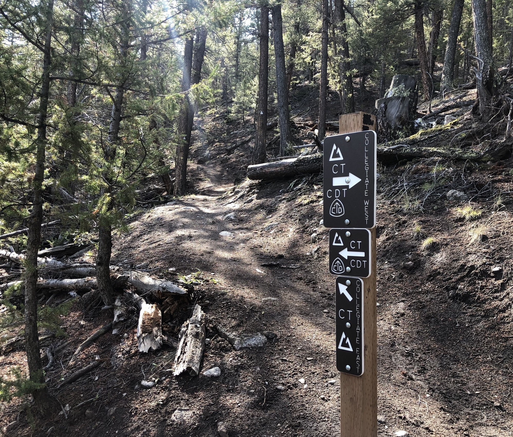
Here we come to a conundrum– the trail splits at Twin Lakes into the Collegiate East (best understood as the “low route”), and the Collegiate West (best understood as the “high route”).
Confused? Everyone else too. Photo via Rachel Pierstorff.
While it seems that the West is almost universally recommended by hikers, I will likely be forced to take the eastern route because of the snow that time of year. Lake Ann Pass on the Collegiate West route frequently remains impassable from the snowpack well into July in a normal year. This being a high snow year with my itinerary bringing me to Lake Ann on July 4, seems increasingly unfeasible to take the loftier route. If I run into plenty of happy, intact NOBO hikers off the western route, then perhaps I’ll reconsider that.
In any case, I’ll continue down through the Collegiate Peaks Wilderness to Monarch Pass, and then wonderful Salida.

I’ll take a zero here! Photo via Kelly Floro.
Hopefully, I’ll be able to take a zero (hiker slang for a full day with no hiking) while I’m in Salida. During that zero, I’ll shop for food, hang out downtown, and maybe soak in the hot springs, before…
Resupply Section 4: Mile 253-363 (Salida to Lake City)
From here, the trail gets a lot less eventful for a little while. You leave the high peaks of the Collegiates behind, and hike through a bunch of cow and sheep pasture. It can be downright mind numbing. However, it doesn’t take tooooooo long before you’re transitioning back into the San Juans. Up and over the high point of the CT, and we’re back in the mountains.
There’s another 14er summit opportunity near the end with San Louis Peak (incidentally the most remote 14er in Colorado), and the scenery starts picking up again around the four passes lovingly referred to as the “four horsemen of the apocalypse.” Sounds lovely, doesn’t it?

Looking towards the San Juans. Photo via Isabella Zenaidah.
After this quick reentry into the high mountains, I’ll drop back down to Spring Creek Pass and Lake City. The town actually has a hiker support center, headed up by the local church. I’m so excited to meet some of the awesome people who run this center and am so thankful they look out for us hikers!
Resupply Section 5: Mile 363-415.6 (Lake City to Molas Lake/Silverton)
This may be a relatively short resupply section, maybe taking only three days, but it is a doozy! It traverses some of the prettiest sections of the San Juans, with several huge climbs and descents. We’re in full mountain territory now!

One of the most incredible views on the trail, looking down into Elk Creek Canyon. Photo via Kelly Floro.
At the end of this segment, I have two options for resupply: mail a box to Molas Lake Campground (on the trail), or hitch a train ride on the Durango-Silverton Narrow Gauge Railroad into Silverton. Which one sounds cooler? I’ll let you be the judge.
Resupply Section 6: Mile 415.6-494 (Molas Lake/Silverton to Durango)
It’s the last segment! And arguably the prettiest too. I mean, who can argue with Taylor Lake?

I mean, truly insane. Photo via The Real Hiking Viking.
Anyway, this section is full sensory overload, but all too quickly I’ll be rolling into Durango. I sure hope I make it this far, because wow does it look beautiful.

Indian Trail Ridge, a place known for terrible weather. Doesn’t look so bad, does it? Photo also via The Real Hiking Viking.
And After That?
Once I complete the trail, I’ll head down to New Mexico for Wilderness Trek with my youth group, a guided trip to summit a mountain there. I’m sure by then, I’ll be so excited to see the people that I love!
Conclusion
I’m so excited to be out on the trail in a couple weeks! While I have a whole plan laid out here to get me from Denver to Durango, I’m not naïve enough to think that I’ll follow it to the T (I mean, I have a whole spreadsheet and everything). However, I’ll use it as a guide to know if I’m ahead or behind on my goals.
Do you have any thoughts or suggestions! Put them down in the comments!
Until next time!

This website contains affiliate links, which means The Trek may receive a percentage of any product or service you purchase using the links in the articles or advertisements. The buyer pays the same price as they would otherwise, and your purchase helps to support The Trek's ongoing goal to serve you quality backpacking advice and information. Thanks for your support!
To learn more, please visit the About This Site page.

Comments 2
Glad to know someone else has a spreadsheet! Fremont SNOTEL is still showing 30in on 6/1 so yeah. I’m really hoping that since I don’t plan on reaching Brecks/Frisco until July 6/7th that I won’t get caught up in all of it. You’ve got a great plan lined up and it sounds like you’ve got a good head on your shoulders. All the best of luck to you!
If you’re expecting postholing and haven’t taken the Know Before You Go: Avalanche Awareness courses, check them out. https://avalanche.state.co.us/education/caic-programs/know-before-you-go-colorado
Happy Trails!
Hi, I think you have a well thought out plan for CT hike. I will give you a couple of heads up to watch for; collegiate east is good if you would like to hike Mt. Yale as well via east ridge which you have to climb up & over anyway. I have climbed 58 (14ers) & some 5-10 times. Next, Jorosa Mesa & Sargent Mesa are also large above treeline pts. Of the trail to watch for lighting. The most scenic part of trail is from San Luis peak on to Durango. Just another 14er to climb since it is right north of pass, and one of lowest of 14, ooo ft. Peaks. The most scenic of all the trail I believe is the San Juan’s, and especially the scene from 12,800 is pass looking west and down the valley to the train to Silverton. I would suggest mailing a resupply to Molass campground which is right on trail and skip the train to Silverton, which I did and I wouldn’t do it again. Finally, Indian Trail Ridge was very impressive the views were extensive and kind of imposing with clouds and rain in the distant west mens. I suggest to get a camp before going up the switchbacks to the ridge which seeks up on rather quickly. Set your alarm for 3:30am and be on trail with head lamp 4:30am. Also there is a stream at that camp very close. To close this conversation , have a wonderful time, & don’t forget to enjoy the scenery! If you have any questions, don’t hesitate to contact me. I finished CT last year, Arizona trail 2021. & I’m heading out to section hike the CDT July 1st. ( just the colorado portion which is 800+ miles) New Mexico to Wyoming.