 ">
">
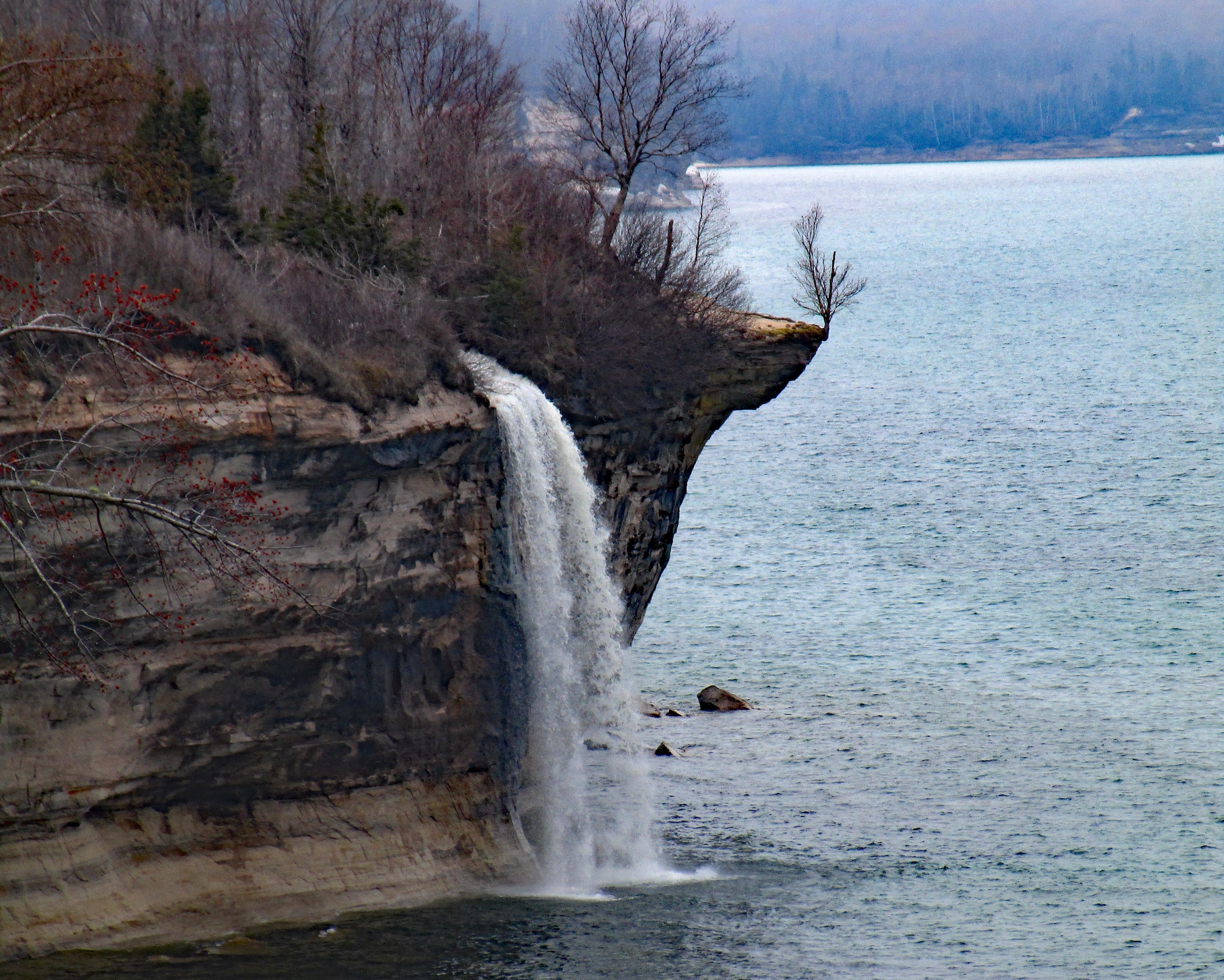
The Lakeshore Trail: Travel the Length of Pictured Rocks National Lakeshore
Pictured Rocks is the setting for the Lakeshore Trail. The path runs the length of the park, approximately 43 miles, and is often within sight of Lake Superior and its spectacular shoreline. Sharing tread with the North Country Trail, the trail is generally well marked and moderate in difficulty as it travels between views. Those with issues with heights should note that the trail, at times, is located right on a cliff’s edge. Camping is by permit only with options located five miles apart or less.
Lakeshore Trail At-a-Glance
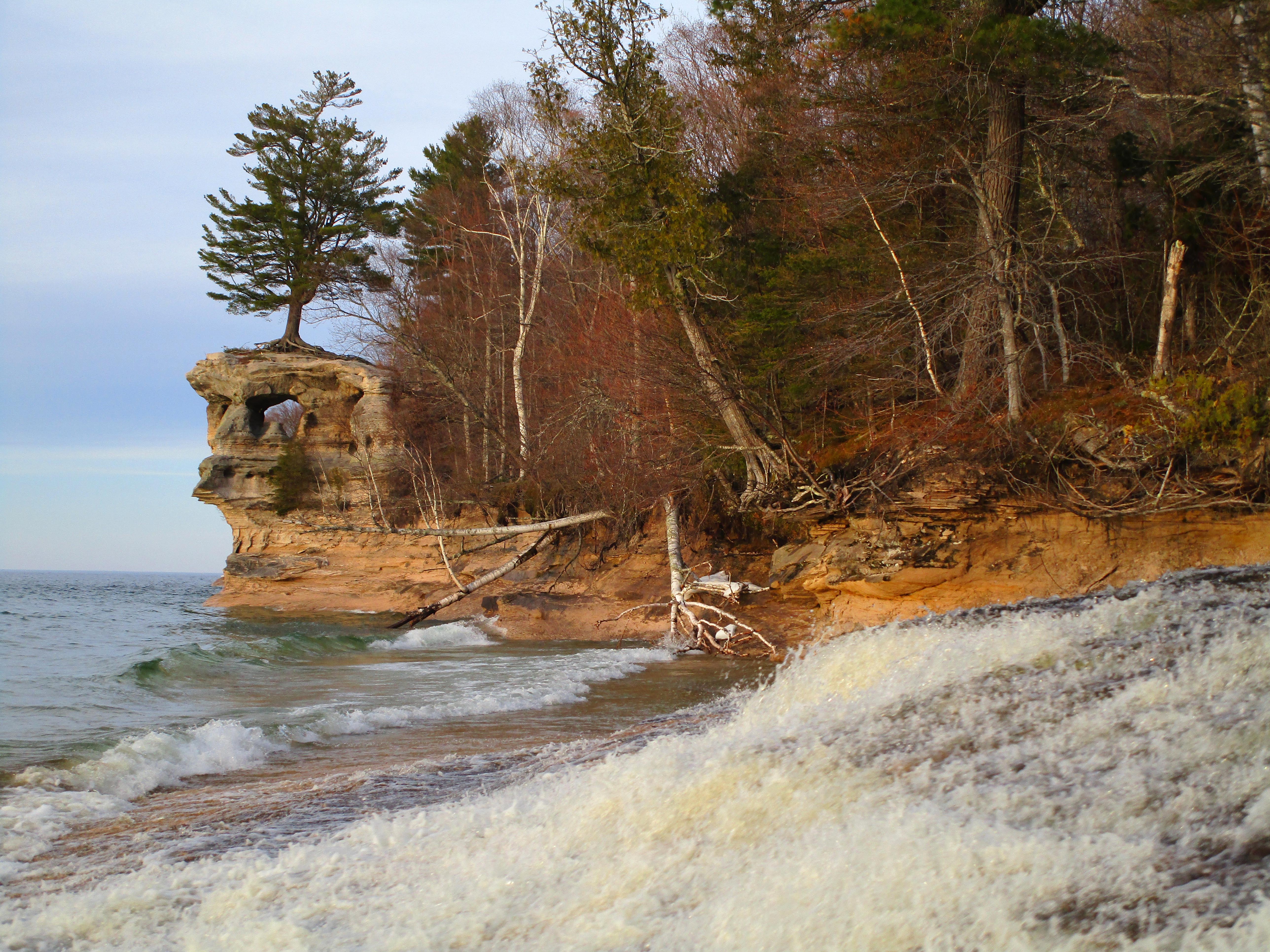
Length: 43 miles
Location: Part of the North Country Trail, the path is located within Pictured Rocks National Lakeshore in Michigan’s Upper Peninsula
Trail Type: Out and back or shuttle
Scenery: Northern forests, massive sand dunes, and the park’s namesake rock cliffs
Terrain
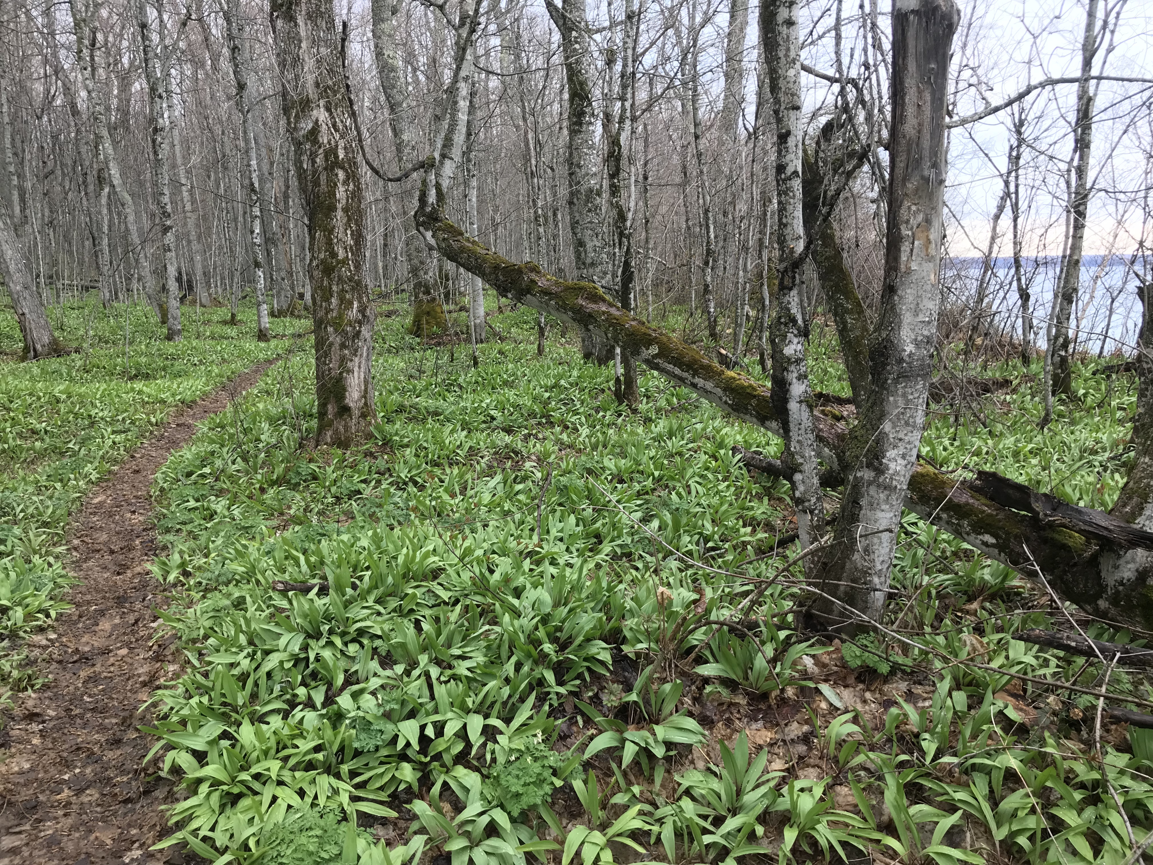
The route generally stays well above the lake, though dropping down to the water’s edge on occasion. Hiking is moderate with a few steep climbs. Some mileage back from the lake travels through poorly drained forests. On a spring trip, waterproof boots turned out to be a good choice.
Getting There
For most, head north through Michigan, over the Mackinac Bridge into the Upper Peninsula. From there, take US 2 west to 77N to 28W to the town of Munising. Those coming from Wisconsin and points west can take 28E through the UP. The Munising Falls Visitor Center is located at 1505 Sand Point Road in Munising.

The easiest way to walk the length of the park is to use the shuttle service provided by Altran, the Alger County Transit system. They are very backpacker friendly and run multiple trips per day between the Munising Falls Visitor Center on the west end of the park to the Grand Sable Visitor Center near the eastern end. The ride is $25 and the driver was happy to take me a mile past the visitor center so I could add Sable Falls to my itinerary. There are other stops available for shorter hikes. Overnight parking is available at either visitor center.
Why Hike This Trail
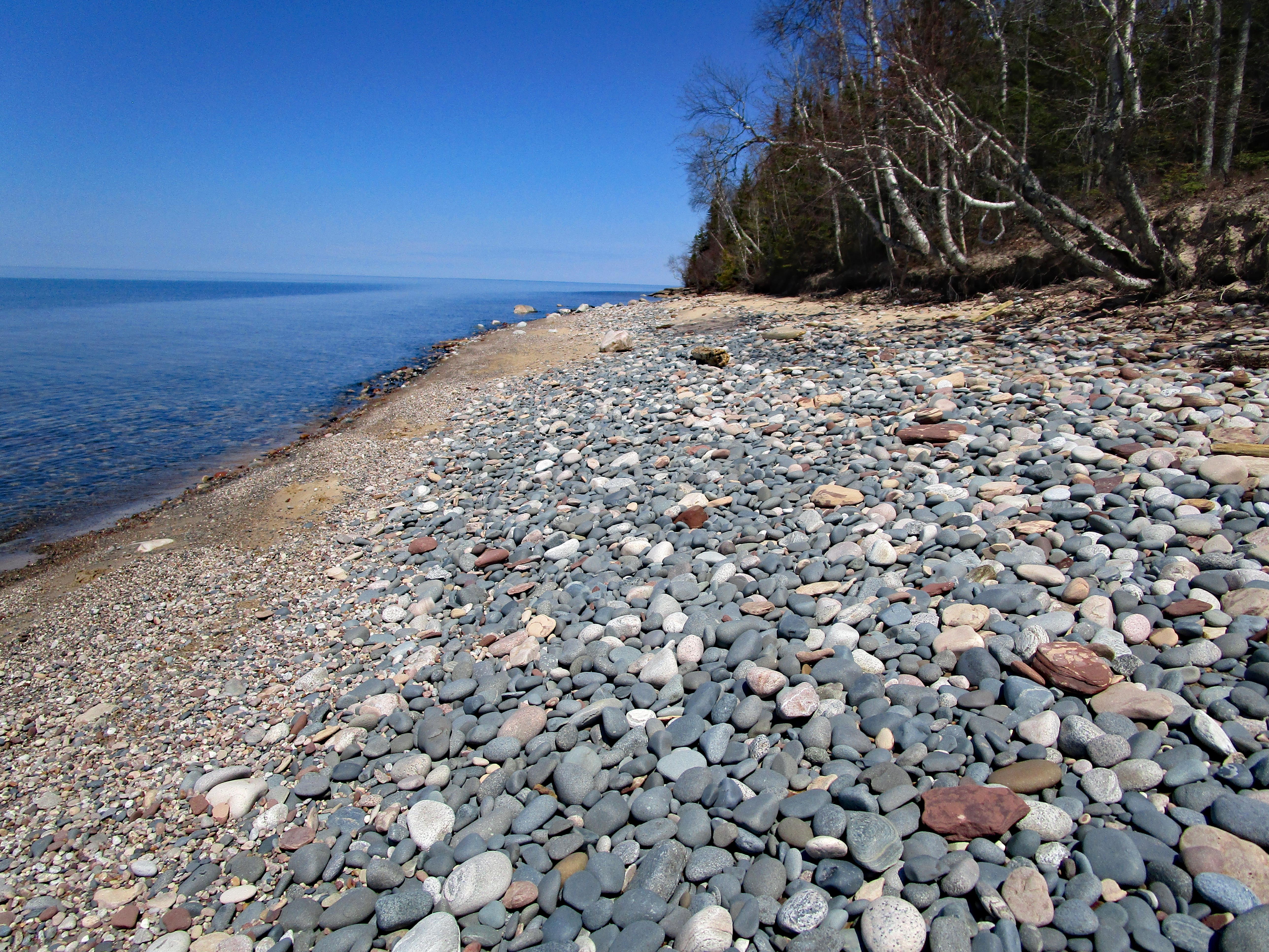
Hiking the Lakeshore Trail is a great way to see the tremendous shoreline of Lake Superior. In just over 40 miles there are countless epic views of rock formations, a lighthouse, options to stroll the lakeshore on both sand and rocky beaches, massive sand dunes and some quality time in the boreal forest.
As with nearly every national park, wildlife take advantage of the protected habitat. Wolf and bear are spotted along the trail along with species specific to the northern forests such as the snowshoe hare. The park is also far enough north that viewing the Northern Lights is a possibility as well.
Climate and Weather

As with any far north location, weather can be an issue. I hiked the trail in mid-May and there was still snow on the trail in spots. Starting much earlier would have been challenging on a heavy snowpack year like 2019. As the snow melts, it also leaves portions of the trail wet and sloppy. At the other end of the season, snow can fall as early as October with an average of 140 inches falling throughout the colder months.
Timing the hike also includes consideration of insects. Both black flies and mosquitoes show up soon after snowmelt and can be an issue through early summer. I was ahead of them for the most part in mid-May in 2019. Later in the summer, stable flies, deer flies, and horseflies all make an unwelcome appearance and can inflict a painful bite. At times, long pants, long sleeves, and even a head net may be required.
July and August tie for the warmest month with the average daily temperature ranging from 56 to 74. Freezing temperatures are possible any month of the year. I brought a 30 degree bag and was glad I did.
By fall, the insect populations have dropped considerably. On the flip side, though, fall is not always the best time to visit weather wise. The area is the second most cloudy region of the US with much of the cloudiness coming in the fall and early winter. At that time of the year, air traveling over the warm lake hits the relatively cooler land and results in significant cloud cover, fog, and rain.
Camping
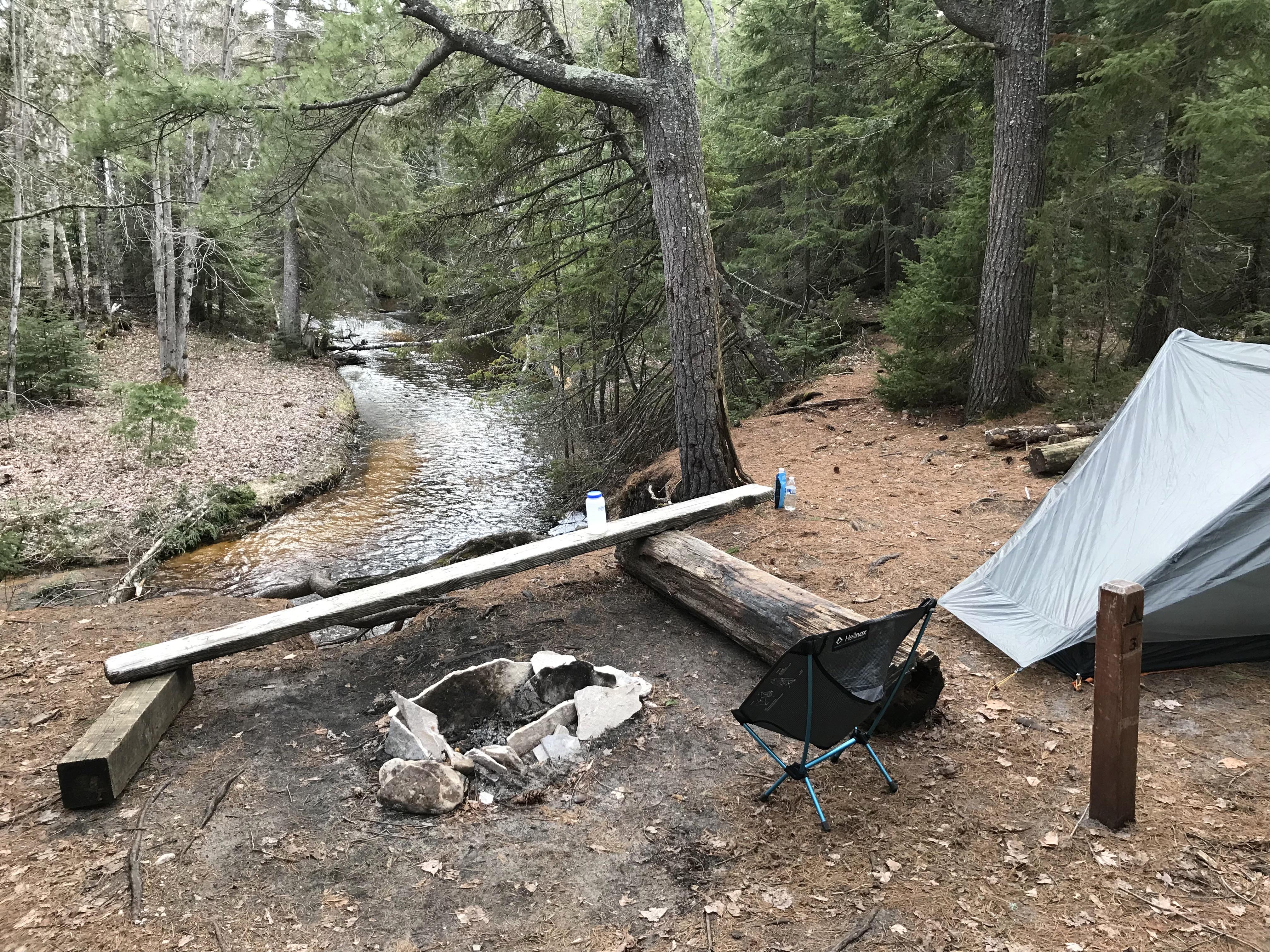
The National Park Service maintains over a dozen backcountry camp areas on or near Lakeshore Trail. Each camp area has spots for three to six small groups. There are also some larger group camping areas. Most, but not all, have access to water, a toilet, and a designated fire ring. The park’s Backcountry Trip Planner lists specifics for each site.
Each site requires an individual permit for the night you plan to stay there. Spots can be reserved in advance through Recreation.gov. There is a $15 reservation fee for the entire itinerary, plus a user fee of $5 per person, per night. If the plan is to visit on a weekend during the summer, it would be a good idea to make those reservations well in advance.
Water Sources
Spray Falls.
Water is generally not an issue. You are walking along the largest freshwater lake in the world, after all. In addition, the trail crosses a number of streams on their way to the lake. The water sources all appear to be relatively clear, but play it safe. Bring a filter and use it.
Closing Thoughts

If you’re looking for a two- to five-day hike with great scenery, simple logistics, an easy-to-follow trail, and camp areas where water and a toilet are accessible, the Lakeshore Trail might be for you. For me, the rock formations are the most impressive I’ve seen this side of the Grand Canyon.
Depending upon when you go, biting insects and/or weather can be an issue, but with proper planning and equipment, the trail is well worth any aggravation encountered.

The National Park Service website has the information needed to start planning a trip to this amazing place. When I had specific questions on snowpack and trail conditions, the folks at the Munising Falls Visitor Center (906-387-3700) were extremely helpful.
Once the hike is over, if you want to see the Pictured Rocks from a different angle, there are both larger tour boats as well as kayak tours locally available. The views from the water are also pretty impressive.

This website contains affiliate links, which means The Trek may receive a percentage of any product or service you purchase using the links in the articles or advertisements. The buyer pays the same price as they would otherwise, and your purchase helps to support The Trek's ongoing goal to serve you quality backpacking advice and information. Thanks for your support!
To learn more, please visit the About This Site page.

Comments 12
a good, tight wrapup of this hike is appreciated. Nice pics.
Tom
Thanks, it’s a great hike.
This is a great article! It’s one of the best segments of the NCT, and a great few days of hiking. Thanks for featuring an “up north” adventure. Triple Crown articles are always interesting, but as a Yooper, I am glad to share this great part of the country with everyone. Really great to see the trail that we call home get sone great attention.
In late August 2015, I hiked this in under four days as one of my shakedown hikes. It was relatively bug free and gorgeous. Wonderful recap. Highly recommend. Hike can be extended by continuing in either direction on the North Country Trail. Plus Grand Marais and Munising are great little Great Lake towns with pubs and restaurants.
Great write up, this is a hidden gem along with most places in the Upper Peninsula of Michigan. Thanks for sharing your hike and photos!
Great article! I just completed the trail in 4 days (5/31-6/3) and it was amazing! Spectacular views, great weather and no bear sightings 🙂 This trip will be hard to top!
Good to hear! Did you have any issues with bugs while you were out?
Awesome article! my husband and I are looking for more adventures in the Midwest! ?
Thanks! I’ve been working on a bucket list goal to hike in all 50 states and now I have my Michigan trail!!!!
Sounds like a great way to see the USA. Good luck!
We love backpacking at PRNL! This is the trail that introduced our daughters to backpacking and we are now planning an AT thru hike as a family. I must ask, what campsite do you have pictured above? We have not stayed at all of them, but we would love to go back and stay at a site with a stream running through! Our daughters would love that. So glad to read your wonderful description of one of our favorite places.
Glad you liked the article. The camp photo is from the camp area at Chapel Beach. The stream reaches the lake just below Chapel Rock (the photo in the article under the heading, “Lakeshore Trail At-a-Glance”)