 ">
">
The Linville Gorge Loop
Linville Gorge Loop ~ 22 Miles
Western North Carolina
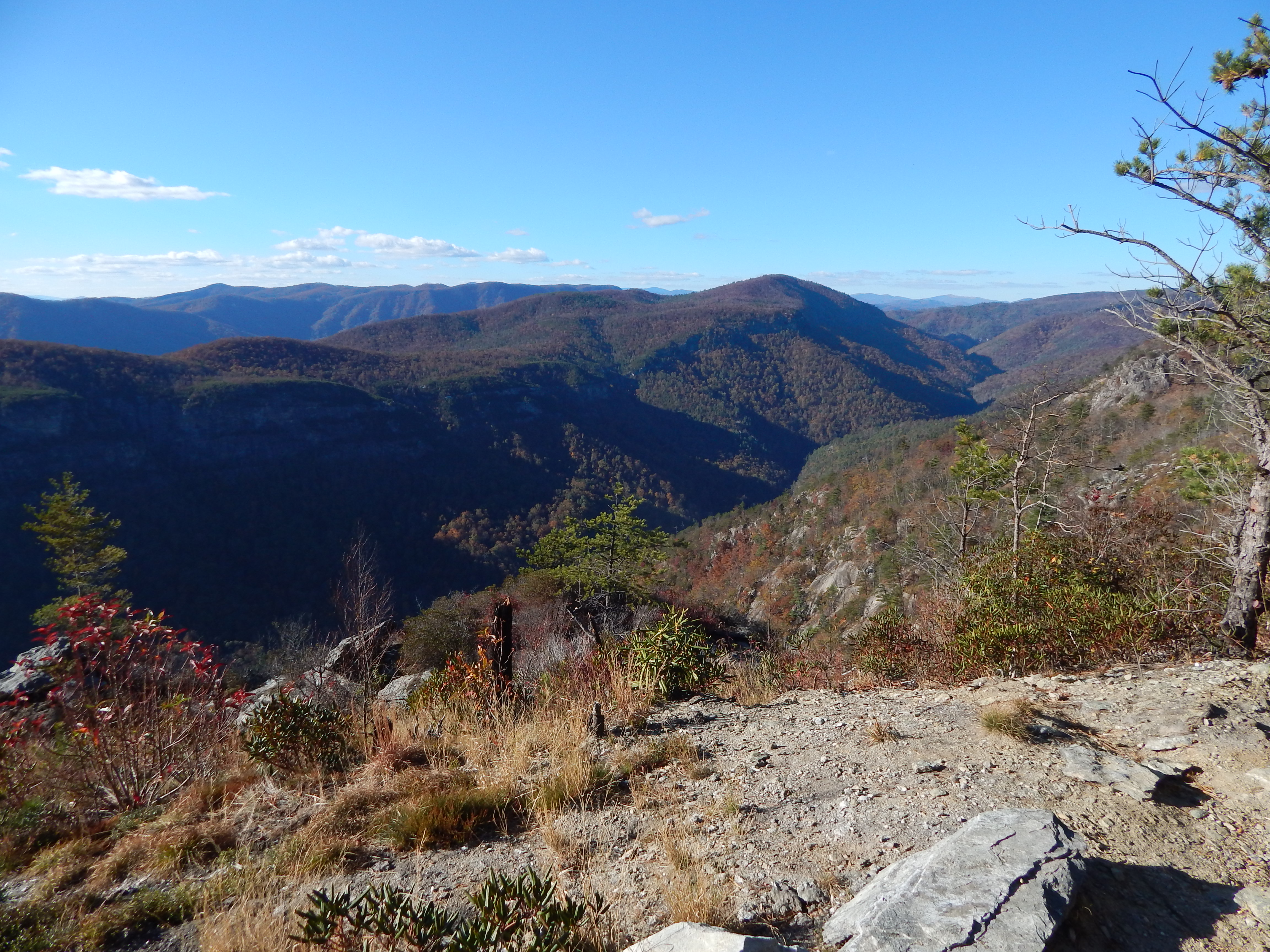
The Linville Gorge Wilderness is located in part of the Pisgah National Forest in Western North Carolina. It is one of only two wilderness gorge areas located in the southern United States and is named in honor of John and William Linville, explorers who were killed by the Shawnee in the gorge in 1766. The Linville river runs through the so called “Grand Canyon of the East” which isn’t lacking in amazing views, strenuous hiking and daring river crossings. When preparing your hike make sure to note that one mile in the Linville Gorge does not equal a mile on other well defined trails and you should expect each mile to last a little longer than planned.
How to Conquer the loop:
First of all you definitely need maps! Download or Print the Linville Gorge Maps Here. The National Geographic Map of the area is not sufficient – Do Not Attempt a loop hike with only that map! Unless you are an expert of the area you will likely get lost without the more detailed version.
There are several ways to complete an adequate loop in the wilderness. The route I ended up completing in a total of 48 hours consisted of the following: Pine Gap Trail ~ Linville Gorge Trail ~Leadmine Extension ~ Mountains to Sea Trail ~ Little Table Rock Trail ~ Spence Ridge Trail ~ Linville Gorge Trail ~ Babel Tower Trail ~ Old 105 Kistler Hwy. There are many other areas to park and complete a loop – take your pick.
Day 1
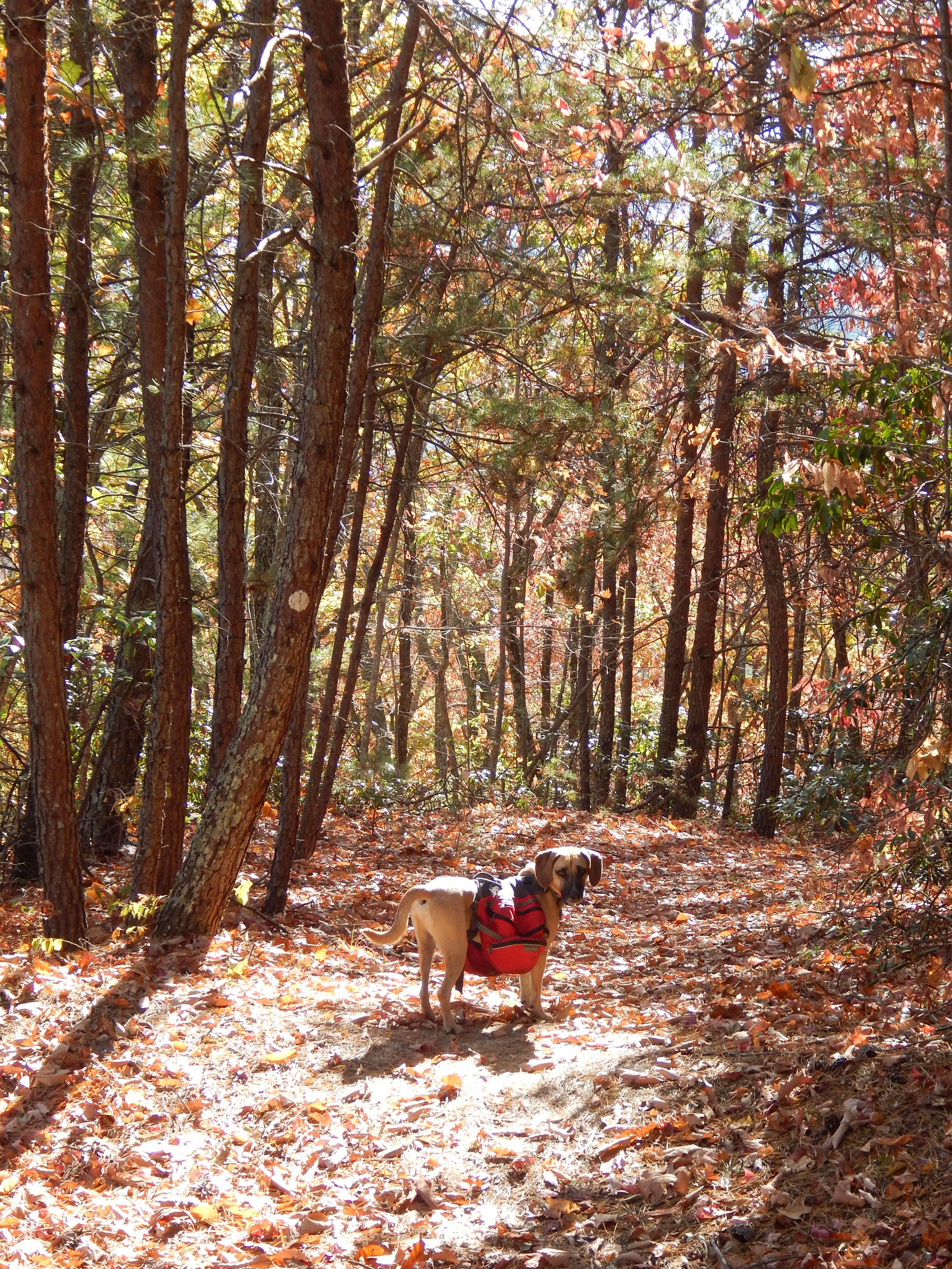
I decided to hike the loop as the first overnight trip for my dog, Tobi. I park my car at the Pine Gap trailhead, load up my gear, get the little one ready and start out just after noon on a thursday. There is only one other car in the parking lot and I feel pretty certain that I won’t run into many people until the weekend.
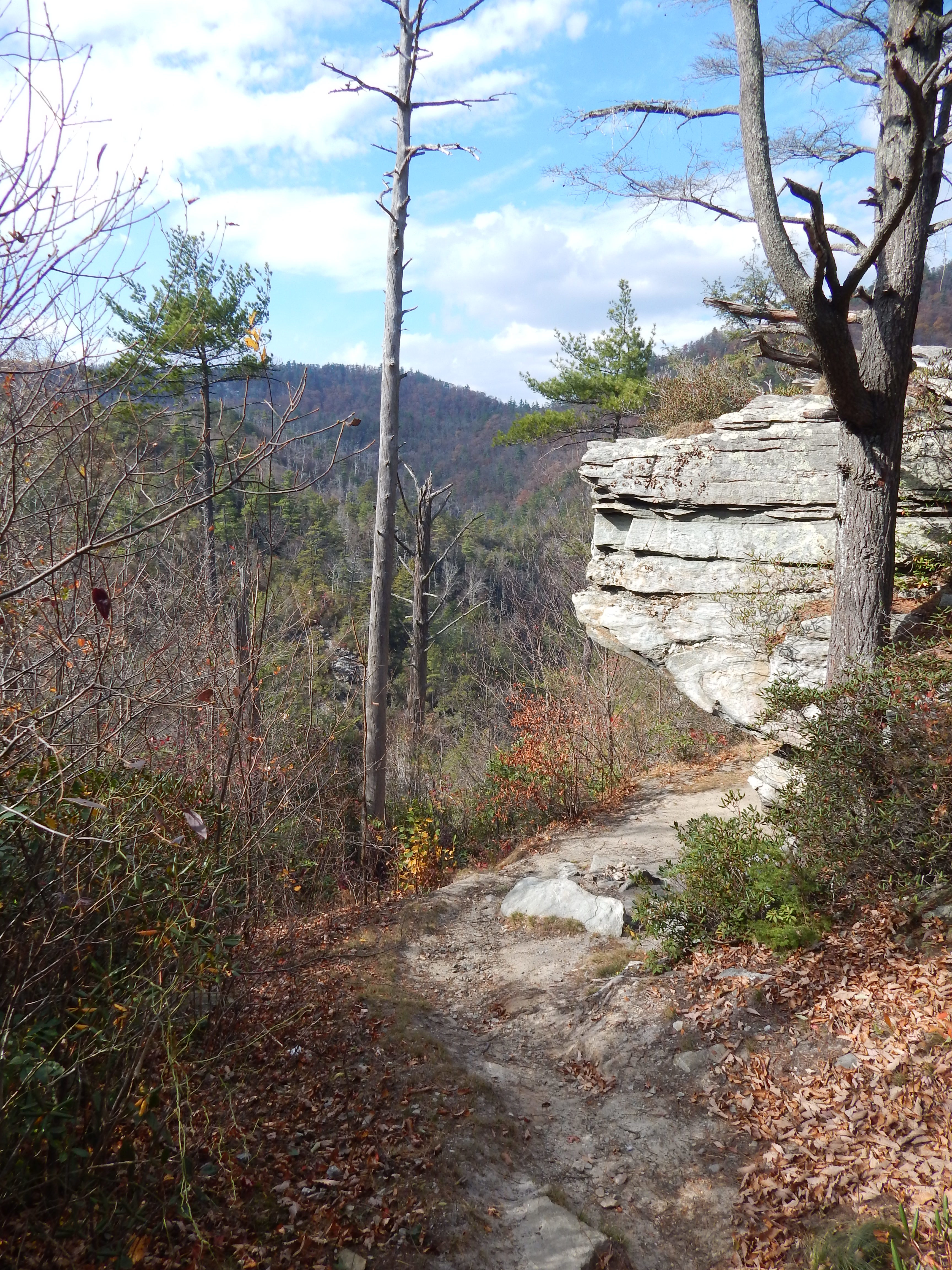
Not having been to the area much before I don’t know what to expect but I’d heard rumour of tough trails. The Pine Gap trail goes down for a few miles into the gorge right from the start – it’s at the time of year where leaves blanket the trail and each step feels a little treacherous especially with the morning dew still glistening on their surfaces. I have Tobi on a leash attached to my pack but I quickly realize with the terrain, slippery ground and hidden rocks we will inevitably injure one or both of us. I weigh my options and decide to break the rules and let him run free. It’s the best decision I make as I slip and slide and cling to low lying limbs occasionally to ease my steps. I hit the Linville Gorge trail and turn right where it eventually hits the river and either meanders along the water or sends you straight back up into woods near neat rock formations for several miles.
The hiking is slower than I imagined but still enjoyable and Tobi bounds ahead of me enjoying himself immensely and constantly making sure I am right behind him. He’s the perfect hiking buddy. It’s past the peak for fall colors here in western North Carolina but it is still beautiful and the slight hint of color throughout the gorge pops and accents the boulders that line the river. The water is low considering the drought which exposes more river rocks than normal.
As I hike along there are multiple times I am convinced I might not be on the gorge trail and look down at my maps that I had printed out and taped together. The trail is narrow and multiple side trails shoot off so it’s easy to get disoriented. If you don’t understand maps and can’t translate contours and elevation into real life in front of you, then you might not want to go into the gorge alone or without someone who has a good sense of what they are doing. I trust that I am still on course and continue on as the sun gets lower and lower in the sky.

At around six I look for the next best camp spot. The trail is now relatively flat and follows the river closely with multiple camp spots and fire pits around. I find a great camp spot right beside the river and off the beaten path for some privacy but notice a bunch of half eaten cans of soup, a tarp and a camp stove off to the side. Nobody is present but it gives me a uneasy feeling so I quickly keep heading down the trail. Just as I’m thinking about taking out my headlamp I find an okay spot and set up camp. I hear a few voices of some other people down the river and Tobi stands guard throughout the night. He thinks any rustling is a predator and occasionally uses his hound howl but otherwise it’s a restful and uneventful evening.
Day 2
The next morning it’s chilly next to the water but I know that it will heat up quick since we are in an unnaturally warm autumn for the mountains. I’m also anticipating the first part of the day knowing that I must find the extension trail that will lead me up to the Mountains to Sea Trail. On the maps it is impossible to tell how many miles I’ve really gone but I think I will be able to put enough miles in to be able to camp up top on the other side of the gorge, catch a sunset and be out the next day by noon. I’m only one evening in but my brain is already focused on what delicious foods I might consume post hike, one of the reasons I love long distance hiking in the first place. Tobi and I follow the trail along the river for a few more miles loving the early morning rays of sunshine that reflect off the peaceful water.

I get to the end of any resemblance of a trail and run into the river with only cliff sides continuing on my side of the water. I check my maps again and know that the turnoff must have been one of the small side trails I passed within the last half mile. I go back about 250 feet and glance up at a small trail blazed with dark blue circles. After venturing up it a minute I get confirmation that I am on the right path – a 1 mile connector trail that hits the Mountains to Sea Trail. I can’t thank the person enough who decided to put this simple sign up to guide lost hikers in the right direction. I wish there were even more signs of confirmation along the gorge trail, but at the same time, feeling lost is part of the adventure.

I’m thankful for this trail that has been created and at the same time it becomes a slip n’ slide considering the ridiculously steep angle of the ascent. Tobi darts ahead and doesn’t seem to be winded in the slightest and turns back to watch me huff and puff up the hillside. The path climbs for awhile before winding around the sides of the hills until it ends right at the Mountains To Sea Trail. I turn left on the MST and enjoy descending on a trail that is wide and well marked. Seeing the white MST circles on the trees is comforting and reassures me I am where I want to be.
The walking is peaceful with the morning sun beginning to warm my body through the trees. I’m starting to realize I might be hungry but I don’t want to eat until I have crossed the river which I know will materialize soon. I’m anticipating an easy crossing at this end where it gets wider but you never know what an experience is really going to be like until you are right in the thick of it. Within an hour I know I am close as the trail hits the bottom near old logging roads and I spot the lazy end of the Linville River. I curse myself for not bringing my crocs but still take off my trail runners, stuff everything in my backpack and decide how I’m going to get Tobi across with me. It seems like the deepest part will be just over my knees but I know that Tobi isn’t going to be happy. I decide to hold my little 37 pound pup in my arms and keep a firm grip on his harness as I step into the chilly water.

I was praying it would be easy but of course Tobi thinks it is actually the worst thing in the world. He begins to whine and fight me to go back to shore only a foot or so into the 100 foot long stretch I have to cross. I move at a snail’s pace to keep my balance and ignore the fact that Tobi’s nails are scratching my thighs so hard that I will have scratch-mark bruises on my legs for weeks afterward. It’s a moment where I just have to grit my teeth and commit to the task at hand knowing that I do not want to turn back. A quarter of the way across I feel both relieved and disappointed that someone isn’t around to either laugh at me or help me.
We eventually reach the other end in exhaustion and Tobi proceeds to be exuberant, thinking that he was the one who really accomplished something. He even walks back out a few feet in the river and proudly stands on a rock forgetting how scared he was just seconds prior. Whatever, he can think he won even though I know he couldn’t have done it without me forcing his little butt across the oh-so-scary river.

As I eat my lunch and calm my nerves from the previous ten minutes of frantic flailing we run into a woman who is finishing up the first Yo-Yo of the Mountains To Sea Trail and her first ever long distance hiking experience. I think to myself that it is an amazing feat to do a thousand mile long trail and turn around and do it again – especially a trail that I think is both terrible and beautiful. Back in May I attempted a self-supported FKT of it but ended my hike after conquering a third of it in good time. Don’t get me wrong, the trail is great and the mountains are beautiful but the 600 miles of roadwalk were not my thing. It was also the first time I didn’t feel comfortable in my own skin as a solo woman hiker and the verbal harassment I received on all the roadwalk portions was consistent and pervasive. It’s really more a fault of our society than of the trail itself, but it still sucked.
I watch her cross the river as if she had done it a hundred times and wish her the best on the last length of her journey. I wolf down my lunch of expired granola bars and meat bars leftover from summer mail drops and then start the climb up to the canyon rim. It’s now pretty darn hot with the uncharacteristic 75 degrees of early November making an appearance. The trail travels through a long burn area and I am exposed to the sun and heat and wish I were back in the shade once more. I filled up on water at the river which is essential when hiking the part of the loop that takes you up on the ledges of the canyon. You aren’t going to find any water up here and the only small, tiny spring that is sometimes trickling just a few miles up is completely dry. I’m not surprised considering the drought western North Carolina was in this summer and fall.

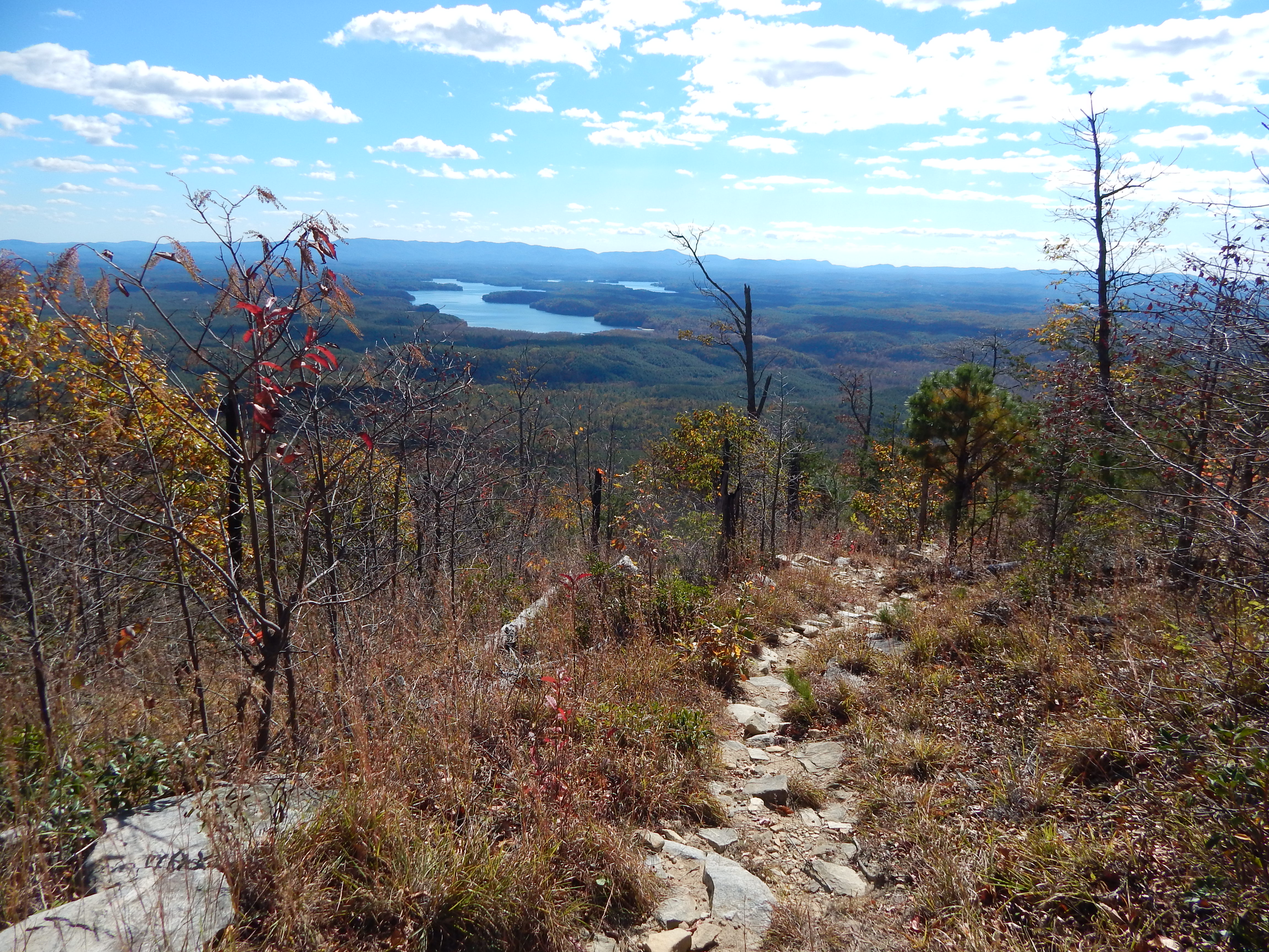
The MST intersects with the Wolf Pit trail shortly and for the first time since hiking out I see other hikers including day hikers up on the ledges enjoying the views. Tobi seems to enjoy the company and gets his ear scratched by everyone as they walk past. When I turn back I am able to see Lake James in the distance shining brightly in the midday sun. It is actually kind of cool to be so exposed up on this ridge and be able to see over the bare treetops.
The afternoon miles are glorious as we crest the ridge and walk near all of the ledges of Shortoff mountain looking down into the gorge. It would be a great place to camp but I am wanting to get past Table Rock and am considering attempting to cross the river again at the Devil’s Hole Trail instead of Spence Ridge so that I can make more miles today and still see the sunset from the top. Eventually the trail goes away from the burn trail and makes a steep descent then ascent up to Table Rock. I see more hikers now and climbers with their gear having fun over the weekend. The whole area of Table Rock up here is gorgeous in the early evening light. We pass through the parking lot and continue on the MST until we turn off onto what we think is the side trail that will get us to Hawksbill Ledge and keep us on top of the gorge.

The trail keeps going down and down, and by the time I’ve realized I’m not on the trail I want to be it’s too late to hike back and I know I will miss the sunset. I’m pissed, I really want to be up on the ledges as dusk creeps in but it just means I will have to come back again. I wish the trails weren’t so terribly marked but I am still thankful the more detailed maps exist – if anyone came out to the gorge with just the National Geographic maps and were attempting to do the loop, they’d be in trouble.
Tobi and I continue our graceful fall down the Spence Ridge trail with our fate of no sunset sealed and camp next to a stream just a quarter of a mile away from the Linville river. I can tell there are quite a few people camped down the way and several times during the night groups of loud teenagers with dim headlamps hike up to who knows where. Tobi barks every time, as he should, but I’m tired and at this point I am eager to hike out the next morning and eat some delicious non-trail food.
Day 3
The morning brings another crossing of the river at a point where there are giant boulders to hop across and rushing water below. There are at least ten people in a group camped right at the edge of the water and they have a campfire built on top of a boulder in the very middle of the river. There is a burn ban for the wilderness but I guess they think the middle of the river doesn’t apply. Two guys happen to be crossing at the exact time as me and thankfully they offer to help me get Tobi across. It’s a feat, again, and this time we actually pick up Tobi by his harness and literally pass him over the water from boulder to boulder. He’s scared and crying but the little man muscles through it. At this point I realize that it was a good thing I missed the side trail last night and didn’t attempt to cross the river upstream where no one would have been able to help me. Tobi and I would have inevitably gotten very wet and I can only imagine how hard it would’ve been to get his body across in one piece. I guess I skipped the sunset and sunrise this time for a reason.
After the river crossing we hop back on the Linville Gorge trail and retrace our steps for a few miles. Since it’s a loop hike I decide to opt for a different route on the way back and take the Babel Tower trail up to the road. It’s super chilly this morning with frost clinging to the ground but my eagerness to get to my warm car quickly burns off the chill. The Babel Tower Trail is nice and well tread and we hit the road close to 11 am. It’s then only about an hour walk back to where my car is parked at the top of the Pine Gap trailhead. A full two days and two nights of some tough backpacking for Tobi dog’s first overnighter. Not bad, not bad at all.

The Linville Gorge Loop is a wonderful loop to do if you have a long weekend. Again, don’t plan on going fast especially if it is raining or it’s at a time when leaves blanket the ground. Even if you decide to not do the loop there are many trails to explore in the wilderness area and you won’t be disappointed when you get up to the ledges even if you miss the sunset. Western North Carolina has so many wonderful hikes to offer the weekend backpacker, so make the most of it and attempt the Linville Gorge Loop sometime!

This website contains affiliate links, which means The Trek may receive a percentage of any product or service you purchase using the links in the articles or advertisements. The buyer pays the same price as they would otherwise, and your purchase helps to support The Trek's ongoing goal to serve you quality backpacking advice and information. Thanks for your support!
To learn more, please visit the About This Site page.

Comments 3
Excellent trip report! Very much enjoyed reading. I did a similar weekend trip in February 2013 with folks from the Outdoor Club at Virginia Tech. We started and ended our hike at the Wolf Pit Road trailhead, but followed most of the route you described. We did use the Nat Geo map, and we did get lost at the southern end of the gorge as we were never able to find the blue blaze connector trail to the MST. Wish I had known about the better maps. Fortunately we were able to find our way out following the river and eventually hitchhiked back to the trailhead. Made for several extra miles and a memorable trip. Your trip report reminded me of how awesome the gorge was and now I want to head back. Thanks again for sharing. Merry Christmas
I live in North Carolina and it’s kind of sad that the mountains-to-sea trail is still not really a trail 40 years in the making. 600 miles of road walking through Greensboro Durham Raleigh areas?…crazy. Why they took it that direction is beyond me. it seems like they should have went South of the triangle and took advantage of the Uwharrie NF and Raven Rock State Park, South Mountains State Park, etc.
I’m a man and I wouldn’t feel comfortable doing much road walking solo….sad that our society is this dangerous.
I had visited the Gorge, briefly, on a couple of occasions some years ago and had been wanting to go back. My dog, Cannon, and hiked it this past July. In trying to decide exactly how to hike it, I read your report, and we did roughly the same loop, starting and ending at Wolf Pit, over two nights. It was hot, challenging, and I had water issues when not alongside the river. I too miscalculated and ended up overnighting at the “saddle camp,” instead of being on the east rim for the sunset. I usually, hike with my teenage daughter, but she was she was at running camp in Brevard, so I hiked solo.
I live in Mobile, AL., but manage to get to N.C. several times a year to hike, mostly fall, winter, and spring. Mountains are all I ever think about anymore, and we spent three weeks in the Rockies this past summer. I will put the Foothills Trail on my “to do” list. If you have not been on it, you should hike the Black Ridge trail which runs north from MT. Mitchell; once you get a few miles from Mitchell, there a few people, especially in winter. I have been wanting to do it again. Regards, JL