 ">
">
Get Lost on the The Lost Coast Trail
The United States is one massive country. If you travel between the four corners of this enormous stretch of land you’ll experience every type of biome you can imagine (almost). Even better is the fact that there are a slew of trails out there beyond the Appalachian Trail that can take you to through these amazing places. I seem to be adding new trails to my Must-Hike List almost daily—a lasting symptom of the Trail Blues I’m sure. Fortunately this month I was able cross one such trail off my list (well half of one) and I’ve only known about its existence since for two months: The Lost Coast Trail. Haven’t heard of it either? Well, with a name like that I can almost guarantee your interest has been peaked. This past weekend I was fortunate enough to hike half of this amazing trail with my fiancé and an old friend from the AT. Sadly time did not permit us a full thru-hike, but you better believe I’ll head back to finish what I started some day.
Since the was an entirely new trail to investigate we had to gather a lot of information together in preparation for the hike. As we researched it seemed like helpful information was scattered and inconsistent across the vast depths of the Internet. Therefore, I’ve decided to try and use this post a one-stop-shop for everything you’ll need to know before setting out on your own adventure on the Lost Coast Trail. So let’s not waste any more time!
Overview: What/Where is the Lost Coast?
The Lost Coast isn’t just the name of a trail. Rather the name defines an almost 80 mile stretch of coastline along northern California in both Humboldt and Mendocino counties. Contained within this area are the King Mountain Range, the King Range National Conservation Area, Sinkyone Wilderness State Park, and a handful of small mountain and coastal towns.
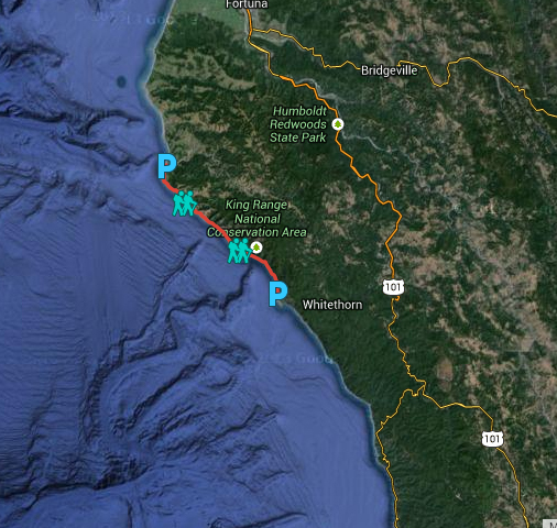
The Lost Coast Trail (My hiking path highlighted in red).
The Lost Coast was given its namesake due to heavy depopulation in the area during the 1930’s, but this area has always been known for its lack of development. The famous California State Route 1 travels almost the entire length of the state’s coastline allowing for one hell of a scenic drive. However, when builders encountered the King Range they determined the land was too complex and unstable for the highway’s construction. They were forced to deviate the highway from it’s coastline route more inland. Route 1 merges with route 101 to pass around the mountain range. As a result the Lost Coast has no major thoroughfare through the area helping to limit both access and development. The nearest major highway is route 101 which sits between 30 – 40 miles from the coast. Access is restricted to those who wish to take the hours to navigate through the King Range’s winding mountain roads. This all culminates into what is one of the largest undeveloped wilderness areas in the state.
In addition the Lost Coast, and by extension the King Mountain Range, is considered one of the most geologically active areas on Earth. A northern portion of the San Andreas fault lies just offshore and touches land at the town of Shelter Cove. The King Range is in fact experiencing “accelerated uplift” as a result of tectonic plate movement. The North American plate is grinding over the Pacific plate causing the terrain to rise. Researchers have estimated that the shoreline has risen approximately 66 feet over the last 6,000 years (that’s actually kind of a big deal)!
The Trail
The Lost Coast Trail is an approximate 52 mile trail that travels along the shoreline of the Lost Coast. The trail can effectively be split into two sections. The northern section of the trail is a 24.4 mile stretch through the King Range National Conservation Area from Mattole Beach to Black Sands Beach. The north seems to be the more frequently traveled of the two sections. The southern section of the trail is a 28 mile stretch running through Sinkyone Wilderness State Park from Hidden Valley to Usal Creek. The north is generally considered the “beach walk” while the south is considered the “ridge walk”. The two sections are divided by a short(ish) road walk outside of Shelter Cove between Black Sands Beach and Hidden Valley. A shuttle can also be used to bridge this gap if necessary. During our own adventure we only had the joy of completing the northern section of the trail.
Best Time to Hike
It is worth noting that the Lost Coast is considered one of the wettest sections of coastline in the state. Average rainfall in the area averages 100 in/yr and during particularly wet years its possible for that number to hit 200 in/yr. That being said the Lost Coast experiences both a wet and a dry season. The wet season falls between the months of October to April. Wet weather can not only cause uncomfortable hiking conditions, but can also make some of the backwoods roads slightly more dangerous to travel. Therefore if you’re looking for a dryer experience hiking somewhere between May and September is your best bet. Hiking earlier in the season you can expect more greenery as well as beautiful fields of blooming flowers. If you wait too long in the season than you’ll have to contend with dropping temperatures. Long story short, pay attention to the forecast for the dates your looking to hike and prepare your gear accordingly.
Map
Go ahead and do yourself a favor by picking up a copy of the Wilderness Press Lost Coast Map. This map will have pretty much all the information you need for both the northern and southern sections of the trail including the locations of various water sources, popular campsites, basic directions to trailheads, and other useful items.
Cell Phone Reception
Virtually non-existent. A phone’s GPS will be handy in finding your way to parking at the trailheads, but don’t expect to get much, if any, cell signal once you enter the the King Range. Cell reception is even limited in certain areas along route 101.
Permits
Permits are required year-round for overnight camping in the King Range Wilderness. It use to be that these permits were self-service at each trail head, but this is no longer the case. Due to the ever increasing popularity of the trail permits must now be reserved in advance on www.recreation.gov. Permits cost $10.00, are good for groups of up to 15 people, must be submitted at least 30 days before your trip.
Last but not least there are seasonal quotas set in place that limit the number of permits available per day. Trailhead entrees for all visitors camping overnight is limited to:
- 60 people per day May 15 through September 15
- 30 people per day September 16 through May 14
Landscape & Scenery

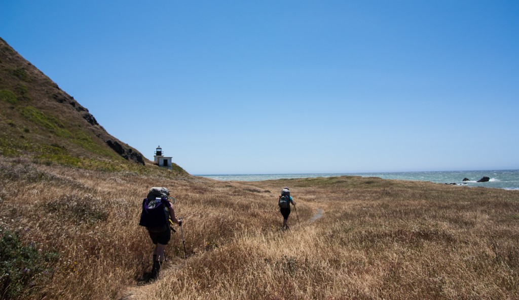
One of the trail’s greatest features is the fact that you will never find yourself bored with your surroundings. If you were to take a week to thru-hike the entirety of the trail you’d find yourself hiking on sandy beaches, rocky shores, grassy fields, through red woods, and old-growth forests. The trail is relatively short, but incredibly diverse for its length. There’s no green tunnel or brown wasteland to fear. Regardless of whether you find yourself hiking northbound or southbound to one side you’ll find the King Range towering above you and with a quick turn of your head be gazing upon the vast blue expanse of the Pacific. As an added bonus the westward facing beaches gift hikers with beautiful ocean sunsets and star-filled nights free of any nearby light pollution.
Elevation
Throughout the trail hikers will be taken back and forth between walking along coastal ridge lines and sandy beach fronts. Generally speaking during the northern section of the trail you will mostly find yourself more or less at sea level. Elevation gains here will be in the tens of feet. As you enter the southern half of the trail the elevation changes will increase back into the several hundreds of feet as the trail rises and falls between ridges and valleys. You are taken to heights where you will find yourself able to gaze down at the coastline below.
Terrain
What the north lacks in elevation it makes up for in tricky terrain. Only about half of this section’s miles are standard dirt trail. When the trail is defined you’re treated to relaxing walks over grassy hills and through amber fields. The remainder of the trail through the King Range National Conservation Area is comprised of either deep, loose, black sand or rocky beaches. Both provide their own challenges. If you’ve ever taken a walk on the beach you should have an idea of how much extra work you have to do walking anywhere on this type of terrain. This feeling is compounded when carrying the weight of a pack on your shoulders. Every step forward makes you feel like you’re sinking half a step back. The best solution is to walk as close to the crashing waves as possible in the hopes that that denser wet sand will provide more stability. The trade off here is that the closer to the water you choose to go, the more of a slant you force yourself to walk as the beach slopes down into the waves. Usually this is the lesser of two evils.
If the beaches are not sandy then they are filled with rocks, stones, and gravel. The stability of the rocks can occasionally be a welcomed relief to the unsteady sand, but the happy feelings do not usually last. It’s like the worst sections of Pennsylvania along the Appalachian Trail if Pennsylvania had epic mountains and an ocean. When it’s put that way it shows how the rocks fields are actually vastly improved in comparison. Yet, transitioning back and forth between super soft and super rigid terrain can get a bit frustrating.

Rocky shores.
While I did not get to hike through the southern section of trail through the Sinkyone Wilderness State Park it sounds as if the stability of the terrain vastly improves. Beach walks become more rare and the trail seems to travel up more along the coastal ridges and through old growth forests. There’s nothing like a bunch of deeply embedded roots to help firm up the ground a little.
Campsites
There are a great number of established camp sites along the trail that should be labeled on any map worth its salt. Some can support fairly large groups while others may only have space for 1 – 2 tents. Most every camp site is built around an established water source with some of the larger camps even set near some enticing swimming holes.

Our Day 1 campsite at Cooskie Creek.
Water
Finding fresh water is a non-issue along this trail. The trail crosses countless creeks, streams, and springs as they empty into the ocean. On our trip we never needed more than 2-liters of water per person at any given time. As always it’s highly recommended to bring along some form of water treatment. And this should go without saying, but I’m going to say it anyway…don’t drink sea water…
Wildlife
The Lost Coast provides incredible opportunities for wildlife sightings. It is a place where the woodland and coastal environments abruptly collide, so you can expect to encounter creatures familiar to both habitats. Sea lions and harbor seals are both a common sight (and sound) along the trail. Numerous rocks protruding just off shore are blanketed with these noisy blobs as the bark and belch each other into the evening.

Apart from the many other coastal creatures you might expect like scurrying crabs and various coastal birds, don’t be surprised if you run into a few reptiles as well. You can spot many small lizards darting every which way along the rocks, but there is also a high probability to run into a northern Pacific rattlesnake. Though we did not have the opportunity of encountering one during our visit, local park signs warn of a high likelihood of encountering one of these snakes somewhere near the trail. The numerous warm rocks, small mammals, and high grasses make it an ideal habitat. Given the more secluded nature of this trail and the fact that it will take you an hour or more on mountain roads to get to a highway, great care should be taken in the event of such an encounter.

We must have missed him by shear moments…
You may also run into a few larger mammals, as well. Black-tailed deer and black bears are not uncommon. It’s weird for me to think of a black bear strolling along a beach, but that’s exactly what they do. Also during one of our relaxing nights a doe practically walked right into our camp without a second thought. Other Lost Coast inhabitants include the Roosevelt Elk and mountain lions (though hopefully you won’t run into one of those.)
A word of caution to the squeamish. Don’t be surprised if you see a fair share of partly devoured sea creatures along the way. Along the beach walks we encountered severed fish heads, large chunks of octopus, and a decapitated seal sporting a hefty shark bite deep through to its organs (simultaneously the coolest and grossest thing I’ve ever seen). The ocean is a terrifying and violent place, so be ready to witness some of its gory aftermath wash up on shore during high tides.
Special Considerations
High Tides

Sample NOAA Tide Table for Shelter Cove
Tide tables are very important for the northern section of the Lost Coast Trail. There are several sections of trail that are impassable at high tide. As a result hikers need make sure they time their hikes so that they can get through these areas while the tide is low. During our trip we didn’t have too much of an issue in this regard. Tides were usually lowering by the time we were starting to hike in the morning and didn’t begin rising again until late afternoon. Regardless it would be wise to carry a reference copy of the tide tables for the dates of your trip either via hard copy or saved on a smart phone. You can access tide tables for Shelter Cove from the National Oceanic and Atmospheric Administration (NOAA) here. It’s generally recommended to not start hiking through one of these tidal areas if it is after 3PM or at tides of 3 feet and up.
Sun Exposure
At least through the northern section of the Lost Coast Trail expect little shade from the sun. The southern section seems to have more frequent tree cover, but in the north trees are few and far between. Early in the morning you can find sanctuary in the shadow of the King Range before the sun crests the ridges, but after that expect to be at the mercy of the sun’s rays. Sun protection, whether it be gobs of sunscreen or long sleeve clothing is highly recommended.
Bear Canisters

A bear canister we rented from the Shelter Cover general store. They required a $70 down payment, and refunded $50 upon the return of the canister. Cash or credit was accepted.
As mentioned early bears are not an uncommon sight in this area. The Bureau of Land Management (BLM) requires that hikers carry bear canisters on the trail. If caught without one you could face a hefty fine or maybe an unpleasant bear encounter. Don’t expect to find a suitable bear bagging tree while at camp along this trail, so really there is little alternative. Don’t own a bear canister? Don’t worry. You can rent bear canisters from certain BLM offices for $5 or from Petrolia and Shelter Cove General Stores at a higher cost. We picked ours up at the Shelter Cove General Store for a $70 downpayment. Upon return of the canister, we received back $50 from our deposit netting a total rental fee of $20. It is important to note that many of the BLM offices are closed on both Saturdays and Sundays, so plan accordingly if you wish to rent a canister.
Strong Winds
Being right on the coastline don’t be surprised if winds are strong and gusty. While hiking these winds provide much needed relief from the heat of the sun, but at camp it caused annoying challenges for our tents and stoves. Most camps have built up somewhat effective wind breaks to utilize, but it’s something to keep in mind. Those who wish to avoid walking against the wind should hike the trail southbound. In this direction, you will find the wind to your back more often than not.
Bring Gaiters

Seriously…bring gaiters.
This would have been a smart thing for us to have considered bringing along BEFORE heading out on the trail, but alas our brains were not thinking clearly. If it hasn’t been made abundantly clear by now you’re going to be walking on sand…like a lot. It’s gonna get in your shoes one way or another. So do you self a favor and bring along you favorite set of gaiters to help slow down the process.
Ticks
Just a friendly reminder that ticks are indeed everywhere—even at the beach. During our trip our group collectively found three ticks scurrying on our bodies looking for a meal, two of which chose me. Ticks don’t just hang out in tall grass. They love to chill on fallen wood and rocks just as much. Keep your eyes open and be sure to do those fun tick checks every night!
Directions & Parking
The drives to reach the trail heads are long, but often scenic. The easiest way to gain access to the mountain roads is to approach from Route 101. Should you wish to take a more scenic route the Avenue of the Giants parallels route 101 for quite a ways. So if you’d prefer to take a drive through some beautiful redwood forests this is definitely the way to go. Below I’ve provided Google Map directions to a few of the trailheads. All directions approach from route 101.
Mattole Beach – Northern Terminus
3750 Lighthouse RdPetrolia, CA 95558
The drive to the Mattole Beach trail head is mostly paved up until you’re about to arrive at the beach. This drive is particularly enjoyable as it will take you directly through part of Humbolt Redwoods State Park. The gravel parking lot is large enough to hold 10 – 20 vehicles. Two bathrooms are also present at the trailhead (no plumbing).
Black Sands Beach – North-Central Trail Access
947 Beach RdWhitethorn, CA 95589
Here you’ll find a fully paved parking lot overlooking Black Sands Beach just north of Shelter Cove. This is the ideal southern exit for those looking to just hike the northern portion of the Lost Coast Trail through the King Range National Conservation Area. Bathrooms with running water are present at this parking lot. Roads to this parking lot should all be fully paved.
Hidden Valley – Central Access
1-143 Chemise Mountain RdWhitethorn, CA 95589
This is one of your parking options for accessing the southern section of the trail. According to maps and other resources I have researched there is a parking area shortly off of Chemise Mountain Rd. Though, where along the road these parking areas will appear is unclear as I did not visit them personally. Other resources seem to suggest you should find them very shortly after turning onto Chemise. This will get you access to the trail slightly further north than if you were to proceed down to the Needle Rock Visitor Center. I would not expect to find any bathroom facilities at this location.
Needle Rock Visitor Center – South-Central Trail Access
Needle Rock Visitor CenterBriceland Thorn Rd, CA 95589
The Needle Rock Visitor Center is a second option for access to the southern section of the the Lost Coast Trail. Having not visited this location personally I cannot confirm the size of parking accommodations at the visitor center nor whether or not the center has bathroom facilities. I think it is safe to say there will be a fair amount of unpaved roads the closer you get to the visitor center.
Usal Beach – Southern Terminus
Usal RdWhitethorn, CA 95589
Usal Beach is the southern terminus of the Lost Coast Trail. The trail will empty hikers out into the Usual Campground. The campground offers many spaces for car campers to utilize so finding an open space to park should not be much of an issue. There is also a gravel lot nearer the beach down an unnamed road just off of Usal Rd. Access to this trailhead is mostly along unpaved roads to the beach, but upon arrival ample parking space should be available. As I have not yet personally traveled to this trailhead I cannot confirm whether there are bathroom facilities nearby, but I would wager it is unlikely.
Shuttling Services
If you only have one car, or only wish to use one car hikers can utilize a local shuttle service to get them to their desired trailheads. They aren’t the cheapest shuttles around, but they’re offering to carry your butts a long way over some potentially unsavory roads. It will certainly save you the time and effort of navigating the backwoods mountain roads yourself and provide you the added security of only having to abandon a single car in a lonesome parking lot. Some shuttle services you can investigate further are linked below.
- Lost Coast Adventure Tours
Contact: Blu Graham
707-986-9895 or 707-502-7514
www.lostcoastadventures.com - Mendo Insider Tours
Contact: David Lipkind
707-962-4131
[email protected]
www.mendoinsidertours.com - Bill’s Lost Coast Shuttle
Contact: William G. Abram
707-442-1983
Ready to hike yet?
By now you should have everything you need to start planning an amazing trip along the Lost Coast Trail. If you have any valuable information to contribute or think I’ve missed something crucial in my information please drop a line in the comment section! Just in case you haven’t been enticed enough enjoy a few more tantalizing pictures and a short video from my own trip!


Source
Wilderness Press. “California’s Lost Coast.” Birmingham: Keen Communications, n.d. N. pag. Print.

This website contains affiliate links, which means The Trek may receive a percentage of any product or service you purchase using the links in the articles or advertisements. The buyer pays the same price as they would otherwise, and your purchase helps to support The Trek's ongoing goal to serve you quality backpacking advice and information. Thanks for your support!
To learn more, please visit the About This Site page.

Comments 4
After doing a 7 day thru hike of this trail, I have made some additonal resources available.
Lost Coast Trail google community:
https://plus.google.com/u/0/communities/114693060516611782975
YouTube thru hike series:
https://www.youtube.com/watch?v=rJlJFi5x8yM&list=PL7W5rVlv4cnDuOc_zEl0uIpzYBOCC4I8K
Thanks! This is the best write-up of this trail I’ve found!
Are the trail sections impacted by 3+ high tides marked on the suggested map? I’ve found the tide chart for this upcoming weekend, and it’ll be 3+ until 2:30pm Saturday and 3pm on Sunday. I’m planning on picking up the map tomorrow. I’m concerned we’ll have trouble making much progress given the shorter days, if we can’t hike for much of the day. Planning two days, north to south. North section only.