 ">
">
Lost Creek Wilderness Loop Trail: 37-Miles of Secluded Colorado Backpacking
Five years of experience as a backpacker and I’m still learning. One of last year’s biggest takeaways was that out-and-back hikes are kind of a bummer. Retracing your steps somehow makes time slow down, distances double, and all hills slope steeply upward.
That’s why this year I’ve made an effort to hike mostly loop trails when staging a second car isn’t feasible.
First up on the list was the Lost Creek Wilderness Loop, a trail discovered through Paul Magnanti’s site.
It did not disappoint.
Quick Facts
Dogs are allowed. Must be leashed.
Permits are no charge and self-served at the trailhead.
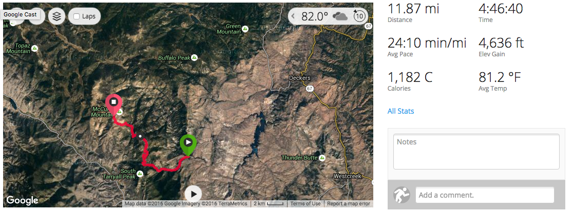
Distance according to my Garmin Fenix 3 was approximately 37 miles (although there’s room for error there, more on that below).
Expected time will be between 2 and 4 days. I hit the trail at 10am on Tuesday and was in my car around noon on Wednesday. I met a couple who were hiking this loop in four days, and they seemed happy with their decision. Pack weight, fitness, and desired downtime will determine where you fall on this spectrum.
The NatGeo Map for this trek can be found here.
Parking / Location / Directions
Despite the last 10+ miles being a dirt road, the Goose Creek Trailhead (the suggested starting point) is accessible by 2wd vehicles (my Civic handled it without issue).
Google Maps suggests that it takes about 2h 40m from Denver, but I found the trip to be faster than the predicted time.
The last ~7 miles of this drive stirred up hype juices like Don King operating a Vitamix.

The Hike
This ~37-mile loop trail* takes you through Colorado’s Lost Creek Wilderness, a gorgeous, 187 sq. mile wilderness area in central Colorado within Pike National Forest. I’ve hiked through various portions of LCW a handful of times, and encounters with fellow hikers and/or bikers are rare. I crossed paths with roughly a dozen people during this loop (a little over 24-hours).
* Other sources have claimed that this loop trail is ~35 miles. My Garmin Fenix 3 would leave me to believe that it was slightly more, but it’s hard to say for certain because it died two hours before I finished.
Segment 1
Segment 2

Segment 3 (watch died about ~2 hours prior to finishing)

If I was slightly less stupid, I could figure out how to get all the GPS data to merge together.
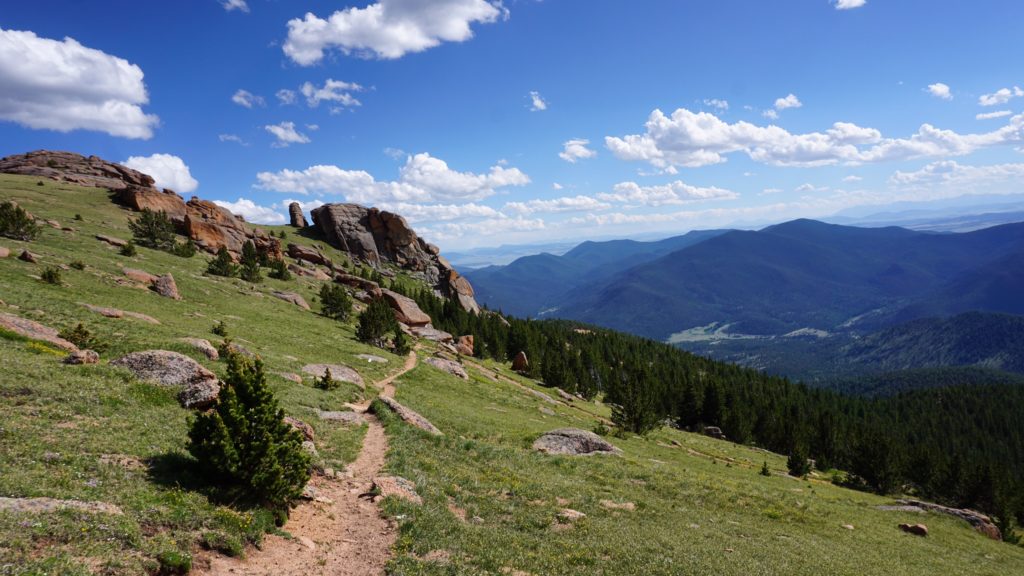
The headliner of this trail is without question the stretch between McCurdy Park and Bison Pass (i.e. the southern half of the Brookside-McCurdy Trail), as demonstrated by the disproportionate number of photos from this stretch (found below). The entire loop is full of charm, featuring a stark contrast in ecosystems, but I had trouble finding photo-worthy moments after passing through this stretch. It’s a bit like trying to enjoy a pear after a bowl of ice cream. Pears are good, but ice cream is meant to be the closer. For this reason, I’d probably hike this loop counter-clockwise if I were to redo it.
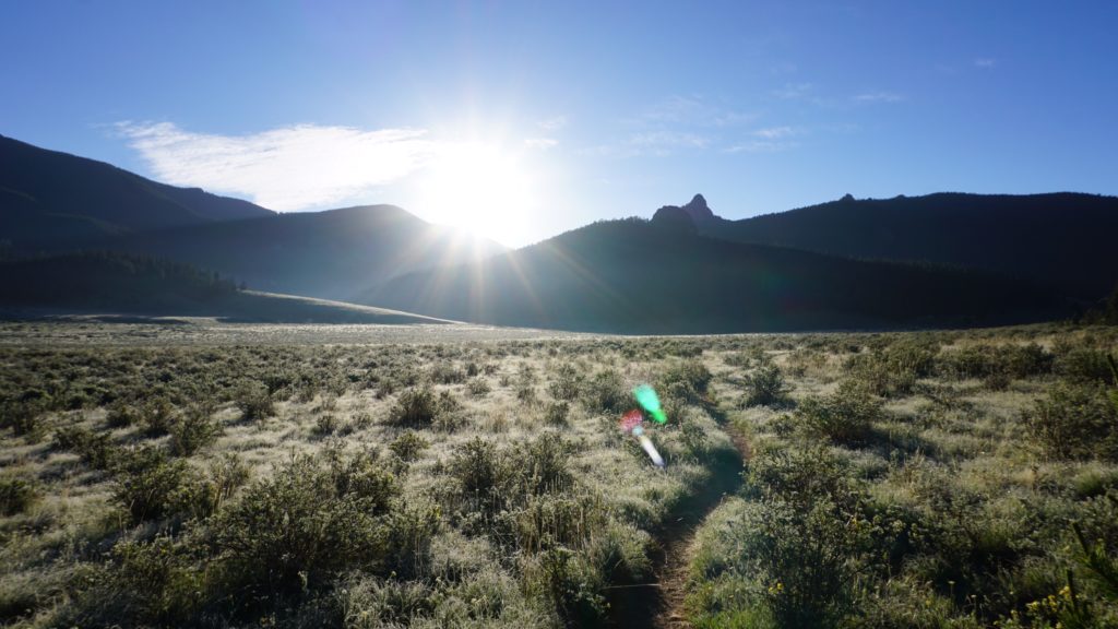
As previously mentioned, this loop begins at the Goose Greek Trailhead. I hiked clockwise, which starts you hiking west on Hankins Pass Trail, the southern most trail in LCW. Once you reach the junction with the Lake Park Trail, head north, and then north again on the Brookside-McCurdy Trail. At the Brookside-McCurdy Trail / McCurdy Park Trail split, continue on the Brookside-McCurdy Trail to the northwest. You’ll remain on this trail for quite some time (~10.5 miles), until heading east on Wigwam Trail (no relation to the socks), and then finally south onto Goose Creek Trail back to your vehicle and, if you planned properly, an ice cold beer chilling in the cooler.

Click to enlarge.
Temperature
I hiked this trail in early July. The temperature ranged between the high 70s and 35-degrees over night (I slept without my rain fly to enjoy the galactic show).
Elevation
The elevation (according to the Fenix 3) ranges between 9,100 and 11,850 feet. I’m not quite sure what the total elevation gain was, since my GPS system pooped the bed prematurely (I should’ve brought a portable battery), but at the point that it died (~2 hours prior to finishing), it was just shy of 6,500 ft. If I were a betting man, I’d venture to guess the total gain was closer to 7,000 ft.
Bugs
Mosquitoes were present, primarily in the wetter sections of this trail, but nothing outrageous. I used a natural bug repellant which did the trick.
Photos
A picture is worth one thousand words, so I’ll spare you the descriptions, and instead let the fancy camera do the talking.
All photos taken with a Sony a6000 or iPhone 6s plus.
Trailhead

Hankins Pass Trail (~4.5 miles)


Lake Park Trail (~4.5 miles)


Brookside-McCurdy Trail (~10.5 miles)


Wigwam Trail (~8.25 miles)


Home for the night

Goose Creek Trail (~9.25 miles- I think)


This website contains affiliate links, which means The Trek may receive a percentage of any product or service you purchase using the links in the articles or advertisements. The buyer pays the same price as they would otherwise, and your purchase helps to support The Trek's ongoing goal to serve you quality backpacking advice and information. Thanks for your support!
To learn more, please visit the About This Site page.

Comments 19
Excuse my ignorance, but how does the elevation range between 9100 and 11,850, but then you say that you can 7000 ft? Wouldn’t 11,850 – 9,100 = 2,750? Or does 9,100 to 11,850 just means those are the ranges of each of the peaks that you travel???
“The elevation (according to the Fenix 3) ranges between 9,100 and 11,850 feet. I’m not quite sure what the total elevation gain was, since my GPS system pooped the bed prematurely (I should’ve brought a portable battery), but at the point that it died (~2 hours prior to finishing), it was just shy of 6,500 ft. If I were a betting man, I’d venture to guess the total gain was closer to 7,000 ft.”
Hey David-
Yup- your premonition is correct. The total elevation gain accounts for all the little ups an downs along the way. The range is just the relative high and low points on the trail.
This report has helped me a ton! Thank you. However, how are we looking on water?
Try and plan getting your water from the creek crossings and not from the “parks” shown on the maps. These are mostly snowmelt marshes and water is not always on the surface. At Lake Park there was surface water but it was red colored and arsenic.
I’ll second this. I attempted this in early September 2018, and the “lakes” or bodies of water on the official Nat Geo Map, simply weren’t present @10.5 miles counterclockwise. I had to get my water from a tiny stream and it took *forever*.
Thanks for sharing your experience. I’m currently planning out my second LCW backpacking trip. I rarely backpack the same place twice so that tells you how much I enjoyed my first visit. As you said the McCurdy Park trail offers the best scenery. Next time continue North on the McCurdy Park trail into Refrigerator Gulch instead of circumventing it on the Brookside-McCurdy trail. This will shorten the loop by probably 10 miles but you’ll see the most iconic part of LCW. Allow yourself time to explore and enjoy!
Just did a portion of this loop. Started at Goose Creek and worked our way up Hankins Pass. Some of my observations:
1. Water is hard to find at higher elevations. You don’t have snow pack feeding the higher elevations.
2. Some of the trails are extremely steep. This is wilderness, not a national park with logical switch backs.
3. We ran into several groups that quickly scaled back their orginal plan of doing the larger loop in four days. Most opted for the smaller loop after the first day of hiking.
Are there any stops or camping areas that allow small fires (we are going early spring and hoping to warm up)? Or is it posted through the whole trail that fires are not permitted?
Created the map of the 35 or 37 mile loop described above, you can download the gpx and kml data from that page. Doing this loop this weekend! Very excited to check it out.
https://www.gaiagps.com/public/HIo3VdobwjjgEbKVzurjYCI6
Gaia GPS and CalTOPO are your friends for getting this map printed and usable.
I plan to use your waypoints. Saved me some time doing it myself. Hiking it first week of August.
Thanks
Thanks Zach for all the info on this trail! Just hiked the loop over the weekend. It was awesome.
Also thanks to the previous commenter Kyle – I used your Gaia map and it was super helpful.
Hey Max and Zach,
So, you hiked the 35 mile loop at the end of May? in 2 nights or 3?
Gearing up to do it with our border collie (hikers, runners, pretty fit) at the end June. Would you say that finding water will be easy?
A little bit worried about the pup who easily overheats.
Also, how about the wildflowers? Still in bloom at the end of June?
Any insight would be appreciated!
Lena
quick question, has anyone hiked the LCW loop in early October? I haven’t hiked CO much, and just wondering how crazy I might be….
Thank you for posting this! Very helpful. Looking to do this loop in the summer. I know conditions change from year to year but was the high point pretty clear of snow/ice
when you went a couple years ago? I assume you were there July 12 like it says at the top of your post.
Thanks for your time!
Carl M.
Backpacking and Blisters Podcast Co-Host
I plan on doing this loop next week. I plan on using a hammock. Are there stretches where this will be a problem for me? I.e no trees in campgrounds.
I completed the whole loop a few years ago and we started from Lost Park Campground and headed counter clockwise, summiting Bison Peak first. I suggest doing this because how steep the trail is between Bison Peak summit and Goose Creek. We walked down that section of the trail instead of up it. We were able to complete the hike in 3 days but if we went the clockwise from Lost park Campground, we would have needed one more day. There are definitely a lot of steep parts throughout the hike so beware!
This is great information, thanks for taking the time to write this for the rest of us. I have a question around possibly taking the Lost Trail Creek Loop hike in early October, what weather precautions would we need to prepare for? Would this timeframe be advisable? Is the trail marked well enough to find in snow cover if a storm was to come through?
Hey Douglas- Snow is unlikely, but far from impossible that time of year. If you’re not comfortable with backpacking and navigating in the snow, then I would keep a very close eye on the forecast before setting out. Better yet, I would strongly encourage you to hone your navigational skills and/or travel with someone who has the experience if you’re looking to take on the loop that time of year.