 ">
">
Low on Fuel
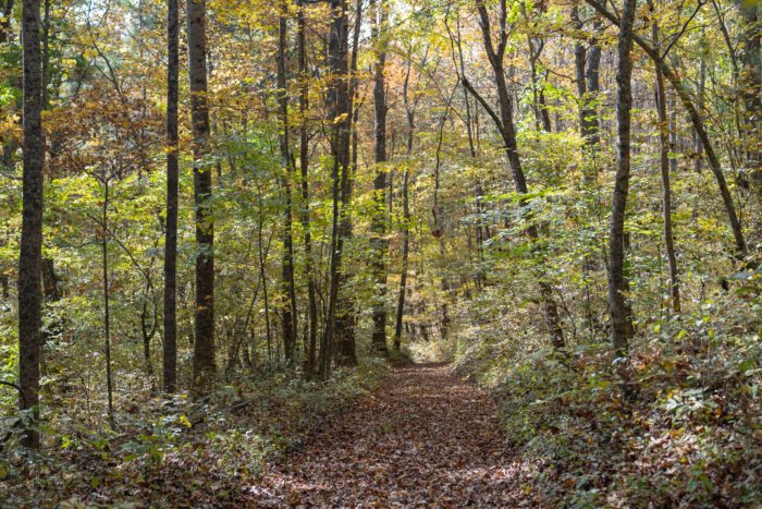
After a quick stop in Bland, I continued heading South. The end of Virginia suddenly felt like it was fast approaching. Fortunately, there was one final part of Virginia that I had been looking forward to since Day 1… The Grayson Highlands. The highlands wide open landscape and opportunity to see wild ponies allured me. This section was definitely one of my favorites of the trail so far!

Day 108 (20.1 miles)
It was a cold night. A thermometer read 28 degrees Fahrenheit. I drug myself out of bed at 7 am and to my surprise there was a fire going. Sasquatch had decided to make a fire when he couldn’t fall back asleep. There was no sun to warm us yet, but the fire was more than sufficient.
It took a lot of motivation to leave the fire behind and begin walking. A 2000 foot climb to start the morning. It was not as bad as the profile made it out to be, but I was happy when I made it to the top.

After a few more miles there was another, much steeper, climb. However, this climb led to a beautiful overlook and perfect spot for lunch. The cold morning had faded to a sunny day. I sat at the top for over two hours. Enjoying the views and soaking up the sunshine.

The back side of the mountain proved to be just as amazing. Seemingly endless views, along with a gradual descent into the valley.


At the bottom of the mountain was a large stream. The bridge to cross it had been wiped out by a flood. I navigated a tricky rock hop across the stream and managed to make it to the other side dry. Maine and NH prepared me well for this moment. The Knot Maul Shelter was just up a small gradual ascent. I took my time and arrived in the early evening. The shelter sat no more than 10 feet from the trail, which meant no extra walking.

Knot Maul Shelter: T2, S3, P2, W5, B2
Total Score: 120
Day 109 (19.3 miles)
I woke up to the sound of the others packing up. I figured it was time to get up and moving. The morning was full of small hills and farm pastures. The lower elevations somehow felt colder than the higher ones. A thick layer of dew covered the tall grass. My feet and legs were quickly soaked. It was a calm and peaceful morning. I passed by some cows and a few other hikers, but mostly spent the morning alone.
I also passed by the 3/4 to Springer sign! It honestly didn’t feel real. I’ve been on the trail for a while, but I finally felt like I had made some serious progress.

About 15 miles into the day, I came to a road crossing with a few gas stations. There was also a Mexican Restaurant attached to one of them. I stuffed my face with food and then resupplied at the gas stations. The GA boys did the same and we came up with a plan to get us to Damascus. We then packed out a few beers and headed another 5 miles to the Chatfield Shelter. We had another fire and told more stories. It was great to have good company and some beautiful weather!
Chatfield Shelter: T1, S2, P2, W1, B2
Total Score: 8
Day 110 (26.0 miles)
A full bladder forced me to wake up around 2:30 am. I had a tough time falling back asleep. I ended up getting up around 6:30 am. It is much easier to get started when it isn’t freezing outside. There were no fuel canisters for sale at the gas stations. I was nearly out of fuel and wanted to save my remaining gas for dinner. I drank a mediocre cup of cold instant coffee. I found it amusing that I have spent money to have a hot coffee be chilled into an iced coffee while not on trail. Unfortunately, that amusement faded when I realized I couldn’t just order a hot coffee instead of the one that sat in front of me. Nonetheless, the caffeine rushed through my veins and produced the necessary movements of my morning routine.

It was a gorgeous and warm Fall day. Strong winds blew loose leaves from the trees. At times I would be surrounded by a whirlwind of yellow, red and orange! I attempted to capture the moments, but my photography skills couldn’t do them justice.
I met up with the GA boys at the Mt. Rogers HQ. There was a change in plans for some of us. Sasquatch decided to push further up the mountain this day, in order to get a jump on the rain expected for the following day. I decided to do the same, but the other boys stuck with the original plan. It was a long and tiring afternoon. I took a quick lunch at the Trimpi Shelter and refilled my water. I had already gone 17 miles and there were 9 more to go. My feet were sore and my legs were tired, but I pushed on anyway.

Eventually, I made it to the Hurricane Mountain Shelter. A section hiker, Mike, was already there and had a fire going. I immediately sparked up a conversation, thanking him for the fire. He told me that he was heading home the following day. Out of sheer luck and kindness, he offered me his almost full fuel canister. I was elated to no longer drink cold coffee! He had actually lost his cook pot and hadn’t used much of the fuel during his trip. In exchange for his fuel, I offered to heat him up some water in my pot so that he could have a hot dinner. Sometimes everything just works out!
Hurricane Shelter: T1, S2, P2, W1, B1
Total Score: 4
Day 111 (16.0 miles)
It was a lazy morning. I slept in well past sunrise. The weather forecast said that it was supposed to rain all night and into the morning. This ended up not being entirely true. It did rain overnight, but not that morning. In the end it didn’t matter. I wanted to give myself a proper amount of rest from the previous big day.
I got back on trail around 9 am. It was a warm cloudy morning. The majority of the day was spent ascending gradual trail, eventually surmounting to some amazing views. The first few hours were through forests, but I eventually came to a pasture. There were large long horn cattle grazing there.

As I was passing through one of the gates, a man yelled something to me. It was windy in the open fields and I had a hard time hearing him. I turned around and headed back his way. He was in camouflage and was out hunting deer earlier that morning. We chatted for a bit and he offered me a beer, nothing like a cold one at 11 am.
I continued down the trail, some rain came and went. It wasn’t enough to soak through my layers, just some light rain. A few miles later and I arrived at the Grayson Highlands State Park. There was a shelter near a creek shortly after entering. I took a lunch break there and waited for the rain to stop. The next 5 miles of trail were said to be gorgeous and I knew the afternoon was supposed to clear up.

I began hiking again around 3 pm. The skies were partly cloudy, but I could see some blue. I was hoping to see the wild ponies that roam this area. Unfortunately, I think the rain drove them to bed down. I didn’t see a single pony, but this just gives me a reason to come back! The views in this section were magnificent. I hiked slowly and took way too many pictures.


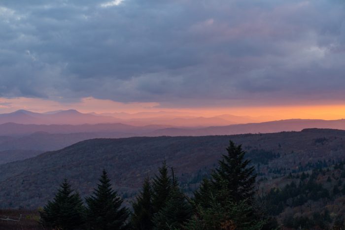
I ended my day at the Thomas Knob Shelter. It was a double decker shelter that claims to fit 16 people. It sits proudly above 5000 ft. in elevation and has a spectacular location for sunset. Sasquatch and I decided to stay in the upper level. It was completely enclosed and provided good protection from the prevailing winds. I sat on some nearby rocks and watched the sunset… enjoy!


Thomas Knob Shelter: T1, S1, P4, W1, B3
Total Score: 12
Day 112 (18.9 miles)
A very cold night with some mice to keep me warm. The shelter did a great job at blocking the wind, but it still got well below freezing in there. The morning sun was much needed! I froze my ass off while using the privy and finishing the last few miles of the highlands. The views were awesome, but still no ponies.


The air soon began to heat up. It wasn’t warm but it was a great temperature for hiking. I walked slightly downhill and then along a ridge for a couple miles. I soon found myself at Buzzard Rock, the last good view before descending Mt. Rogers.


I descended thousands of feet. Down down down into the valley I went. Towards the bottom was a beautiful creek and a bike path that paralleled it. The fall colors had brought hundreds of families to the area, riding down the level gravel path. A few young boys called me a “Mega Chad” when I walked past them. I don’t know what that means, but I can only assume it was a genuine complement to my appearance.
A few more miles led me to the Saunders Shelter. It was a quarter mile off the trail and nestled in a pine tree forest. The water was further down the trail. Just a trickle coming through some rocks. The plastic pipe to funnel the water was removed. I spent a half hour reinstalling the pipe to make it functional once again. I then relaxed for the rest of the evening. It was a quiet and much warmer night. Not even a mouse to disturb my sleep.
Saunders Shelter: T1, S2, P2, W2, B2
Total Score: 16
Thank you for reading this trail update! I hope you enjoyed the pictures and stories from along the way. The nights are getting colder but the views are getting better. My motivation is only increasing as I get closer to Springer. Until my next post, remember to keep wandering in your own direction!

This website contains affiliate links, which means The Trek may receive a percentage of any product or service you purchase using the links in the articles or advertisements. The buyer pays the same price as they would otherwise, and your purchase helps to support The Trek's ongoing goal to serve you quality backpacking advice and information. Thanks for your support!
To learn more, please visit the About This Site page.

Comments 10
Beautiful pictures, Drew!
Thank you, I really appreciate that!
Drew excellent pics! You convey the beauty of these sections well ,,as well as the spontaneity and fluidity of distance hiking. I have spent slot of time rehiking and these Va sections. Take care of your body and rest when needed. I miss the trail having hiked it 3 times in 80s. It still is magical despite ballooning popularity. The clarity of your photos show some of your talent and feel you could be a professional photographer. Take care 2 Spirits
Thank you 2 Spirits! That means a lot to me and I’m glad you enjoyed the post!
Love the pictures Drew. Always fun to read anothers impressions of trails I have hiked. The longhorn cattle were a surprise to me as well. Stayed a bit at Turner Knob and summited Mt. Rogers. Safe travels and best of trail luck to you
Thank you, I really appreciate the kind words!
If you/theTrek cares…Your posts are showing up as green category, and not as yellow category Appalachian trail. Which btw makes me think, why doesn’t the trek make the AT category color an off-white to align with the blazes…
I have tried looking into this and it seems my app may have an issue. I’ll keep trying to figure it out… I appreciate the insight.
Love the pics, especially the sunset ones.
Stay warm.