 ">
">
Luna’s Blessing
Day 12 (16 mi)
Waking Up Chocco
It was very cold last night with a low of 20, but thankfully I was warm in my sleeping bag. Being in Choccolocco shelter helped. It always feels warmer on the ground than in my hammock, likely because of conduction being less efficient than convection.
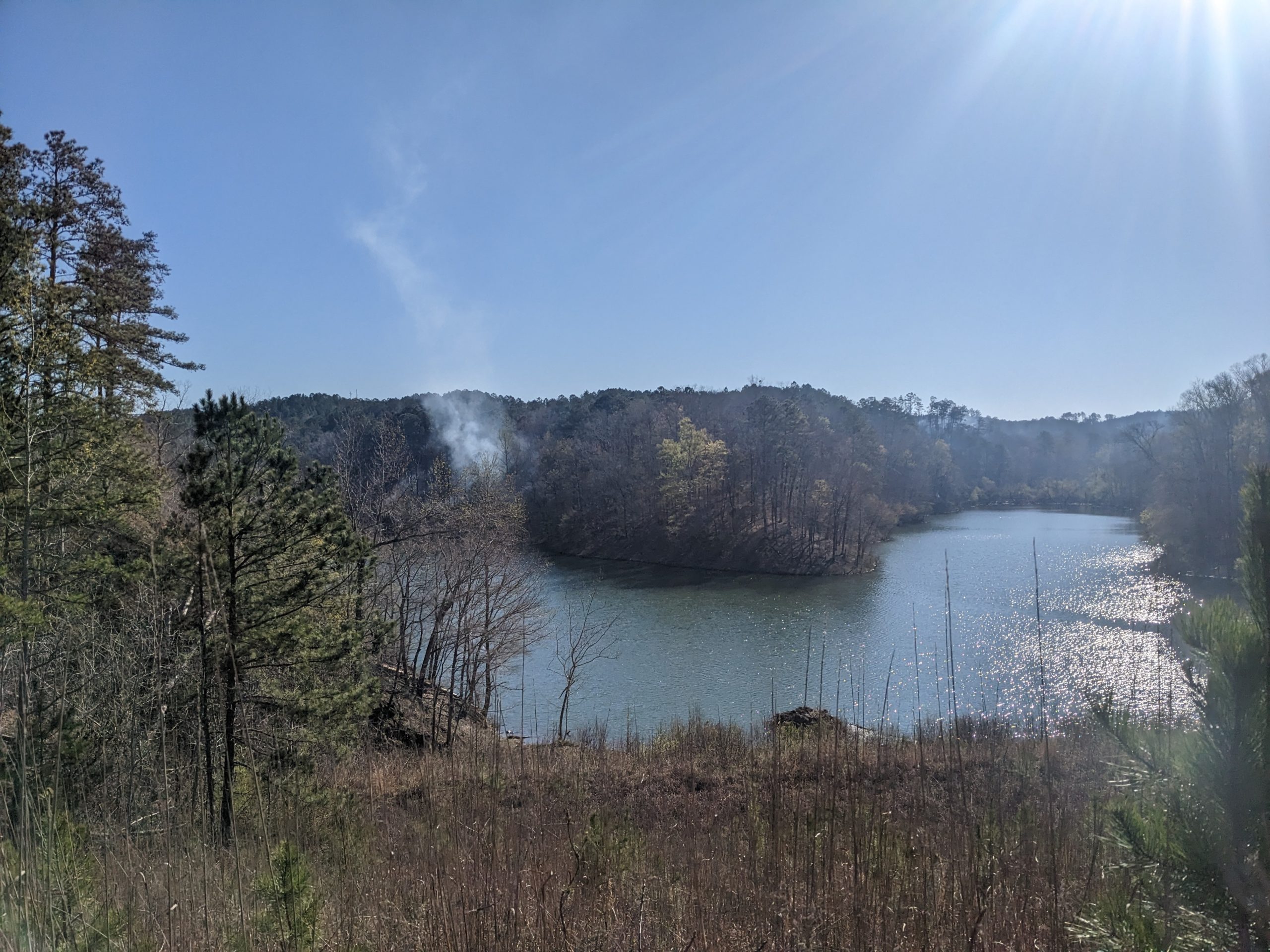
To start the day I got a nice look at Choccolocco Number 2 Dam and the lake nearby the shelter. There was a small plume of smoke from some smoldering woods on the far side of the lake.
Everything changed when the fire nation attacked
Wildflowers of the Day
Woodland phlox and trilliums lining the trail made for a pleasant downhill to Burns Trailhead. Star chickweed and rue anemone made a pleasant walk up Dugger Mountain.

Some flavor of phlox. I had difficulty identifying which kind. Plant Net said Santa Fe or threadleaf phlox, but both of those look to be west coast flowers, so not sure about the accuracy
Terrapin Creek Watershed Dam 31
The hike down Duggar and over to Terrapin Creek Watershed Dam 31 was relatively uneventful, but the dam and lake continues to be one of the most reliably solid views along the Pinhoti.

Who knew Alabama had mountains? Certainly not me before I saw them for myself!
There was a field of dead baby oak trees, which slightly confused me. They looked intentionally spaced in a grid, so maybe a forest service research project

Maybe they’re just dormant for the winter and are still alive?
Early Dusk Luna
On my way up the Oakey mountain ridge, I saw one of the nicest moths I’ve seen before, a luna moth.
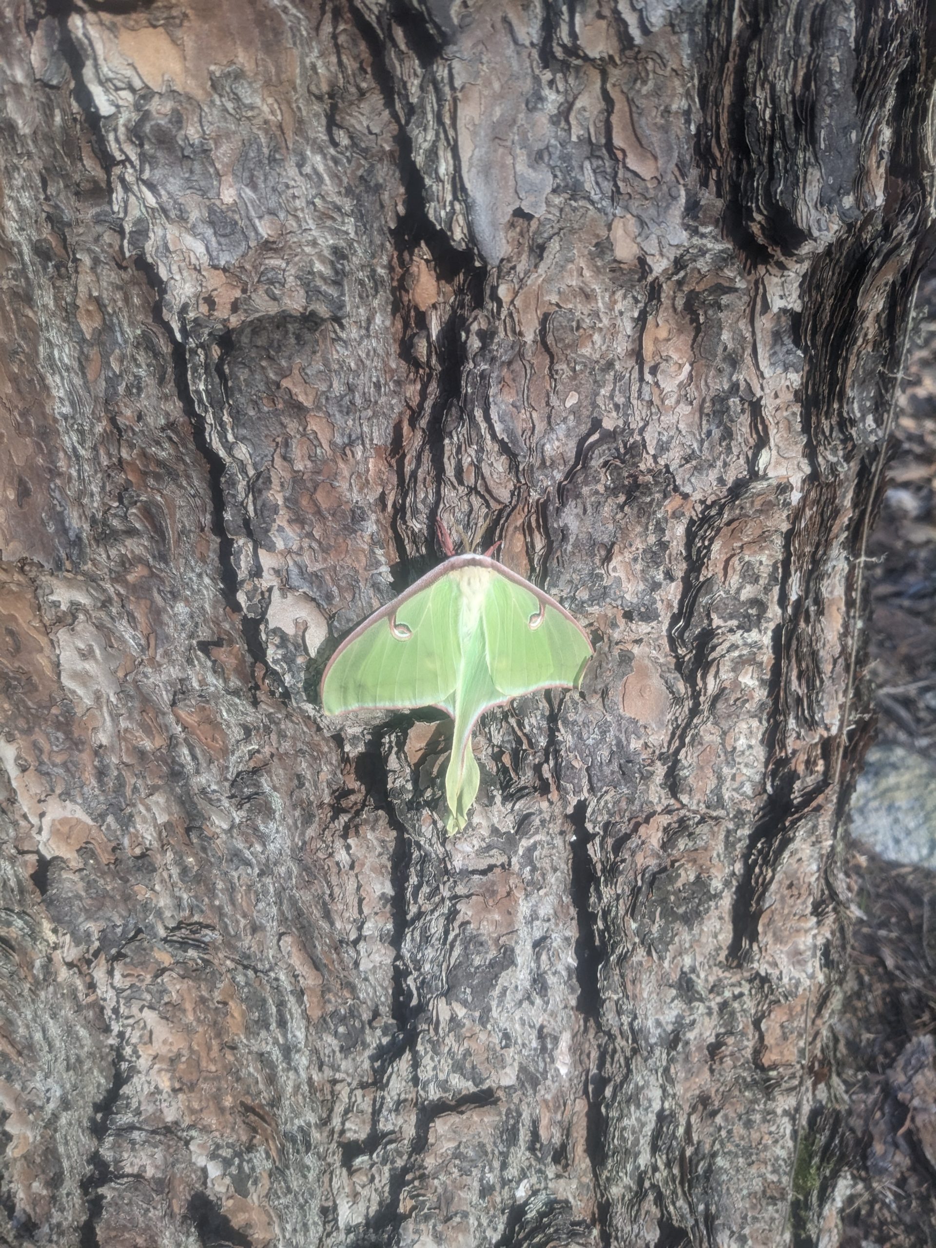
It tried to trick me into overlooking it by looking like a leaf. Cool leaves interest me almost as much as cool moths, so no dice!
Luna moths only live for a week in their adult form because they don’t have any way to eat. Couple that with being nocturnal forest creatures, and they can be difficult to find despite being a rather populous species. They rely heavily on camouflage, with green leaf-like wings lined in a darker brown that can look like a twig. It’s said to be a sign of good luck to find one during the day, so here’s hoping this isn’t the only one I spot.
I’m Not the Only One Out Here!
I got to Oakey mountain shelter around 8:30pm, right after dark fell, and to my surprise there were two other thru hikers there! One was sleeping inside the shelter and the other had a tent set up just outside it. This was the first time I saw other people at a shelter so far, and the first thru hikers I met since around mile 25, over a hundred miles back. It was late at night and both were sleeping so I set my hammock up to the side so as not to disturb them. I tried to do it discreetly, but couldn’t help but crunch on some dry leaf litter left over from last autumn. Hopefully I did it quietly enough not to disturb either of them.
Day 13 (18 mi)
Missed Connections
By the time I woke up the person sleeping in the shelter was gone and the person in the tent was not yet awake. I signed the trail register in the shelter and went on my way. The only entry from yesterday was Squirrel, whose name I’ve seen on registers for almost a week now always a day or two ahead.
On the two or so miles the rest of the way down from Oakey, there were numerous forest service property monuments. Seems like this section abuts private land.
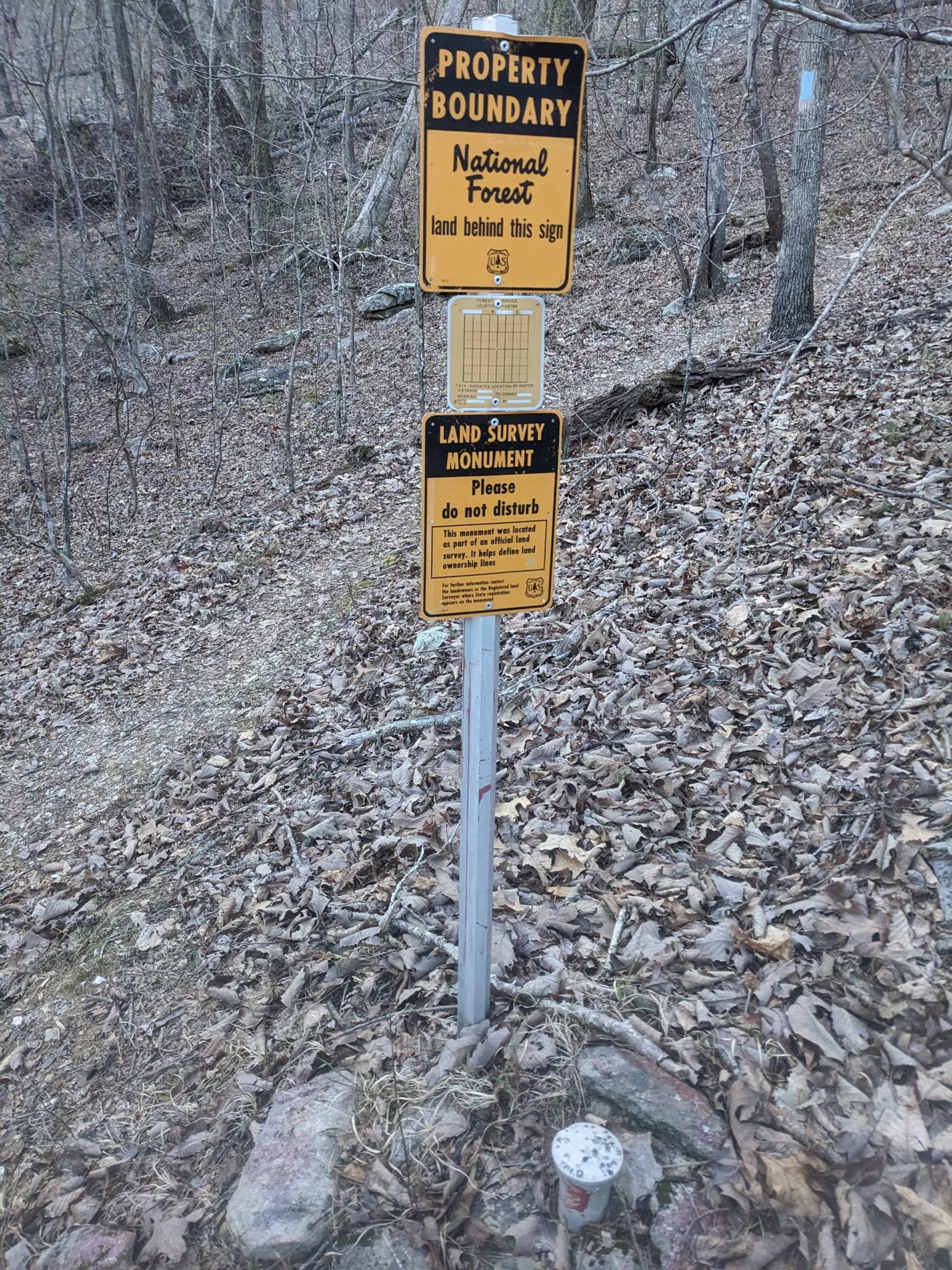
There had to be at least a dozen of these
Chief Ladiga Rail Trail
The Pinhoti intersects the Chief Ladiga Rail Trail for around a half mile. Just long enough for the flatter and easier terrain to be a good break while not overstaying its welcome and getting monotonous.

A scenic bridge on the rail trail crossing Terrapin Creek
Augusta Mine Ridge
The trail soon returns to more standard Alabama woodland, heading up and over Wilson Ridge and then meandering along Augusta Mine Ridge passing through mixed longleaf pine conifers and deciduous forests along the way. It will be very welcome when I reach rougher parts of the Appalachians with more ups and downs. I can appreciate some foothills, especially getting to see them grow in real time into more proper mountains, but I would be lying if I said they were as enjoyable as mountains. Walking on flatter and shallower graded areas is just not as exciting as more consistent elevation changes and viewpoints.
I stopped for lunch along Augusta Mine Ridge and who I assume was the tenter at the shelter yesterday passed me, but he didn’t make conversation. I was off trail a decent bit so he may not have even seen me. A bee came by to say hi and was enthralled with my water bottle. I don’t know what about it did it for the bee, but for almost 15 minutes straight it kept crawling along. Before I moved on I poured out a capfull of water on a leaf in case that’s what the bee was after. My other leading theory is the bee though the colors of the label was a flower.
First Other Hiker in 125 Miles
A couple hours later I caught up to the thru hiker who was sleeping inside the lean-to, who was Squirrel. It was good to finally put a name to a face I’ve seen so many times in trail registers! He’s around 60 and in fantastic shape for his age. He’s been pulling 15s the past few days and can keep a fairly brisk pace.
He asked me where the next resupply is, and said he hasn’t had one since all the way back at mile 21. This slightly amazed me, as we were at around mile 150 at the time and next resupply is Cave Spring, GA at mile 188. I don’t know that I could handle 160 miles off a single resupply myself. It wasn’t for lack of option either; he saw the Cheaha and Heflin spurs at mile 85 and 111 and decided he was good to go without them. He’s also aiming for Maine, so it’s likely I’ll run into him more in the future.
And Another One!
Squirrel went on his way as I filtered water, and soon after the thru hiker staying in the tent by the shelter came to the dirt road I was sitting by. His name was Leo, and he’s setting his sights on a thru of the Pinhoti. He said he’s been struggling a bit lately and still working on building his trail legs, so he was planning to stop at the shelter in half a mile. I was basically done filtering by the time Leo showed up, so we didn’t chat much beyond pleasantries before I was on my way.
Upon reaching Davis Mountain shelter, I saw Squirrel talking to three people staying the night there. Squirrel was just starting on his way again as I arrived. I had already gotten more social engagement than I had in the past week combined and was content to let further discussion wait until if and when we met up later, so I said hi to the three staying at Davis Mountain shelter but not much more. I asked for the shelter trail register and upon hearing there wasn’t one, I was ready to be on my way as well.
Abandoned Pit Mines
The trail in this area passed over private land that contained ample amounts of what looked like mountain bike or ATV paths, but being a weekday nobody was around using them. It also went through sections of iron ore pit mines. The area is named Augusta Mine Ridge because long ago there were iron boom towns in the area and fairly extensive mining operations. Those days are long gone now, however, and the former boom towns are now ghost towns. The former mines sparsely visited country and near wilderness.

The red in this picture is from hematite, a form of iron ore
Hawkins Hollow
Immediately before Hawkins Hollow the trail passed by a lake (more of a pond really) and descended rather steeply. There was a ladder available, but I didn’t trust it seeing it wasn’t bolted in place fully and could move from side to side.

Not included: 5.5 miles to Georgia, 6 miles to Spring Creek Shelter
I was still feeling good by the time I got to the shelter at 5 with almost 3 hours of daylight still to go, so I figured I’d give it a shot pushing into Georgia and could always hammock earlier if I ran out of light. Squirrel stayed at Hawkins Hollow and I wished him a good night as I pushed on.
Indian Ridge
Along the way up Indian Ridge was multiple solid views. The Pinhoti Trail Alliance guide I was going by says you could see back to Davis Mountain 2.6 miles away, Augusta Mine Ridge 11.6 miles away, Oakey Mountain 18.7 miles away, and Duggar Mountain 25.7 miles away (all trail miles, not straight-line) but I couldn’t identify them.

To the left of this view just barely extends into Georgia
I ended up stopping at Flag Pole mountain for the night, around 2 miles before Spring Creek shelter and 1 mile before the Georgia border.

A lovely dusk haze from Flag Pole

This website contains affiliate links, which means The Trek may receive a percentage of any product or service you purchase using the links in the articles or advertisements. The buyer pays the same price as they would otherwise, and your purchase helps to support The Trek's ongoing goal to serve you quality backpacking advice and information. Thanks for your support!
To learn more, please visit the About This Site page.

Comments 1
Thoroughly enjoy your posts, especially your attention to and knowledge of nature’s offerings. Best of luck