 ">
">
Massanutten Loop Trail: A 70-Mile Ridgeline Challenge in Northern Virginia
Nestled along a ridgeline in Northern Virginia sits a little-known trail called the Massanutten Loop Trail. The trail has great views that have to be earned by bursts of elevation gain, resulting in some seriously tired quads.
The trail traces its origins all the way back to the origins of the United States. A portion of the trail was constructed as an escape path should the Continental Army suffer defeat at the battle of Yorktown. This portion of the trail was created by Daniel Morgan at the direction of George Washington, known as Morgan’s Road. The 71-mile loop trail was finished in June 2002.
Massanutten Loop Trail At-a-Glance

- Length: 70 miles
- Location: Virginia
- Trail Type: Loop
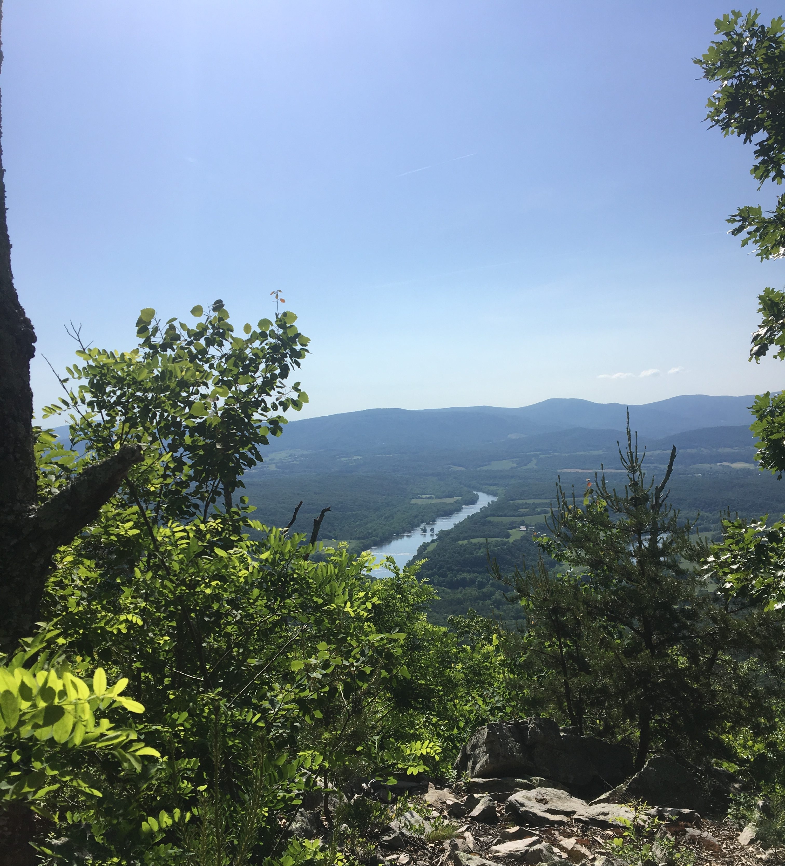
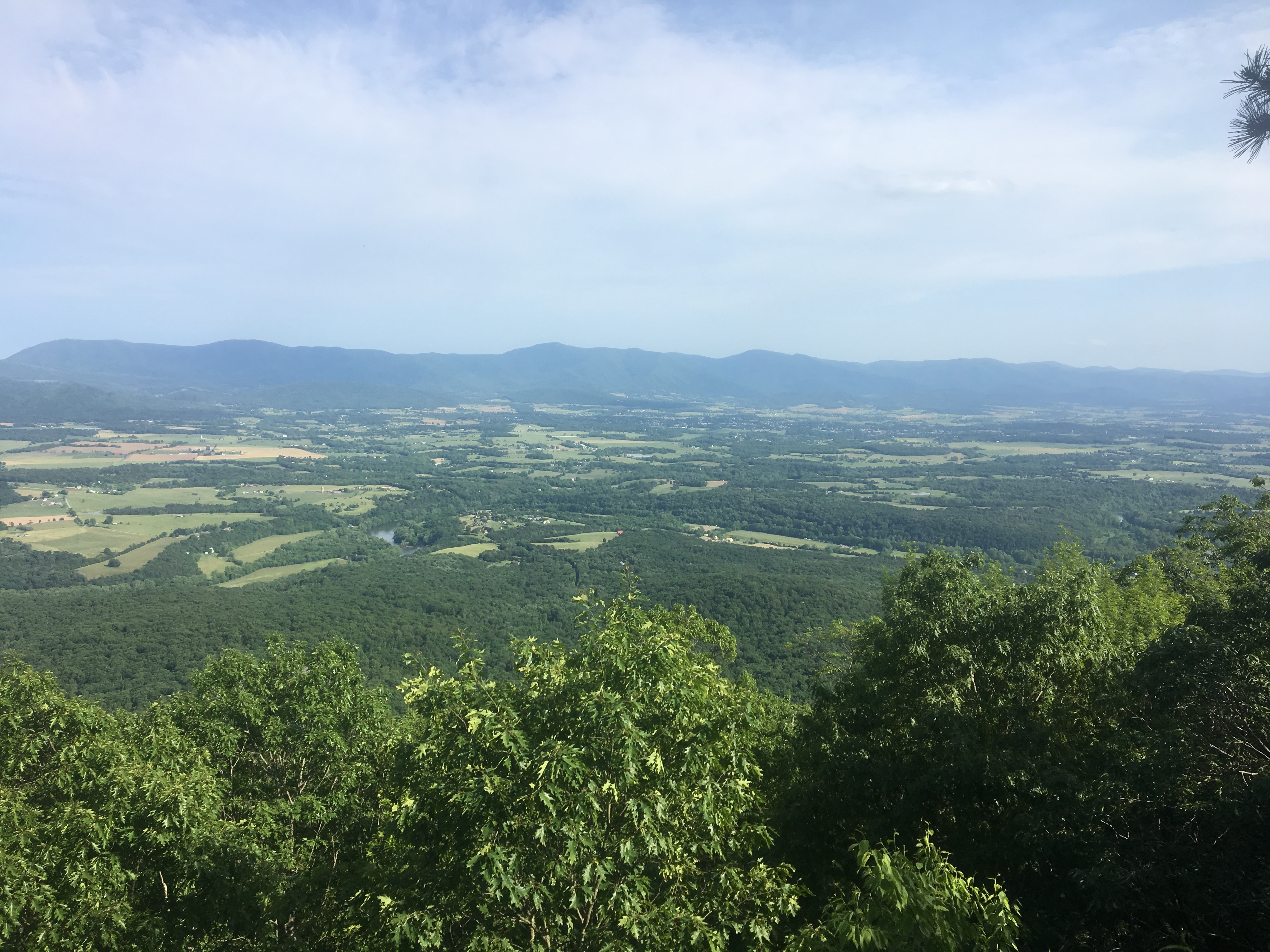
- Scenery: Beautiful ridgeline views of Shenandoah National Park to the east and Great North Mountain. Views of the towns in the surrounding valleys.
- Terrain: Difficult. This trail combines several climbs from gap areas with long waterless stretches daily. These two factors in combination make water management a key to your success and overall enjoyment of this trail.
Note: The difficulty rating is even applicable for experienced hikers. Careful planning should always take place when dealing with water management in the backcountry. - Navigation: The trail is well blazed and I didn’t have any issues with navigation. Be careful at intersections, as there are quite a few on the loop.
- Trail maps available
- Hiking Project Link
- Trail History
Getting There
Drive to Fort Valley, VA, the day before and spend the night at Elizabeth Furnace Family Campground.
This campground has several tent areas with picnic tables and fire pits for $16/night. The area also has drinking water and a restroom facility for those wanting one last proper seat on a throne prior to embarking on their hike. There is also camping across the road from the campsite. The camp hosts close the gate at around 9 p.m. and don’t open until 8 a.m. Unload your gear, then park across the street if you plan to start early.
I parked my car at the parking lot at Signal Knob, a short drive from Elizabeth Furnace Campground. Parking at Signal Knob Trail trailhead is away from the road and my car was fine for the three days I was out.
Direction
This loop trail can be hiked either clockwise (start going south at Signal Knob) or counterclockwise (start with the climb up Signal Knob).
Notes on a Clockwise Hike
Hiking the trail clockwise, you will start with a moderate grade out of Signal Knob. There is a great water source about five miles from the Signal Knob parking.
Little Crease Shelter
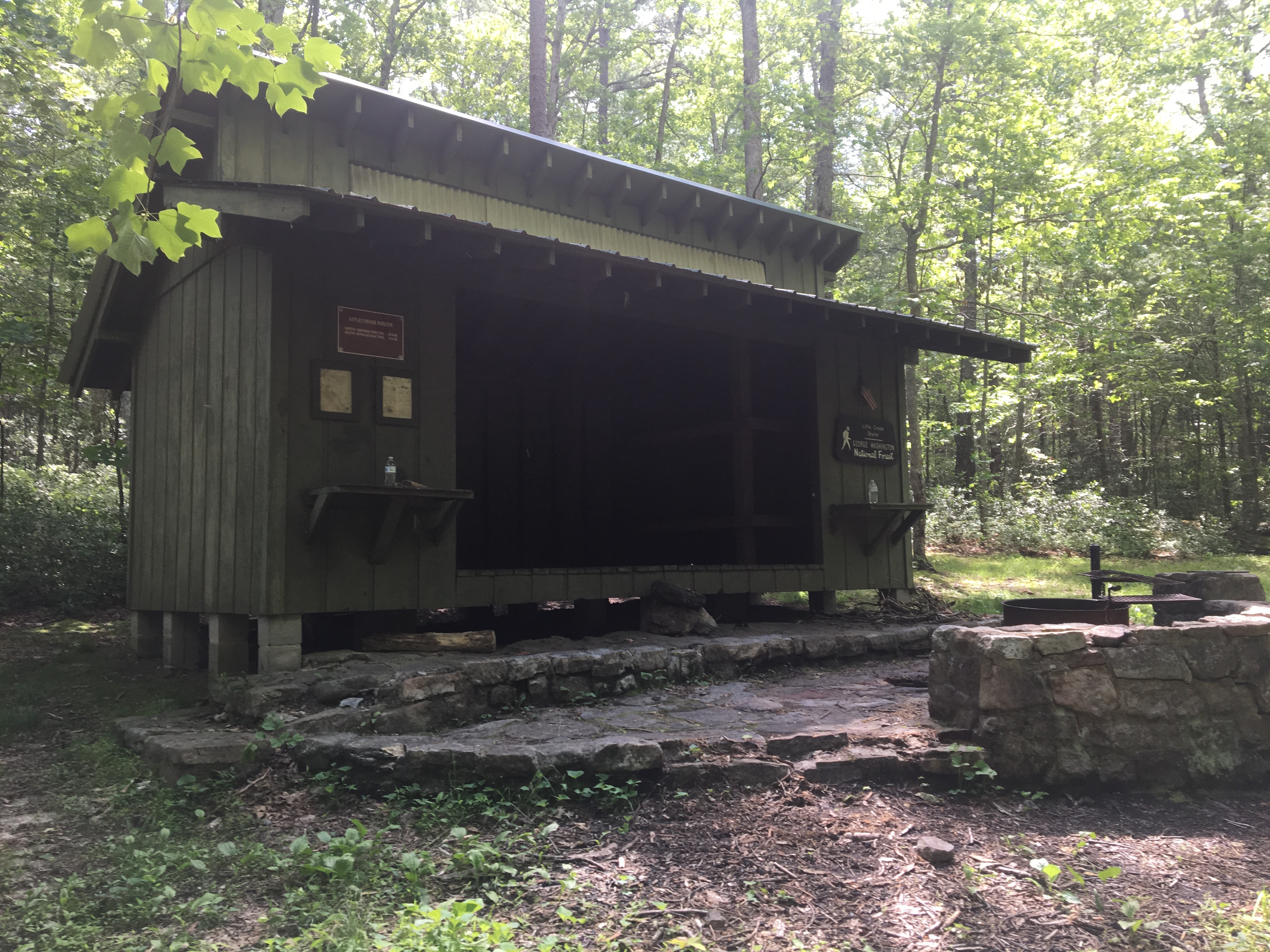
At around seven miles, the Little Crease Shelter provides a nice area for a break and to stock up on water. After the Little Crease Shelter, the trail again climbs moderately up to the ridge and then remains up on the ridge for about 15.5 miles. Be prepared to either dry camp or make it to the next water, which is at Camp Roosevelt, a Forest Service campground with water and facilities for $18/night.
Duncan

This is a gradual graded logging road that cuts back a few times until at the highest point of the section. After you get to the gap feature on the other side of Duncan, you are set up for Waterfall, the steepest climb of the entire hike at mile 32. This name is slightly misleading as you are expecting a glorious waterfall when in reality all you get is 30% grade for a short steep ascent. After Waterfall, there are two more gradual ridge line climbs until you get to an area for ATV parking.
ATV Parking
There is an excellent pipe spring 0.5 miles down the paved road the trail crosses. Be careful as the road to get down has no shoulder and most cars didn’t move over for me. There are stealth camping spots at the ATV area and I recommend camping here to stock up on water.
After you leave the ATV camping area, you climb out of Edinburg Gap. After cresting the hill you being a gradual downhill. At the base, you start the climb to the top of Signal Knob. After Signal Knob, several more miles of rocky downhill lead back to the parking lot for the completion of the loop.
Notes on a Counterclockwise Hike
Advantages
- Going Down Waterfall instead of up.
- See Signal Knob on the first day.
- See Woodstock fire tower on the first day.
Disadvantages
- Steep climb up to Signal Knob to start hike.
- Steeper climb up side of Duncan.
Why Hike This Trail
This trail is would be a great shakedown hike for an Appalachian Trail thru-hike. It combines rolling ridgelines that dip into deep gaps, and offers plenty of chances to work on your water management strategies. It shares terrain features you will see in Virginia, Pennsylvania, and farther north. The difficulty of the trail will likely keep crowds to a minimum.
Climate and Weather

Predicting weather in VA is tough. Be ready for rainstorms in the summer months and possible colder nights if you choose to hike in fall or winter. The best time for this hike would be from September until April. If you do it in the warmer months, bring tick removal gear and be on the lookout for black bears. We saw one black bear and a lot of bear signs. Sun exposure wasn’t too bad, but bringing a hat and sunscreen for protection isn’t a bad idea.
Gear Suggestions
- Water Carry Capacity
- Be able to carry at least 5L for dry camping
- Tick Concerns
- Treated clothes with permethrin
- Tick removal device; I used tick key
- Daily tick checks
- Posion Ivy
- Lots of poison ivy around
- Try to avoid it; carry first aid if needed
- Trekking poles
- Added motivation for hills
- Added stability for downhill sections
Camping

- Elizabeth Furnace Family Campground
- $16/night tent sites, water, flush toilets, trash cans
- Little Crease Shelter
- Large AT-style shelter with wooden bunk bed platforms, fire pit, water, bear pole
- Camp Roosevelt
- $18/night tent sites, water, flush toilets, trash cans
- ATV parking area
- Reliable pipe spring nearby, stealth camping
- Stealth camping along the trail
There are a large number of campsites on the trail. Dispersed camping is allowed in George Washington National Forest except in certain areas. These areas are defined here.
If you decide to camp on the trail, make sure to follow all Leave No Trace principles and leave the area better than you found it. For me this includes packing out at least one piece of trash per day and ALWAYS packing out toilet paper. The amount of toilet paper I see on trails is way too high, so I at least make sure I’m not contributing to to problem and I hope you consider it as well.
Massanutten Loop Trail Highlights

- Elizabeth Furnace
- Blast furnace used to make pig iron. There are a few interactive boards with descriptions of the area at the beginning of the hike.
- Camp Roosevelt
- First Civilian Construction Corps Camp in the nation (1933).
- Woodstock Fire Tower
- Awesome 360-degree views of the surrounding area; short walk from trail.
- Signal Knob
- Scenic views; used as lookout and signal point by Union and Confederate soldiers during the Civil War.
Water Sources

Surprise trail magic water… don’t depend on it, though.
- Elizabeth Furnace Family Campground
- Pump with potable water
- Water at mile five going CW (N38.885292,W78.335747)
- Strong flowing stream
- Little Crease Shelter (N38.869895,W78.360122)
- Strong flowing stream
- Camp Roosevelt (N38.727909,W78.515021)
- Water fountain with potable water
- ATV parking (N38.934163,W78.320321)
- Reliable pipe spring 0.5 down the road
- Passage Creek
- Guidebook suggests not drinking out of it. I drank 4L filtered.
- Seasonal streams and creeks
- A few smaller seasonal springs and creeks formed by runoff that may be available.
Resupply Options

Given the length of this trail, all food supplies can be carried. If you wanted to do a resupply it would be best to have two cars and park one at the parking area you want to grab resupply at.
- Fort Valley Country Store
- There is a little country store that has a deli on the road to Signal Knob trailhead.
- Fox’s Den Pizza
- Sunday, AYCE salad bar and pizza with drink $6.99 (Front Royal, VA).
- Pizza dough was possibly homemade and was delicious.
- They will make whatever kind of pizza you want and put on buffet.
Closing Thoughts

This loop was a challenging adventure for 2.5 days in May, but the views and satisfaction of that AYCE pizza made it worth it. Water is the single biggest challenge of the trail, followed by a few steep ascents. Again, this would be a great shakedown hike for the AT or another long-distance trail.
Short trail log in video form below.

This website contains affiliate links, which means The Trek may receive a percentage of any product or service you purchase using the links in the articles or advertisements. The buyer pays the same price as they would otherwise, and your purchase helps to support The Trek's ongoing goal to serve you quality backpacking advice and information. Thanks for your support!
To learn more, please visit the About This Site page.

Comments 3
Oh Hell Yah! Nice work Twospeed!
Good trip report, notes, and video; and of course, was a genuine pleasure to hike this hike with you!
The ATV Coordinates are incorrect (ATV parking (N38.934163,W78.320321)) . I believe that location is the Signal Knob Trailhead Parking.
The Edinburg Gap ATV Trailhead off VA 675 is: 38.788791,-78.521561
Per the to Topo maps, the spring SE (Towards Kings Crossing) from the saddle on VA675 is located at: 38.783201,-78.513127
Thanks for the info I got the GPs coordinates straight from my gamin so some of the numbers and locations could’ve been miss transposed.