 ">
">
Meet Muir Way Maps [And an Exclusive GIVEAWAY!]
The following is a sponsored post courtesy of Muir-Way.com, a producer of beautiful maps of mountain ranges across the country.
Muir Way are maps like you’ve never seen. Creator Jared Prince started muir-way.com in 2013, releasing colorful designs of 20 National Park posters based on the maps given out at each park’s Ranger Stations. Those 20 original designs have grown to a catalog of 65 National Park posters from USA and Canada, all available in their 20 color palettes. Maps are printed at their shop in California, and they strive to use materials made in the USA, including the paper, canvas, and wood used to make the prints.
The company grew from there. In 2014, they added the Historical Series, which includes reproduction prints of USGS and other vintage maps from the early to mid 1900’s. In 2015 they introduced the TOPO Series: mountain resorts which used contour lines to depict landscape. Last year saw the addition of Hydrological Maps. These appealed to the river rats, depicting every river, stream, and lake in the US and Canada.
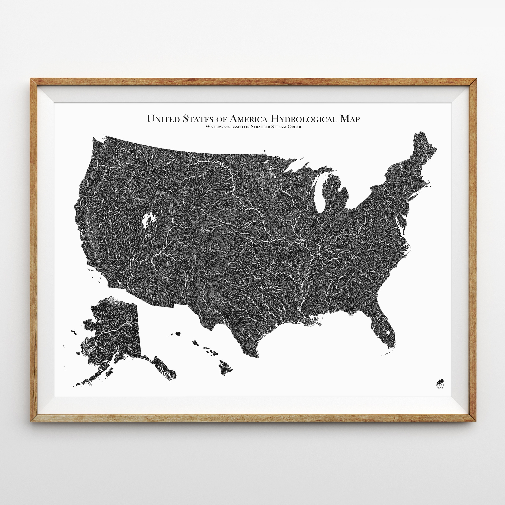
Framed hydrological map of the US
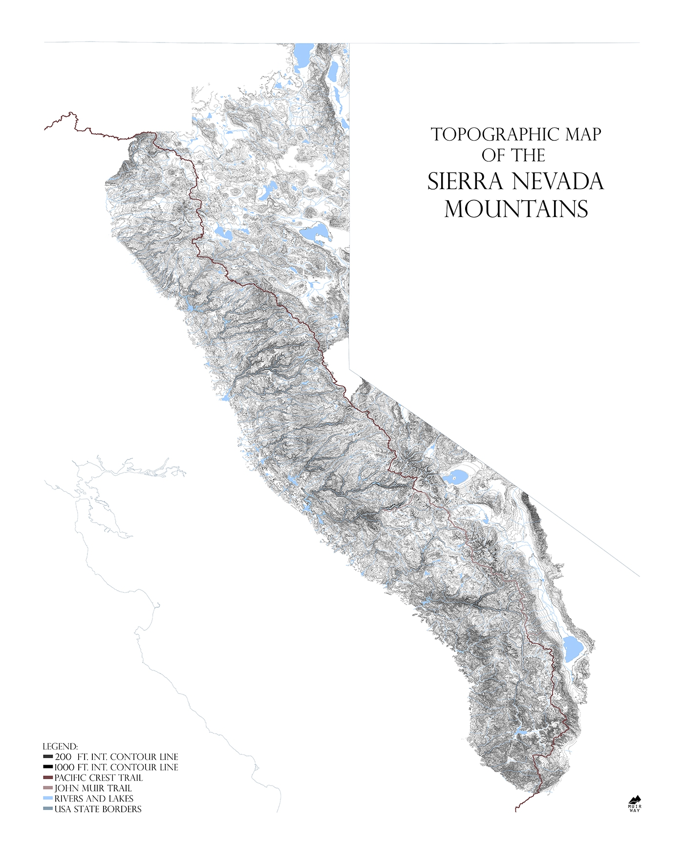
This brings us to the Range Series. These incredibly detailed and complete topographic maps show entire mountain ranges… among the most detailed maps out there. Each one was created using hundreds of smaller quadrant maps from the USGS and then stitched together digitally.

Closeup of the Range Series: Sierra Nevada
These beautiful maps had so much data that they had to drastically simplify them just so they could be printed and still look aesthetically pleasing… something you would want to hang on your wall. The original USGS maps had contour lines with 20 to 40 foot intervals which, when placed together and sized to fit onto a single print, would completely fill in the outline of the mountain ranges because there were so many contour lines.
The maps are meant as art pieces to represent the places we love. The aim is to keep them simple and beautiful by only including contour lines, rivers and lakes, the most iconic trails, and state/country borders for perspective. Each map is printed on 24×30 inch archival textured art paper, or as a 24×30 inch canvas gallery wrap.
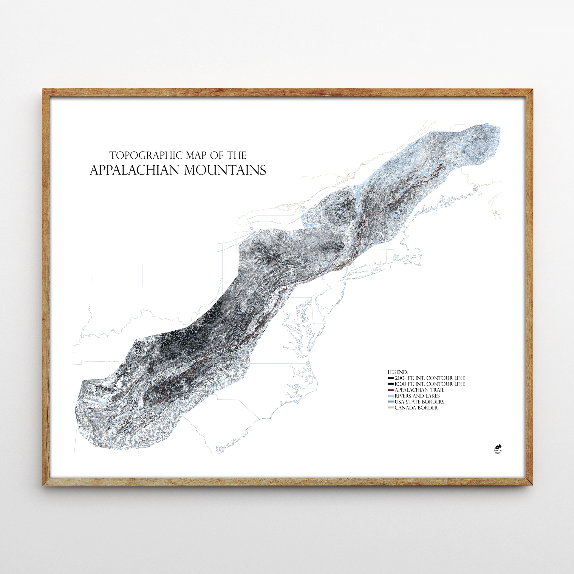
Framed topographical map of the Appalachian Trail
In keeping aligned with the progressive values of the outdoor industry, a portion of sales from Muir-way is donated to the Sierra Club Foundation to help protect our land, air, and water. The maps have been featured in national magazines and websites around the world such as Outside Magazine and Gear Patrol, as well as on the walls of REI’s around the country.
THE GIVEAWAY
We’ve teamed up with Muir Way to give away 8 maps (more than $1,000 worth of product!).
Here’s how you can win:
- Comment below letting us know which map you’d prefer (Appalachian or Sierra), and why.
- In your comment also let Muir-Way.com know what mountain range you’d like to see them offer next.
That’s it!
EIGHT winners will be selected on 3/29/2017 and notified by 5pm EST on 3/30/2017 via email (the email included in your comment). Prizes will only be shipped within the continental USA.
All maps are from the new Range Series, and measure 24″ x 30″. Canvas gallery wraps are valued at $249, art paper prints are valued at $89.
GIVEAWAY ITEMS: Appalachian Mountains
Three (3) on archival art paper, one (1) on canvas gallery wrap

GIVEAWAY ITEMS: Sierra Nevada Mountains
Three (3) on archival art paper, on one (1) canvas gallery wrap
Rules: No purchase necessary. Prizes will only be shipped to the continental USA. Contest entry date is valid starting 3/15/2017, 2017 at 8am EST and will close at 3/29/2017, 2017 10pm EST. Winner will be notified via email on 3/30/2017, 2017 4pm EST. By commenting on this post, you give permission to share your email address with muir-way.com.

This website contains affiliate links, which means The Trek may receive a percentage of any product or service you purchase using the links in the articles or advertisements. The buyer pays the same price as they would otherwise, and your purchase helps to support The Trek's ongoing goal to serve you quality backpacking advice and information. Thanks for your support!
To learn more, please visit the About This Site page.

Comments 142
Would love the Appalachian Map, As I have been an avid hiker all my life and I live in NY, very close to the AT. I am beginning a trek next year on March 14th on the AT, My boss is allowing me to take off for 6 months and he is sponsoring me to walk, yesterday was the 1 year mark until I leave. That’s why am on this site, researching a few things about the trail before my journey. I hope I win. I have hiked in numerous places in South America, and parts of the PCT, as well as parts of the AT, but my dream is the entire AT on 1 journey one end to the other. I would like to see a map of the Continental divide as it is another trail I would like to conquer.
Thanks Jon Silvestri
Totally into the Appalachian one! We just bought a house and are planning a gear room/office. Currently the plan is to frame an AT map I got at Neel gap. This would be a much classier solution! We have plans to section hike the trail over time.
Would love for my 21yr old son who is currently on a thru hike, just left Gatlinburg yesterday due to weather! We keep up by big maps and sending his drop boxes… but would love to find him some cool maps like this to have! The Himalayas would be a cool next map!
Thanks guys.
I’m a proud owner of Muir Way”s Portland Historical Series Map. I would love to add the Appalachian trail map to my collection since I am now 3000 miles away on the West coast and would love a beautiful reminder of all the weekend warrior trips I would take through the Whites, Shenandoah, North Georgia, and the likes. Oh how I miss having this awesome trail right in my backyard.
Muir Way, it would be awesome to see topo maps of individual mountains stylized as beautifully as all your other maps. I’d specifically love to see Mt. Hood and Mt. Washington. Thanks a ton for your beautiful work!
This is awesome! I would love the AT map as I am currently attempting a Thru-hike with my dad (follow us at IG: @DadAndDaughterNoBo). We started at Springer on March 12 and didn’t make it too far before Winter Storm Stella forced us off the mountain. We are walking a bit slower than we’d like but trying to be safe and smart until we hopefully find our trail legs. I think it could be cool to have some big frame of all 3 trails with a Triple Crowner logo or something like that since I’ve met a few people on the trail who are trying to Triple Crown. Or also, offering the map in another style like this gold foil version of NYC: https://www.minted.com/product/foil-pressed-wall-art/MIN-2KV-GFA/new-york-city-map?source=pla&utm_medium=sem&utm_source=google&utm_sub=pla&utm_campaign=G_S_Art_PLA_USA_Beta&utm_content=&utm_cs=9f99f8&utm_int=a&utm_keyword=&utm_device=a&gclid=CPvy4NP02NICFRY9gQodY1UD6A&color=A&shape=
Happy hiking y’all!
I would love to have this for my 21yr old son…! He’s currently on a thru hike now, they just left Gatlinburg yesterday while waiting out deep snow, they got a police escort off the Mt,lol.. but they also dropped them off at 5 guys. His mom and I are getting maps of the AT, one to help us keep up with his location, and two, we want to give him a nice map when he’s done! I would also like to see one of the Himalayas, that would be cool….! Thanks guys.
I’d like to Appalachian range topo map to remind me of my 2016 AT thru hike and the mountains I love. I think it would be pretty sweet to see a MuirWay topo of the Himalayas or Alps.
The Sierra map. I hiked the JM trail two summers ago and think about it often. I love the mountains and maps. I love how maps are storytellers in their own way and it helps me remember my own stories of where I’ve been and the beautiful things I’ve seen. I would love to hang it in my classroom at school where I teach high school Geography.
I would love to see the CDT map also.
These look amazing! I would love to hang the Sierra map on my wall. My bedroom wall is a veritable collage of maps of all kinds, but most are of various mountain ranges and trails I’ve hiked. Waking up to see that map every morning would be a great piece of motivation in the last few months before heading out for the PCT!
Hey Muir Way maps, how about some love for the Midwest!? Adding a topo map to the Badlands collection would be awesome!
Fantastic looking maps! I’d love the Appalachian range; planning my NOBO hike for next spring and seeing those mountains hanging on my wall would give me daily inspiration to keep on top of my preparations.
As far as other sets of mountains goes, I’d love to see the Himalayan range if you ever decide to expand beyond North American mountains. Everest is on my bucket list too!
I would like the Appalachian Trail map to show my friends where I’m thru-hiking! I think it would be great for y’all to do the Patagonia mountain range in Chile next!
I would love the AT map. I live 10 miles away from the trail, and it’s my “local” hiking area!
Muir Way, I just checked out your website, and all of your maps are gorgeous! I am starting a flip-flop thru-hike of the A.T. with my father on May 1, and I would love to win an Appalachian map so I can leave it behind for my mom since she’s been so supportive of our hike.
I would love for you to make a map of the Teton Range. Thanks for this opportunity!
1) The Appalachian map would be amazing, I would love to just sit and look at it as a way of guiding my memories
2)This is a long shot, since I’m sure they’d prefer to stick with US mountains for now, but I would love to see a poster like this of Mt Fuji. My grandmother had a painting of Fuji in her living room when I was growing up and it’s always a calming image for me
I would love to have the Appalachian map, as I am thru-hiking the Appalachian Trail this year!
As far as what would be awesome to see next, definitely the Himalayas!
Definitely Appalachian Mountains. I’m from WV and live up in the foothills of them. I think for the next piece should be Mt Rainier… reason being is my wife and I summited the mountain on our honeymoon. So it has a special significance for us. Cheers!
Would love the Appalachian map! A map of the White Mountains of NH would be great.
Wow, what gorgeous maps. I would love to have one of the maps of the Appalachian Trail, to commemorate my thru-hike attempt in 2015. I had such an amazing journey along those paths – I even got engaged on the trail! And if I won one of these beautiful maps, I could display it at my wedding this summer. It would be a nice nod to coming full circle!
I think a Muir Way Map of the Big South Fork River & Recreation Area would be really cool, but that’s a pretty niche answer so I know it’s not top of the list. I spent my summer there, though, so it holds a special place in my heart. And if you go outside of the US, a map of the Andes would be awesome!
Thanks for running this giveaway!
Appalachian trail map because as a thru hiker I survived almost getting eaten by a bear and a stress fracture to finish. Good times.
I’d love the AT map. From that perspective I should be able to see all the blood, sweat and tears I left on the trail in 2014.
I would love the Map of The Appalachian Mountains, I am in the midst of planning a Thru hike starting on March 10th 2018 NOBO.
Things are going great at the moment, training walks ,visits to the gym and taking advice from Friends that have done this one of a kind Hike,Iam busy checking out all the pieces of gear I shall need, again taking advice from friends and my Local Trailwalkers store.
Florida is kind of hard to train in, no hills but we have lots of multi story carparks with stairs and a good gym, going to Trail Days and also a training hike in October on the AT .
I originally did my sailboat for a single handed sail around the world but fell in love, I will be 70 years old when I start in March and it will be 25 years since coming to the USA, Hiking the AT will be something to share, my wife can visit and check my progress allowing her to show friends where I am on the Trail.
Thanks for a chance to win a fine piece of Art .
Trail name “Crazy Brit “
Love the Appalachian Range Map! Grew up in them and currently thru hiking them! It would go right in the living room for everyone to see! For another mountain range, I would like to see the Unaka range. It’s in NC/TN but a very interesting area!
I would love the AT map. I start on 4/29 this year and plan on finishing by 9/15 or so. It would be a very cool item to have at home so my wife can follow my trek.
I think you should do Philmont Scout Ranch in New Mexico next. It is part of the Sangre De Cristo mountain range. That would sell like hotcakes with the scouters and you would have a built in buying base from decades of scouters going to Philmont. The history of Waite Phillips and Philmont is legendary and it deserves a map of your caliber. Further, many youth get their introduction to hiking and backpacking, and more importantly LNT policies, through Philmont that carries on with them the rest of their lives and they go on to do these other iconic trails.
Thank you for your consideration.
Scott Edwards
Wow these are AMAZING! I love the map of the Appalachians. The AT was the first Long Distance trail I hiked and will always have a special meaning to me. If I had a beautiful topographical map like this I’d display it alongside my framed 2000 miler certificate. 🙂 It would be a wall of beauty.
If I’m not mistaken, the tallest range in the Continental US is the Rockies. That would be an awesome map! Some day I’ll hike that too!
I would def’ly like the Appalachian Mtns map for two reasons: first, I was born and raised in the foothills of the Cherokee National Forest in northeast Tennessee and second, I know how to say “Appalachian” properly. I moved farther south for a few years but missed my mountains too much and moved back about 12 years ago. I’ve been enjoying these mountains with my wife as our collection of waterfall pics will attest. I would love to thru-hike the AT but parenting responsibilities make that unlikely. We have been able to get our younger children onto the mountains and onto the trail for short hikes. I hope they’ll grow up loving those mountains as much as I do.
A closer detailed map of the Blue Ridge Mountains would also be nice.
Would love the Appalachian Range map! Grew up in NH on Lake Winnepesaukee and my parents and grandfather took us hiking often into the White Mountains and that’s how I first learned of the Appalachian Trail. Now many many moons later (and retired), I’m finally putting my teenage dream into motion by section hiking the AT.
I would love a detailed section of strictly the White Mountains in NH – that’s where my heart will always be.
I would love the map of the Appalachian Trail. I maintain a section of the trail in the 100 mile wilderness area in Maine. I love doing this work and all the hiking involved. Although I would love to thru-hike, I believe that I will tackle it in sections. Thanks for the opportunity to win this beautiful map!!!
Maybe a map of the White Mountains in New Hampshire?? That is where I hike usually – I am at 44 of the 48 peaks!!! It is a spectacular area to hike in!!
Thanks!!! 🙂
These maps are absolutely beautiful! I love using maps as art, and spend lots of time staring at the ones on my walls and dreaming of future adventures. I thru-hiked the AT in 2015, and those mountains are incredibly close to my heart. That being said, I’d love the map of the Sierra so that I can spend time poring over it and thinking about my future PCT thru-hike.
I live in Asheville, NC and would love to see a map of the nearby Black Mountain range. It’s an impressive chain that includes Mt. Mitchell, the East’s highest peak.
Thanks!
I would love to have the Appalachian Trail map as I dream of a future AT thru hike. Perhaps it will push me to break out of section hiking the AT.
I would like the Sierra Range Map. I hope to hike the JMT someday with my son’s. I am from SD so a map of The Black Hills of SD would be great. Highest Peak in the US East of Rockies is Black Elk Peak, formerly Harney Peak. 7,244 ft. Next highest East is in the Pyrenees in Europe.
I’d take the Sierras!
And I’d love to see the Wasatch Mountain Range in Utah
Appalachian. In our mid-40s, my two college roommates and I are starting to section hike the AT in April. A long-held dream too long deferred by life. A beautiful map like this would be a great keepsake to keep that spirit going over the next several years.
I would absolutely love the Appalachian Mountain rage map! I’m fortunate enough to live in the north west corner of CT in a town that the AT passes through. I’m day hiking or doing some over nights on my little section of the AT at least once weekly (well, when there’s not two feet of snow on the ground), and am planning some section hikes for the Ny- New England stretch for the coming season. One day I hope to do a through hike.
I would also love to see a map of the Andes Mountains as well. I hope to one day be able to hike some sections of this iconic range as well.
Would love the AT print. I live in Harrisonburg Virginia and am currently about 1/2 done with hiking the Virginia portion. Would be fascinated to see something similar for the San Juan Mtns in Colorado.
I’d love an Appalachian map. Our family hiked parts of the AT trail last year in each state that it passed through as part of the AT 100 challenge. It was an amazing experience. For the Muir War map, I suggest the Blue Ridge Mountains (I know they’re part of the Appalachians but they’re also great in their own right).
1) The map of the Sierras. I keep thinking about the phrase that got drilled into me on the AT, “hike your own hike” which for me means having the courage to live your dreams. One of my dreams is to hike the PCT and I’d love to have a map to hone my focus and cheer me on!
2) The Alaska Range. Seeing Denali was one of the best moments of my life and Alaska is so close to my heart. I’d love to see one of your maps capture that range.
The Appalachian Range map! All of my family lives in the awesome little trail town of Pearisburg, VA. I’ve spent many an adventure hiking and playing between Bland County and Shennendoah. Many of us at some point have either worked in the motels near the trail, or provided rides and trail magic for hikers coming off of Angel’s Rest. I’m the only one that no longer lives in the area, and I miss it every day. So I would love the map to hang on my wall, it would be a nice reminder of home. I would love to see a detailed map of the Brooks Range or Talkeetna Mountains in Alaska. I spent some time there back in 2013, and was awed by the high, craggy peaks of the Talkeetna mountains, and then the similarities between my Appalachian mountains and the Brooks Range.
1) I would love the Appalachian Trail map! I thru-hiked Northbound in 2015 and have continued to stay involved in the Appalachian Trail Community via way of backpacking, volunteering, and trail magic. This would be a great reminder of the (still) unbelievable adventure I had, and its a beautiful work of art.
2) For new map, I think a detailed topo of the entire White Mountains would be great (and would sell well, given how popular the region is). I would definitely pick up one of those!
1. I’d love the Appalachian map because each detail of the mountains would bring back so many memories from my hike.
2. The next range I’d suggest is the Cascade Range to connect to the Sierra for the PCT.
Appalachian… it is home and my happiness.
Would love to see The Whites as a map,
Would love the Appalachian one. After my 2015 thru hike, I moved away from the mountians a bit, and am always needing a visual reminder of the most important trip of my life so far.
-2015 trail name Roker
I’d love the Appalachian map. I thru-hiked in 2015 and can’t stop thinking about it.
I’ll suggest the Adirondack Mountains.
This is awesome, thank you for doing this! I would love either… but if I have to choose, then the Sierra! The AT was my first thru hike and the area will always have a special place in my heart, but geographically the Appalachians just can’t compare to the great mountains out west!
In another print, I’d love to see the Alps, maybe the area around Mont Blanc. Lots of high peaks and varied terrain, I think it would make for quite a beautiful print. Plus the hiking over there is hard as hell, and it never hurts to be reminded of your weaknesses 😀
1) I would love a copy of the Appalachian Range Map. I thru-hiked in 2016 and have an affinity for maps. I carried hard copies of maps during my entire hike, never relying on technology.
2) I would love to see a Range Map of the Andes to commemorate my time spent there while serving in the Peace Corps.
These maps are the business! And the Sierra map makes my heart smile. Spent many summers playing in those mountains.
Maps of the North Cascades would also be really cool. Especially the Goat Rocks Wilderness area.
Cheers
I’d LOVE the Appalachian map! As a New Yorker, I’ve spent a great deal of time exploring the Appalachians. I have so many great memories from over the years. I’ve also worked VERY hard towards achieving my goal of hiking the entire AT. I am so proud to say that next year it is finally happening!! I am finally at the right point in my life, not only financially, but emotionally and physically as well. I am beyond excited (and nervous), but mostly excited!
I’d love to see a map of the Rocky Mountain Range done next. Most of my hiking has been done locally, due to financial reasons, but 4 years ago I was able to treat myself to a 5 day hiking trip in the Colorado Rocky Mountains and it was the most incredible experience. It was my first time seeing mountains that massive in person. Absolutely breathtaking!
Oh yeah, I have one last great reason why I think I should get the map. My birthday is on March 29th!!!! This would be THE BEST birthday gift! ?
I’d love the Appalachian one. I hope they make one of the Green Mountains of Vermont.
Appalachian range is the range where I live and have spent most of my life, so would love that map. Would love to see a subset of the Blue Ridge.
I’d love a map of the Appalachian Trail, primarily because I’m currently on it. Actually I’m just off trail warming up at a lodge (wifi! Time to blog), but I’d love to hang something on the wall after this hike to commemorate it.
Honestly so many ranges are already done. I was going to say Zion or the Shennies, but they’re both already listed. You guys and gals are crushing it!
I’d love the AT Map…I’ll be starting my thru-hike in 2019 and would love this to hang on my wall as daily motivation!! I’d love to see the Blud Ridge Mtn., GA and the Cumberland Plateau range in Middle TN!!!
June 30, 2016 I embarked on a southbound thru hike of the Appalachian Trail. It took me 5 months and 22 days to complete and I was lucky enough that the school district I work for gave me a leave of absence to pursue the incredible adventure. Upon returning to the classroom I have been working on incorporating the trail in the curriculum. I would love one of these maps of the Appalachian Trail to help my urban middle schoolers better understand the magnitude of the trip, and hopefully inspire a new generation of adventurers!
I’d love one of the Sierra maps reminds me of trips out west camping and hiking as a kid. The next map should be of the Rocky Mountains.
I’d love a map of the Sierra. I’ve loved maps my whole life, and have come to appreciate them even more throughout my backcountry travels, because I am a technological moron and would probably lose a GPS unit if I had one. And then I’d need a map to find it.
The Sierra was one of my favorite parts of my PCT hike, and a place I want to get back to, so a map of it on my wall would be both a reminder of a hike and motivation for another one.
I’d like to see the CDT route through Colorado, or possibly just the Wind River Range in Wyoming.
I would want the Sierra one, because I love both mountains, but “Range of Light” is what’s tattooed on my body… (one of the many beautiful ways Muir referred to the Sierra Nevada) My home mountains <3 (let's be honest though, I would love the Appalachian one as well…)
I would love to see the California Coastal Range, as these are the mountains I have lived in my whole life… Perhaps if you wanted to focus more carefully, the region around Big Sur… 🙂
I would love to win the Sierra map because it’s where my daughter lives. In the future the Adirondaks would be great (my neck of “the woods”. Lol.
Hello, I would love the Appalachian Trail map. I grew up in New England and hiked often in my teens. My father passed three years ago, before my plan to hike the AT this year, starting April 11. He taught me to love the outdoors, mountains in particular. He would have loved to see that map.
I would love to see a map of the German/Austrian Alps. I was in Germany for 2.5 years and hiked there a few times. Just amazing vistas and rocks!!!
I would love the Appalachian map. I have grown up in Tennessee, where I am attending college at the University of Tennessee at Chattanooga. Here is where I found my love for the environment and my passion for conservation. These mountains are where I discovered my purpose. I am currently pursuing a degree in Biology and hope to continue my career in conservation biology. I would also love to see a map of the Rockies!
I would love to have the Appalachian Range map! I admire the simplistic, minimalist design and the map would serve as a visual reminder of not only the great times I had on the AT, but also all the obstacles that I overcame before, during, and after my hike. I think a map of the Brooks Range in Alaska would be a great addition to the Range Series. I’d recommend dedicating and releasing such a map in honor of John Muir’s multiple trips to Alaska.
Would love one of the maps of the Appalachian Range please. I really believe this would be something meaningful to cherish in the coming years after my 2019 hike. Have dreamt for many years of having the opportunity to do this and things are finally coming together that would allow me to make the hike a reality. This would totally be icing on the proverbial cake
I would love the High Sierra map. I grew up camping with my family in the Sierras and when I became an avid backpacker in my teens it was the Sierras I most often went to. Now at age 51 I am trying to get back in shape so I can return to backpacking in those amazing mountains. A map like this on my wall would only help inspire me to be honest.
I would love to see a map of the northern Sierras done this way or perhaps the entire PCT. That would be amazing. Regardless, these maps are wonderful. Well done.
Todd
I love the Sierra map. I thru hiked the PCT with my husband in 2016 and I loved the Sierra so much that I’m bringing my Mom this year to hike the JMT.
Would love to see the whole PCT section offered as a beautiful map.
Back in the 70’s my husband hiked for Kennedy meadows to the north end of Yosemite. When I met him in 1999 he was still saying that it was the most beautiful place he had ever seen in his entire life. In 2014 he passed away.
I’m working on a backpack trip to get him back up to the Sieras, a place I will probably not get back to. I’d love to have a splendid picture of where he is.
As for the future I would love to see one of the Rockies. Love my people in Colorado.
SIERRA!!! Because this is an amazing map that depicts one of the most amazing mountain ranges in the world! No matter what mountains I hike/climb around the world…I always come back to the diverse and beautiful Sierra Nevada! So grateful!!
I’d love a map of the Appalachian Mountains as I hiked the AT in 2014. I live in Utah now so I’d love to bring a piece of my east coast home into my new home. I think it would be a great conversation starter in regards to the art and awareness of the beautiful mountain range back east.
I would love the AT Map. As a future 2017 thru-hiker of the AT this would be personally enjoyable. However, as a high school science teacher who will be gone for a quarter away from my students while doing this, a map like this would be great for my classroom wall. I live in AZ and my students have a hard time conceptualizing what the environment of the east is like, let-alone, what it would even be like to hike through it. I want to inspire students to do the same – to escape the city and protect the wild. Maps I’d like to see next? – Grand Canyon (or if this is already done) OR the Madrean Sky Islands in northern Mexico up through southern AZ.
I’d love the map of the Appalachian mountains. It will help keep me sane on days when I’m trapped in the cube. I’d also love to see a topological map of Ilse Royal.
Hi! I would love a map of the Sierra’s. I am from the North East and have seen maps of the AT all over the place. I have not been exposed to the Sierra’s as much. Also, the John Muir Trail is in the Sierra’s, and he is one of the founding fathers of forestry, and I happen to share a birthday with him. April, 21. This map will also help inspire me to explore more of that area, and open eyes to a whole new world.
I am a self proclaimed map junkie. Im guilty of having multiple copies of every map i own. They end up being my journals, and all of them have the memories of the countless times ive looked upon them as i have purposely gotten “lost”, always wandering, exploring, and more times than not going well beyond the expected journey that life has put under my feet, just one step at a time. Ultimately, willingly working for and earning the adventures i seek. When friends and family ask me about why i always escape society, city life, and their norm? I just grab my most recent map; my journal, and show them where i expected the trip to take me but how it inevitability took me beyond my expectations. I go beyondering!!!
I would like a Sierra Map
I have to suggest my home territory, the wilderness and backcountry areas i grew up searching for and finding my path, overcoming the obstacles that were blocking the way, and now as still travel it on my path, i know its is worth every step!!! The Glacier-Wilderness Complex, roughly 2+ million acres in and around Glacier National Park and to the south in The Great Bear, Scapegoat, and Bob Marshall Wilderness Areas of The Rocky Mountains in Northwestern Montana.
I am torn between both beautiful maps. I was born and raised in the Appalachians of Tennessee. I have always been intrigued by our topography, and as a fisherman and hiker, I have seen many of the Appalachian wonders of nature. My late father, a transplanted jayhawker always joked around that our mountains weren’t real mountains, go west to see real mountains. I haven’t made it to the Sierra’s yet, but I enjoy thinking about those mountains and my father’s stories of them from his youth.
I would really love the AT map because that was the trail that started it all for me. Now that I’m hooked on long-distance hiking, I can see that my life has two distinct phases: pre and post AT.
I’d enjoy seeing a print of the Colorado Trail.
I would love on of those Appalachian maps!! I’m a AT thru hiker class of ’15, and I will be embarking on an unrelated precedented cross country bike ride/PCT thru hike/Mississippi thru paddle this coming year! You should do a map of the Rockies next! This stuff is so sick man! I would love a map to be able to look back on, that’s some real art!
Would love The Sierra map for my husband and 2 sons who hope to hike the JMT this summer. The map would be so helpful!
1. Hiking Katahdin at nine changed my life forever. I will never forget seeing a few hikers finish their last leg of the trail, Baxter Peak!! Twenty years later I exerienced the same victorious trek when I thru-hiked in 2012. The Appalachians are close to my heart, I would stare at that map forever and get lost in the topography!
2. Wind River range is a place of strong interest.
I would love to have the Appalachian map because I have read nearly every book on hiking the A.T. My dream is to be able to hike it before the Black Snake endangers it (fighting that pipeline, too). I wanted to write as I hiked. Yet, as I made notes from my readings and watched videos of through hikers to plan my own trip and worked out by hiking every day, my right leg started to cramp after just a little strenuous hiking on low impact trails through the woods to the lake near my house. I had this checked out and an ultrasound revealed an artery blockage which required a stent. With three TIAs occurring three years earlier due to partially carotid arteries, I am advised to do low impact hiking. I may never do enough of the AT to satisfy me, so to have its beauty over my writing desk would be a lovely gift. What should you map next? I would like to see Mt Ranier, which would remind me of my brother who loved that mountain. Thank you for all you do!
I’d love to hang the Appalachian range on my wall so I can re-live my thru hike every day! I think the Florida keys would be an interesting wall hanging!
the AT because I wish to do the trail next year
the John Muir would be my next choice
I would love the AT range map. I currently live in Vermont and the AT was my first long distance trail. The next map I think they should offer is the Cascade range.
I’d love the Appalachian map, because I live in PA and went to college in WV in the heart of the Appalachians. I think a map of the Andes would be really cool too – have always thought that’d be a part of the world I’d like to visit.
I love maps!! ..and these are very nice! I would love to have the Appalachian Mountains map. I grew up in southern Virginia and have spent my life playing in these mountains. Would be interested to see the northern Rocky Mountains (western Montana & Wyoming)
I’d love to have the Appalachian Mountains map. After hiking the AT in 2011, I rank the experience as one of my life’s highlights.. While I don’t need a reminder of it, I’d love to hang the map as a bit of a brag. I’d like to see you do a similar topographic map of the Catskill Mountains; I know you already have a Catskill poster, but it doesn’t have the same topographic features of these maps.
Maps! I study them, gaze at them, admire them, hang them on my walls. I simply love maps! The Sierra map to gaze at while preparing for my south bound Pacific Crest Trail hike this year would be my choice. I have my eye on the Absaroka Range, a smaller ranger of The Rockies and would like to see it offered on Muir-Way maps.
In 2016 my husband and I sold our house, a car and left our jobs in order to complete my life-long dream of thru-hiking the Appalachian Trail. We are a few hundred miles short of completion. We had too many bills that needed to be paid and have to re-enter the workforce in order to pay those bills. But, we dream about returning to the trail and have a daily yearning that makes it almost impossible to concentrate on anything else.
I would love the Appalachian map!
Hey everyone! Daddy Long Legs here!
First off, I’ve got to say how incredibly cool these are. These maps are amazingly detailed and I’ll be buying both regardless if I win or not. If I had to choose a single map I would have to choose the topographical map of the Appalachian Mountains. I fell in love with these mountains after spending an entire year of my life walking through them. I attempted my first thru hike in April 2015 but had to leave the trail in Massachusetts. In 2016 I was blessed to go back out there and complete my dream but not only mine. I was blessed to be able to complete a total strangers dream as well. His name was Paul and he passed away before he was able to set foot on the trail. I carried Paul’s boots from Georgia all the way to the top of Mount Katahdin, Maine last year completing both of our dreams to thru hike the AT in the process. So if I were to win I would send this map to his wife M’Lynn in Australia because I believe that she would really enjoy and cherish this.
I’m not sure if Muir Way Maps is looking outside the US for new mountain ranges but I would suggest the Southern Alps of New Zealand. The newly established Te Araroa trail is becoming increasingly popular and traverses Mount Cook, New Zealand’s highest mountain at 12,218ft.
Best of luck to everyone and a huge thank you to both the Trek and Muir Way Maps! Hikers Hike!
PS to the Trek.
I tried posting this yesterday thru my phone but was unable to. I’m not sure if it was to long but thought Id give you the heads up on that. In case anyone else was having that problem as well.
I would like the Appalachian map. I am an AT section hiker, and this would be great for visualizing the elevation of areas where I am planning on hiking. Also, maps are just cool in general.
defiantly the map of the AT. I have several maps of the AT, but my wife won’t let me hag them in the main living area – they “don’t fit” with everything else. However if i WON such a prestigious prize, and if it came in a box marked “fragile” she would have to let me hang it in a place of prominence.
Thank you!
-Paul
Oh Yeah, with me being Irish and it being St. Patrick’s day….. I have to win!
I love the look of these maps! A side hobby of mine is cartography. I’ve been reorganizing and an Appalachian map would go great with my gear room. I came off trail in ‘15 and had to have a double partial knee replacement. I would love to have this in the gear room to inspire me to keep pushing and get back out there and finish the dream!
The AT has been in my heart since I was 14….so the Appalachian range I would adore! Now that I am much older, it is still in my heart and I read all the books and blogs I can to live vicariously through others. My dream is to buy some land, near the AT, have a small cabin built and open a hostel for thru-hikers. My husband and I hike small sections here in east TN when we can. I would love to see close ups of the northern and southern terminus of the AT.
I would thoroughly enjoy either as I greatly appreciate both landscapes. But, if I had to choose one it would be the Sierra! The Tetons were the first mountains I got to experience off the east coast and will always hold a special place in my and many other’s hearts. So, that would be my pick for next maps. Thanks!
I would love to have the Appalachian map. I’ve always loved these mountains and next year on March 26th my 27th birthday Im going start my thru hike. I’ve always dreamt of doing this hike since I was a little kid. Two years ago I was trapped in a house fire and almost lost my life. From that point on I made a promise to myself to go for what I’ve always dreamt. This map will be a firm reminder of that and a constant motivation boost for me. As far as the next range I’d like to see one of the Great Smokey Mountains. Thanks so much!
I would love the Appalachian one! My girlfriend and I are planning a through hikes of the AT and as a geology major I love the Appalachians because of how old they are! I recommend for the next one you do to be the Alaska range. Alaska is my favorite state, and I think it would be awesome to see in such detail.
Noah Katz
These are so cool! I’m currently decorating my living room with oversized black and white prints of the Appalachian Trail from our 2016 thru hike! The only thing that’s missing? A super awesome BA topo map of the Appalachian Mountains! (And maybe a replica Katahdin sign? But I digress…)
My first love will always be the Appalachian Mountains, but it would be cool to see a map like this for the Rockies. Who knows? Maybe the CDT is in my future!
Defiently the Appalachain map.maybe a map of the smokies.
I would like to win the map of the the Appalachian Mountains because I live in Pennsylvania among these great beauties. I don’t know if I will ever thru-hike but have been on parts of the AT and feel a connection to the trail and all those that hike there. I’d like to see maps of the Pennsylvania State parks as I am trying to see every one and am collecting the small maps of those I visit. The Rockies are my pick for the next map of a mountain range. I have been to the Rockies many years ago and remember the feeling of awe when we could see the mountains many miles before we reached them. We thought we had seen mountains in the east but those western Rockies were mind blowing.
hey these are gorgeous maps!
Hard to choose between the two but I would love the Appalachian mountain range map!
keep up the good work!
Bunny
As a thru hiker (a few of ’em) and now budding teacher in West Virginia I try to inspire the children I teach about studying nature, appreciating the wild spaces around us, and conserving the beauty in the world. Having the Appalachian trail map, which includes where I live and teach in WV, would look great on our classroom wall and I know the kiddos would love to study the detailed elevation lines to better understand their place in the surround ecosystem. We have already done the ‘topo line’ exercise with mapping out our knuckles and this map would make the perfect addition to the Wild and Wonderful West Virginia corner in the classroom!
Great stuff!
Mike ‘Catnap’ Rankin
Trek, I need the Sierra map so I can have something to look forward to as I plan my PCT hike.
Honestly, I’d love to see the Atlantic Ocean mountain range. Diverse. Stunning. Vastly unknown. It’d make my day!
Wow, these are beautiful. I’d love the Appalachian Range print!
The maps both look great! I’d love to have the Appalachian one since that’s where I’ve done most of my hiking. I’ve never had the opportunity to hike it in sections for longer than 1 week at a time, but I would to conquer the whole thing one day!
Since you already have 2 of the 3 major trails in the U.S., it would be cool to make a map of the Continental Divide and be able to collect all 3!
Thanks for hosting the contest!
I would love to hang the Appalachian map right above my desk! I will be thru-hiking the AT next year and I have been planning since 2016. I am aiming for a triple crown but the AT is what started it for me and that is the most beautiful map I’ve seen by far!
I would love to have a map of the Sierra Nevada’s! I was born on the West Coast, but had to move to Florida with my family. I miss it so much, so to have a beautiful topography of those mountains, that keep calling me back, would be amazing. Those mountains mean so much to me, they are a part of who I am. I am constantly longing to be there, as they are home to me.
Thank you,
Dana
Hi! I choose the Appalachian map! Mt Katahdin is in my back yard! This would be such a gift for my business and myself.
I cannot remember a time in which there was not a globe in my house. As a child I would pull it out to figure out where all kinds of things were in relation to me. When I became obsessed with Sherpa’s I would run my hand across the Himalayan section of the globe amazed by how much higher the relief was here than on my own Appalachian Mountain section. I wondered what it would be like to climb them, how much harder it would be. Let’s keep in mind that this was in a pre-google age, so I couldn’t just go online and watch them in action on youtube. As I look at your maps I hope that I can display the Appalachian one in my classroom. I want to use it to inspire my students to get their heads out of there devises and their eyes on a real life paper map. In the future I would love to see a map of the Pyrenees… the GR10 was my first long distance trail.
I’d love a map of the Sierra I have enjoyed reading John Muir’s books over winter break and some day wish to hike the John Muir trail. I think the next mountain range should be the presidential range.
Thank you for offering these wonderful and beautiful maps to us all. I would like the Sierra Mountain Range map. My daughter is hiking the PCT this year (insert nervous sigh here)… I can imagine this map hanging in the kitchen, which is the hub of my house. I can see myself moving the small metal hiking figure up the range as she updates us on her current location. This map would be more than a decoration; it would be a conversation piece. As I look at it I will think of my beloved only daughter but more than that I will remember that one of the reasons that she is able to hike all this way alone is because her mother ex-patriated from Australia to England and England to America in the late 1960’s and early 70’s respectively. To me, this map shows that I have successfully passed down my love of the outdoors and travel to her.
Definitely the Appalachian. We live very close to Springer Mtn. I’ve seen many excellent suggestions for the next series. I would favor the topos of wilderness areas, such as Rich Mountain in Gilmer co. GA.
Thanks for the long shot, here!
Appalachian Mountains! Such a great piece of work.
Next project could be the Adirondack Mountains
I would love the Appalachian map! I just started hiking 1 year ago, 6 months after a total knee replacement. I’m planning to hike the GA section in May and having this map in my room would be great to encourage me too Lana thru hike!
I would live to have the Appalachian map, as the wife and I are planning on hiking it in a few years.
I think the Teton Range or the Rocky Mountains would be cool for the next ones.
I would be very grateful for an Appalachian map. I would love to see a map of the Continental Divide Trail.
I would love a Muir map of the Appalachian Trail to commemorate the journey my guy and I made in 2016. After six months on the AT, he proposed atop Wildcat Mountain, Peak A, overlooking Carter Dome in New Hampshire. Since returning from the trail, we have just purchased our first house, and would proudly and prominantly display this beautiful piece of art to make it a centerpiece in our home.
I’d love to have the Appalachian map because I walked the whole length of it last year! My thru-hike was one of the best times of my life and the map would be a nice momento of those memories to hang in my home.
Next, I’d like to see you make a map of the Southern Alps in New Zealand. I’ve been in NZ for the past 3 months and I’m in complete awe of the mountains here. It would make for a beautiful poster!
I’d love an Appalachian range map! I do lots of conservation work and the Appalachians are my home. It would be cool to see a map of the Andes mtns done in this style. Thanks!
I’d prefer the Appalachian poster, as I’ve grown up hiking all throughout this beautiful mountain range. I think that the Sangre de Christo mountains would be a wonderful candidate for your next print!
I’d prefer the AT map, as it begins/ends not too far from my house, and would like to section hike in the near future
Would love an Appalachian Trail map.. 2020 is it!! I will be 63, I have sectioned the past 5 yrs.. will be in Harper’s this year!! For 1/2 done.. but in 2020 I will do a thru hike God willing!! Would love the map!! For it flows in me now!!
While I reside on the East coast and am an avid weekend hiker in the Whites I’ve always wanted to go out west to hike. I have trail maps with wall tack hanging up around my apartment for inspiration to keep hiking and someday make it out to King’s Canyon and the rest of the Sierra’s. It the solitude in the mountains while hiking/backpacking that can bring happiness and completes me. So a stellar map of the Sierra’s would adorn my walls quiet swell with the other blown up photos from the whites.
As for ranges next on the list, the Mahoosuc Range would be pretty awesome. Lots of ups and downs. Heck the boulders seem like serious gains weaseling through them. But if you are going beyond North America, Patagonia would be pretty awesome. It’s on the hiking bucket list as with so many other naturally beautiful places around the world.
I would love the Appalachian Mountains map as my husband and I have hiked all but NH and ME and plan to finish them this summer! Since I live in NY and hike the Catskill Mountains frequently I would love to see a map of the Catskills! Thanks!
I love the Sierra map. That range sings to my soul. For the new map maybe a combo of the Cascades and Olympics.
Having a map of the Appalachian Trail on your wall. Gives daily inspiration on where you would like to be
I’d love to hang the Appalachian map on my man cave wall!! I’ll be hiking it next year and I’d LOVE to have it as motivation!!
Other maps . . . . the Cascades would be nice!!
Appalachian. I would like to see the smoky mtn. Range map.
I would love to be an owner of the Appalachian trail map piece! I’m currently a freshman in college and have the dream of graduating with an environmental studies degree and then taking six months off after graduation to hike the Appalachian trail!! Another piece I would love to see in the collection (I went through the website and couldn’t find one) would be a map of Muir Woods! Muir Woods is one of my favorite places, I went last year and cried upon seeing the trees. From that moment I knew that I wanted to dedicate my life to nature and protecting our environment! I absolutely love the idea for this project, what a great way to honor such beautiful and essential parts of our country!!
I was born and raised in the Appalachian mountains of North Georgia, my family took yearly trips to the Smokey Mountains when I was a kid but my heart is torn. My husband was born in Carson Valley, Nevada , moved to Georgia when he was three, but he spent his summers there growing up. We spent 6 months last year living and exploring the Sierras, this would be such an awesome gift for him. It would be the perfect piece of art for our new home here in Georgia!!! We would love the Sierra Map!!!! Thank you for the chance to win!!
I’d love the Appalachian Map since I’ve spent time out there back in my geology undergraduate years learning about geology and doing some geologic mapping. I have the large geologic map of the US hanging on my living room wall. This map would compliment it well. As an NC native, it would also be special.
I would love a map of the Sierra!
I would love to see the Cascades next!
why the Sierra and why me? Muir said it best: “I am hopelessly and forever a mountaineer. Civilization, and fever, and all the morbidness that has been hooted at me has not dimmed my glacial eye. And I care to live only to entice people to look at natures loveliness. My own special self means nothing. My feet have recovered their cunning. I feel myself again.”
– John Muir
I would love the AT map. I printed one on the plotter we have but it was 17 feet long. Not exactly a wall hanger. I love the trail and everything about it. Thanks and keep up the good work!
I would love one of the gorgeous Appalachian maps as a gift for my dada, a retired Army civil engineer. This would be right up his alley, and a great way for him to follow my 2017 thru hike.
I’d love to have AT map to adore.
Ive gotten immersed into nature because hiking through any type of natural settings have been proven to reduce our stress level. Having adventures in the wild also brings us all closer to the nature in means of inner-self exploration. I had a wonderful and unforgettable experiences camping and hiking through AT trail in Tennessee and NC last fall, before the fire. Explored through ghost town and stargazing is one of great adventures AT have to offer to everyone.
I’d love to have AT map to adore, Ive hiked AT trail. It was one of the most unforgettable experiences I had..
I’ve gotten immersed into nature because hiking through any type of natural settings have been proven to reduce our stress level considerably. Having adventures in the wild also brings us all closer to the nature in means of inner-self exploration and recognize the fragility of Earth’s eco-system.
My yellow-lab buddy and I had a wonderful and unforgettable experiences camping & hiking through the AT trail in TN & NC last fall, before the awful fire. Exploring through ghost-town and stargazing is one of great Appalachian adventures the AT offers.
I am hoping to see a portion of PCT on Cascades mtn range map made, I’ve hiked there few years ago.
I’d love either, but am drooling over the Appalachian map. It’s gorgeous and would like to have it to remind me of my upcoming thur hike. It would be a great reminder of why I am working so hard.
The next map, perhaps Kungsleden The Kings Trail in Sweden.
That would be impressive.
As a 2016 AT Thru-Hiker, the Appalachian Mountains Maps would make a stellar addition to my already AT themed living room. Seeing the mountains I called home for five months every day, printed on archival paper and canvas would be such an incredible memoir. When you miss the trail every day, it’s nice to have something that reminds you of being back out there.
I’d love to see one of these topo maps done for the White Mountains/Sandwich Range/Pemigewasset Wilderness, including all New Hampshires 4,000 footers!
Man, both maps look dope! I think those ol’ AT “hills” are something everyone on the East coast ought to see. There’s not much cooler than walking from one state to the next and to the next. First time I’d ever visited to some of those states were on foot hiking the Benton Mckaye. My knowledge of other worthwhile places to map out is suspect, but whatever ya’ll come up with, I’ll read up on the local.
These maps look awesome! Love your work!
I would love the Appalachian Mountain one, since I live in the foothills of the Appalachian Mountains about an hour away from Springer Mountain.
I think you should do the mountains in Glacier National Park next (specifically, the Livingston and Lewis Ranges).
It would be wonderful to have the Appalachian Mountain Range map. And I would love to see the Adirondacks next.
Love the map! Currently planning my thru hike for retirement in 2020. Himalayan range for sure would be my suggestion.
Appalachian map, forgot to put in my comment
Sierras! Yosemite is magical and I’d love to do the JMT.
Map of Rainier or Himalayas would be cool. I’ve got an itch to climb big mountains.
1. I’d love a map of the Sierras! I’m hoping to make the JMT my next thru hike and would love some varied locations and styles to hang at home!
2. A map of the Mid-Atlantic Range would be super cool to see- it’s under water!!!
I would love the appalachian trail maps. I am currently scrounging gear in order to thru hike in the 2018 season. I am a college student that got a late start, as I am 37 years old. I am majoring in Environmental Studies. I am obsessed with thru hiking the AT. I am broke and my funds are limited. This is probably due to the fact I have four kids, a pitbull, and a mamaw Dee. Needless to say money is tight and I could use all the help I could get. My passion is the environment, and my ultimate dream job is a ridge runner. I feel as though this is my passion, calling, and destiny. Regardless of winning the maps, I will be there with bells and whistles. I also hope to get involved in conservation, more specifically, AT conservation. This is my obsession and has been for the last four years. Any advice, literature, and guidance would be greatly appreciated. My grandmother was born and raised in Dawsonville Georgia, and used to run barefoot through the approach trail. I did not know this until last year, and I believe it is symbolic, and no coincidence. I really enjoy this website, and have learned so much. Oh and John Muir is in my top three of people that have influenced my life in a major way. I also dig Edward Abbey. I would also like to see maps of the CDT, as I am unfamiliar with the area. Sorry for rambling like a crazy person, but I am crazy hiker trash. Thanks for letting me share.
I would LOVE to win a copy of the AT map as my family roots are in Rabun County, Ga where the trail starts. i