 ">
">
My thru-hiking experience on the Benton MacKaye Trail
The Hangover on the Benton MacKaye Trail
On April 29 my companions Eric and Elizabeth and I finished our thru-hike of the Benton MacKaye Trail: a 290-mile route starting right next to the Appalachian Trail’s southern terminus at Springer Mountain, crossing the AT at several points, and finishing at the northeast tip of Great Smoky Mountains National Park just a few miles from the AT.
Many people have written, podcasted or vlogged about this wilder, less traveled and more remote alternative to the Appalachian Trail in Georgia, Tennessee and North Carolina. Rather than repeat what these other sources have said or provide a tedious day-by-day recap of our hike, in this blog entry I’m going to offer some of my subjective impressions and tips on this beautiful trail. Then I’ll do another blog where I might try to wax a little more lyrical and sum up how this journey affected me as an older thru-hiker.
We’re not in Colorado anymore
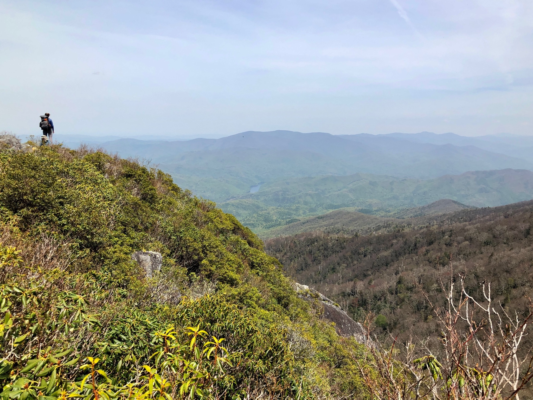
This was my first foray into eastern US backpacking, and while I’d heard about the AT’s infamous “green tunnel” I hadn’t experienced firsthand the difference between the stark, dry, limitless vistas you see out west and the lush, heavily forested terrain you go through on the BMT, the AT and other nearby trails.
 Whenever we got above a certain elevation on the BMT, huge rhododendron bushes created a fascinating tunnel effect. It was actually quite interesting and scenic, and I can only imagine how stunning such areas will be in a few weeks when the bushes are in bloom.
When we started our trip the deciduous trees hadn’t yet leafed out, so we could see other mountains, rivers and lakes through brown lacy curtains of tree limbs. Later, as green leaves began to proliferate, glimpses of faraway landscapes were even more curtailed, but it was fascinating to feel the presence of dark masses of mountains barely visible through the woods around us.
Yes, there are switchbacks out east
I’d been led to believe that contrary to the generally horse-graded trails in Colorado and other areas out west, the BMT was a hiker-only trail with hellaciously rocky, root-filled climbs going straight up and down innumerable mountains. In fact, the BMT does have switchbacks – and maybe this makes sense, since the BMT was only officially opened in 1980 and trail building principles have changed since the mid-1900s. For the most part, climbs and descents on the BMT seemed to make appropriate use of switchbacks, both in and south of the national park.

Exiting the tunnel on the Road to Nowhere
A goodly portion of the BMT is actually flatter, wider trail. While there aren’t many stretches of pure road walks, several miles of the BMT follow old, abandoned rail beds or dirt roads.
A long (at least 15 miles) stretch of the BMT follows an abandoned “road to nowhere” within the national park which had been proposed for residents displaced by the construction of Fontana Dam so that they could visit family cemeteries. You even pass through an eerie 1,000-foot tunnel intended for this road but never completed.
The BMT is a serious trail
While many miles of the BMT consist of soft, easy dirt trails – less worn down than the AT’s trails in this area – there are some segments that are kick-ass hard. In particular, the stretch around and north of the Hangover – just south of the national park – is very interesting rock- and root-scrambling. A commenter on FarOut said the stretch reminded him of the northern Long Trail: i.e., not easy. As a nearly 65-year-old I found this segment to be fun as long as I carefully placed my feet and trekking poles. But we were lucky to traverse the section in dry weather; it would have been serious “Type 2 Fun” in rainy, slick conditions.
 Some of the trail sections have had major blowdowns and sketchy creek crossings – especially the Pole Creek section in the national park. Even if you’re comfortable hopping from boulders to moss-covered logs to get across some creeks, you’ll probably have a half dozen or more unavoidable creek fords where you may be glad to have river shoes. I was really happy I’d thrown some sandals into my pack at the last minute.
None of the creek fords were concerning: we’re not talking raging PCT whitewater here. I was a little worried that with all the rain the creeks would be higher, but that wasn’t the case. While the heavy rains we experienced undoubtedly helped keep some drinking-water sources in good condition, the weather didn’t seem to have much of an effect on the fords. At least that was our experience.
Diamonds aren’t forever
 Most stretches of the BMT are well marked with white diamond blazes, and within the national park the BMT is now generally marked with small green-and-white placards below the standard wooden trail signs. (There’s even a “Northern Terminus” placard now at Baxter Creek, which is nice for photos. It’d be great if there could someday be some interpretive signage about Benton MacKaye and his role in creating the AT and promoting wilderness recreation.)
However, be forewarned that in Georgia and Tennessee wilderness areas there are no diamonds, and in these areas the trail signs don’t necessarily specifically reference the BMT.
Especially where diamonds were absent, we found the FarOut app to be a great resource to stay on track. Gaia was also handy to get a broader perspective of the regions we were traveling through.
But apps don’t always work. With heavy tree cover, GPS’s and your smartphone map apps like FarOut or Gaia may have trouble acquiring an accurate signal. One time I didn’t take this into account, and I ended up getting on the wrong trail for nearly a mile at a confusing trail junction south of Tapoco Lodge. I thought I’d confirmed the correct route on FarOut but my cursor apparently hadn’t had a clear view of the sky to update itself.
Lots of water, but not everywhere

A poop trowel serves double duty as a water funnel
The BMT generally has tons of places to get drinking water, but even in wet April conditions we had a couple of places where water was hard to find for up to 10-15 miles. These stretches are generally well marked in FarOut.
The BMT has several beautiful waterfalls and cascades flowing down smooth rock faces. We spent a glorious afternoon hanging out by one inviting cascade and dunking ourselves into safe, ice-cold pools.
Few people
I’d heard that few people hiked the BMT – whether as day hikers, overnighters, or thru hikers – especially compared to the northbound crowds on the southern Appalachian Trail this time of year. That was definitely our experience. Some days we saw no other backpackers or even day hikers, and even on the busiest days we saw only a handful of other hikers. The peace and silence on this trail is glorious.
We loved using the free Merlin app to identify by sound the dozens of different birds we could hear. My favorites were the Eastern Whippoorwill and the Wood Thrush: birds I never saw but often heard.
I had solo hiked most of the Colorado Trail and all of the Collegiate Loop, but on this trail I was glad I had companions. One day a park ranger texted me asking if we’d seen a 68-year-old man who’d gone missing in the backcountry not far from us. I pray that he’s safely found. A slip on a wet, mossy rock or log off trail might be catastrophic to a solo hiker.
As for our fellow thru-hikers, we saw only a few. I saw more solo women than men hiking this trail, including one woman doing the Pinhoti Trail, the BMT, and the AT all in the same year, and another woman doing a 550-mile loop of the BMT and the AT.
No bears, ticks or mosquitoes … but hogs galore, and mice
Well, almost no bears. During my three weeks on the BMT I saw only a glimpse of one bear in the Tennessee woods. At dusk near Tapoco Lodge my companions saw five bears. At the same time I was behind them lost on the wrong trail, and I didn’t see a single bear. I wonder if the umbrellas we often used in the rain spooked nearby bears.
We saw virtually no ticks. I think that liberal pre-trip application of permethrin to our clothing and camping gear helped deter ticks, but I was also told that they’re not as much of a problem in the springtime.
I’d expected to endure mosquitoes but I never saw a single mosquito on the entire trip. I understand that later in the summer flying insects can be quite a nuisance.
I saw three feral hogs, and we saw signs everywhere of their rooting for grubs or whatever in the ground. The hogs ran away from me as fast as possible.
All the campsites inside the national park have permanent metal-cabled bear hangs that are easy to use: no rock bags required. At Enloe Creek Campsite there’s a funky bear hang that looks kind of like an angled metal flagpole. On that one, a courageous mouse must have run up the pole and jumped into my bag. It chewed through my Mylar inner bag and ate a hunk of one of my prized Pop-Tarts. In true hiker trash fashion, I ate the rest of the Pop-Tart with no ill effects thus far.
Few campsites
Unlike the Colorado Trail where there are literally hundreds of good, sustainable tent spots, the BMT has relatively few campsites. Most of them are noted on FarOut. Once you’re in the national park you must use officially designated campsites that you need to reserve in advance, but except for the Laurel Gap Shelter we never saw a full campsite.
The BMT has only two shelters. One is in a short stretch of trail where no tenting is allowed, and the other is the impressive Laurel Gap Shelter close to the northern terminus of the trail. (At Laurel Gap tenting is still currently allowed as a temporary aftereffect of Covid, but that may change soon.)
Great people
After reading some rather insulting FarOut entries I wasn’t sure what reception we’d get in the towns and campgrounds we were hiking through. In fact, southern hospitality isn’t a myth and we enjoyed each of the handful of communities we visited.
Every time we went into a town or village – Skeenah Creek Campground, Blue Ridge, Reliance, Tapoco Lodge, and Fontana Village – we met the friendliest, kindest, most helpful people. We were given expensive Mountain House meals by weekend hikers who’d overestimated their hunger. The owner of the Skeenah Creek Campground gave us a great deal on beds in his own house, drove us to get a meal, and even made breakfast for us. The owners of Reliance Fly and Tackle and the Webb Brothers Grocery couldn’t have been nicer. National park RV campers fed us, gave us shelter and seats at their fire, and plied us with wine and whiskey. And the owner of the Hiwassee Outfitters Resort gave us a good deal on a vacant cabin and asked how she could help future hikers.
We had no problem getting a hitch into Blue Ridge, and the three shuttle services we used – to get to Amicalola Falls, to return to the trail from Blue Ridge, and to depart from the terminus to Asheville – were all great. (Unlike some shuttlers on the Colorado Trail, shuttling out east is a business with fixed, sometimes three-figure, prices.)
Final thoughts

Benton MacKaye commemorative plaque near the southern terminus of the BMT
All three of us agreed that this trail felt harder than the Colorado Trail, even considering the latter’s high altitude and lightning storms. If you’re not sending yourself resupply boxes, be prepared to eat mostly tortillas, peanut butter, ramen, ramen, jerky, Pop-Tarts and Snickers. You’ll survive.
The BMT Association has done an absolutely fantastic job providing BMT information on their website and in their publications. They have an entire sub-site devoted to thru-hiking. Their printed Thru-Hiker’s Guide was especially valuable, and well worth taking along on the trail.
If after reading this lengthy missive you have more questions about the trail and thru-hiking it, please feel free to contact me directly or ask questions in the comment section and I’ll try to respond ASAP. I loved this gorgeous, little-known trail through America’s southeastern Appalachian wilderness and would love to help others who want to try it.

This website contains affiliate links, which means The Trek may receive a percentage of any product or service you purchase using the links in the articles or advertisements. The buyer pays the same price as they would otherwise, and your purchase helps to support The Trek's ongoing goal to serve you quality backpacking advice and information. Thanks for your support!
To learn more, please visit the About This Site page.

Comments 16
Great round up, Rolf. Thanks for sharing. This just bumped the BMT up my bucket list a few spots. Glad the hogs ran away from you and not the alternative option.
The closest I got to hogs (thankfully) was a fantastic North Carolina pulled pork sandwich at Reliance Fly & Tackle in Reliance, Tennessee. Didn’t think to ask them whether it was wild game.
I’m starting my BMT AT loop in 4 weeks!!! I can not wait. Your insight is appreciated.
Megan, we met a young hiker named Sunshine (Julia) who was soloing the AT-BMT loop and loving it. I’d hoped to do this too but ran out of time. She’d done the AT southbound and was doing the BMT northbound but left the very last portion (in the national park) for sometime in May because she had to go off trail for a wedding. Maybe you’ll be on the trail the same time as her!
Megan, I didn’t see your post so was unable to wish you all the best! How did it go? Where did you start and end? What were some of your favorite parts? I’d love to do the AT in this area someday. Thanks for commenting!
Um … never mind! I DID see your post … the blog just wasn’t showing my replies right away.
I really appreciate this post. I’ve done the AT and am presently 1/3 of the way done with Florida Trail, which has led me to the conclusion that, as a Lasher, I need to complete the Eastern Continental Trail. Your post has given me a good picture of what I might experience on the BMT portion of the ECT. And, by the way, I’ll be trekking in your state this summer with a thru-hike of the Colorado Trail. It’s certainly fun to explore these varying terrains.
Thank you, Ruth! I’m sure you’ll enjoy the CT. If I can help you with logistics or a northeast trailhead shuttle please feel free to contact me.
Darn it Ruth, I didn’t see your post until now. Congratulations on your Colorado Trail adventure! I hope to hike the AT portion that creates a loop with the BMT in this area. You’re amazing! Thanks for commenting.
LOL – I DID see your post after all; for some reason my replies weren’t showing a little while ago. Oh well!
Rolf, thanks for putting together this summary. Gives me some motivation to put together a trip with my sons.
Brad
I have two sons myself and I’m sure they would have LOVED the opportunity to maybe see bears and hogs! It was a great trail and would be fun for boys … with safe leadership of course!
Greetings,
Great post. I am about to thru hike the BMT and was wondering if you could provide the name of the shuttle services you utilized. Thanks.
D’Anne, I’m so sorry, I didn’t see your post earlier so didn’t respond. I hope you had a fantastic trip!
How was your trek thru the BMT? I want to do it but not alone because I’m deaf. I was thinking about next early October. But I am curious how your trek fared. Thank you.
Hi Brenda! I hope you find a friend or two and have a blast on the BMT! Hey, as a deaf backpacker you should check out a recent episode of Backpacker Radio where Zach and Juliana interview a deaf hiker who thru-hiked the Colorado Trail recently! (He does have cochlear implants so that makes a world of difference for him, but he also talked about backpacking by deaf persons generally. If I can help provide any additional information about the BMT or the Colorado Trail, please don’t hesitate to contact me. I’m on Facebook/Messenger.